Route 66 in Godley IL
Index to this page
About Godley IL
Facts, Information and trivia
Elevation: Elevation 577 ft (176 m). Population 610 (2024).
Time zone: Central (CST): UTC minus 6 hours. Summer (DST) CDT (UTC-5).
Godley is a village in both Will and Grundy Counties, the county line runs along Kankakke Rd on the western side of town.
History of Godley
Illinois was initially peopled when the Paleoindians reached the area at the end of the last Ice Age some 11,000 years ago.
During the historic period, French fur trappers from Canada and Louisiana explored the Great Lakes and the Mississippi River basin, reaching Illinois in the 1660s, they encountered Illini (Illinois) natives and Kickapoo people.
After wars between France and Britain, the land passed to the British and after American Independence in 1776, to the U.S.A., it was organized into a Territory and in 1818 admitted into the union as the state of Illinois.
In 1836 Will County was established and named for Dr. Conrad Will (1779-1835) a businessman who had been a member of the first Illinois Constitutional Convention and later a member of the Illinois Legislature. Grundy County was created in 1841 and it was named for U.S. Attorney General Felix Grundy (1777-1840).
Some pioneers settled in the area in the 1830s and 40s, but it was not suitable for farming. Coal was discovered in Braidwood in 1864 and that sparked the coal mining boom with many shafts being dug and other coal finds in what are now Godley, Braceville, and Gardner. This led to a town being platted to house the mine workers that flowed to the area. It was named Godley.
The name: Godley
The origin of the town's name is uncertain. But the surname is a habitational name: for those who lived in Godley, Cheshire, or Goodleigh, Devon. Derived from the Old English words "Goda" (good) and "leah" (woodland clearing): Good clearing in the forest.
Coal brought work and prosperity, there were almost 5,500 miners in Grundy and Will counties in 1885. The village incorporated in 1888 and in those days had a population of nearly 500 people and its population grew until the 1900s. The mines further south in Illinois had thicker veins of coal and were more productive. Output in Godley fell and finally by 1916 the mines here closed, followed by the one at neighboring Torino in 1918. Men lost their jobs and moved on to the mines further south, with their families. Godley became a ghost town with only 50 residents and 10 houses occupied at that time.
When Route 66 was created in 1926 it followed State Hwy 4's alignment. It became US ALT 66 in 1939 when a new US 66 was built through Godley on the north side of the railroad.

Hotels and Motels in Godley
There are several hotels close to Godley and in the neighboring towns along Route66.
>> Book your Hotel in neighboring Wilmington or Dwight
Find More Accommodation near Godley along Route 66
Below you will find a list of some of the towns along Route 66 east and west of this town; click on any of the links to find your accommodation in these towns (shown from east to west):
Along Route 66 in IL
- Hotels in Illinois
- Route 66 Starting point ▸ Chicago
- Lockport
- Willowbrook
- Bolingbrook
- Plainfield
- Romeoville
- Joliet
- Wilmington
- Dwight
- Pontiac
- Chenoa
- Normal
- Bloomington
- Atlanta
- Lincoln
- Springfield
- Raymond
- Litchfield
- Staunton
- Williamson
- Hamel
- Edwardsville
- Collinsville
- Troy
- Glen Carbon
- Pontoon Beach
- Granite City
- East St. Louis
West in Missouri
- Hotels in Missouri
- Florissant MO
- Bridgeton MO
- St. Louis MO
- Kirkwood MO
>> See the RV campground nearby in Braidwood and also in Joliet
The Weather in Godley
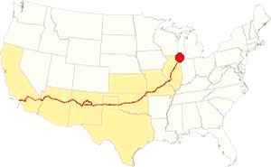
Map showing the location of Godley, Illinois on U.S. 66
The climate of Godley is classified as humid continental and has clearly marked seasons with hot and often humid summers, cool and wet springs, mild autumns and cold winters.
Temperatures: Average high in Jan (winter) 31°F (-0.3°C) and the average low is 17°F (-8.6°C). Average high in Jul (summer) 84°F (29°C), with an average low of 64°F (17.7°C).
Precipitation: Rainfall is between 3 and 4.3 (78 and 110 mm) inches per month between April and November, falling to around 1.7 in. monthly (28 mm) during winter. Average rainfall is 36.82 inch (936 mm).
Snow: The city gets 28 inches of snow per year (71 cm), with the first snowfall usually taking place in November and the last one happening in April (with less than a quarter inch - 8 mm). You shouldn't see snow from May to September.
Tornado risk
The countis around Godley gets some 5 tornado strikes every year.
Tornado Risk: read more about Tornado Risk on US 66.
Map of Route 66 in Godley, IL
>> Our Custom map shows the alignments of U.S. 66 in Godley.

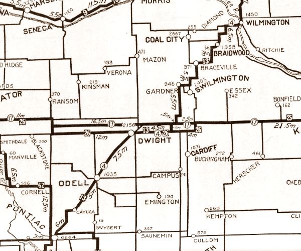
1928 Illinois State roadmap (see State Hwy 4A). Source
Click map to enlarge
Illinois funded its state highway system by issuing a bond in 1918, this resulted in SBI 4 (State Bond Issue) highway number 4 being built along the former "Pontiac Trail" from Chicago to St. Louis. By 1923 it had been totally paved and in 1926 Route 66 was created and aligned along it. In the area near Godley the first IL-4 had a zig-zagging course that was straightened out when it was paved.
The map below was published in 1924, two years before Route 66 was created. It displays the "Auto Trails" or roads that were suitable for cars. The ones near Godley are marked with numbers: as "13" and "26" with white numbers inside black squares, these are the "trails", standing for "Mississippi Valley Highway" and "Blue Grass Road" respectively.
The number "4" inside a white circle is what originally was State Highway 4.
The Route 66 alignments in Godley
US 66 from 1926 to 1939
The original Route 66 is present IL-53, running along the eastern (or southern) side of the railroad from Braidwood through Godley into Gardner. It is marked with a green line in our Custom map
US 66 from 1940 to 1956
In 1939 the highway was realigned north of Braidwood, creating a faster and far straighter road that ran through Plainfield and bypassed Joliet and Wilmington. This new highway is marked with a yellow line in our Custom map
It continued west, with a completely new aligngment built along the north side of the railroad, parallel to the original roadway but with the tracks separating both alignments. It is marked with a blue line in our Custom map.
The "new" highway from Plainsfield to Gardner became Route 66 and the "old" one was renamed Alt US 66.
ALT US 66 1940 to 1967
The 1926 alignment from Gardner to Romeoville through Joliet became ALT US 66 and remained so until it was eliminated in February 1967 and replaced by Illinois State Highway 53 from Welco Corners to Gardner.1
Both alignments met on the southern side of Gardner.
US 66 from 1956 to 1977
In 1956 US 66 was moved further west to a new alignment bypassing the towns from Braidwood to Gardner. Route 66 shared the road with the new freeway (I-55). This roadway is now overlaid by the freeway. See the violet line in our Custom map.
Alternate US 66
In 1959 the American Association of State Highway and Transportation Officials (AASHTO) came up with the "Alternate" designation.
It was to be used to designate a highway that branches off from the main one, passing through certain cities and then links up with the main route again.
If the Main and alternative routes followed a similar course, the better built or shorter highway would be the one marked as "Main", while the other would become the "Alternate" one.
There are only six places along Route 66 where an Alternate 66 alignment existed: From East to West they were this one close on Route 66 into Chicago, Carthage MO, the one in Joplin MO, Oklahoma City, Alt 66 in San Bernardino, California, and the one leading into Los Angeles CA.
Route 66 is a Historic highway and has also been designated as a National Scenic Byway and an All-American Road in the state of Illinois.
The Route 66 alignments near Godley
Description and interactive maps of US 66.
- Pontiac to Springfield (next)
- Chicago to Pontiac (Godley's)

Godley's Route 66 Landmarks and Attractions
What to see in Godley
US 66 in Godley: historic context
The WPA's guide to Illinois written in 1939 describes the town: "GODLEY... now merely a highway stop with one school, a few taverns, and a score of scattered houses, was once a booming coal town peopled by a thousand Scotch, Irish, and Welsh, the overflow of Braidwood's mining population. During the 1880's, 21 mines were in operation within a mile and a half of Godley; by 1906 all were closed. Bohemians have since settled in the village. Their pursuits are largely agricultural, and Godley's boom mining era is recalled only in the great 'gob-heaps' that almost encircle the town."
Jack DeVere Rittenhouse published the "Guide Book to Highway 66" after driving it from Chicago to Los Angeles in 1946. He also described Godley:
No facilities. Once a booming mining community. Now only a few homes remain. South of the town are more slag heaps. Rittenhouse (1946)
Your Route 66 road trip through Godley
Drive west from neighboring Braidwood, after 2.5 miles, to your left is the small village of Godley. It is similar to Rittenhouses description, with a few homes, and one tavern, and the Mining museum.
Godley Illinois Route 66 Mining Museum
Wayside Exhibit and silhouette
150 South Kankakee St. The museum reminds us of the influence that coal mining had on these Route 66 communities. It also tells us about the fossil finds in the slag heaps of the area. There is a Route 66 silhouette and a Wayside Exhibit panel next to the building.
Mining Museum in Godley, Illinois with silhouette in the foreground
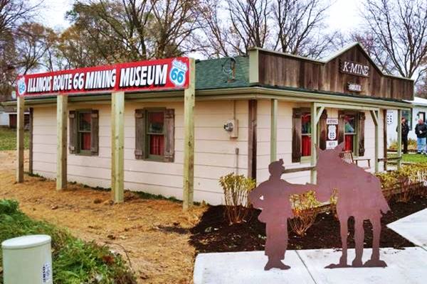
The Godley Silhouette
Beside the old mine museum's building there is a steel sheet silhouette depicting a coal miner and his donkey. The wayside exhibit next to it tells about "Mining Black Diamonds", of the boom-bust cycle suffered by the region after coal (black diamonds) was discovered here in 1864.
Coal in the region
Thomas Byron struck coal while digging a well in 1864. A Scotsman, James Braidwood with sound engineering knowledge sunk the first mine shaft the following year. The coal boom had begun.
More coal mines opened across the region, in Diamond, Coal City, Torino, South Wilmington, and Godly. Towns and villages were established to house the workforce and soon thousands of miners toiled in the mines.
The railroad switched from burning wood to burning coal in their locomotives and the railroad provided a quick and simple means for getting the coal into the Chicago urban market.
The work was dangerous, miners breathed coal-dust laden air in cramped, deep shafts. Tragedy struck when the Diamond Mine flooded in 1883 killing 74 workers, two of them just boys aged 13 and 14.
The workers unionized in 1890 (United Mine workers Union) to fight for better working conditions and wages. But shortly after the mines began closing, cheaper mines had opened further south in Illinois. Mine workers migrated following the mines bringing ruin to the local communities.
Less labor intensive strip mining began in the late 1920s, digging up the surface and creating large slag piles. By the early 1970s, the coal period had ended.
The houses of ill repute, Godley's bordellos
The miner towns catered to the needs of the miners, bars to quench their thirst for alcohol and bawdy houses to meet their needs. When the mines closed for good in the 1890s, Godley "consisted of a store, over 18 taverns and about 8 houses of ill repute." 1
These bordellos kept on going until the 1960s; Brorsen 2 reports that "In 1962 Godley had three taverns , a restaurant and two whorehouses" and Andy Dawkins mentions the whorehouse in Godley in 1966 3.
A Braidwood resident 4 recalling his teen days in the 1950s and 60s tells us that "The tavern in Godley was the more specific. It was known for its Mafia-run prostitution house. Although my Lewis College classmates and teammates had never heard of Braidwood, they usually were acquainted with Godley... When the county police would come, ladies would run across the street to avoid being arrested."
These recollections are backed by the media; the Chicago Tribune published an article on August 25, 1962 5 informing the death of an ex-convict Alex Sorrentino who was a lieutenant of three Mafia bosses, one of them involved in "vice and gambling in... Will county" he was also a "procurer" for "Joseph Barrett Jr... the operator of a notorious syndicate bordello in the hamlet of Godley, in northern Grundy county."
The Joliet Herald News reported in August 2013 6 that "Fire destroys former reputed brothel used by Al Capone... A brush fire destroyed two homes Saturday in the Route 66 town of Godley, Ill., including one structure that reputedly was a brothel used by notorious Chicago gangster Al Capone."
This place was located at 335 S. Route 53 in Grundy County. ( 2008 street view).
The County Line Brothel Myth
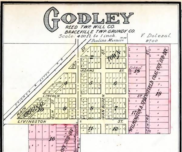
As mentioned above, there is an urban myth that one of the brothels was located on the county line so that the customers and ladies could run across the street to escape from police raids. There is another version on Internet where the "house" was located in a railroad car and it was moved from one side of the county line to the other when the cops came. The county line ran along Kankakee Rd, with Grundy County to the west and Will County to the east. And the alleged brothel that burned in 2013 was less than 200 yards from the county line. Below is a 1910 map of Godley, the dashed line marks the county line.
Slag Heaps
As you can see, driving across Godley, the countryside has some farms and woods. The scars of the extensive coal mining in the area are not evident nowadays in Godely, hidden by the trees and remedied by the authorities who have graded and removed slag heaps, filled in mine shafts, and sown plants to prevent erosion.
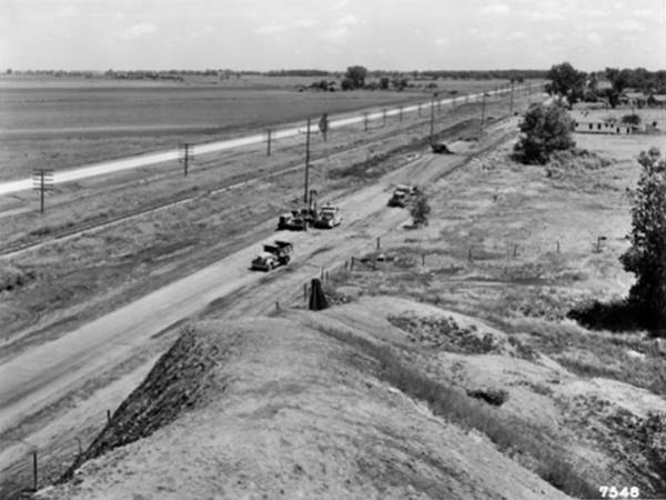
Godley had two mines, the largest was the K-mine ran by The Chicago, Wilmington and Vermilion Coal Co. when it closed in the late 1890s, M-mine opened but it soon closed. K-mine on the south side of town left a large pile of coal refuse by the side of Route 66, this is the one mentioned by Rittenhouse in 1946. You can see it in the black and white picture below taken in 1939; it looks north, from the top of the slag heap, Godley's "brothel" is on the right side, in the foreground is the old U.S. 66 that is being repaved to become ALT 66, and beyond the railroad is the new U.S 66 running along the north side of the tracks.
This gray pile of rocks and dust was remedied in 1999, the pictures below show it at that time while remediation was ongoing; notice that one of the images shows the same view that was pictured in 1939, looking north from the top of the heap:
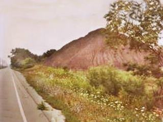
Slag pile before remediation, 1999. Godley Alt 66. Source
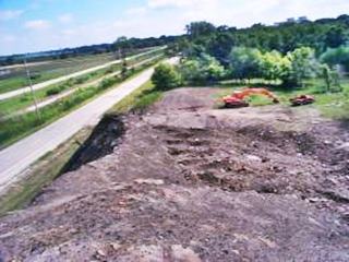
Slag pile being removed, 1999. Godley Alt 66. Source
This same spot nowadays has soft hump, seeded with grass.
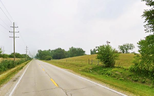
The local authorities created the Godley Park District and named it the K-Mine Park on this site acquiring 47 acres of land on the south side of the village where the mine shaft was located. It opened in 1985. It has grown to include picnic tables, outdoor grills, a 5-acre deer park and other outdoor and recreation facilities.
Continue your Road Trip
Your Route 66 Road Trip in Godley ends here, head west to visit the next town, neighboring Braceville and continue your journey.

Sponsored Content
>> Book your Hotel in Chicago

Credits
Banner image: Hackberry General Store, Hackberry, Arizona by Perla Eichenblat
Jack DeVere Rittenhouse, (1946). A Guide Book to Highway 66.

