Route 66 in Cicero IL
Index to this page
Cicero IL
Facts, Information and trivia
Elevation: Elevation 607 ft (185 m). Population 78,910 (2024).
Time zone: Central (CST): UTC minus 6 hours. Summer (DST) CDT (UTC-5).
Cicero is the only incorporated town in Cook County, Illinois.
History of Cicero
This region was peopled some 11,000 years ago at the end of the last Ice Age. During recent historic times after the mid 1600s, French explorers encountered the Native American Potawatome people here and made the territory part of their Canadian colony. After being defeated in Seven Years' War, the French ceded Illinois to Britain in the 1760s, and in 1783 it became part of the newly formed United States.
A treaty with the Natives led to the establishment of Fort Dearborn on the Chicago River in 1803. It was burned down during the 1812 War with England and rebuilt four years later.
Illinois became a state in 1818 and Cook County was created in 1835. Named for Daniel Pope Cook (1794 - 1827) newspaper publisher and lawyer, he was the first Attorney General of Illinois, and also a congressman. Cook County is the second-most populous county in America after Los Angeles County,
In 1849 Cook County created the 36 sq.mi. township where Cicero is located, and in 1857 the "Town of Cicero" was organized to govern it. It incorporated with a state charter in 1867.
The name "Cicero"
The town was named after "Cicero" in New York, which in turn was named for Marcus Tullius Cicero (106 BC- 43 BC), a Roman politician, lawyer and orator.
He was always in favor of the republican government and after Julius Caesar's death he won the enemity of Mark Anthony as he opposed the new regime. He was declared an enemy of the state and murdered by Mark Anthony's soldiers.
The city of Chicago annexed a large portion of Cicero in 1899 and then, in 1901 Berwyn and Oak Park separated, now only 6 sq. mi. remain as Cicero.
The Burlington, Illinois Central and Belt Line served the town an attracted many industries to it.
Some Cicero Trivia
The pilot episode "Uno" of the TV series "Better Call Saul" mentions Cicero as the hometown of Saul Goodman (Jimmy McGill).
Velma Kelley (played by Catherine Zeta‑Jones in the 2002 movie Chicago) is accused of murdering her husband and her sister in a hotel in Cicero.
Route 66 was aligned along Ogden Ave. in 1926 and remained there until 1977 when it lost its certification.

Accommodation in Cicero
> > Book your hotel in Chicago
Find More Accommodation close to Cicero along U.S. 66
Below you will find a list of some of the towns along Route 66 east and west of this town; click on any of the links to find your accommodation in these towns (shown from east to west):
Along Route 66 in IL
- Hotels in Illinois
- Route 66 Starting point ▸ Chicago
- Lockport
- Willowbrook
- Bolingbrook
- Plainfield
- Romeoville
- Joliet
- Wilmington
- Dwight
- Pontiac
- Chenoa
- Normal
- Bloomington
- Atlanta
- Lincoln
- Springfield
- Raymond
- Litchfield
- Staunton
- Williamson
- Hamel
- Edwardsville
- Collinsville
- Troy
- Glen Carbon
- Pontoon Beach
- Granite City
- East St. Louis
West in Missouri
- Hotels in Missouri
- Florissant MO
- Bridgeton MO
- St. Louis MO
- Kirkwood MO
>> See the RV campgrounds in Chicago or in Joliet.
The Weather in Cicero
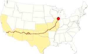
Map showing the location of Cicero, Illinois on U.S. 66
The climate in Cicero is a humid continental one with all four seasons distinctly represented; summers are hot and humid, spring is wet and cool, autumn is mild and pleasant while winters are quite cold.
Temperatures: The average winter (January) high is 31°F (-0.3°C); and the average low is 17°F (-8.6°C). The summer average high (July) is 84°F (29°C) and the average low is 64°F (17.7°C).
Rainfall ranges from 3 to 4.3 (78 and 110 mm) inch monthly from April to November, and falls to a drier 1.7 in. (28 mm) the rest of the year. On average, Cicero gets 36.82 inches of rain each year (936 mm).
Snowfall: on average, 28 inches (71 cm) of snow falls each year. The first snow falls in Nov. and the last (less than 1⁄4 inch or 8 mm) falls in April. There is usually no snow between May and September.
Tornado risk
Cook County may suffer some 4 tornados each year. Tornado Risk: read more about Tornado Risk on US 66.
The Maps of Route 66 in Cicero
>> Our Custom map shows the alignment of Route 66 in Cicero.
The map below was published in 1924, two years before the creation of U.S. Highway 66. The map displays the Auto Trails in NE Illinois around Chicago.
Auto Trails were highways that were in good conditions and could be used by motor vehicles. Some are marked with numbers inside black boxes; they are the "named trails." Like "78" in Cicero that was the "Southwest Trail" or "15", the "Cannon Ball Trail". Illinois State highways are marked with numbers inside white circles. For instance Route 66's predecesor State Highway 4 is marked with a "4" inside a white circle in this area and it can be seen running from Chicago to Lyons.
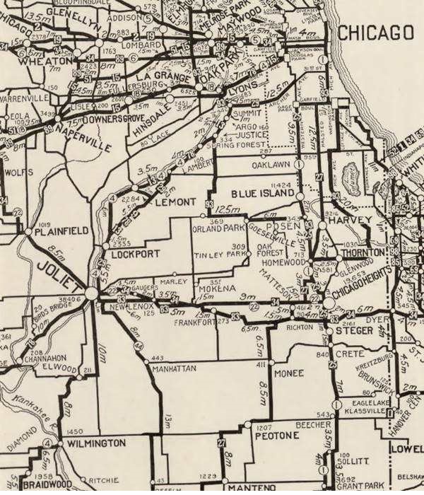
The map shows LaGrange and Lyons, Cicero does not appear in the map, it is beside Lyons.
Route 66 in Cicero

1927 Chicagoland map. Source

1928 Illinois State roadmap (see State Hwys 4 and 4A). Source
Route 66 ran from 1926 onwards through Cicero, that can be seen in both maps above.
Highway 66 from 1956 to 1977

1969 Illinois State Roadmap. Source
Click map to enlarge
The highway map published in 1969 shows the changes in the network, by the 60's, Chicago's urban sprawl grew expanded and freeways crossed it. I-55 and US-66 ran together into Chicago to the exchange with I-294, where they split, I-55 running further south and US-66 north. See Cicero on the upper right.
The old Route 66 is a Historic highway and has also been designated as a National Scenic Byway and an All-American Road in the state of Illinois.
The Route 66 alignments near Cicero
Description and interactive maps of US 66.
- Pontiac to Springfield (next)
- Chicago to Pontiac (Cicero's)

Cicero's Route 66 Landmarks and Attractions
US 66 in Cicero: historic context
The "Guide to Illinois" published by the WPA in 1939 mentions Cicero as part of its Route 66 tour ("Tour 17"). The WPA says: "Cicero... largest of Chicago's suburbs... it's Western Electric plant alone employs, at peak periods, more than the suburb's total working population".
It gave a brief history of how these "swampy lowlands" became a town, how it was drained and grew.
We also learn that "among those attracted to Cicero in the booming twenties was Al Capone, 'Public Enemy Number One,' who established headquarters in a hotel near the Western Electric Company plant" to organize his gambling houses and honkytonks along the streets that ran along the sides of the plant located on Cermak Rd. and Cicero Ave. opened in 1902 employing 40,000 workers to manufacture phones, radios and other electrical appliances.
What to see and do in Cicero
This leg of your Route 66 Road Trip through Cicero is very short, it is a 2.5 mile drive along Ogden Avenue, between Chicago in the east and Berwyn in the west. It begins on the western tip of the Chicago city alignment at Ogden and the railroad underpass just west of South Kostner Ave.
Ogden Avenue Bridge (gone)
See the different alignments here in our custom map. Blue is the original 1929-40 roadway, green is the 1940-98 steel bridge. Pale Blue is the current alignment.
When Route 66 was created, it was aligned along Ogden Ave. and here it met the combined tracks of the Chicago & Illinois Railway and the Belt Railway of Chicago, that had a north to south course, and cut across the avenue. Both railroads had multiple spurs into the warehouses of the factories in Cicero and Chicago.
The Chicago, Burlington and Quincy Railroad that ran with an east to west course, crossed linked to the other two railways here and crossed Ogden. It was a dangerous grade place for a grade crossing so the original alignment solved the problem by running north of the CB&Q railroad and then turning sharply south into the Cicero Ave underpass, and then again sharply west along Ogden, as shown in the map below (Route 66 runs along the red line).
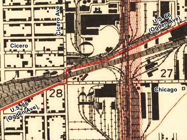
The two right angle turns were inconvenient, and the 31,000 cars a day that passed under the tracks caused frequent traffic jams, so in 1940 a bridge was built here to cross the tracks.
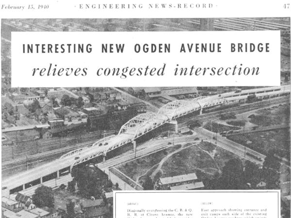
It had five truss spans 121 to 233 feet long and a 44-foot wide roadway with two beam spam aproaches on each side. It was 1,520 feet long and used 2,200 tons of structural steel.
Its eastern access had two independent ramps on each side of Ogden Ave, which continued straight to connect with Cicero Ave.
The image above looks towards the northeast, with Chicago to the right and Cicero to the left. See the same view nowadays.
The bridge grew old and weight restrictions were imposed, the right lane was closed to traffic. It was close to collapsing so it was taken down in 1998 and the current alignment opened in 2001.
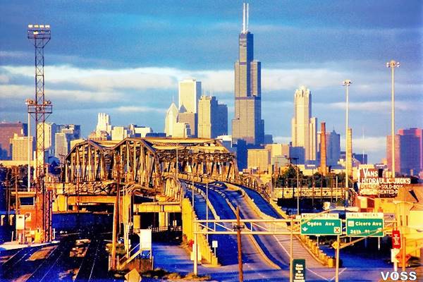
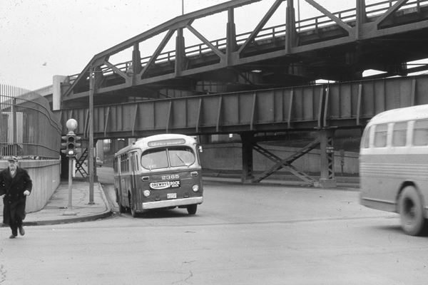
The 1950s image looks eastwards from Cicero Ave. along Ogden, that passes under the CB&Q railroad, above is the steel viaduct carrying US 66.
Ogden Avenue
The throughfare was named for Chicago's first mayor: William Butler Ogden, this avenue runs for 37.5 miles (60.4 km) from Chicago (Chestnut St. near Milwaukee and Chicago Avenues) all the way to Naperville, IL
When Chicago was a fort on Lake Michigan (Fort Dearborn) in the early 1800s, the trappers used a muddy known as "Ottawa Trail" that linked the fort with what nowadays is Lisle.
The trail was improved and a stagecoach service was established, stopping at what now is Hinsdale in the 1830s, but the cart traffic ruined the dirt road, forming ruts. The trail was a muddy bog during the rainy season. Then some entrepreneurs built a toll road, the "Plank Road", which made traffic flow easily across the quagmire.
Plank Road
Construction began in 1848 and it was known as "The Southwestern Plank Road", it was the first of many that would radiate from Chicago. This one followed the trail to Lyons and in 1851 it was extended through Lisle to Naperville.
The road was built with wooden planks with log stringers on their outer edges. The boards were 3 in. thick and 8 feet wide -rather narrow.
Toll fees were charged ranging from 3¢ for one hog or sheep, 12¢ for a horse and rider to 37¢ for a cart drawn by four hourses.
When the Chicago, Burlington and Quincy railroad began operating in 1863, the traffic along the plank road declined.
It was re-named in 1877 as Ogden Avenue., planks gone it was a gravel surfaced road. But by the early 1900s the first cars appeared and by 1914 it had been paved becoming a main throughfare.
Route 66 and US 34 were aligned along it in 1926 and in the 1930s it was widened to four lanes.
After crossing Cicero Ave. Route 66 continues with a Southwesterly course through an area with many warehouses, truck companies and flanked to the right by the railroad with sidings and container yards in a dull 1940s industrial setting.
Old Gas Station - Garage
Located to your left at 4901 W Ogden, on the SW corner with S 49th Ave., this building can be seen in a 1938 aerial photo of this area, before the Ogden viaduct was built. It was a gas station. By 1940, the viaduct's western approach ramp cut it off from through traffic along Route 66. It has survived with its corner office with glass bricks, two service bays facing the highway, and it extends along 49th St.
Cindy Lyn Motel
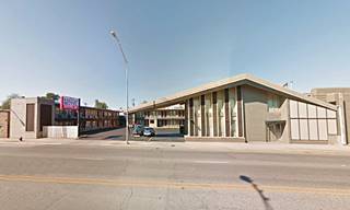
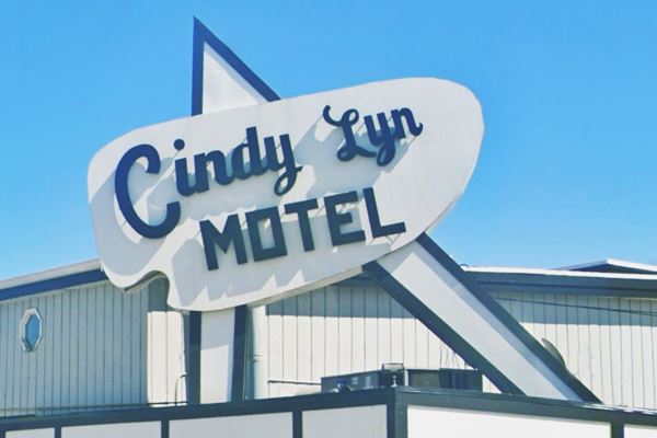
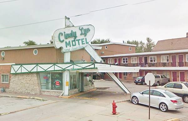
Ahead, to your left, at 5029 Ogden Ave and 50th Ct. is the Cindy Lyn Motel. It was renovated and upgraded; it is still open and catering to Route 66 guests. It has a distinctive neon sigh that incorporated into the canopy roof over the motel's office as part of a sharp angled structure. It is a Googie style building, a style that was popular during the late 1950s and mid-1960s. It celebrated the atomic and space ages with structures shaped like planets, stars, amoebae with sweeping shapes, boomerangs and overhangs that were lit with bright neon signs. Cindy Lyn Motel and Suites dates back to the early 1960s and appears in a 1962 aerial photograph of this spot.
Cindy Lyn Motel in Cicero, Illinois
Just ahead, at 5116 Ogden Ave. there is a castle-looking building with an ancient neon sign. The aerial photographs show it has been here since the 1930s. It appears to have been a garage, in 2024 it is a second hand restaurant equipment store; see its street view.
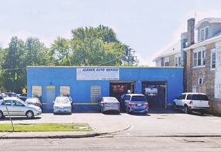
Two blocks west, at 5301 Ogden Ave., the 2013 Route 66 Survey for IDOT, reported a "Ca. 1940s Garage... A very plain-looking gas station, now painted. 〝Juanes Auto Repair〞." The aerial photos show a building here at least from 1938 onwards. The current one appears in 1962. It is pictured below.
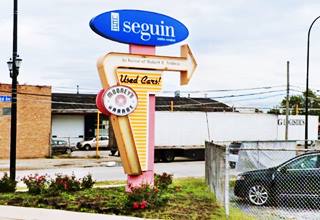
On the corner with South Center Ave. there is a modern retro neon sign, pictured above; a nice homage to Route 66.
Henry’s Drive-In
Americana & Kitsch and Neon Sign
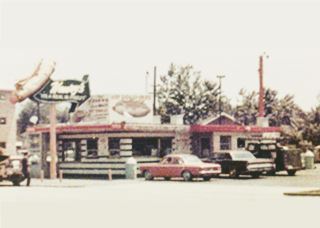
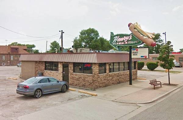
Continue west pass the railroad underpass and to your left, at 6031 West Ogden Ave. you can't miss it with its amazing neon sign that portrays a hot dog topped with mustard and french fries with a wavy green arrow stating "Henry's - "It's A Meal In Itself."
This is the place to stop at for a Chicago-style hot dog. A Route 66 Classic.
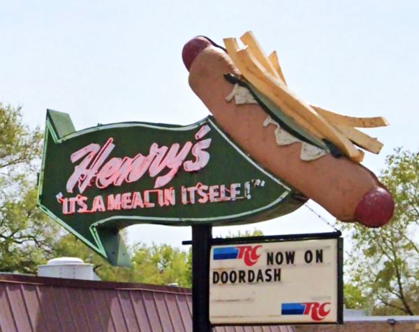
Bill Henry's business started in 1946 in a hot dog trailer on Austin, north of Ogden. Then he built his diner in 1950 and it has been catering to hungry travelers since then.
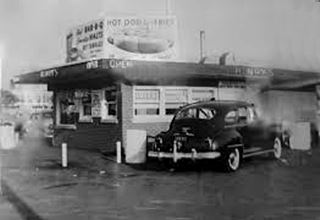
Henry's Drive In, 1950s. Source
Henry's Drive In, 1960s. Source
Phillips 66? vintage gas station
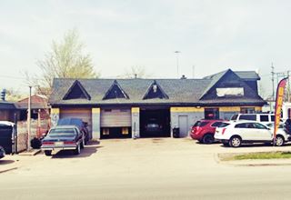
Across the street on the next block, to your right at at 6100 Ogden Ave. you will see another vintage former gas station. The 2013 survey describes it as "Ca. 1940s Garage 〝J & A Auto Repair〞 is in a gas station⁄auto service building constructed of brick." It has been here since at least 1938, as you can see it in an aerial photograph taken that year.
Cottage styled gas stations were popular in the early 1930s, they helped them blend in with their suburuban surroundings. Conoco, Phillips 66 and Pure favored this design with cross gabled roofs.
Drive on, and at South Lombard Ave, that marks the border with neighboring Berwyn, is a Classic Route 66 Sight, the site where the "Atlanta Muffler Man" -that holds up a hot dog- used to stand.
Original site of the Muffler Man Holding Hot Dog
Route 66 Iconic stop
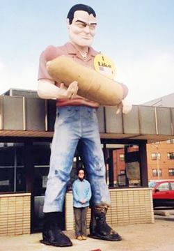
Hot Dog Giant in Cicero Illinois (now in Atlanta, Il). Source
At 6150 W Ogden Ave., Cicero. The 19 foot tall that stood here is now located in Atlanta, Illinois, as the Muffler Man Holding Hot Dog.
Also known as Paul Bunyon (yes, Bunyon with an "o" and not Bunyan with a "u") it was originally from Cicero.
Atlanta's Muffler Man was originally installed at the Bunyon's hot dog stand in Cicero, Illinois (see image), on Ogden Avenue.
Hamlet Stephens owned the stand and he purchased the gigantic fiberglass statue of "Paul Bunyan" to promote his business in 1966 and it stood over his shop for 38 years.
He deliberately spelled its name "Bunyon" (with an "o" instead of an "a") to avoid copyright issues. This "Paul Bunyon" held a gigantic hot dog in its hands.
In 2002 the stand closed and in 2003 the Bunyon Giant was moved to Atlanta. Stephens died in 2012 but his work lives on. The original building is still standing, as you can see below in the "Then and Now" sequence.
Muffler Man
Muffler Men are gigantic (18 to 25 feet tall -5.5 to 7.5 m) statues moulded in fiberglass and polyester resin used in the U.S. as eyecatcher advertising along roads and streets.
The first Muffler Man was a "Paul Bunyan" figure created for the Paul Bunyan Cafe on Route 66 in Flagstaff circa 1960; later it became the Lumberjack Café and now is Granny's Closet and it still stands nearby (See a street view of the Lumberjack today).
The mold was used to make many more Paul Bunyans which were placed in front of gas stations and garages. Some of them holding auto tires and mufflers instead of axes, and that gave them the name of "Muffler Men".
>> Learn more about the Muffler Men on Route 66
There are several on Route 66, for instance the Chicken Boy in Los Angeles (a Paul Bunyan with a Chicken's head!), and the Lauterbatch Muffler Man in Springfield, Illinois, or the Gemini Giant in Willmington, Illinois.
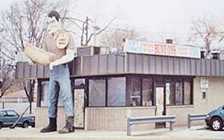
Vintage view of the Hot Dog Muffler man in Cicero, Il.
Your drive along Route 66 in Cicero ends here, but you can take a short side trip to visit some of the towns best known attractions.
Short City Tour of Cicero
Start your tour at the Cindy Lyn Motel to begin a short 7 mile round trip into Cicero to see some intersting landmarks that are not located on Route 66; this is the map with directions, these are the main attractions:
More Cicero Attractions
- St. Mary of Czestochowa Church
- Hawthorne Works Tower
- Karavan Motel
- Shamrock Motel
- Klas Restaurant (gone)
- Hotel Annetta (gone)
St. Mary of Czestochowa
located at 3010 48th Ct, this church was built in Neo-Gothic style, like a genuine Polish Cathedral; it was dedicated in 1918. It includes the "Christ the King" sculpture. It is famous because Mafalda, sister of Al Capone, the gangster, got married here in 1930.
Hawthorne Works Tower
Next visit the remains of the gigantic Hawthorne Works. at 4629 W Cermak Rd, Cicero (Location map).
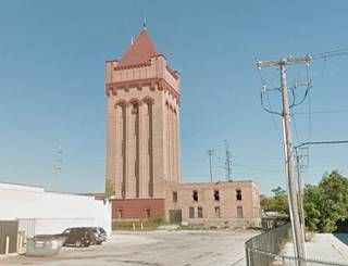
This Renaissance Revival style water tower is all that remains of the vast manufacturing plant that once stood here. Hawthorn Works was demolished in 1994.
Now it is located behind the Hawthorne Shopping Center, beside the railroad.
The complex was named after Hawthorne, a small town that was later incorporated into Cicero. It opened in 1905 and employed 45,000 workers. Its output were telephones, electrical equipment, and consumer products. It was owned by Western Electric and closed after the breakup of the Bell System as AT&T was its main customer and had suddenly vanished.
Below is a "Then and Now" sequence of this lonely tower:
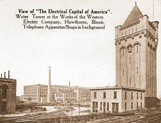
Hawthorne Works tower, vintage view, Cicero, Il. Source
South Cicero Avenue carried state Hwy 50, and Ogden was both U.S. 66 and U.S. 34; Alt U.S. 30 ran along W Roosevelt Rd. There was plenty of travelers here in the 1950s and 60s, and several motels catered to them; some have survived.
Karavan Motel
At 1620 South Cicero Avenue, Cicero, the motel dates back to the 1950s, and its paper match boxes promoted it as "A Mid-America Motel" and "A Home Away from Home" for "Luxurious Motel Living." It offered "suites for Families or Newly-Weds". Its slanting roof gives it a classic 1950's look.
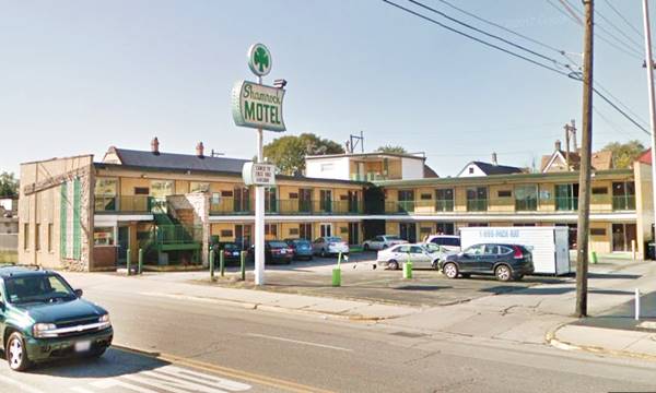
Shamrock Motel
Not far from the Karavan, is the Shamrock, at 1212 S Cicero Ave.
On the left side of the road, the motel, from the 1950s is still open. The postcard from the 1960s (stamped 1966) tells us that it had "Free Television - 24 hour switchboard service" (for the phones), that it had "Continental Breakfast" and was just "Ten minutes to Chicago's famed 'Loop'." Below is a Then and Now sequence of images.

Still the same facade combining steel grates, angled limestone and bricks. The massive neon sign and the stone column next to it have gone.
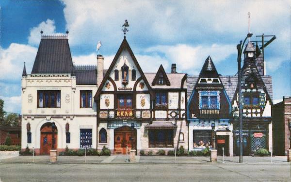
Klas Restaurant (gone)
At 5734 W Cermack Rd., this classic Czech-American fetaurant was decorated in an original Moravian style and had, according to its postcard "a distinctive Czechoslovakian atmosphere... also you will find a 14th Century Wine and Tap Room." It opened in 1922 and the building was torn down on its Centennial, in 2022.
Adolph Klas, a Bohemian immigrant started it as a lunch counter with a few tables and worked as its waiter with his wife Ella. He transformed it into a Bohemian Lodge and added rooms with different styles, Moravian, Russian, Garden -Room, etc. Adolph died in 1962 and Ella in 1966. Urban changes saw a growth of Latinos as the Czech community dwindled. The restaurant closed in 2016 and fell into disrepair. 2021 street view of it while it was still standing.
Hotel Annetta (gone)
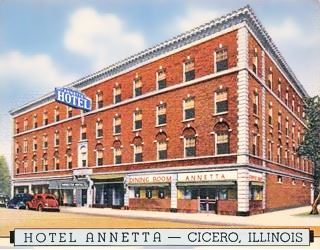
Hotel Annetta, Cicero, Il. Click for street view
This was a four-story red-brick building with 150 rooms located at 2417 S 52 nd Ave (now South Laramie Ave); its postcard tells us it was "partially air-conditioned... convenient transportation by "Elevated," surface lines and bus... Restaurant and coffee shop in connection." It was torn down in 2011, the lot lies vacant. This is a 2007 street view of it while it was still standing.
Two blocks north, at 2337 S Laramie was the Annetta Theater it opened in 1910 and could seat 800 viewers. It closed in 1951 and now is a Salvation Army community center (St. view).
This marks the end of your drive through Cicero.
Continue your Road Trip
This is the end of this leg of your Route 66 road trip through Cicero, return to Ogden Avenue and drive westwards into neighboring Berwyn.

Sponsored Content
>> Book your Hotel in Chicago

Credits
Banner image: Hackberry General Store, Hackberry, Arizona by Perla Eichenblat
Jack DeVere Rittenhouse, (1946). A Guide Book to Highway 66.


