Route 66 in Bernal NM
Index to this page
About Bernal, New Mexico
Facts, Trivia and useful information
Elevation: Elevation: 6,220 ft (1,897 m). Population: n⁄a.
Time zone: Mountain (MST): UTC minus 7 hours. Summer (DST) MDT (UTC-6).
Bernal is a small village in San Miguel County, on the west bank of Bernal Creek and south of US-85 & I-25. The historic Santa Fe Trail linked it with Santa Fe in the west, and Missouri in the east.
Bernal's History
This area has been inhabited for at least 10,000 years; and the rivers that flow south of the Sangre de Cristo Mountains, on the southeastern side of the Rocky Mountains, like Bernal Creek and the Pecos River were important trade routes for the Native American People and they were used to irrigate their crops.
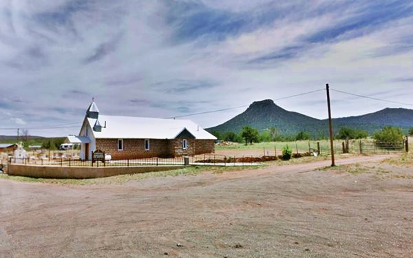
Santa Rita Chapel and Starvation Point in Bernal, NM

The initial Spanish settlement of New Mexico started in 1598 by the late 1700s it had never advanced eastwards beyond Pecos Pueblo, and Bernal Creek was further east closer to the dangerous Comanche and Apache Indians of the prairies west of the Rocky Mountains.
However, in 1794 the San Miguel del Vado Land Grant was petitioned by Lorenzo Marquez and 51 individuals, and was approved by the Spanish Governor. This was the origin of San Miguel County and several towns sprung up along the Pecos River. They faced the attacks of the Comanche and Apache but survived.
New Mexico became part of Mexico when that country became independent from Spain in 1821. But was ceded to the U.S. after the Mexican - American War (1846-8).
In his "Memoir of a tour to northern Mexico" written in 1848 Friedrich Adolph Wislizenus describes it as follows: "... passed after wards by Ojo de Bernal or San Miguel spring, surrounded by a dozen houses."
A stage coach stop on the Santa Fe Trail was built at Bernal Creek (a regular source of water that meets Pecos River to the south, near Anton Chico). The place was named after the Bernal family, as "Old Bernal", and as such appears in the 1894 USGS map, modern Bernal is located here. In Spanish it was known as an "ojo de agua" or a spring, but it was also an "arroyo" or creek.
The name: Bernal
The surname Bernal has a Sepharadic origin and means "strong as a bear". It is also written in ancient Castillian as "Vernal". In 1492 the Spanish Jews were forced to convert to Catholicism or migrate. Many came to America and settled in Mexico, and later, when the Inquisition became active there, they moved on into New Mexico.
Juan Griego was part of the Juan de Oñate expedition that occupied and settled New Mexico in 1598. Griego's wife was Pascuala Bernal. And her surname was adopted by one of their sons, starting the Bernal lineage in the territory.
Some settled along the Rio Grande River in Bernalillo (a diminutive of Bernal), others would settle at Bernal.
The Atchison, Topeka and Santa Fe Railroad built laid its tracks through the region in the early 1880s and built a station 1.5 miles east of Bernal. It was first named "Bernal" but later renamed it "Chapelle" after the Louis Chapelle who was the Archbishop of Santa Fe from 1894 to 1897.
More prosaically, the USGS map of 1884 calls it "Bernal Hill". It is topped by Glorieta Sandstone and has a truncated conical shape.
Bernal is located where the railway meets the Santa Fe Trail and takes an westerly course towards San Jose.
In 1926, Route 66 was aligned along the Santa Fe Trail from Romeroville to Santa Fe, passing through Bernal. The small village would be part of US 66 until 1937, when the Santa Fe Cut-Off shortened the highway by linking Santa Rosa with Albuquerque via Moriarty through the Tijeras Canyon and therefore bypassing this longer alignment through Santa Fe.
The 1940 New Mexico A Guide To The Colorful State published by the WPA, described the town as follows:
...First called Bernal Springs, was the first station on the Las Vegas-Santa Fe section of the old stage lines. Today it comprises only a store, gas station, and a church built around a plaza WPA (1940)

Accommodation near Bernal
There is no hotel in town, but there are plenty of lodging options for those traveling along Route 66 in some nearby towns
> > Book your room nearby in Las Vegas NM
More Lodging Near Bernal along Route 66
Below you will find a list of some of the towns along Route 66 in New Mexico. Click on any of the links to find your hotel, motel or accommodation in these towns (listed from east to west);
On Route 66's Main alignment
The Santa Fe Route 66 segment
Eastwards
Westwards
>> There are RV campgrounds near Bernal in Las Vegas NM
The weather in Bernal

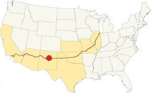
Location of Bernal on Route 66
This is a dry region with warm summers and cold winters.
The average summer high (Jul) is 83°F (28.3°C) and the low average is 52°F (11.1°C). In winter (Jan) the average low and high are: 22°F (-5.5°C) and 46°F (7.8°C) respectively.
Rainfall is higher during the period between May and Nov. (13 in. - 330 mm). The average rainfall is 16.5 in. per year (419 mm).
There are around 272 sunny days and about 62 precipitation days per year. Snowfall is around 27 in. per year, and falls between Nov. and March.
Tornado risk
Bernal is located in an area with virtually no tornado risk: San Miguel county only has two (2) Tornado watches per year and mostly in the eastern fringe of the county.
Tornado Risk: read more about Tornado Risk along Route 66
Map of Route 66 in Bernal, NM
The navy blue line in our custom map shows the alignment of US 66 across Bernal.
The original Route 66 was aligned through Santa Fe in 1926 along three previous highways, the "Ozark Trail", the "Santa Fe Trail" and the "National Old Trails".

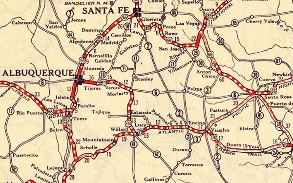
1925 Road map, Central NM
Click on image to enlarge.
Source
The thumbnail map printed in 1925 (click on it to see the full sized map) shows the roads that existed one year before Route 66 was created.
Notice "Bernal" on the center-right side of the map.
Those marked "22" (National Old Trails Rd., coming from Los Angeles) and "32" (New Santa Fe Rd.) with white letters in a black box, went from Gallup to Albuquerque and through Santa Fe.
The only paved sections (full black line) were between Albuquerque and Bernalillo, and Albuquerque and Tijeras. The highway from Bernalillo to Santa Fe, and beyond Isleta was "improved" (dashed line), the rest were either graded or dirt roads.
The Santa Fe Loop (1926 - 1937)
This was the first alignment of Route 66, from Santa Rosa to Albuquerque via Pecos to Santa Fe.
We describe this segment in our Santa Fe Loop page, a dedicated webpage, with the full alignment, from Santa Rosa, through Dillia, Pecos, Santa Fe, Santo Domingo, and Bernalillo all the way to Albuquerque.
This original highway also continued beyond Albuquerque to Isleta, Peralta and Mesita.
Bernal does not appear in this map

1937 Realignment of Route 66
A political dispute between New Mexico Governor A. T. Hannett and local politicians led to the realignment of Route 66 in 1937.
Hannett blamed the local party bosses when he lost his 1927 bid to re-election. He decided to punish them, and their backers (the business men in Santa Fe) so he quickly had state highway #6 built, in 1927, to link Moriarty with Albuquerque. This highway bypassed the capital city, and was 90 miles shorter for those driving from the east to Albuquerque.
In 1937, the Federal roadbuilders decided to realign Route 66 using Hannett's road, and paved it. It was a straighter highway, and only had a short mountain segment across the Sandia Mountains between Sedillo, Tijeras and Carnuel.
Route 66 Alignment near Bernal
With maps and full information of the alignments of Rte. 66.
- Albuquerque to Lupton (next)
- Santa Rosa to Albuquerque 1937-85 (parallel)
- Tucumcari to Santa Rosa (previous)
The Santa Fe Loop (1926 - 1937)
Our Santa Fe Loop page describes the complete 1926 to 1937 alignment of Route 66 from Santa Rosa to Albuquerque through Pecos, Santa Fe and Bernalillo.
Bernal: its Attractions
Landmarks, Route 66 sights
The Santa Fe Trail
This was a very important route or trail opened in the 1792 across the Sangre de Cristo Mountains and the Great Plains that linked Santa Fe with the French Louisiana settlements on the Missouri River (now St. Joseph and Independence MO). It was known as the "Santa Fe Trail".
It was an key route for the wagon trains that moved goods into New Mexico and many settlers used it to reach California and the Southwest.
After the 1820s more traffic flowed along it, but it became safer to use after the 1846-48 war as the American army neutralized the Indian threat- Wagon trains used it to move goods from the east into New Mexico, and later, pioneers trekked along it to settle in California and the Southwest of the U.S.
Upon reaching New Mexico the trail split into two forks to reach Santa Fe, one of them went through Las Vegas, Bernal, and Pecos.
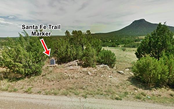
Santa Fe Trail Marker
The Daughters of the American Revolution placed several granite monuments along the Santa Fe trail, there is one in Bernal, and it is located on the eastern side of town: at the intersection of the road from Exit 330A and Hwy B26A (the original Route 66 alignment), roughly 50 yards east, on the south side of the highway, it is pictured below (red arrow) notice Starvation Peak in the distance.

The trail later became part of the US highway system in 1926 when Route 66 and US 85 were aligned along it. Later in 1937 Route 66 moved to a new alignment from Santa Rosa to Albuquerque, but U.S. highway 85 (and the I-25 Interstate) use the old roadbed and are kown as the "CanAm Highway."
Starvation Peak
This mountain (Street view) was a natural landmark for those riding along the Santa Fe Trail. It is just south of Bernal (7,031 ft - 2.143 m) and its original name is Bernal Hill.
The popular name evokes the legend of a group of 120 Spanish men, women, and children driven up the hill by the natives during the 1680 Pueblo Revolt. Under siege, they starved to death. A penitente cross marks its highest point. This peak was a landmark for Santa Fe Trail travelers.
Capilla de Santa Rita de Cascia
Head east along the old US 66 for 1,000 feet and to your right, on the Southwest corner at the intersection B26A and B28A is the old store-gas station (the base of the concrete pumps island survives in front of it).
Next to it, is the small Chapel of Santa Rita de Cascia was built in 1916 in stone. Its name honors an Italian nun (1381 - 1457), who died in Cascia, Italy and is the Patron saint of the impossible and helps those in need.
The chuch has three belfries on its gabled roof, but only one bell. The cemetery is on the south side of the church.
Head west along County Road B26A and reach "Serafina":
Serafina
Elevation: 6,204 ft (1,891 m) Population: n⁄a.
The post office opened in Bernal in 1923 but as there already was a post office named Bernal in New Mexico it had to adopt another name. The local postmaster, Basilio Griego chose his daughter's name: "Serafina". It became a small non-incorporated village just west of Bernal.
Serafina is femenine for Seraphim, a biblical name that means glowing, burning; it is a celestial being like an angel.
End of this leg of your Road Trip
Here on in Bernal is the end of this leg of your journey. Continue your road trip by heading west to your next stop on your road trip: San Jose.
Sponsored Content

>> Book your Hotel in Albuquerque

Credits
Banner image: Hackberry General Store, Hackberry, California by Perla Eichenblat


