Route 66 in San Jose NM
Index to this page
About San Jose, New Mexico
Facts, Trivia and useful information
Elevation: Elevation: 6,109 ft (1,862 m). Population: 882 (2025).
Time zone: Mountain (MST): UTC minus 7 hours. Summer (DST) MDT (UTC-6).
San Jose is a small village in San Miguel County, on the west bank of the Pecos River and south of US-85 & I-25. The historic Santa Fe Trail linked it with Santa Fe.
History
New Mexico has been inhabited for the last ten millennia and the rivers running south of the Sangre de Cristo Mountains such as the Pecos River that flows by San Jose, were key communication routes between the mountains and the Plains to the East. The natives used the water to irrigate their crops.
Historic San Jose Church in San Jose del Vado, NM
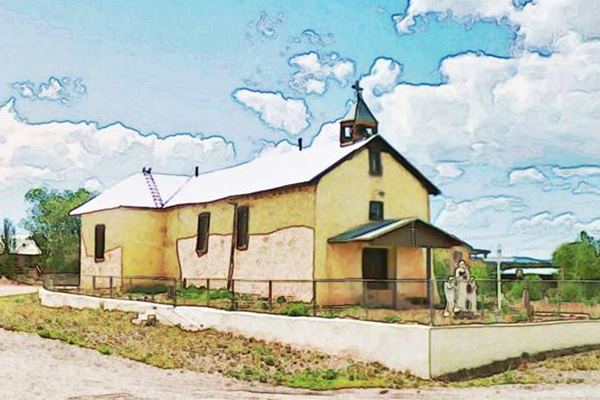
The Spanish occupied New Mexico during the expedition led by Juan de Oñate in 1589, but did not advance further east than Pecos Pueblo. The "Old Pecos Route" along the Pecos River had been used by the Coronado expedition in 1540 and by the Pueblo people to trade with the Natives that lived further south.
In 1794 the San Miguel del Vado Land Grant was petitioned by Lorenzo Marquez and was approved by the Governor. This was the origin of the town of San Miguel south of San Jose. Nine years later these Spanish settlers had established a second fortified settlement further north, on the Pecos River, which they named San Jose del Vado (Saint Joseph of the Ford), as it was a place where the Pecos river could be forded. The senior Alcalde of Santa Fe distributed land to the 47 settlers on March 15, 1803. San Jose had been born.
The name: San Jose
It is the Spanish name of Saint Joseph, the husband of the Virigin Mary. A popular name among Catholics in Spanish America. The "del Vado" part of the name means "of the ford", alluding to a favorable point for crossing the Pecos River.
The town was built with a central square or Plaza, where a church was erected in 1826, San Jose church, surrounded by sturdy adobe homes built closely to each other, like an enclosing wall. The Pecos river to the east added a natural barrier to deter the attacks of the Comanche and Apache Indians. There was another creek on the north side of the community.
In 1821, New Mexico became part of Mexico when it won its independence from Spain and a stage stop was established there on the Santa Fe Trail in 1822.
The territory change hands again in 1848 after the U.S. won the Mexican-American War (1846-8). San Miguel became a county in the New Mexican Territory in 1852.
When the Atchison, Topeka and Santa Fe Railroad built the railway through the area, it set up a station at San Miguel and another north of San Jose, at Sands, leaving the town without a stop. The train caused traffic to fall along the Santa Fe trail and San Jose remained in a state of hibernation that preserved intact, its nineteenth century appeal.
San Jose Trivia
It was very popular on the annual St. Joseph fair when "La corrida del Gallo" took place. This was a "chicken pull", where horsemen fought against each other to pluck a partly buried live cock from the ground and get the poor creature back to the starting line dead or alive.
General Stephen Kearny camped here during his march to occupy Santa Fe in 1846, during the Mexican American War.
Route 66 was created in 1926 and it was aligned together with US 85 along the Santa Fe Trail from Romeroville to Santa Fe. It passed through the town of San Jose. In 1933, Route 66 was realigned on the north side of the town, straightening its alignment and bypassing San Jose. In 1937 the whole alignment was bypassed by one running from Santa Rosa to Albuquerque.

Accommodation near San Jose
There are lodging options for those traveling along Route 66 in some nearby towns:
> > Book your room nearby in Santa Fe or Las Vegas NM
Lodging Near San Jose along Route 66
Below you will find a list of some of the towns along Route 66 in New Mexico. Click on any of the links to find your hotel, motel or accommodation in these towns (listed from east to west):
On Route 66's Main alignment
The Santa Fe Route 66 segment
Eastwards
Westwards
>> There are RV campgrounds near San Jose in Las Vegas NM
The weather in San Jose
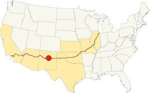
Location of San Jose on Route 66
The climate in San Jose is hot in summer and cold in winter. It is relatively arid and has very dry air.
The average high in summer (July) is 86°F (30°C) and the average low is 53°F (11.7°C). During winter (Jan) the average high is 48°C (8.9°C) and the average low is 21°F (-6.1°C), below freezing point.
Snowfall reaches 25 inches (63.5 in.) on average and can fall at any time between November and April. Most falling during Dec. and Jan (6 in. each). Rainfall is 17.2 in. per year (437 mm). The rainiest months are June through Sept. with almost 10 inches of rain.
Tornado risk
San Jose is located in an area with virtually no tornado risk: San Miguel county only has two (2) Tornado watches per year and mostly in the eastern fringe of the county.
Tornado Risk: read more about Tornado Risk along Route 66
Map of Route 66 in San Jose, NM
Visit our The Santa Fe Loop (1926-37) alignment page for a detailed description of Route 66 in this area. Below is the color coded interactive map:
>> Custom map of Route 66 in town
The navy blue line in our custom map shows the 1926-33 alignment of US 66 across Bernal; the pink line in that map is the cutoff that bypassed San Jose after 1933..
The original Route 66 was aligned through Santa Fe in 1926 along three previous highways, the "Ozark Trail", the "Santa Fe Trail" and the "National Old Trails".

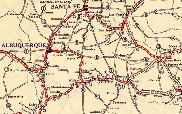
1925 Road map, Central NM
Click on image to enlarge.
Source
The thumbnail map from 1925 (click on it to see the full sized map) shows the roads that existed one year before Route 66 was created.
Notice "San Jose" on the center-right side of the map.
Those marked "22" (National Old Trails Rd., coming from Los Angeles) and "32" (New Santa Fe Rd.) with white letters in a black box, went from Gallup to Albuquerque and through Santa Fe.
The only paved sections (full black line) were between Albuquerque and Bernalillo, and Albuquerque and Tijeras. The highway from Bernalillo to Santa Fe, and beyond Isleta was "improved" (dashed line), the rest were either graded or dirt roads.
Further down we describe the old alignment in San Jose
The Santa Fe Loop (1926-1937)
This was the first alignment of Route 66, from Santa Rosa to Albuquerque via Pecos to Santa Fe.
We describe this segment in our Santa Fe Loop page, a dedicated webpage, with the full alignment, from Santa Rosa, through Dillia, Pecos, Santa Fe, Santo Domingo, and Bernalillo all the way to Albuquerque.
This original highway also continued beyond Albuquerque to Isleta, Peralta and Mesita.
1937 Realignment of Route 66
A political dispute between New Mexico Governor A. T. Hannett and local politicians led to the realignment of Route 66 in 1937.
Hannett blamed the local party bosses when he lost his 1927 bid to re-election. He decided to punish them, and their backers (the business men in Santa Fe) so he quickly had state highway #6 built, in 1927, to link Moriarty with Albuquerque. This highway bypassed the capital city, and was 90 miles shorter for those driving from the east to Albuquerque.
In 1937, the Federal roadbuilders decided to realign Route 66 using Hannett's road, and paved it. It was a straighter highway, and only had a short mountain segment across the Sandia Mountains between Sedillo, Tijeras and Carnuel.
Route 66 Alignment near San Jose
With maps and full information of the alignments of Rte. 66.
- Albuquerque to Lupton (next)
- Santa Rosa to Albuquerque 1937-85 (parallel)
- Tucumcari to Santa Rosa (previous)
The Santa Fe Loop (1926-1937)
Our Santa Fe Loop page describes the complete 1926 to 1937 alignment of Route 66 from Santa Rosa to Albuquerque through Pecos, Santa Fe and Bernalillo.
San Jose's Attractions
Sights and things to see
Drive west from Bernal and enter San Jose as shown in this map with directions. The main street, B41D is the 1926-33 alignment of Route 66 on the western side of San Jose.
The road meets the town's main plaza and curves around it, by the old church.
Plaza
The square was enclosed in the 1840s or 1850s with a wall and new buildings around the church.
San Jose Church
Located on San Jose Plaza, this church was built in 1826 and is one of the oldest in the area. It is dedicated to the Patron Saint of the village, St. Joseph.
The area to the east of the church, in the atrium was the "Camposanto" or cemetery.
The Historic Santa Fe Trail
The Santa Fe Trail was opened in 1792 to link the town of Santa Fe, in the Spanish Nueva Mexico with the French trading posts on the Missouri River. Indian raids in the Great Plains made this enterprise dangerous. Later during the 1820s and 40s, wagon trains used it to move goods into New Mexico. It was also one of the routes chosen by the settlers used it to reach California and the Southwest.
The southern fork of the Trail passed through Las Vegas, San Jose, Pecos and crossed Glorieta Pass to reach Santa Fe.
Route 66 meets the "Old Santa Fe Trail"
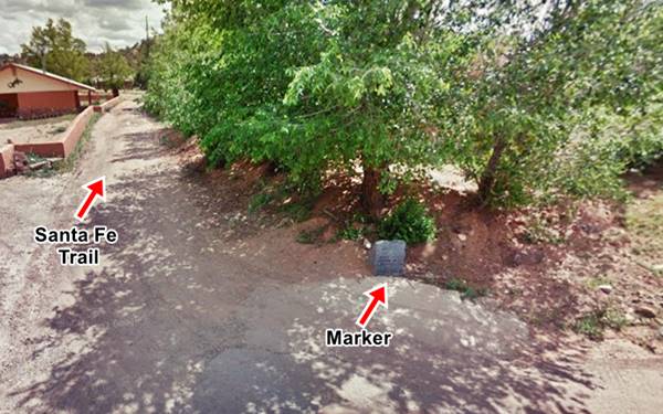
The village of San Jose is one of the oldest in the area, dating back to 1803. It was a stop on the "Santa Fe Trail" that entered the town as shown in map coming from San Miguel del Vado, along Camino Casa Grande. On the corner of this street and old Route 66, one block east of the plaza, is a granite monument commemorating the Santa Fe trail placed by the Daughters of the American Revolution (map marking the spot).
The Old Route 66 Steel Bridge
Head east from the Plaza (Square) along Co. Rd. B41D for 0.3 miles, and the road (Old Route 66) will end right next to a closed steel truss bridge, the original 1926 Bridge of Route 66 across the Pecos River. It was built around 1923 and has a asphalt covered timber deck. The road was paved here in 1932. See picture below.
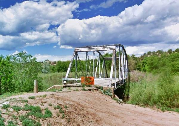
The highway curves west and then north, crosses the arroyo San Jose creek on the north side of the town (also built in 1923), and heads up the valley and then turns west again.
>> navy blue line in our custom map is ths 1926-32 San Jose alignment. Pale blue marker: steel bridge
The original US 66 Alignment in San Jose
The highway continued on the eastern side of the river and met the current North Frontage Rd. You can still see part of this alignment as you approach the village, along the North Frontage Road coming from Bernal: the original 1926-33 roadway forks to the left (map showing the spot), this dirt surfaced trail runs south and is now cut by I-25 so it doesn't reach San Jose. Below is a view looking north towards the North Frontage Rd. from the Freeway showing this trail (click to enlarge).
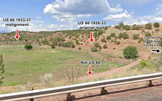
US 66 (1926-33) alignment near San Jose
Click on image to enlarge. St view
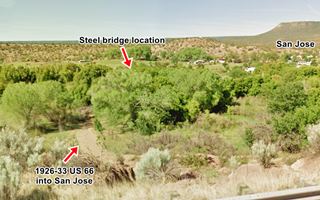
US 66 (1926-33) alignment near San Jose
Click on image to enlarge. St view
It resurfaces on the south side of the freeway (image above-click to enlarge it), and it runs south and curves at the Pecos River to cross it using the steel bridge.
Head back along B41D and leave the village. When you reach the North Frontage Road of I-25, take a left. This is the alignment of the old U.S. 66, Ahead it goes through Sands.
Sands
The railway depot that was built to the north of San Jose was named Sands (the place was also known as McPherson), but the post office was called Soham and it opened in 1893. It is a small village 3⁄4 of a mile north of I-25. The Pecos River runs along its northern side.
End of this leg of your Road Trip
Sands marks the the end of this leg of your journey. Continue your road trip by heading west to your next stop on your road trip: Ilfeld.

Sponsored Content

>> Book your Hotel in Albuquerque

Credits
Banner image: Hackberry General Store, Hackberry, California by Perla Eichenblat

