Route 66 in Rowe NM
Index to this page
About Rowe, New Mexico
Facts, Trivia and useful information
Elevation: Elevation: 6,821 ft (2,079 m), Population: n⁄a.
Time zone: Mountain (MST): UTC minus 7 hours. Summer (DST) MDT (UTC-6).
Rowe is an unicorporated community in San Miguel County, New Mexico
History
See neighbouring San Jose, for the history of New Mexico during the prehispanic and Spanish Colonial period (further down we mention the Rowe Pueblo Ruins).
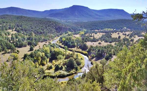
The Santa Fe Trail linked Rowe with Pecos and San Jose, as an active trade route.
The first store in Rowe was owned by Andrew Kosloskie, and he supplied the stage coaches along the Santa Fe Trail. He chose the spot because there was a good spring.
The Union forces retreated here after their first skirmish at Glorieta Pass (1862) and set up headquarters in Rowe.
The Atchison, Topeka and Santa Fe Railroad built the railway beside the Santa Fe Trail in the 1880s and chose the spot which had been first settled in 1876 for a depot. A post office was created there in 1884. Its original name in 1883 was Kingman, but later it was renamed after a contractor of the Atchison, Topeka and Santa Fe Railroad who had built it as a work camp for the construction of the railway: Mr. Rowe.
Most of its residents came from the nearby village of Las Ruedas on Pecos River, who moved to the new stop beside the railroad. The old Las Ruedas (Spanish for "Wheels") townsite is now private property.
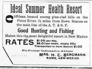
1909 ad of a Summer Health Resort in Rowe. Source
Bergmann opened a Summer Health Resort, "Cliffene", just 21⁄2 miles from the town in the early 1900s. It had "Good hunting and fishing" and the rates were $1.50 per day or $8.00 per week, with meals at 50¢.
In 1926 Route 66 was aligned through Rowe and remained so until 1937 when it was realigned further south, between Moriarty and Santa Rosa, bypassing all the towns along the Santa Fe Loop including Rowe. Now US 85 and I-25 run past its eastern side.

Accommodation near Rowe
There are no hotels in Rowe, but there are plenty of lodging options for those traveling along Route 66 in some nearby towns
> > Book your room nearby in Santa Fe or Las Vegas NM
More Lodging Near Rowe along Route 66
Below you will find a list of some of the towns along Route 66 in New Mexico. Click on any of the links to find your hotel, motel or accommodation in these towns (listed from east to west):
On Route 66's Main alignment
The Santa Fe Route 66 segment
Eastwards
Westwards
>> There are RV campgrounds near Rowe in Las Vegas NM
The weather in Rowe
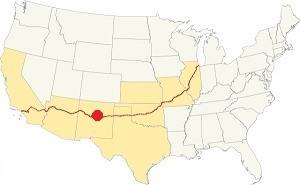
Location of Rowe on Route 66
The climate is hot in summer and cold in winter. It is relatively arid and has very dry air.
The average high in summer (July) is 86°F (30°C) and the average low is 53°F (11.7°C). During winter (Jan) the average high is 48°C (8.9°C) and the average low is 21°F (-6.1°C), below freezing point.
Snowfall reaches 25 inches (63.5 in.) on average and can fall at any time between November and April. Most falling during Dec. and Jan (6 in. each)Rainfall is 17.2 in. per year (437 mm). The rainiest months are June through Sept. with almost 10 inches of rain.
Tornado risk
Rowe is located in an area with virtually no tornado risk: San Miguel county only has two (2) Tornado watches per year and mostly in the eastern fringe of the county.
Tornado Risk: read more about Tornado Risk along Route66.
Map of Route 66 in Rowe, NM
Visit our The Santa Fe Loop (1926-37) alignment page for a detailed description of Route 66 in this area. Below is the color coded interactive map:
>> Custom map of Route 66 in town
The red line in our custom map shows the alignment of US 66 across Rowe.
The original Route 66 was aligned through Santa Fe in 1926 along three previous highways, the "Ozark Trail", the "Santa Fe Trail" and the "National Old Trails".

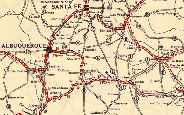
1925 Road map, Central NM
Click on image to enlarge.
Source
The thumbnail map from 1925 (click on it to see the full sized map) shows the roads that existed one year before Route 66 was created.
Notice "Rowe" on the center-right side of the map.
Those marked "22" (National Old Trails Rd., coming from Los Angeles) and "32" (New Santa Fe Rd.) with white letters in a black box, went from Gallup to Albuquerque and through Santa Fe.
The only paved sections (full black line) were between Albuquerque and Bernalillo, and Albuquerque and Tijeras. The highway from Bernalillo to Santa Fe, and beyond Isleta was "improved" (dashed line), the rest were either graded or dirt roads.
The Santa Fe Loop (1926-1937)
This was the first alignment of Route 66, from Santa Rosa to Albuquerque via Pecos to Santa Fe.
We describe this segment in our Santa Fe Loop page, a dedicated webpage, with the full alignment, from Santa Rosa, through Dillia, Pecos, Santa Fe, Santo Domingo, and Bernalillo all the way to Albuquerque.
This original highway also continued beyond Albuquerque to Isleta, Peralta and Mesita.
Rowe figures in this map
1937 Realignment of Route 66
A political dispute between New Mexico Governor A. T. Hannett and local politicians led to the realignment of Route 66 in 1937.
Hannett blamed the local party bosses when he lost his 1927 bid to re-election. He decided to punish them, and their backers (the business men in Santa Fe) so he quickly had state highway #6 built, in 1927, to link Moriarty with Albuquerque. This highway bypassed the capital city, and was 90 miles shorter for those driving from the east to Albuquerque.
In 1937, the Federal roadbuilders decided to realign Route 66 using Hannett's road, and paved it. It was a straighter highway, and only had a short mountain segment across the Sandia Mountains between Sedillo, Tijeras and Carnuel.
Route 66 Alignment near Rowe
With maps and full information of the alignments of Rte. 66.
- Albuquerque to Lupton (next)
- Santa Rosa to Albuquerque 1937-85 (parallel)
- Tucumcari to Santa Rosa (previous)
The Santa Fe Loop (1926-1937)
Our Santa Fe Loop page describes the complete 1926 to 1937 alignment of Route 66 from Santa Rosa to Albuquerque through Pecos, Santa Fe and Bernalillo.
Rowe: its Attractions
Landmarks, Route 66 sights
Drive westwards from Ilfeld towards Rowe. The book, "New Mexico: A Guide to the Colorful State" published in 1940 by the Works Progress Administration or WPA, describes the scenery as follows:
West of San Jose the highway winds over gently undulating country; small ranches, usually perched on the higher spots, break the monotony of the terrain. The land is channeled by the inevitable arroyo, carved out of the brown and gray shales that make up the surface to the north. To the south (L) is the main part of Glorieta Mesa, a tableland of gray sandstone that extends to the Sangre de Cristo Range. This mesa presents a continuous line of cliffs with a level sandstone-capped crest which descends to the valley of the Pecos.
At ROWE, 152 m. route follows Alt. US 85, right. WPA (1940)
Gross, Kelly & Co. store
There was a store in town, owned by Gross, Kelly and Company. The business was established by H. W. Kelly and Jacob Gross in Kansas in 1869 and they built trading warehouses along the railroad. They expanded into Colorado and New Mexico in the 1880s and in this area had stores in Pecos, Las Vegas, Santa Fe and Rowe.
stablished warehouses at key distribution points along the railroad lines, advancing into Colorado and by 1880 into New Mexico.
This store opened in 1910 and closed in 1947. Then it changed hands and remained open until the 1960s.
Notice the group on the left fixing a flat tire:
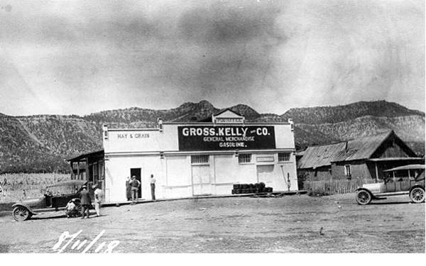
By the mountains behind it, with the "picacho" peak the image looks westwards, and the probable site of this store was by the railway depot (it burned down in the 1970s) between the tracks and Route 66. See this St. view and notice the same mountains outline in the background.
Rowe's Sagrada Familia Church
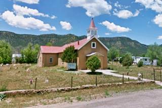
Here, in downtown Rowe, take a right along County Rd. B62, and ahead, to your left is the old Holy Family (Sagrada Familia) church with a cemetry on its southern side.
Padilla's Store
Return to the highway and just ahead, to your right is the former grocery store facing Route 66 with some ghost advertising signs fading on its walls.
View of Rowe E. T. Padilla's store on the Old 1926 Route 66-Rowe, New Mexico
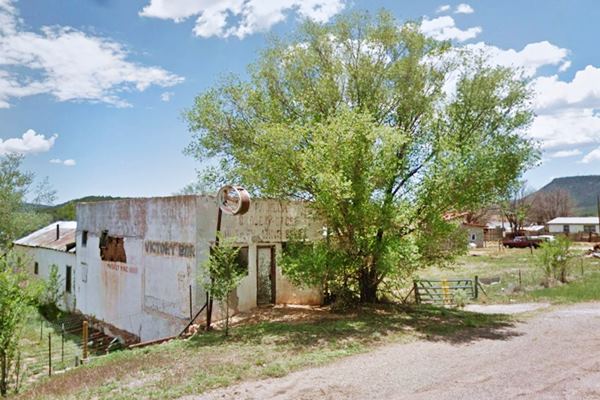
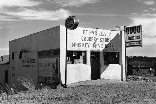
The highway heads leaves Rowe, curving to the east (it always had this course, even before the freeway was built). After crossing the freeway it becomes NM 63. Here you can take a short side trip to visit Rowe Pueblo, or head north, towards Pecos and visit the final landmark near Rowe, a historic spot on the Santa Fe Trail, Koslowski's Ranch.
Rowe Pueblo archaeological Site
Side trip (0.9 mi. map with directions)
The pueblo was occupied between AD 1240s and AD 1390s and it is located bretween US-85 on the west, the Pecos River on the east. It lies on private property and was excavated in 1917, 1970s, 1980, 83 and 1984 by the University of New Mexico Summer Field School under the direction of Linda Cordell.
It consists of a three plaza pueblo which had many two-story buildings, now collapsed. It followed a rectangular layout. The inhabitants moved to Pecos Pueblo, 4 mi (6.4 km) further north perhaps because it offered better defenses against other more aggressive native groups.
It is in the field shown in this St. view. Close to the townsite of Las Ruedas
Etiquette at an Archaeological Site
Leave no trace, only take photographs. Remember that cultural sites are degraded by unintentional damage caused by visitors. View from a distance to reduce impact. Leave artifacts where they lie (potsherds, flints). Don't move rocks, branches. Don't touch plaster walls. Don't touch rock art. Don't climb on walls or roofs. Pets should not enter archaeological sites.
Archaeological sites are protected by local, federal and state laws and they provide for prosecution with fines and⁄or imprisonment of violators.
Koslowski's Ranch
A Pole, Martin Kozlowski (1827-1905) established a hostel on the Santa Fe Trail in 1858, and catered to those traveling along it.
The Historic Santa Fe Trail
The Spanish settlers in Santa Fe opened the "Santa Fe Trail" in 1792 to link their city with the French trading posts in Louisiana, on the Missouri River.
Much later, the wagon trains used it to move merchandise to and from New Mexico. It was also one of the main trails used by the settlers to reach the Southwest and the coast of the Pacific Ocean.
The southern fork of the Trail passed through Las Vegas, Rowe, Pecos and crossed Glorieta Pass to reach Santa Fe.
During the American Civil War, the Union forces camped on Kozlowski's property and used his Inn as a hospital (1862). After the war, Kozlowski opened a trading post. It also served as a stop for the Sanderson and Barlow stagecoach service along the Santa Fe Trail. There was a permanent spring 300 yards from the ranch house and it watered the horses and guests.
The arrival of the railroad in the 1880s reduced the flow of tavelers along the Trail and business at Koslowski's suffered. U.S. Army Colonel Henry Inman wrote about the ranch in 1898 recalling a visit he made in 1885 and how the place had decayed:
Thirteen years ago I revisited the once well-known Kosloskie's Ranch, a picturesque cabin at the foot of the Glorieta Mountains, about half a mile from the ruins on the Rio Pecos. The old Pole was absent, but his wife was there; and, although I had not seen her for fifteen years, she remembered me well, and at once began to deplore the changed condition of the country since the advent of the railroad, declaring it had ruined their family with many others. I could not disagree with her view of the matter, as I looked on the debris of a former relative greatness all around me. I recalled the fact that once Kosloskie's Ranch was the favourite eating station on the Trail; where you were ever sure of a substantial meal—the main feature of which was the delicious brook trout, which were caught out of the stream which ran near the door while you were washing the dust out of your eyes and ears.
The trout have vacated the Pecos; the ranch is a ruin, and stands in grim contrast with the old temple and church on the hill; and both are monuments of civilizations that will never come again.
Weeds and sunflowers mark the once broad trail to the quaint Aztec city, and silence reigns in the beautiful valley, save when broken by the passage of "The Flyer" of the Atchison, Topeka, and Santa Fe railway, as it struggles up the heavy grade of the Glorieta Mountains a mile or more distant. Henry Inman, The Old Santa Fe Trail, The Story of a Great Highway (1898)
In 1898 Martin deeded the ranch and post to his son Thomas and moved to Albuquerque. Thomas lost it in 1925 due to non-payment of owed taxes. The U.S. government repossessed the land and granted it to Tex Austin, a rodeo entrepreneur who renamed it "Forked Lightning Ranch".
The image below shows it at this time, notice US 66, dirt surfaced, to the left, the Glorieta Creek bridge ahead, and the ranch and trading post to the right:
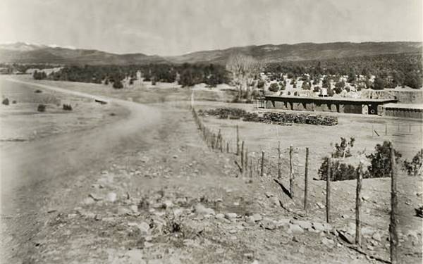
See this same view nowadays with a paved Old Route 66 running past the ranch. Same spot almost 100 years later!
Austin turned it into a dude ranch and built a new ranch house on the spot where Glorieta Creek meets the Pecos river. He kept the original trading post as a store and facilities for the foreman.
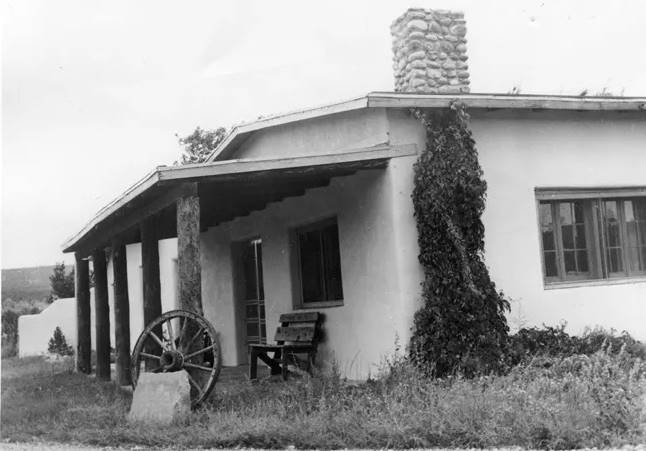
1957 view of Kozlowski's Trading Post. Source
The Great Depression hurt Austin's finances and he ceded it to his creditors in 1935. In 1941 a rich Texan oilman, E.E. Fogelson bought it. He married Hollywood star Greer Garson in 1949 and increased the holdings of the ranch to 13,000 acres. They both spent time on the ranch with guests and friends at the new ranch house, but they also upkept the historic Kozlowski Trading Post and ranch house.
When Fogelson died in 1987, his son inherited the southern half, and Greer Garson the northern part. GArson sold it in 1991 to The Conservation Fund who in turn donated it to the National Park Service. Now it is part of the Pecos National Historical Park.
The old Trading post and Ranch nowadays
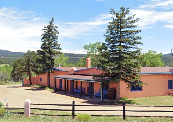
End of this leg of your Road Trip
Here on at the old trading post on Glorieta Creek, is the end of this leg of your journey. Continue your road trip by heading west to your next stop on your road trip: Pecos.

Sponsored Content

>> Book your Hotel in Albuquerque

Credits
Banner image: Hackberry General Store, Hackberry, California by Perla Eichenblat
Rowe Ruin Pecos Conference Field Tour


