Route 66 Road Trip in Benld:
Index to this page
All about Benld, Illinois
Trivia, Facts and Useful Information
Elevation: 620 ft (190 m). Population 1,403 (2024).
Time zone: Central (CST): UTC minus 6 hours. Summer (DST) CDT (UTC-5).
Benld is a city located in Macoupin county, Illinois on the 1926-30 Route 66 alignment.
The History of Benld
People have been living in what nowadays is the state of Illinois for over 11,000 years, since the last Ice Age ended. Later, when the first European explorers (French, coming from Canada) reached the area, they encountered the Illinoisian Indians. This took place in the 1600s.
The territory was ceded by France to England after the Seven Year War in 1763, and after the American Independence it became a Territory of the U.S.A, it was admitted into the union as the state of Illinois in 1818.
The first settler in the region was John Woods, who came from Virginia in 1817. Macoupin County was established in 1829 and was named after Macoupin Creek (the word is a Miami-Illinois term for the American lotus Nelumbo lutea).
It was a farming area until Mr. Dorsey, an early settler platted the town (he also had the coal mining rights) in the late 1880s. It was formally founded in 1903 and the post office opened in 1904.
The name Benld
The name combines the letters from the town's founder's name: Benjamin L. Dorsey.
Route 66 was aligned through the city following the frist State Highway, SBI 4, in 1926, but it was short lived as in 1930 it was shortened and made straighter, realigned to the east through Litchfield, bypassing Benld.

Hotels and Motels in Benld
Lodging & accommodation in Benld; sponsored content. Find a room in neighboring Staunton, just a few miles to the south:
> > Book your hotel nearby, in Staunton or Springfield
More Accommodation near Benld on Route 66
Below you will find a list of some of the towns along Route 66 east and west of this town; click on any of the links to find your accommodation in these towns (shown from east to west):
Along Route 66 in IL
- Hotels in Illinois
- Route 66 Starting point ▸ Chicago
- Lockport
- Willowbrook
- Bolingbrook
- Plainfield
- Romeoville
- Joliet
- Wilmington
- Dwight
- Pontiac
- Chenoa
- Normal
- Bloomington
- Atlanta
- Lincoln
- Springfield
- Raymond
- Litchfield
- Staunton
- Williamson
- Hamel
- Edwardsville
- Collinsville
- Troy
- Glen Carbon
- Pontoon Beach
- Granite City
- East St. Louis
West in Missouri
- Hotels in Missouri
- Florissant MO
- Bridgeton MO
- St. Louis MO
- Kirkwood MO
>> Check out the RV campground nearby in Douglas
The weather in Benld
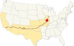
Location of Benld on U.S. Hwy. 66, Illinois
Benld has a "humid continental" climate with wet and hot summers (which are quite long) and short but very cold winters -with plenty of snow and bitter wind.
The average temperature is 52.4 °F (11.3°C). The average winter temperatures (Jan) are: low 21°F (-6°C) and high 35°F (1.7°C). The summer averages (Jul) are: high 86°F (30°C), and low: 68°F (20°C).
In Benld snow may fall for over four months with an average 22 inches (56 cm) of snowfall yearly. Rainfall averages some 35.2 in. (893 mm) yearly.
Tornado risk
The countryside near Benld is hit by some 7 tornados per year. Tornado Risk: learn more about the Tornado Risk on US 66.
Map of the 1926-30 Route 66 through Benld
After leaving Gillespie the higheway ran south in a straight line towards Benld; see the orange line in our custom map.
The highway took two sharp turns when it reached Benld along "North Hardroad" and grazed the western side of the city. The later "South Hardroad" was built after 1930 and never carried Route 66 (map with this alignment - see the orange line in our custom map). Then it ran straight southwards to Sawyerville and onwards to Staunton (burgundy color line).
South of Benld, the Staunton Country Club missing road
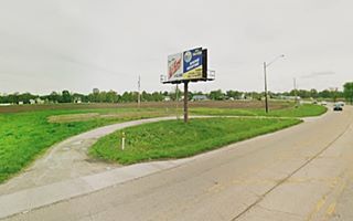
As you can see in this 1973 aerial photo there is an original segment of highway on the southeastern side of the highway at Country Club lane - Gipsy Lane. The railroad crossing has been eliminated so it has dead ends on both streets. We marked it in our custom Route 66 map with a violet line. Don't miss the ghost paving on its northern tip next to the golf course (pictured). From here it went into Staunton, the last town on the 1926-30 alignment.
The Route 66 alignment in Benld
Visit our pages with old maps and plenty of information about US 66's alignments.
- Route 66 Hamel IL to St. Louis MO (Next)
- Springfield to Staunton IL (1926-30 US66 near Benld)
- Springfield to Hamel IL (1930-77 US66 to the east of Benld)
- Route 66 Pontiac to Springfield IL (Previous)

Benld: classic US 66 Sights
Landmarks and Attractions
Gas For Less site (gone)
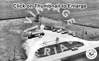
Approaching Benld from Gillespie you will reach the sharp 90° turn eastwards along North Hardroad, the original US66 (map with directions). The later 1930s Route 66 followed the current I-4 into Benld, a straighter alignment with softer curves. Here, just 400 ft. south of the junction of Routes 4 and 138 is the site of the "Gas For Less" station to your left. Click on the 1967 aerial photo thumbnail below to see a full sized image (It looks east, Benld is to the right, Gillespie to the left). All that remains is the curved drive access (image below).
Drive east the original US66 and it turns sharply to the south and heads into Benld. Ahead is a Route 66 wayside kiosk and statue:
Route 66 statues and kiosk
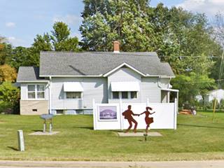
At the southern tip of the N Hardroad segment, where it ends at West Walnut St., and you merge with I-4 once again is the shilouette.
To your left, on the SE corner of the intersection, the kiosk has a steel shilouette depicting two 1950s dancers enjoying themselves at the now gone Coliseum Ballroom. The place burned down in 2011 and it was justa ahead along the highway. The kiosk's display panel is entitled "Dancing the Night Away" and has images of the old ballroom and a flyer with Tina Turner on it.
Junction: site Shell and Standard gas stations
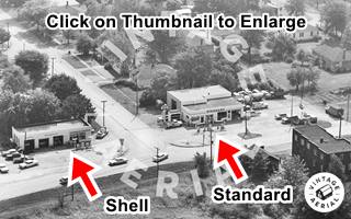
Ahead, on the main junction in town, were two gas stations, both gone. You can see them in the aerial photo thumbnail from 1967. The Shell was on the north side, known as Fassero and Sons it was an Art Deco brick building with box-columns and flat canopy. Later replaced in the 1950s by a box-shaped building with two service bays (pictured). On the south side of W Central Ave. was the Standard station, where the car wash is now located.
The image looks east, W Central Avenue is in the middle and IL 4 runs left to right on the bottom of the photograph.
Downtown Benld
It is likely that many travelers turned east along W Central Avenue to head into the town, for supplies, a bed or a drink. See its local landmarks, a two-mile trip (map with directions.)
But first some Trivia about Benld, like its meteor strike:
The Benld Meteor

Mr. McCain holding meteorite over his car. Source
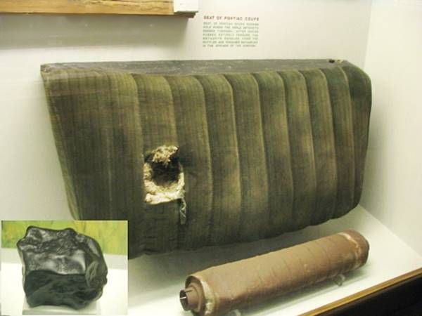
A meteor (chunk of space rock) hit Benld on September 29, 1938, striking the garage of Edward McCain, making a hole in its roof and striking his 1928 Pontiac Coupe.
The stone embedded itself in the upholstry of the back seat of the car. It weighed 3.9 lb (1.771 g).
A meteor that makes it to the ground without burning up in the atmosphere is known as a "meteorite". You can see both meteorite and parts of the car at the the Field Museum of Natural History in Chicago.
What are the odds of getting hit by a meteorite? There is roughly one in 20,000,000,000,000 chance of a square yard being hit by space rubble. That is equivalent to flipping a coin and coming up with heads every time, for 44 flips! The chance of a person being hit considering our 8 billion population on Earth is roughly 1 in 2,500.
The Benld Meteor and the car's seat
Head east and after crossing the railroad tracks, to your left is a red brick building on the NE corner of 2nd St. and E Central Ave., currently the location of the Civic Center used to be Fazio's Bar and Bowling Alley.
First National Bank of Benld
On the eastern corner of that block is the former bank, pictured below in a "Then and Now" sequence in 1913 and 2021, you can tell it is the same building by the
arches above the windows on the second floor (right side of both images).
Old Bank in Benld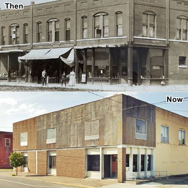
The building was erected in 1904, the wing behind the current vacant bank was the "Benld Hotel" and later was the venue of the "Newdan Club", a tavern. This wing was torn down. The bank is now across the street, where the Bertetti Bros. electric store once stood.
Head west, at 501 E Central Ave, to your left is an auto repair shop, (street view) formerly a garage with a Mobil gas station (1989 aerial photo). Turn around and head north along N 4th St. to visit an Orthodox church:
The Holy Dormition of the Theotokos Orthodox Church
On the NE corner at 304 N 4th St, Benld
The local parish was organized back in 1907 when there were many Eastern European imigrants working in the mines around Benld. But later the mines closed and workers moved away so attendance dropped.
The church rules state that an unused building must be torn down but the church officials saved it by converting it into a monastery.
The Holy Dormition is a Russian Orthodox Church of the Moscow Patriarchate and was built in 1915 when the original wood church burned down.
Back to Route 66
Retrace your steps back to Route 66, turn left (south) to visit the remains of a Route 66 Icon: the Coliseum Ballroom, just one-half mile south:
Coliseum Ballroom Site
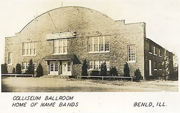
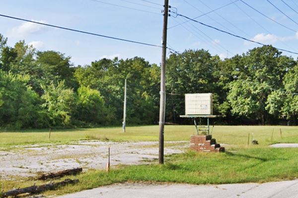
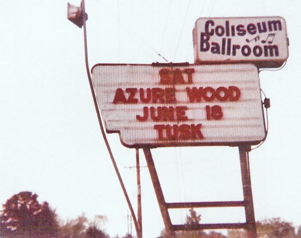
To your right, at 523 S Hardroad. The building is gone; an empty lot and a fading sign are all that remain. The Coliseum burned down in July 2011, in a blaze that required 150 firefighters to contain. During its last years it was the venue for antiques sales.
But it had an exciting history linked to bootleggers, racketeers and great bands:
The History of Benld's Coliseum
Dominic Tarro, the Coliseum owner 1924-30
Dominic Tarro was born in 1892, in Wakefield, Michigan. The son of Giovanni Tarro-Toma and Giovanna Contratto. With his youngest brother Benjamin John Trarro he ran a grocery store in Benld in the 1920s.
The story goes that the Tarros were involved in supplying Moonshiners with the ingredients they needed to produce their illicit liquor ("moonshine" or "bathtub gin") during Prohibition.
Prohibition was enforced by the 18th Amendment to the U.S. Constitution, which banned production, transporation and sale of liquors. It lasted from January 17, 1920 until December 5, 1933.
The ban on alcohol made illegal production and sale of liquor as well as its transportation ("bootlegging") a profitable business ran by criminals and the Mob.
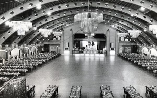
The Tarros' grocery provided funds for their ballroom. It was a 10,000 sq. foot area (929 m2) enclosed by a two story red-brick structure that supported a curved truss. It could seat 400 guests in the balconies around the main floor where another 400 could be seated.
It opened on Christmas Day 1924 and Tarros' connections provided booze and gambling for the patrons. County and state police knew about it and did nothing, Benld was the liquor capital of southern Illinois: its "Mine No. 5" was actually a disguised still.
Bootleg booze and murder
The Federal law enforcement agencys acted and in October 1920 Dominic Tarro was indicted for shipping "150 carloads of corn sugar" and "183,800 pound of yeast" to "the operators of stills in Macoupin and other counties" the forty defendants included "a group of Italians in Benld, Ill., and vicinity, and racketeers from St. Louis, Mo." (1)
But Dominic never got his day in court, he disappeared on his way to testify in Springfield (read a local newspaper's article: Alleged Liquor Ring Head Disappears in Illinois) on January 1, 1930. His remains were found in the Sangamon River in May 1930.
His widow, Mary Elaine Sexton (1898-1955) continued running the Coliseum with Benjamin (2). After the repeal of Prohibition, business boomed.
Golden Days and another murder
Dominic's daughter, Joyce Tarro ran the Coliseum from 1955 until her death, by murder in 1976. She came across some intruders when she came back to her home and opened fire with her handgun; they returned the fire, shooting her six times, and escaped after killing her. Two of the murderers were tried and convicted (3).
Joyce booked many stars: Fats Domino, Tina Turner, Chuck Berry, Tommy Dorsey, Duke Ellington, and Ray Charles were some of the celebrities that performed there. She almost had Elvis Presley perform here in the 50s, and she rejected the Beatles believing that the audience wouldn't pay the ten buck tickets for the performance.
A fire razed the Coliseum
After Joyce's death it served as an antique store and music venue. A fire caused by faulty electric wiring started while the band Shadow of Doubt was playing on July 30, 2011. The fire spread through the ceiling, roof and interior razing the building.
Below is a view of the site, vacant except for the neon sign:
Ahead, to your left, at Fisher St. ⁄ Sawyerville Hills Rd., is the small village of Sawerville:
Sawyerville
Pop 242 (2020)
Sawyerville is a small village in Macoupin County located on the south side of Benld just east of Route 66's 1926 alignment. It was named for Thomas Sawyer, a resident who sold part of his property to the Superior Coal Co. in 1904. The company founded the village in 1905.
The town's main attraction is its water resevoir.
Just 0.4 miles south of Sawyerville is an original segment of Route 66:
Old concrete road surface
1.4 miles south of Benld, to your left is Fritz Road in the small community of Sawyerville. This short segment only 0.3 miles long is the original roadbed. It still has the original 1920s concrete paving. It was also known as the "hardroad" now named Fritz Rd. See this Map with directions and the marker in our custom map.
Old concrete road surface in Sawyerville, Illinois
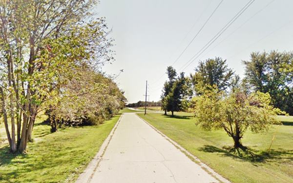
This alignment survived at least until 1956 because it appears in an aerial photo taken that year and the new soft-curve wasn't built at that time.
Notice the concrete "curbs" on both sides of the main concrete slab. Similar to the Modified Bates design used in the 1929 US 66 in Arcadia, OK.
Continue your Road Trip along Route 66:
This marks the end of your city tour of Benld, continue your Route 66 Road Trip by heading south (westbound) along Old Route 66 - IL-4 towards Staunton, the last town on this 1926-30 course of Rotue 66.

Sponsored Content
>> Book your Hotel in Chicago

Credits
Banner image: Hackberry General Store, Hackberry, Arizona by Perla Eichenblat
Coliseum Ballroom Documentary
Gillespie Coal Museum: Benld
St Louis Music Yesterdays: Coliseum


