Route 66's old an new alignments meet
Index to this page

TheRoute-66.com is reader-supported. When you buy through links on our site, we may earn an affiliate commission at no additional cost to you.
About Hamel, Illinois
Facts, Trivia and useful information
Elevation: 557 ft (170 m). Population Population 808 (2020).
Time zone: Central (CST): UTC minus 6 hours. Summer (DST) CDT (UTC-5).
Hamel is an incorporated village in Madison County in SW Illinois, located on the 1926-65 Route 66.
History of Hamel
For the early history of Madison County, read this.
What is now Hamel, was settled by Ferguson who built his log cabin on Chaokia Creek in 1811, he left in 1812. Only in 1817 did some families from Massachusetts settle the area.
More settlers arrived, as farmers, and used one of the "Edwardsville - Staunton Road", later followed by US 66. The school opened in 1825. German migrants arrived in the 1830s and by 1861 had erected a Lutheran church.
Frederick Wolf opened his general store at the crossroads of the Edwardsville - Staunton Rd. and the Alton-Greenville roads in 1865. Later Jack Hamel opened a store and a flower mill (1869).
The Name: Hamel
It was named Hamel's Corner after A. J. "Jack" Hamel, a farmer who owned property in the area.
English surname from the Old English word "hamel", meaning scarred, the French variant means village or homestead.
The Wabash Railroad built a station northeast of the village in 1877, it was named Carpenter. Route 66 was aligned through the village in 1926.
It incorporated in 1955, on the BYP US 66 of that time. In 1965 Route 66 would cease running through the town, moved to the alignment of present I-55.

Hotels and Motels: Hamel, Illinois
Accommodation and hotels in Hamel, sponsored content:
> > Book your accommodation in Hamel
More Lodging near Hamel along Route 66
Below you will find a list of some of the towns along Route 66 east and west of this town; click on any of the links to find your accommodation in these towns (shown from east to west):
Along Route 66 in IL
- Hotels in Illinois
- Route 66 Starting point ▸ Chicago
- Lockport
- Willowbrook
- Bolingbrook
- Plainfield
- Romeoville
- Joliet
- Wilmington
- Dwight
- Pontiac
- Chenoa
- Normal
- Bloomington
- Atlanta
- Lincoln
- Springfield
- Raymond
- Litchfield
- Staunton
- Williamson
- Hamel
- Edwardsville
- Collinsville
- Troy
- Glen Carbon
- Pontoon Beach
- Granite City
- East St. Louis
West in Missouri
- Hotels in Missouri
- Florissant MO
- Bridgeton MO
- St. Louis MO
- Kirkwood MO
>> Check out the RV campground nearby in Douglas
The weather in Hamel
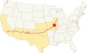
Location of Hamel on U.S. Hwy. 66, Illinois
Hamel's avrerage July temperatures (summer) are 90°F (32.2°C) -high, and 70°F (21.1°C) -low. The January (winter) temperatures average 36°F (2.2°C) and a chilly 19°F (-7.2°) respectively.
Rainfall his roughly constatn year round and peaks with 4.2 inches in April and May. The minimum is 2 inches (51 mm) in Jan.
You can expect snow, ice and sleet in winter.
Tornado risk
Hamel may be hit by some 7 tornados every year. Tornado Risk: read all about Tornado Risk on Route 66.
Map of Route 66 through Hameel, Illinois
This is the map with directions of Route 66 across Hamel, from 1926 to 1965.
Historic Route 66 in Hamel, Illinois
Route 66 passed through Hamel right from the start, since it was created in 1926. It was aligned along Illinois State Highway 4, from Staunton through Worden Junction, and then along what is now State Hwy. 157 into Edwardsville.
Later, as traffic increased a new alignment was necessary, in the early 1940s the highway moved to a straighter course through Livingston into Mt. Olive, bypassing Staunton.
A greater change took place in the early 1950s when a 4-lane highway was built and it bypassed Hamel.
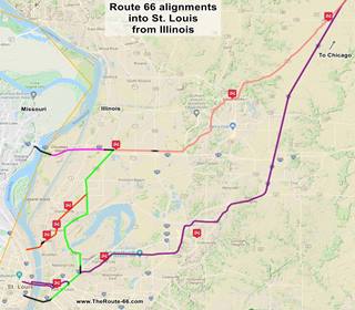
Click on the thumbnail Map to see a larger sized map showing Route 66 alignments that go into St. Louis MO west of Hamel. Hamel is on the upper right corner of the map.
Here two alignments of Route 66 split:
- Original 1926-54 Route 66 shown in "pink" in the map. It became BYP 66 after 1954 and ceased to exist around 1962.
- Main Route 66 from 1954-77. This alignment is shown in "violet" in the map.
In 1954, Route 66 forked into two alignments just north of Hamel close to its junction with Possum Hill Rd. that leads to the town of Worden, 2 miles west, and State Hwy. 4 (The 1926 to 1940 Route 66 alignment into Staunton).
This spot was known as Worden "Y" or Worden Wye for the "Y-shaped" fork here. We show it the map below in 1954, and this 1955 aerial photo showing the junction where you can see the work on the new four-lane roadway (now buried under I-55). The other map below shows the area south of Worden Wye, near Hamel, also published in 1954.
The 1954 map shows US 66 reaching the junction (upper right) and BYP 66 leaving it (lower left); the blue arrow shows Main 66. However, when the new fork between old and 4-lane '66 was built, it was located further south, at Green Hedge Rd. (the new "Main 66" hadn't been built in 1954 when the map was made). Later I-55 was aligned along this "new" roadbed.

1954 Map of US 66 near Worden, north of Hamel IL

1954 Map of US 66 alignments in Hamel IL
The map above shows the highways in Hamel: The original 1926-54 Route 66 ran through Hamel and in 1954 became the "Bypass 66", the new alignment on the right side of the map (further east) became the Main US66.
The Route 66 alignment in Hamel
Visit our pages with old maps and plenty of information about US 66's alignments.
- Route 66 Hamel IL to St. Louis MO (Next)
- Springfield to Hamel IL (1930-77 US66 east of Hamel)
- Springfield to Staunton IL (1926-30 US66 north of Hamel)
- Route 66 Pontiac to Springfield IL (Previous)
Route 66 Sights in Hamel
Landmarks and Places to See in Hamel
Historic Context
Jack Rittenhouse in his famous 1946 "Guidebook to Route 66" described Hamel as follows:
HAMEL (Pop. 160), a small farming community with several implement stores. Hamel Service Co. Garage. No cabins or other except gas Rittenhouse (1946)
We will tour Hamel starting from the east, driving along the 1926-40s Route 66 that came from Staunton south along what originally was the first "hard" road from Chicago to St. Louis, Illinois State Highway 4.
This road turned towards the southwest at its intersection with Possum Hill Road at Worden Wye (after the Y-shaped junction9. The town of Worden is two miles west of the junction. Later the 1950s Route 66 via Livingston would also reach it. Below we describe this busy intersection.
Worden
Named in 1870 after John C. Worden, who owned the land the town was platted on. It's first name was New Hampton (1860). Pop. 875 (2020)
Worden Wye: Crossroads of three US-66 alignments
Rittenhouse described it in his guidebook as being 4 miles west of Livingston:
(23 mi.) Junction with a road (R) to STAUNTON. A truckers's stop is at the junction, with gas and cafes and a few cabins. At... (22 mi.) is Nelson's Tourist Court, with a gas station. Rittenhouse (1946)
The picture below taken in 1933 looks north along Route 66, with Possum Hill road forking off to the left into Worden (left-middle), and behind (upper part of image -red arrow) it continues nortwards towards Staunton and Mt. Olive:
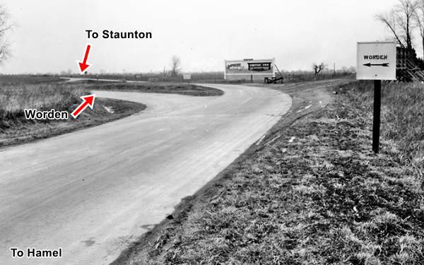
The inset map shows this same junction in 1932 (same layout as shown in the photo above), and 1991 after the interchange with I-55 was completed. Both maps have the same scale:

1932 Map of US 66 at Worden Wye

1991 Map of US 66 at Worden Wye
Schlecte's Service Station and Worden Y tavern
Inducted Route 66 Association of Illinois Hall of Fame Members (2002)
There were several buildings here but only one remains the former Worden Y nightclub at the site of Schlecte's Service Station. Fred Schlecte a coal miner amd farmer had the first gas station built in 1937. It catered to the over 3,100 vehicles that drove by every day here at Worden Wye (1).
Fred's son Harry owned the "Worden Y" nightclub next to the filling station.
Construction of the four-lane highway disturbed the "Y" junction and in 1954 Fred moved further north along the old 1926-40 US 66, when I-55 was built, the interchange was modified, and the new access ramps reached his property.
This aerial photo from 1968 shows the ANCO gas station (left) and the roadhouse (right). Later a canopy was added. The station is closed and vacant but the Worden Y Club Restaurant is open as Slotzy's (formerly it was the "Digger's Digout.") Below is a current view of the spot, the old station was torn down recently:
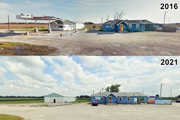
Frank & Harold's Cafe and Service Station was also here, but the two story gable roof buildiing was torn down.
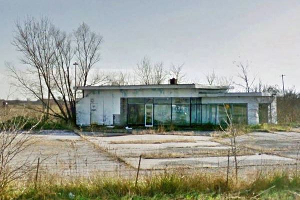
Gas Station (gone)
On the SE corner of Possum Rd. with W. Frontage Rd and State. Hwy 4. Exit 33 of I-55 facing Schlecte's. This station was built after 1968, and was torn down around 2018.
Worden Wye Motor Court (gone)
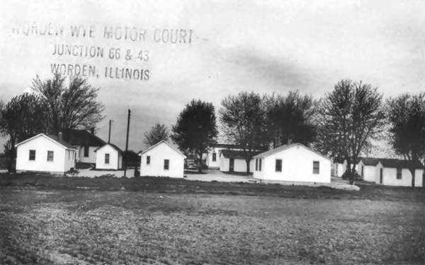
The postcard below belongs to the "Worden Wye Motor Court Junction 66 & 43 Worden, Illinois". This is on the southern side of the junction. IL-4 curved to the SW after meeting Possum Hill Rd. but its extension southwards was state highway 43. Nowadays renumbered as IL-4 and heads south another 99 miles, all the way to Murphysboro.
These must be the "few cabins" mentioned by Rittenhouse.
Nearon's Tourist Cabins - Nelson's Cabins
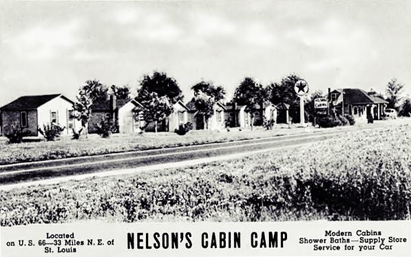
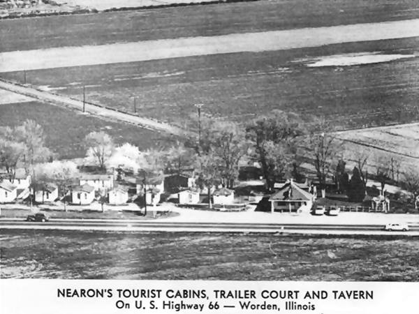
Follow the West Frontage Rd. towards Hamel. As mentioned by Rittenhouse, Nelson's was one mile SW of the Wye, along Route 66 and it can be seen in this 1956 aerial photo, now a small copse of trees on the left side of the highway mark the spot (see map). The eastern side of the cabins was cut by the four-lane '66 in the 1950s but it was I-55 that finished it. The road on its southern side (Brandt Rd) was also cut off from the traffic along the four-lane highway.
The complex was known as "Nearon's Tourist Cabins, Trailer Court and Tavern" and it had a Texaco gas station. The same set of buildings including the hip roofed service station appears in another postcard as "Nelson's Cabins". Both are pictured below.
The image below looks east, Livingston and Worden Wye are to the left, Hamel to the right, and I-55 would run across the image from left to right behind the cabins. You can see Brand Rd. cut across in an angle from the upper left to the lower right of the image (same view nowadays).
Church of the Neon Cross
Ahead, after 0.7 mi, at 6969 W. Frontage Rd. Worden, to your right is the majestic church.

The Neon Cross at St. Paul Lutheran Church.
This building was dedicated in 1931 as Saint Paul Lutheran Church. It cost $46,000, quite a sum in those days. The congregation was established here in 1856 in what was known as New Gehlenbeck.
It gets its name from the neon cross which was placed there in memory of a member of the congregation who died in World War II. See its Street View.
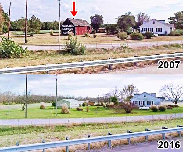
Across the freeway (accessible by the overpass just north of the Church), on the eastern frontage road is the Site of the Meramec Barn sign:
Site of the Meramec Barn sign (gone)
To your left, E Frontage Road, south of Church Road overpass, Hamel
The exact spot is shown in This map.
The Meramec Caverns near Stanton on Route 66, also known as "Missouri's Buried Treasure" is the largest cave West of the Mississippi. It was discovered in 1720 by French explorer Philipp Renault. It became a dance venue in the 1890s but it was not until Lester Dill (1898 - 1980) bought it in 1933 that it became a tourist attraction. Dill already ran Fisher's Cave in "Meramec State Park", so Dill renamed it as the "Meramec Caverns".
Dill promoted his tourist attraction in very cunning ways: He paid farmers so that they painted the words "Meramec Caverns" on barn roofs all across the region, 14 states in all (See some surviving barns on Route 66 here: in Conway MO, St. Clair MO, Cayuga IL, Phillipsburg MO, and Chandler OK).
One of those barns stood here in Hamel until it was badly damaged by a Tornado in late February 2011. The sign had been restored a few years back and dated to the 1950s, the barn was much older.
This is the "Then and Now" photo sequence, click image for current street view
Meramec Barn advertisment site in Hamel, Illinois
Hamel, the town's sights
Head back and drive into Hamel. At its main crossroads (US 66 and State Hwy 140 or State Rd.) you will find several classic Route 66 landmarks:
Cassens Dealership and Cassens Transport
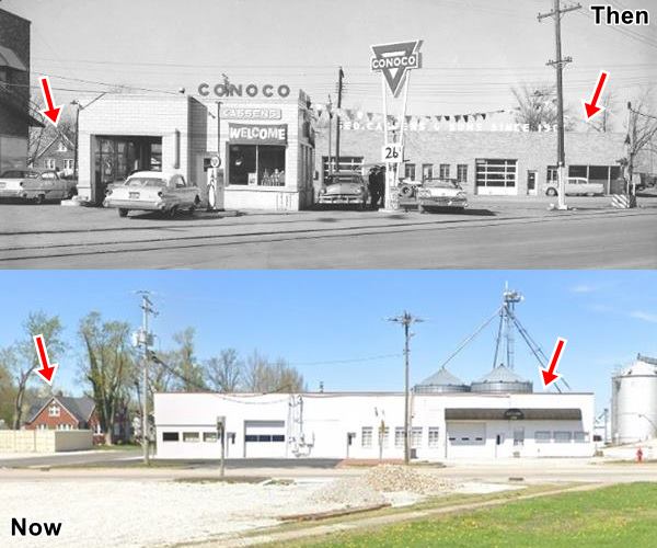
To your right, on the NW corner of the intersection. George Cassens owned a local dealership and his sons Arnold and Albert built a transport company starting in 1931. They began by brining cars to George's dealership. This building survived.
The building is still there, a brick faced, low, single-floor property facing State Rd. The letters along the parapet "Geo. Cassens & Sons since 1901" have gone but the building is intact (red arrows on the right in the "Then and Now" sequence below).
Facing it, on the SW side of State was the Cassens Conoco station, that was torn down and a brick building next to it, was a two story brick building that was Cassens Garage, also gone. The gable roof house to the left (red arrows) is still standing.
The tracks of the Illinois Traction run across the image, more on this below.
The image below looks north from Route 66 towards State St.
Illinois Traction - ITC
The Illinois Traction, that later became the Illinois Terminal Railroad was a heavy duty interurban electric railroad with passenger and freight service. The railway built a small station in Hamel on its Springfield-Granite City line (which ran between 1904 and 1956). The company had over 550 miles (900 km) of tracks in central and southwestern Illinois.
It was associated with streetcars in the large cities and ran along the streets of the towns along the network. It had a cross-country passenger service. Popularity of cars in the 1940s and 50s led to its demise.
The tracks in Hamel ran parallel to Route 66 on the south side of town, running just south of the highway, and crossed to its north side as it approached State Rd. then it ran parallel to US66 north of Hamel before veering off to go through Worden and Staunton.
Fowley's Tavern
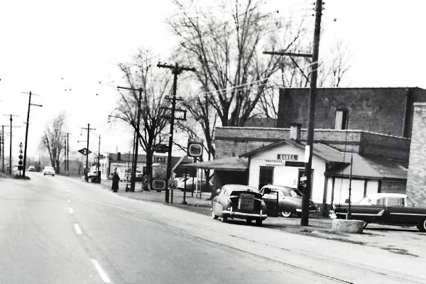
This building has survived, it stood on the south side of Cassens garage, and was "Fowley's Taven" in the 1950s. It is a brick structure with two windows facing Route 66 and a second floor on its western side. Now it is a tanning salon. You can see it in the two images below, one from the 1950s (notice the ITC tracks to the left), and the other taken in the 2020s.
The image below (c.1950) looks south along Route 66 from State St. It shows the western side of the highway.
Same view nowadays.
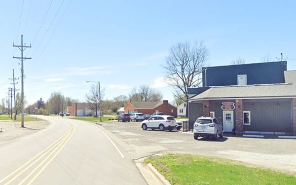
The red brick building in the distance is a former D-X gas station.
Facing Fowley's is another local landmark.
Hamel Haven now Weezy's Route 66
Route 66 Hall of Fame historical site
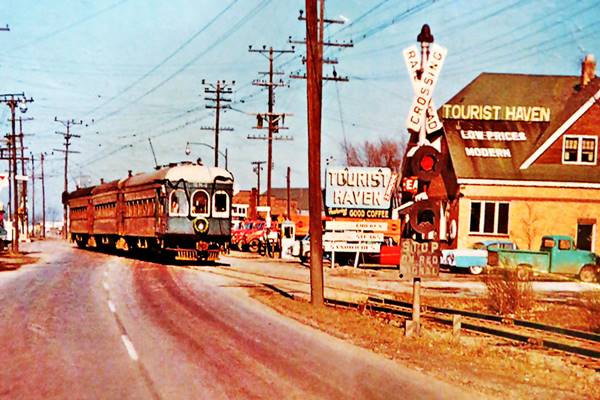
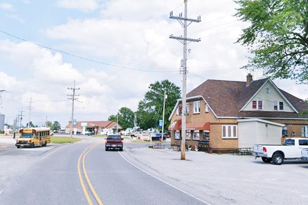
At 108 S Old US Route 66. George Cassens opened the former Tourist Haven Restaurant in 1937, its kitchen was ran by his wife Louise. The Cassens truck drivers and those driving along Route 66 dined here.
Noe its name is Wheezy's but it has had many names over the years: Tourist Haven -see photo below, Earnie's Roadhouse, Village Inn are some of them.
It has not changed much over the years and its interior walls have interesting photographs of the bygone days. You can still get a good meal here!
The vintage photograph shows a train of the Illinois Traction (or Illinois Terminal Railroad):
A 1950s view of "Tourist Haven" and the ITC streetcar and tracks
Weezys nowadays, old ITC streetcar and tracks long gone!
Wayside Marker at Hamel
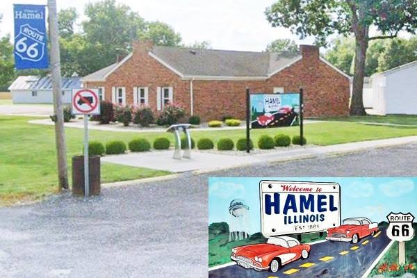
Across the street, to your right you will see one of Illinois US66 wayside interpretive stations. It gives a quick overview of the history and landmarks in Hamel. You can also stamp your Route 66 passport here (bring ink). It has a nice "Welcome to Hamel" billboard with a Route 66 painting for a great photo.
Just ahead, to your right is a box-shaped former D-X gas station with a red-brick facade and concrete block side walls.
Hamel School Log Cabin
Hamel School Park, 400 W. State Rt. 140 on the eastern side of the school. (street view)
Drive west along State St. (IL-140). Now it is a museum. This log cabin was built between 1820 and 1852. It preserves artifacts from that period. Visit by appointment only.
This part of your journey ends here; continue your Route 66 Road Trip westwards along the Main 1954-77 alignment towards Collinsville or stay on the 1926-60 alignment and visit Edwardsville.

Sponsored Content
>> Book your Hotel in Chicago

Credits
Banner image: Hackberry General Store, Hackberry, Arizona by Perla Eichenblat
Jack DeVere Rittenhouse, (1946). A Guide Book to Highway 66.
Great vintage pictures of Hamel


