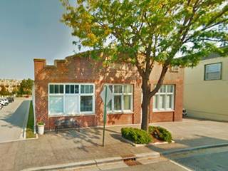
Route 66 in Lemont IL
Index to this page
About Lemont IL
Facts, Information and trivia
Elevation: Elevation 607 feet (185 m). Population 17,531 (2022).
Time zone: Central (CST): UTC minus 6 hours. Summer (DST) CDT (UTC-5).
The Village of Lemont is located in DuPage and Will Counties in NE Illinois, on the southern side of the Des Plaines River.
History of Lemont
Settled by Paleo Indians at the end of the last Ice Age around 11,000 years ago, these evolved into the historic Potawatomi people encountered by the French trappers and explorers in the 1600s.
After the Seven Year War (1756-1763), France lost its Canadian colonies to England. Then, after the American Independence, what is now Illinois became a part of the U.S. In 1803 the American government established Fort Dearborn where Chicago is located.
The territory was organized as the state of Illinois and admitted into the Union in 1818. The first white settlers sarted arriving in the late 1820s. Some moved along the Des Plaines River to the west of Ft. Dearborn and settled in what is now Lemont.
Des Plaines River
The Des Plaines River was a trade route used by the Native Americans linking the Great Lakes with the Illinois River and the Mississippi basin.
The river is 133 miles (214 km) long and its discharge flow is 535 cubic feet per second (15 m3⁄s).
The French named it as La Rivière des Plaines (River of the Plane Tree) after the trees along it.
The Des Plaines linked with the Chicago River across the Chicago Portage, a link that had strategic importance and led to the creation of Ft Dearborn.
When the first settlers arrived in Lemont, the area was known as Keepataw, after a local Potawatomi chief, and the first post office here in 1840 adopted that name. Over the years it changed to Athens and then Palmyra in 1850. Shortly after it was changed to Lemont at the suggestion of the local postmaster Lemuel Brown.
The name: Lemont
From the French word for "the mountain" (le mont), probably chosen by Lemuel Brown as he, and his brother Nathaniel, came from Lamont in New York state. There are no mountains in this area.
Black Hawk War
The Sauk and Meskwaki (or Fox) tribes lived along the Mississippi River in what are now the states of Iowa and Illinois. In the late 1820s and early 1830s the American government ceded their land to settlers and informed the natives that they should move west of the Mississippi. This triggered a war led by Sauk warrior Black Hawk. The war was short (April to August 1832) and ended with the defeat of the natives and led to the Indian Removal policy by which all Native Americans east of the Mississippi were forcibly removed to the wester side of it.
Illinois & Michigan Canal
A group of businessmen organized to build a canal to link the Great Lakes with the Mississippi River to move their farm's produce and trade with the eastern states. It would also allow goods to move west, linking the Great Lakes with the Gulf of Mexico via the Illinois and Mississippi rivers.
In 1825 the State Legislature incorporated the Illinois and Michigan Canal association, but the construction of the canal was delayed many years. Work started in 1836 and concluded in 1848.
Many of the immigrant workers hired to dig the canal stayed on and settled in Lemont. They also discovered a hard and fine grained dolomite called "Athens marble", used in construction in the region, specially in Chicago . Quarries became an important part of the local economy. The town incorporated in 1873.
The railroad gradually replaced the traffic along the canal, and by the early 1900s it was falling into disrepair. At that time the deeper and wider Chicago Sanitary and Ship Canal was built parallel to the old canal, and it moved the sewage of Chicagoland west, away from its fresh water supply in Lake Michigan.
The I&M canal formally closed in 1933.
The Pontiac Trail was established through Lemont in the early 1900s, followed by State Highway 4 in the early 1920s, and Route 66 went through the town in its first alignment from 1926 to 1928. Learn more about US 66 through Lemont below.

Accommodation in Lemont
> > Book your hotel in Chicago
Find More Accommodation near Lemont along Route 66
Below you will find a list of some of the towns along Route 66 east and west of this town; click on any of the links to find your accommodation in these towns (shown from east to west):
Along Route 66 in IL
- Hotels in Illinois
- Route 66 Starting point ▸ Chicago
- Lockport
- Willowbrook
- Bolingbrook
- Plainfield
- Romeoville
- Joliet
- Wilmington
- Dwight
- Pontiac
- Chenoa
- Normal
- Bloomington
- Atlanta
- Lincoln
- Springfield
- Raymond
- Litchfield
- Staunton
- Williamson
- Hamel
- Edwardsville
- Collinsville
- Troy
- Glen Carbon
- Pontoon Beach
- Granite City
- East St. Louis
West in Missouri
- Hotels in Missouri
- Florissant MO
- Bridgeton MO
- St. Louis MO
- Kirkwood MO
>> See the RV campgrounds in Chicago or in Joliet and Braidwood
The Weather in Lemont
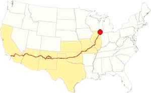
Map showing the location of Lemont, Illinois on U.S. 66
The climate in Lemont has clearly defined seasons and his humid and continental. Spring is cool and wet; summer is hot and frequently humid. Winter is cold and has on average 28 inches (71 cm) of snow, while Fall is very mild.
Temperatures: Average high in Jan (winter) 31°F (-0.3°C) and the average low is 17°F (-8.6°C). Average high in Jul (summer) 84°F (29°C), with an average low of 64°F (17.7°C).
Rain averages 36.82 inch (936 mm) per year and it is highest with 3 to 4.3 inch monthly (78 and 110 mm) begins in Apr. The rest of the year has an average of 1.7 in. (28 mm) per month.
Snow: In Lemont you can expect snow from October to April, however usually the first snow falls in Nov. and the last happens in April (usually one quarter inch -8 mm).
Tornado Risk
The region around Lemont experiences about 4 tornados per year.
The June 13, 1976 tornado killed 3, injured 23 and detroyed 87 homes. The March 27, 1991 Tornado struck the town but caused no casualties.
Tornado Risk: read more about Tornado Risk on US 66.
The Maps of Route 66 in Lemont
>> Our Custom map shows the different US 66 alignments in Lemont.
 >
>
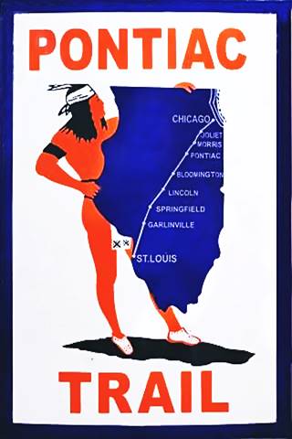
The Pontiac Trail symbol shield
Lemont and Route 66
The first decent highway through Lemont was the Pontiac Trail that predated U.S. 66 by eleven years.
History: The Pontiac Trail and State Highway 4
The need for decent roads led to the formation of private associations that lobbied for better highways and designated, and marked them. In 1915 the Pontiac Trail became the main road linking Chicago with St. Louis. It had been named after the famous Ottawa Indians chief and B.F. Goodrich marked the milage posts, it even had its own shield sign (see image).
A newspaper article about it, published in 1915 describes its Lemont segment as follows: "Passing Summit, the traveler on the highway can, by a short detour, pss the monument of boulders marking the spor where Farther Marquette camped, and where he first saw the Desplaines river on his voyage of exploration to the Mississippi. From Summit the road leads by ARgo, with its mammoth corn products plant, by the stone quarries of Lemont and Lockport to the bustling industrial city of Joliet." 1
But the public demanded that the state take care of its highways, so a bond was issued in 1918 to build hard sufvaced roads in the state of Illinois, and the Pontiac Trail was to become the SBI 4 (State Bond Issue) highway number 4.
Federal funds were also provided and the road was paved along its whole length by 1923. It had a winding course, following the railroad and county lanes but it provided a good road between both cities. It passed through Lemont, Lockport, Joliet and further south, the state capital in Springfield.
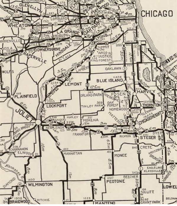
The map below published in 1924, two years before Route 66 was created, shows the different Auto Trails in the area close to Chicago. These Auto Trails were roads that were good enough to be driven by cars. Those marked with numbers in black boxes are named trails, for instance "34" was the "Lincoln Highway" and you can see it running into Joliet and through Plainfield. The numbers inside white circles were the state highways: the "4" inside a white circle is State Highway 4. It runs through Lemont and Lockport to Joliet to the south and east of the Des Plaines River, it would be the first alignment of Route 66 in 1926. And we marked it with a bordeaux line in our custom map
Route 66 and its first alignment
Route 66 was created in 1926 and it used pre-existing highways as its first alignment; in this area it used State Hwy. 4. And from 1926 to 1928 it went from Lyons to Joliet through Lemont, and Lockport, along the southern and eastern side of the Des Plaines River and the Illinois & Michigan Canal.

1928 Illinois State roadmap (see State Hwy 4A). Source
Click map to enlarge
Route 4A and the new Route 66 alignment (1928?)
But soon the new roadway that ran along the north and western side of the Des Plaines river through Romeoville, with a straighter course across open countryside with farms and fields (the current town of Countryside on this alignment got its name for this reason). The new alignment avoided the urban crossings of Summit, Justice, Argo, Lemont and Lockport; it also eliminated many sharp curves and turns.
The new alignment was re-designated as both US 66 and Route 4. The old alignment was designated as Route 4A. You can see it in the map (click to enlarge). Near Romeoville, it ran along what is now IL-53 from I-55's exit 267 and Joliet Rd (green line in our custom map). But shortly after it was shortened by aligning it along Joliet Rd. to Welco Corners.

1927 Chicagoland map. Source
Click map to enlarge
The 1927 map of Chicagoland shows both Route 4 and 4A the thumbnail image (click to enlarge) shows them from Lyons to Joliet. Notice the many curves and turns along 4A vs. Route 4. Both start in Cicero and meet in Joliet after splitting in Lyons.
Maps of the different alignments
The color keys to the alignments in Romeoville, and a brief description of each one is given below.
The bordeaux line in our custom map is the one described further up, along the south and eastern sides of the Des Plaines River along the original IL-4 highway. Used from 1926 to 1928.
In 1928 it was realigned along the north and western side of the river (violet line from Lyons to Welco Corners, and pale blue through Romeoville to Joliet). It carried U.S. 66 from 1928 to 1940.
Realignment of Route 66 through Plainfield, this took place in 1940 (red line from Welco Corners to Plainfield and yellow line south of it). The older alignment became ALT 66.
The ALT 66 alignment remained in use until February 1967 when it was replaced by Illinois State Highway 53 from Welco Corners to Gardner.
In 1958 US 66 was moved east west to a brand new freeway that now bypassed all the towns including Plainfield, Braidwood and Gardner. US 66 and I-55 shared the freeway until 1977; see the violet lines in our custom map from Gardner and east of Plainfield.
The old Route 66 is a Historic highway and has also been designated as a National Scenic Byway and an All-American Road in the state of Illinois.
The Route 66 alignments near Lemont
Description and interactive maps of US 66.
- Pontiac to Springfield (next)
- Chicago to Pontiac (Lemont's)

Lemont's Route 66 Landmarks and Attractions
Your Route 66 Road Trip sights
US 66 in Lemont, the historic context
Jack DeVere Rittenhouse does not mention Lemont in the "Guide Book to Highway 66" he published in 1946 because he begins his detailed description in Plainfield.
The WPA's guide to the state of Illinois published in 1939 in its Tour 22 describes the area as follows, heading west from Chicago:
...the Des Plaines River enters the valley, and parallels the waterway for 23 miles to Lockport. Left is the old Illinois and Michigan Canal. On either side of the mile-wide valley the wooded bluffs rise sharply to the rolling upland. Between approximately 18 m. and 23 m. the Argonne Forest Preserve (L) borders the valley — an extensive Cook County recreational area largely in its original wildland state... LEMONT... (605 alt., 2,582 pop.), an old towpathtown, raises its hill-crowned head among the trees." WPA (1939)
Driving westwards from Lyons, there are no remains of any Route 66 landmarks in Summit, Argo, Justice or Lambert. However the wilderness area is still there. The Pontiac Trail, later IL-4 and US-66 entered Lemont along its Main Street and reached the Lemont Downtown Historic District.
You can reach Lemont from the later (1928-77) alignment from Willowbrook it is only 4.2 miles to Lemont (map with directions).
Lemont Downtown Historic District
Listed in the National Register of Historic Places
The Historic District spans 14 blocks (16 acres) of Lemont along Main, Canal and Stephen Streets with many intact buildings from the mid 1800s to the early 1900s. The oldest dates back to 1858 at 328 Main St. though it was transformed in the 1970s and again in 2020. Some of the buildings on the 200 Main St. block were torn down when the State Street Bridge was built in the 1980s, among them was the Curve In Station.
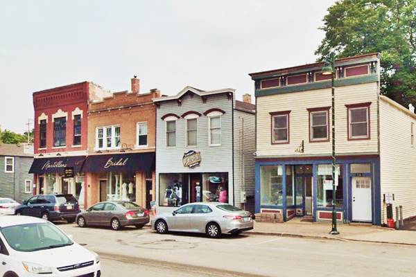
Garages
Those driving the Pontiac Trail or the first Route 66 surely would have visited the garages in the historic district. The town's first car dealerships and gas stations were opened on lands formerly occupied by canal-related businesses or on the fringes of the main commercial district that expanded outwards. Among these buildings was Holster's garage at 305 Canal St. that was built in 1920 (pictured) or the other garage around the corner (razed) at 170 Lemont St. and the Willys-Knight Dealership Garage and Showroom at 44 Stephen St. built in 1925, still standing.
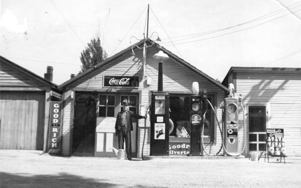
John Roebuck's Gas Station
One block south, at 223 Illinois Street was John Reobuck's Texaco service station. One block from Main and State streets, the main throughfares in town, it is pictured below with John Roebuck by his pumps.
Curve In Station (or Curve Inn?)
In the book Route 66 in Illinois, Sonderman and Eichar Jett include an advertisement showing a map with the "Curve In Station" in Lemont. The text states that it was located on Highway 66 at Main Street in Lemont but calls it the "Curve Inn". 2 Was it a gas station or an Inn?
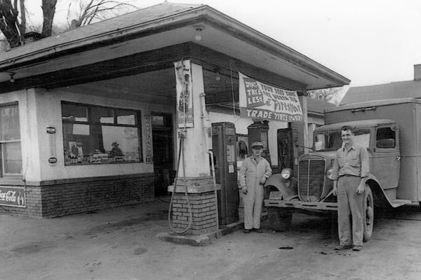
In fact, at the intersection where State Street met Main Street, and the highway turned 90° (quite a curve!) there was a gas station and an Inn, on opposite corners.
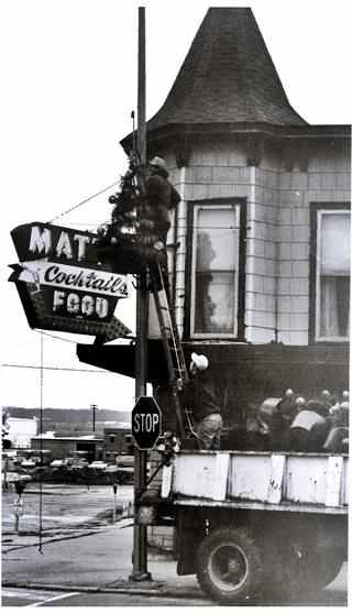
Matt's Inn State & Main St. c.1974. Lemont IL. Source
On the SW corner was Shorty's Service Station pictured above. It was located at the bottom of the hill where State intersected Main St. and New Ave. This was in the days before the current overpass bridge was built in the 1980s. The 1894 Sanborn Map of the site shows the Marble City Hotel on that corner. But the aerial photograph from 1938 shows the gas station there.
Kitty-corner from Shorty's (NE corner) was the stately two story building with a corner turret known as Matt's Inn Tavern. Its neon sign read "Matt's Cocktails Food."
The image looks towards the NW from Main, State St. to the left and the railroad beyond. It was torn down to make space for the viaduct.
Oak Grove Station Site
Drive westwards along State Street and at 127th St., to your left, on the NE corner was Fred Meyer's Sinclair gas station. Now a Walgreens stands on the property. The image below is from around 1922. This 1938 aerial photo shows it on the upper right side of the crossroads.
oak-grove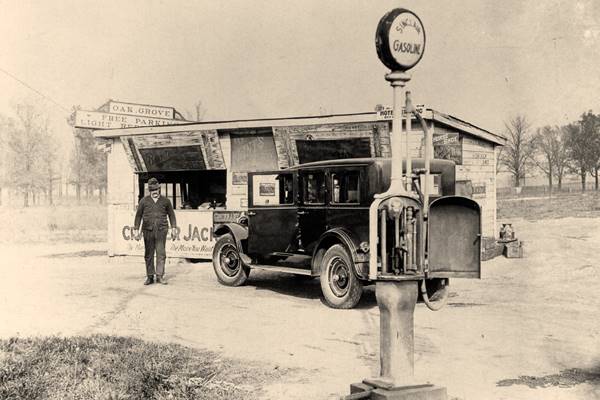
Continue your Road Trip
This spot marks the end of this leg of your road trip through Lemont. To continue your journey you have several options: return to Willowbrook and head west to visit Romeoville on the 1928-40 US 66 ⁄ 1940-67 ALT 66, the main sight there is the White Fence Farm (4 miles; map with directions).
Or continue straight along the original alignment of Route 66 into Lockport (7 miles; map with directions).
Both Romeoville and Lockport lead you to Joliet and Wilmington.
The final option goes along the 1940-77 Route 66 west of Welco Corners into Plainfield (16.4 mi; map with directions).

Sponsored Content
>> Book your Hotel in Chicago

Credits
Banner image: Hackberry General Store, Hackberry, Arizona by Perla Eichenblat
Jack DeVere Rittenhouse, (1946). A Guide Book to Highway 66.


