Route 66's First alignment in Albuquerque NM
Albuquerque's Attractions along US 66
A List of Stops and Landmarks
We will use the ❌ symbol to mark those that have been torn down.
1. Eastern Albuquerque
- Paradise Club ❌
- Little Beaver Town ❌
- Original 1930s Roadbed
- Holiday Inn East
- Bar-B-Q Inn
- Phillips 66 Gull Wing service station
- Tropicana Lodge, later Nendel's ❌
- Caravan Nightclub neon sign
- Iceberg Cafe in East ABQ ❌
- Rodeo Court ❌
- Steer on a pole
- Eldorado Court later Roma Motel ❌
- Zuni Motor Lodge ❌
- Muffler Man
- Fair Grounds Motel ❌
- Carrico Modern Court ❌
- Sundowner Motel & Bill Gates
- Former Denny's Diner
- Leonard's ❌
- Tracy's Modern Court ❌
- Trade Winds ❌ / Replica Neon Sign
- Honey Dew Drive Inn ❌
- Nod-A-While Motor Lodge / Silver Spur ❌
- American Car Wash
- Cooksey Court, later New Mexico Motel ❌
- Bimbo's Drive In ❌
- Anchor Inn / Bar-X Motel& ❌
- New Chinatown Restaurant neon sign
- Ambassador Lodge ❌
- Coronado Court ❌
- El Sombrero ❌
- American Motor Inn
- La Puerta Motor Lodge
- Luna Lodge
- Piñon Motel
- Lo-La-Mi Lodge ❌
- Bow & Arrow Lodge
- Chevron Gas Station
- Phillips 66 Gull Wing Gas Station
- Loma Verde Motel
- Pioneer Motel
- Texaco Station
- Ace Cafe
- Tewa Lodge
- La Vela Lodge
- Desert Sands Motel Neon Sign
- Hiland Theater
- Zia Motor Lodge
2. Nob Hill
- De Anza Motor Lodge
- Circle K Motor Court
- Bel Air Motel
- Goody's Restaurant
- Martens Tourist Court and Trailer Park ❌
- Comfort Lodge
- Town House Restaurant
- Aztec Court ❌
- Two Gas stations, one gone, Mobil survived
- One of the First KFC in ABQ
- Kurt's Camera Corral ❌
- Original Iceberg cafe ❌
- Rainbow Cafe
- Hiway House Motel
- Pipp's Texaco
- Triangle Cafe ❌
- Tonnie Pegue's Standard Oil Service Station ❌
- Lobo Joe's ❌
- El Oriente Auto Court
- Premiere Motel
- TraveLodge Motel
- The Toddle House
- Nob Hill Motel
- Nob Hill Conoco
- Johnson Standard Station
- Nob Hill Business Center
- Jones Motor Company & Texaco
- Valentine Diner Police Substation
3. Downtown
- Pig and Calf
- 66 Diner
- A Phillips Petroleum Gull Wing
- Cottage Bakery
- Zia Oil Station
- Park Lane Hotel ❌
- Lorlodge Motel
- Central Ave. Underpass
- Hiway House #1 ❌
- Railway Depot
- Glorieta Sation Neon Park
- Yrissari Building: Maisel's first store
- Franciscan Hotel ❌
- Sears
- Hospital
- Little House Cafe ❌
- Crossroads Motel
- Hyatt Chalet Motel
- Whole Hog Cafe
- Imperial 400 Motel
- TraveLodge Downtown
- Hilton Hotel
- El Fidel Hotel
- Kimo Theater
- Lindy's Coffee Shop
- Maisel's Indian Trading Post
- Holocaust & Intolerance Museum of New Mexico
- El Rey Theater
- Firestone Tires
- Downtowner Motor Inn
- Skinner Grocery
4. Old Town & Western Albuquerque
- Chevron ❌
- Lorlodge West
- Bell Indian Trading Post
- World Court ❌
- Desert Inn ❌
- Arrowhead Lodge ❌
- Texas Ann Court ❌
- Moon Motel and Café ❌
- White Way Court ❌
- Katson's Drive Inn ❌
- Country Club Court ❌
- Pueblo Bonito Court ❌
- Casa Grande Complex ❌
- Tingley Beach and Beach Motel ❌
- Rio Grande Bridge
- The Volcanoes
- El Nido Motel ❌
- Rainbow Court
- Sandia Motel ❌
- Duke's Court ❌
- Stop In Court ❌
- Auto-Tel Court ❌
- Miller's Court ❌
- Silver King's Auto Court ❌
- Blue Bell Court ❌
- Hill Top Court ❌
- Arrow Court and Hill Cafe ❌
- Navajo Court
- Dutch Motel ❌
- California Court ❌
- Hill Crest Motel ❌
- Sky Court ❌
- Mile Hi complex
- Covered Wagon Court
- Hubbell Motel ❌
- Oasis Lodge ❌
- Phillips 66 Gull Wing ❌
- Jerry Unser ❌
- Route 66 Conoco
- Route 66 Travel Center
- Capri Motor Hotel
- Horn Oil Co. Motor Lodge
- Sandia Theatre
- Old Town of Albuquerque
- San Felipe de Neri Church
- Tower Court
- El Don Motel
- Monterey Motel
- Country Club Court
- El Vado Auto Court Motel
- Relict Motel Signs: Cibola and Super 6
- El Campo Tourist Court
- La Hacienda Camp
- Siesta Court
- Americana
- Western View Diner and Steak
- Adobe Manor
- Westward Ho Motel
- French Quarter Motel
- Grandview Motel
5. Fourth St. Route 66 (This Page)
- Cavalier Court ❌
- Crossroads of Route 66
- Ruffin's Texaco #1
- Horn Oil North 4th St.
- Ruffin's Texaco #2 ❌
- El Camino Motor Hotel
- King's Rest Court ❌
- Court John ❌
- Madonna of the Trail
- Monkbridge Manor ❌
- Luke Apartments
- Clyde Miller Tire & Service Station
- Texaco Gas Station
- Scott's New Motel ❌
- Barelas-South Fourth Street Historic District
- Hudson Auto Sales
- B. Rupee Drugs
- Tasty Freeze Drive In
- Durand Motor Company
- Hi-Way Service Station - Horn Oil
- Sinclair Service Station
- Magnolia Service Station
- Navajo Super Service Station
- Red Ball Cafe
- Fito's Cafe

The original Route 66 in Albuquerque: Sights and Stops
Along the 1926-37 Route 66 into ABQ
In this page we describe the classic Route 66 sights from north to south along the first alignment of U.S. Hwy 66 into Albuquerque. It was designated in 1926 along Fourth Street, and remained aligned along it until 1937 when the Santa Rosa Gap was closed and the Santa Fe Loop bypassed with a newer and straighter highway.
We will use the ❌ symbol to mark those that have been torn down.
The first Route 66 in Albuqurque
Your Route 66 Road Trip through Albuquerque Part 5
We will start this segment, driving south from Bernalillo along the 1926 to 1937 alignment known as the The Santa Fe Loop. After U.S. 66 was realigned, U.S. Hwy. 85 was moved to 4th Street and Camino Real from Albuquerque to Santa Fe, so there are some motels and buildings that are newer and didn't belong to the first Route 66, however they are interesting from a historic point of view so we will list them in this itinerary.
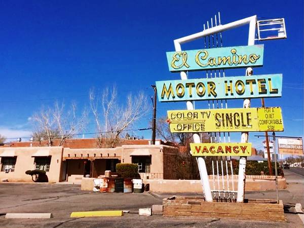
El Camino Motor Hotel
At 6851 4th St NW, Los Ranchos de Albuquerque, NM. To your right. The 30 unit El Camino Motor Hotel opened around 1952. The name comes from the "Camino Real" or "Royal Highway" that was built by the Spanish in the 1700s to link Santa Fe and Albuquerque with their main enclave in Mexico. Its postcard boasted it was "One of the Southwest's Finest Motor Hotels", it was owned by Goldie and Clyde Tyler and managed by Ivan and Alta Shoemaker. It is still there, to your right, and opposite is the Restaurant. Its neon sign changed in the late 1950s to the current one as you can see in the images below.

1952 postcard El Camino Lodge. Source. Click to enlarge

1950s postcard El Camino Motor Hotel. Source. Click to enlarge
The two images above show how the sign changed and also the name, from "Lodge" to "Motor Hotel."
Texaco Gas Station (Teague)
At 6001 4th St. NW, to your left, is Brown's Auto, in a 1950s gas station with a flat canopy and two service bays it has two crests running along the canopy, a feature typical of Texaco stations. It has been neatly restored. Pictured below. It has the typical Teague style that was used between 1935 and the 1950s, created by Walter Teague in a Streamline Moderne style.
>> Learn all about the Teague-style Texaco service stations along Route 66
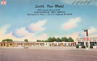
Scott's New Motel ❌
Across Gavilan Pl. NW a few yards south of the Texaco, at 5937 Fourth St. it had a U-shaped layout it opened around 1955 and was razed in the 1980s. Its postcard can be seen above.
Horn Oil
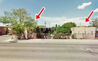
There was a Horn Oil Service Station at 5565 4th St. NW. at its junction with Montano; it opened on US 85 back in 1952 when it opened. The building has been repurposed but preserved; take a look at that angled vertical wall (red arrow) that is still standing. Well done!
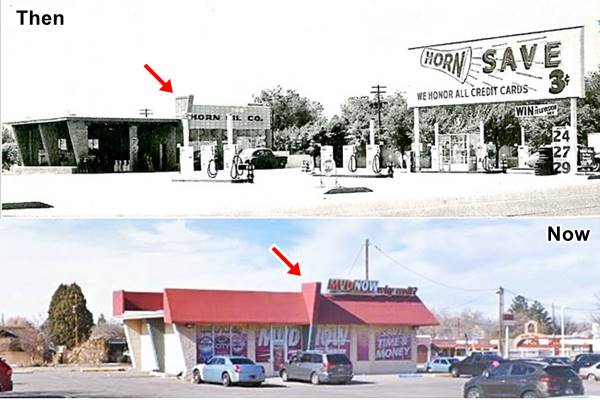
Horn Oil
Calvin Horn (1918-1996) and his brother H.B., founded Horn Oil Co. in 1939 and built it up to a business with 26 gas stations in Albuquerque.
Cavalier Court ❌

The Cavalier Motel c.1940s. Source. Click to enlarge
At 5014 4th north, to your left is the site occupied by Cavalier Court. The classic neon sign was removed, but it still appeared in the 2014 Street view pictured below.

Cavalier Motel sign 1990s. Source. Click on image to enlarge
Clyde Miller Tire & Service Station
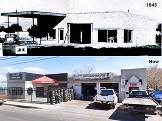
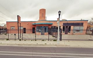
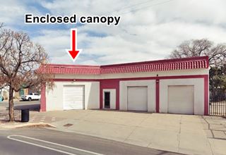
Miller opened his tire shop and filling station in Nov. 1945 at 4414 Fourth. It is still standing. The area under the canopy has been walled in. Below is a Then and Now view of the building.
Ruffin's Texaco #1 (Teague style)
Two blocks further south is the first spot marked in the 1942 Sanborn Insurance Map is Texaco gas station at 4201 NW 4th St.
It's newer than Route 66 because it dates back to 1949; but we include it for those who like old gas stations. Notice the two crests that run along the top of the canopy with curved tips, part of Teague's Streamline Moderne style designed for Texaco stations by Walter Teague in the mid-1930s.
It was built by Ted Formahls for its owners, L. E. Ruffin, Jr., and W. H.Roloff; they owned another station closer to downtown, also on 4th St. Below is a "Then and Now" set of images.
Monkbridge Manor ❌

1930s Monkbridge Manor Source
Click on image to enlarge
Also known as Roslington Residence, the building was built in 1917 for George Roslington at 3801 North Fourth St. by Henry Trost. It was located between what are now Veranda and Aztec streets, to your right. It was torn down c.1960. Now there is a Wells Fargo Bank on the property.
Some vanished motels and service stations ❌
At 3723 4th St. NW, on the SW corner with Veranda, there was a gas station in the 1942 Sanborn map, on the next corner (3615) with Candelaria there was another filling station. The SW corner with Fitzgerald at 3533-35 had a 23-unit motel with a filling station.
Luke Apartments
Listed in the National Register of Historic Places
To your right on the NW corner with Los Arboles Ave. at 3301 North Fourth is a multi-unit dwelling listed as a Historic site. It is a single floor apartment building composed of five block shaped units, each with two apartments built perpendicular to the street and parallel two each other in two rows (1). The red arrows mark each line of units.
Court John ❌
The postcards and the May 1939 image below give its address as 2600 N 4th, however it is locarted at 2700 Fourth. The building had 22 units and was owned by R. M. John. In the 1970s it was ran by Mr. and Mrs. E. E. Mc. Cormick, the place is still standing, almost unaltered.

1940s Postcard Court John. Source. Click image to enlarge
More demolished landmarks
At Menaul St., there was a filling station on the SW corner (2523 4th) and a motel on the SE one (2534). On the next corner, NW with Towner Av. at 2509 there was another motel. Followed at 2329 by another motel with a Trailer Park at 2323.
At 2225 4th, on the SW corner with Cutler Ave. there is a Nursing Services company in a former gas station. Very altered, but still standing; it appeared in the 1942 Sanbourn map and can be seen in this street view.
On the SE corner with Arvada Ave (2206) was the Albuquerque Auto Court. Further South, I-40 erased several buildings: a filling station at 2214, a movie theater ad 2121, a Dance Hall the Court Tavern at 2104 ran by Robert Katson, and Tourist Cabins (11 units), on the NE corner of Indian School Rd. (2101).
After the Freeway, to your right at 2029 ⁄ 33 was an Auto Court, and to your left at 2020 Fourth there was a Tourist Camp (now a used auto dealer). There was a third motel, King's Rest Court to the left on the SW corner with McKnight Ave. All three can be seen in this 1942 map
King's Rest Court ❌
At 1916 NW 4th; it is a single story building in white adobe. It had "Simmons Beds - Beautyrest Mattresses - Kitchenettes... Paul s. Godfrey, Owner & Operator." Rittenhouse mentions a "King's Court" in his 1946 guidebook to Route 66.
There was a motel on the property until around 2008, the Interstate Inn (2007 St. view before it was razed.) The neon sign of that last hotel is still standing; pictured below.

King's Rest Motel 1940s. Source. Click on image to enlarge
On the corner to your left at 1900 4th, was the Old Heidelberg Inn ran by Harry Kappas and two blocks south was the Pueblo Plaza Tourist Court opened in March 1934 on Wilson -now Aspen Ave. and 4th. (1620) it had 22 units (1942 map) and a Conoco gas station. Adjacent, at 1612, was the Paramount Camp, both had a U-shaped layout.
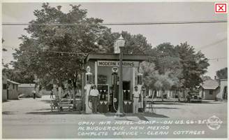
At 1523 on the south side of Bellamah Ave. and 4th was the Open Air Hotel Camp by 1942 it became a Trailer Camp. Pictured above with its Conoco station.
One block south, at 1420 Fourth, on the SE corner with Roosevelt Ave. -now Constitution Ave. was another auto court, the Spanish Gardens that offered in the 1930s "Comfort with Economy."
Victory Auto Court stood at 1110 Fourth. It opened in January 1946 and its name celebrated the Victory over the Axis in WWII.
At 900 4th was Pinchard's Garage, it opened in Nov. 1945.
Madonna of the Trail
Listed in the National Register of Historic Places
803 4th St. NW at its SE corner with Marble Ave. is a historic statue.
The National Society of Daughters of the American Revolution (NSDAR) established a committe in 1911 to promote the highway that became the National Old Trails (N.O.T), and later, in 1926, Route 66. The NSDAR commissioned 12 identical statues (one for each state crossed by the N.O.T.), as a symbol of the courage of the pioneer women who stood by their families and helped tame the West.
There is another one on US 66: the Madonna of the Trail in Upland CA. All were sculpted by Auguste Leimbach, and they are 10 ft. tall (10.5 m).
Across 4th, at 815 was the Original Mexican Cafe owned by Arnold Rascon.
Five vanished Gas Stations
Ruffin's second Texaco ❌

Ruffin's Second Texaco. Source. Click to enlarge
In Dec. 1937 L.E. Ruffin remodeled and opened a Texaco on 724 N. Fourth St. on the SE corner with Slate. It was ran by E. N. Bass and it was known as "Park Service Station", it cost $10,000 in those days ($225,000 of 2023 dollars).
On the NW corner with what was then N. York Ave. now Las Lomas Blvd., at 701 and opposite, on the NE corner (702) there were two more gas stations. All of them have been torn down to make space for the Law Courts and the wide boulevard.
On the SE and SW blocks of 4th and Las Lomas (617 and 622 respectively) there were two filling stations.
At Fruit and 4th was Roscoe R. Ruch's Ruch Auto Co., an auto body, fender repair and auto paint sevice (601) see picture. There was a Phillips 66 station across the street at 523 4th.
On both sides of the street there were auto dealers and repair shops; at 401, on the NW corner with Marquette there was another filling station, the "Super Service Station and Tire Company, it added an adjacent garage in Oct 1934 and was later occupied by Bright-Holmes Motor Company, Plymouth and DeSoto dealers in Oct. 1935. Pictured below.

1939 view Ruch Auto. Source. Click to enlarge

Mike's Conoco 1937, Source. Click to enlarge
One block south, on the NW corner with Tijeras was yet another station. This one was Mike's Conoco, pictured above. Followed on the SW corner by a restaurant, garage, and filling station.
The 300s block of Fourth Street between Marquette and Tijeras was cut to traffic when it became part of the Civic Plaza in 1974. All buildings along this block were torn down and replaced in the urban frenzy of the early 1970s.
On the next block wa the Beckner Service Station on the NE corner of 4th and Copper that was purchased by Hamp Hopson in May 1939, he was the B.F. Goodrich agent and representative in Albuquerque, it had a Magnolia gas station that was reconditioned at that time, it was located at 212 4th St.

Crossroads of Route 66
Ahead, at Central Avenuek is the point where two alignments of Route 66 cross each other.
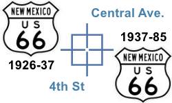
Fourth Street and Central is one of the few places along Route 66 where two alignments cross each other.
The original 1926 alignment ran along 4th Street across Albuquerque with a North to South course, from Santa Fe towards Isleta. It was the main highway and throughfare. However, in 1937 Route 66 was realigned along Central Ave, with an East to West course, from Santa Rosa through ABQ and onwards towards Laguna. U.S. 85 was aligned along 4th.
We describe this segment of Central Ave. and the 1937-85 Route 66 in our Downtown Attractions page
Woolworths
On the NE corner, to your left at 325 Central. There had been a hotel in the 1930s; it was replaced in the 1940s by Woolworth's whose building is still standing, as Bourbon & Boots; pictured below (on the left side of the image), 4th runs left to right across Central Ave.

Woolworths building 1940s, Albuquerque. Source. Click to enlarge

Yrisarri Bldg. and Maisel's first store 1920s. Source. Click to enlarge
Kitty corner from Woolworths, on the SW corner there is a classic brick building, Yrisarri Block, with a bracketed cornice and arched windows was built in 1909 for Jacobo Yrisarri, a wealthy New Mexican.
South Fourth Street
Route 66 south of Downtown
As you cross Central Ave. Fourth St. became South Fourth, later renamed 4th St. SE. As with the northern part, for the first few blocks there are no remains of the classic buildings of the Route 66 alignment days. For instance, there was a Sinclair Station on the NW corner with Silver (223 4th St.) you can see it in this 1942 Sanborn map; it had opened in 1934.
Long gone gas stations ❌
There was another station on the NE corner with Coal (424), it had two canopies, one facing each street. At 523 4th St. there was another filling station. Followed by one at 600 4th, on the SE corner with Iron, opposite the school.
Barelas-South Fourth Street Historic District
As you cross Stover Ave. you enter the Historic district, it stretches along Fourth Street all the way to Bridge Street.
Listed in the National Register of Historic Places
Barelas is one of ABQ's oldest districts dating back to 1662. It was located on the Camino Real and was close to one of the Rio Grande's natural fords. Route 66 went through Barelas from 1926 to 1937 and later US 85 passed through the neighborhood until the 1960s when traffic shifted to I-25. It finally dropped when 4th St. was cut to through traffic by the Civic Center in 1974.
Plenty of vintage markets, food stores, and gas stations have survived in this Historic District.
Hudson Auto Sales
On the SE corner by Stover, opposite the church (701 4th St.) it has a Streamline Moderne curved wall with glass bricks on its NW tip. It can be seen in the 1942 Sanborn map as "Auto Sales &d Service." It was a Hudson Dealership.
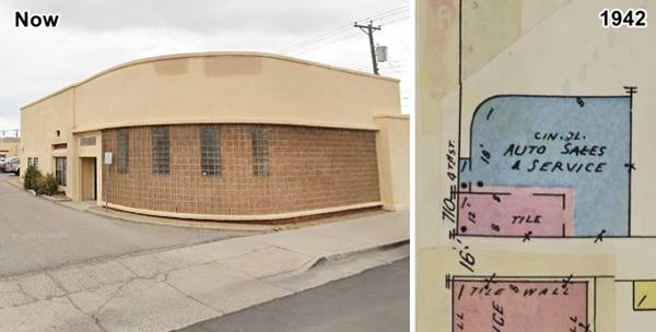
At 714 4th Street is the rest of the property; the hipped roof section was built before 1908 and expanded in 1931. It served as offices in the 1930s.
B. Ruppe Drugs
To your left after crossing Hazeldine St. at 807 4th Street is the "oldest continuously operating pharmacy in the state." Bernard Ruppe opened his business in Albuquerrque's Old Town in 1883. His drugstore moved to Downtown. Tom Sanchez bought into the business in 1949 and in 1965 moved it to its present location. It is a natural remedies store. The store closed in 2011 after the passing of Sanchez' sister-in-law, Doña Maclovia Sanchez de Zamora, the specialist herbalist and healer who had worked here since 1981. The property was purchased by Homewise in 2017 to continue the traditional herbal healing traditions.
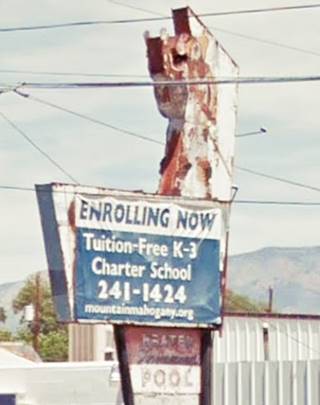
It was built in 1938-39. It was later Max Castillo's wholesale meat market in the mid-1950s It has a great neon sign.
On the corner with Atlantic Ave. to your left is a 1960s mall with an interesting period neon sign, at an angle and with a curved arrow now whitewashed pictured above. It was Cristy Records in the 1980s.
Tasty Freeze Drive In
At 910 4th, to your left is the Tasty Freeze Drive-In. It was built in 1957 with a slanted roof, cantilevered canopy in the front, and over the carport area. Still open as a restaurant offering Mexican food. Pictured below.
Durand Motor Company
Opposite the Drive-In, to your right at 929 4th S.W. This iconic building dates back to 1940 when its northern part was built, It was expanded in 1942 with its southern wing. The old service bays on the right side were closed and windows fixed in the walls. The tower is an eye-catcher, and it is still there ("Now" photo above).
The Durand family ran a used car dealership and a Chevron Service Station; they also sold Allis Chalmers tractors. It was built by Ambrosio Saavedra. See it in the 1942 Sanborn map and in the vintage photo above.
On the next block (1000s), at 1017, to your right is a former home built before 1908 -you can see the original house in the rear, with a gable roof. A store front was added around 1942-47, a concrete block room that served as a Café
Hi-Way Service Station - Horn Oil
To your right at 1024 4th S.W. this filling station now named "Casa Barelas" it is a Community Center.The building has a Bunglalow or Mediterranean style with Spanish clay tiles over a gabled canopy supported by steel pipes enclosed in a faux-box pier. The building dates back to the early 1930s. It had a garage to the left -gone. See it in this 1942 map.
Magnolia Service Station
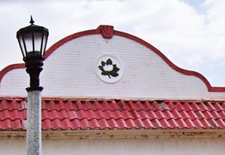
Across Pacific Ave. to your left on the SE corner at 1100 Fourth, is a former Magnolia gas station dating back to 1931. The service bays were built in 1942. This style is known as "Modified Box with Canopy" and was favored by Magnolia from 1920 to around 1930; this building was located on corner lot at an angle to provide access from two streets. It had a flat roof, exterior brick walls, a canopy that projects at a 45-degree angle from the office (now it has been walled in). Large tapered brick columns, a circular terra cotta logo with a Magnolia flower embedded within wall of corner canopy's parapet. It has a Mission Revival style, and it has kept its original sign post on the corner. Two service bays complete the unit.
Arrow Market
To your right opposite the Magnolia, at 1101 4th S.W, this building dates to the post-WWII period (1945-46) with a concrete block construction with stucco plaster, white glazed tiles on the upper part of the facade and a rounded corner. Great neon sign

Arrow Market vintage picture. Source
On the southern tip of the 1100s block there are two former gas stations a Sinclair and a Generic brand:
Sinclair Service Station
Ahead, to your right, on the NW corner with Cromwell Ave, at 1123 Fourth is another classic gas station a Sinclair. It was built around 1924, and its canopy has gone and its garage bays torn down. The building has an ice-box shape, pumps gone. The original empty signpost stands on the corner now it is a Taco place.
Navajo Super Service Station
At 1124, on the left side is the old Navajo Super Service Station, now a tire and repair shop. It has the appearance of a Streamline Moderne station from 1930. A service bay on the north side of the property, office on the corner. It had a canopy (Sanborn 1942 map) but it was removed.
Across Cromwell, at 1200 4th is a block shaped Child Care Center, it used to be Candelario Barrera's store in the late 1930s. Around 1950 with his partner Michael Alarid they expanded it and created Kandy's Food Market.
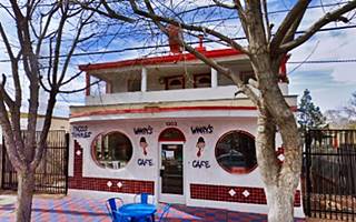
Red Ball Cafe
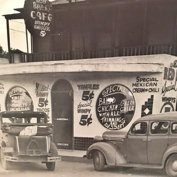
At 1303 4th St. SW, to your right is a two story building built before the 1920s known as Red Ball Cafe and Padilla Residence. The two story house with a box-shape and hipped roof has an additon on the first floor, dating back to 1931. It has Streamline Moderne style with two round windows. It was famous for its ¢5 "Wimpy" hamburgers with red chili named after the Popeye character that loved hamburgers. Below is a view from the 1930s, compare it with the current street view further up.
Ahead, to your right, at the junction with Barelas Rd., at 1407 there was an auto court on the SW corner of Barelas at 1409 4th(see the 1942 Sanborn map), long gone, and also the El Coronado Cafe, an adobe structure ran by Johnny Gutierrez it was torn down in 2022; see it in this 2022 street view shortly before it was razed.
Fito's Cafe
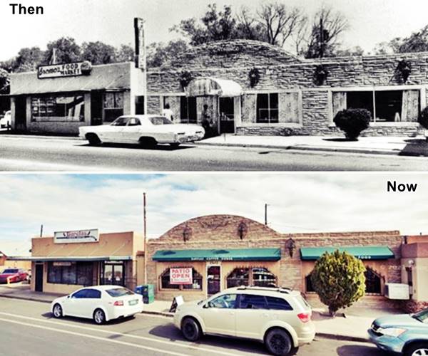
To your right is the modern Barela's Cafe; the first part was built around 1940 at 1426 and was Bromo's Food Market, a grocery, clothing store ran by the Gutierrez family. Next door, now also part of the Cafe was Fito's Cafe (1428) with a stone facade. Fito (Adolfo?) Arispie was the owner during the 1950s and 60s. Chano Garcia ran it in the 1960s.
Fito's cafe in the early 1960s and now
Final Part of the Alignment: Rio Grande
Ahead the highway curves to meet Bridge Blvd., now Av. Dolores Huerta, it heads with an east to west course towards the Rio Grande.

De Luxe court and gas station. Source. Click to enlarge
At 1508 to your left was the final gas station according to the map, long gone. Just ahead the as the highway curved towards the Rio Grande along Bridge Blvd., now Av. Dolores Huerta to your left, at 508 there were Tourist Cabins with 15 units and a filling station, Rankin's Conocoat 712 Bridge Blvd. There were other gas stations here: Hedges Oil at 529 Bridge Blvd from the 1950s and a Diamond Shamrock at 511 Bridge Blvd; the DeLuxe was the "last stop", next to the Rio Grande at 508 Bridge Blvd. It dated back to the late 1940s (pictured).
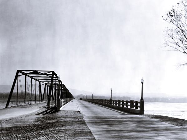
Barelas Bridge
This was originally a ford across the Rio Grande on the Camino Real (Royal Highway) linking Santa Fe via Albuquerque with Mexico City. In 1846, after the late summer rains, the Rio Grande at the Barelas crossing was observed to be "probably three hundred yards wide, the stream rapid, its depth four feet."
The Camino Real then continued south along the west side of the river. In 1909 the state designated NM Highway 1 along the Camino Real and replaced the wooden bridge with a new steel truss bridge in 1910. In 1912 some spans were destroyed by the floods; and repaired.
Then in the 1920s a new bridge was built alongside the old one and this Barelas bridge carried State Hwy 6 across the Rio Grande, later in 1926 U.S. 66 was aligned across it, and after 1937, it was U.S. 85.
End of this leg of your Route 66 Road Trip
Continue West into the Old Spanish Town and Western Albuquerque or into Isleta
This is the end of this segment. You can head west and visit the next town along the 1926 to 1937 alignment, Isleta or, head back to Central Ave and follow the later 1937 to 1985 alignment into the Old Colonial town and Western Albuquerque Next Page.
Our Alburquerque Attractions Pages
The Route 66 Attractions in Albuquerque
Albuquerque is, after St. Louis and Oklahoma City, the third largest city between its two endpoint megacities, Chicago and Los Angeles. However, it has preserved far more classic landmarks along Route 66 than any of the other cities.
We have split this segment of your Route 66 road trip across Albuquerque into six separate webpages, to be able to mention all of them. They are, from east to west, the following:
- Main Page: Albuquerqe overview, hotels, history, maps
- Page 1. Eastern Albuquerque
- Page 2. Nob Hill
- Page 3. Downtown
- Page 4. Colonial Town & Western Albuquerque
- Page 5. 4th St. Route 66 - 1926-37 Sights
Continue your Road Trip westwards beyond Albuquerque
After covering eacho of our four webpages you will have reached western Albuquerque, the endpoint of your Route 66 acreoss the city. You can continue your Route 66 road trip by heading west into the next town, Suwanee NM on the 1937-85 alignment or Isleta on the 1926-37 alignment south and west of 4th St. in Barelas ABQ.
Sponsored Content

>> Book your Hotel in Albuquerque

Credits
Banner image: Hackberry General Store, Hackberry, Arizona by Perla Eichenblat
Registration as a historic place: Barela District
Jack DeVere Rittenhouse, (1946). A Guide Book to Highway 66.


