Where Route 66 reaches the Mississippi River
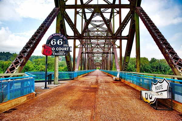
The Chain of Rocks Bridge
Index to this page
All about Madison, Illinois
Trivia, Useful Information & Facts
Elevation: 426 ft (130 m). Population 3,891 (2010).
Time zone: Central (CST): UTC minus 6 hours. Summer (DST) CDT (UTC-5).
Madison is a city in Madison County, Illinois, United States both, the 1926-40 and 1940-54 alignment of US-66, (Map of Madison).
History of Madison
Humans have lived in Illinois since the retreat of the glaciers at the end of th last Ice Age some 12,000 years ago.
Visit our Mitchell History webpage for the early history of Madison County.
The first post office in the area where the city of Madison is now located opened on May 17, 1841. But only fifty years later, in 1891, was the town platted. This was the third town named Madison with that name in Madison county, and the only one that survived.
Merchants of St. Louis chose to set up factories in Illinois to avoid the toll and cost of moving coal across Eads Bridge into Missouri. Soon they formed the Madison Land Syndicate and built a rail bridge across the Mississippi River "Merchants Bridge", which opened in 1898.
The Missouri Car and Foundry Company, Standard Oil Company soon opened their plants there. Its population grew with the industry that built their factories in the area.
Together with neighboring Venice they provided labor for the St. Louis Stamping Co. and Granite Iron Rolling Mills that were located in neighboring Grainte City (founded in 1896). Together they formed the Tri-Cities area.
Population peaked at 7,000 in 1970 but the loss of jobs, and rust-bucket economic situation led to a loss of population.
The Name:Madison
The city was named after the county, which in turn was named for James Madison Jr., Founding Father and fourth President of the USA (1809 to 1817 serving two terms). Born 1751, Died 1836. The English surname means "Son of Maud", and Maud is the diminutive of Matilda or Magdalen.
Reaching Madison
Drive into Madison along Historic U.S. 66. You can also use the freeways that lead to St. Louis: I-55, I-64, I-70, and also Historic US-40.

Where to Lodge in Madison Illinois
Find your Hotel. Lodging & accommodation in Madison is rather limited, but you can find hotels in Granite City.
> > Book your hotel nearby in Granite City
More Accommodation near Madison on Route 66
Below you will find a list of some of the towns along Route 66 east and west of this town; click on any of the links to find your accommodation in these towns (shown from east to west):
Along Route 66 in IL
- Hotels in Illinois
- Route 66 Starting point ▸ Chicago
- Lockport
- Willowbrook
- Bolingbrook
- Plainfield
- Romeoville
- Joliet
- Wilmington
- Dwight
- Pontiac
- Chenoa
- Normal
- Bloomington
- Atlanta
- Lincoln
- Springfield
- Raymond
- Litchfield
- Staunton
- Williamson
- Hamel
- Edwardsville
- Collinsville
- Troy
- Glen Carbon
- Pontoon Beach
- Granite City
- East St. Louis
West in Missouri
- Hotels in Missouri
- Florissant MO
- Bridgeton MO
- St. Louis MO
- Kirkwood MO
>> Check out the RV campground in neighboring Granite City
Weather in Madison Illinois
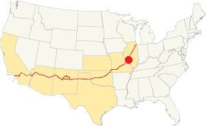
Location of Madison on U.S. Hwy. 66, Illinois
Madison's average temperature can range from a low of 19 °F (−7 °C) in winter (Jan) to a high of 90 °F (32 °C) in summer (Jul).
Extreme values that have been recorded are: a chilly −16 °F (−27 °C) in winter and a suffocating 114 °F (46 °C) in summer. The average monthly precipitation is 2 inches (51 mm) in January and 4.24 inches (108 mm) in May.
Tornado risk
Madison is in an area that is struck by some 7 tornados every year. Tornado Risk: learn more about the Tornado Risk on US 66.
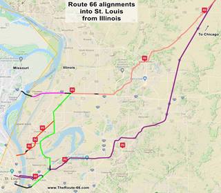
Map of Route 66 through Madison
Click on the Map to see a large sized map showing Route 66 alignments that go into St. Louis MO from Illinois.
This is the color key for the map:
Orange: is first, it shows the original 1926-32 aligment of US66 through Madison and Venice into St. Louis MO.
Pink is the Bypass US-66 that crosses the Chain of Rocks Bridge in the north side of the city of Madison.
Green, and the other colors (Salmon, and Yellow) show different courses taken by US 66 over the years.
Violet, the latest 1954 alignment from Hamel through Troy and Collinsville.
Black: missing segments that can no longer be driven.
Historic alignments in Madison
The following map was published in 1924 (two years before Route 66 was created) and shows the "auto trails" of that time, roads that could be "safely" driven in a car. The road marked "13" was the "Mississippi Valley Highway" and the one marked "66" was the "Mississippi River Scenic Highway". State Highway 4 shown as (4), all went through Madison -in the middle of the map, beneath Granite City.
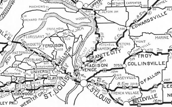
1926-29 Route 66 crossing McKinley Bridge
In 1926 Route 66 was aligned along State Route 4 from Hamel to Venice. After passing through Edwardsville it turned south at Mitchell along IL-203 (Nameoki Rd.) and then the western side of Granite City via Edwardsville Rd.
At Madison Avenue it turned southwest going through Granite City proper and then continuing along Madison Ave., where it entered Madison. This alignment is shown with the Blue arrow in the map below.
US 66 then went along Madison Avenue through Madicon city, entered Venice along Broadway and crossed the Mississippi River on the McKinley Bridge. This is the Map of the 1926-29 US66 in Madison, that can be driven. Actually the original road ran straight west along Broadway, but this is now cut by the railroad -at that time a grade crossing- and Fourth St. So you have to turn north and then south along Cedar to reach the bridge. See this Map of the missing part of Route 66.
1929-35 alignment South of Madison to the Municipal Bridge
In 1929 this changed and Route 66 took a southwards course through Venice, Brookyln and into East St. Louis, to cross the Mississippi along the "Municipal Bridge" on the south side of St. Louis. This alignment has some missing segments, so there are three maps to show it:
- Map 1 Madison to 10th St. in East St. Louis
- Map 2 E. St. Louis to Piggott Ave.
- Map 3, crossing Municipal Bridge (now closed to car traffic).
So the original 1926 alignment using McKinley Bridge became the Optional 66 highway.
Then on July 20, 1929 the Chain of Rocks Bridge was opened to traffic, the Illinois side west of Edwardsville, through Mitchell was paved and ready to carry Route 66, bypassing the cities (Madison, Granite City, Venice) to the south, but as the Missouri side of the bridge wasn't yet ready Route 66 only moved to Chain of Rocks in the mid 1930s.
City 66 in Illinois
At that time the older alignment through Madison became City 66 and by 1940 had been realigned on the eastern side of Madison (Red arrow in the map below).
Below is a 1940 USGS map of Madison, with City 66 running on the right side of the town together with Alt US 67 along Mc Cambridge Ave. (IL-203) and then on Madison Rd., all the way to Collinsville Rd. to go through East St. Louis and cross the Mississippi River along the Municipal Bridge, into St. Louis.
USGS map from 1940 with US 66 in Madison, Illinois
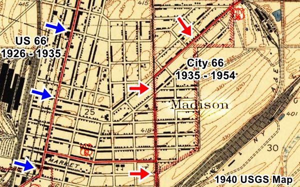
These maps show the alignment of "City 66":
The City 66 then met the older alignment and continued as shown in Map 2 and Map 3, further up, to cross Municipal Bridge into St. Louis.
1954 Realignment
Route 66 was realigned later in 1954, through Collinsville (violet in the map further up).
The Route 66 alignment in Madison
Visit our pages with old maps and plenty of information about US 66's alignments.
- Route 66 St. Louis to Gray Summit (next)
- Route 66 Hamel IL to St. Louis MO (In Madison)
- Springfield to Hamel IL (1930-77 previous)
- Springfield to Staunton IL (1926-30 US66 previous)
Madison's Route 66 Sights
Sponsored Content
Attractions & Landmarks
Safety Tip: Crime rate is high
Use common sense in this town: just like in East St. Louis and St. Louis: ONLY VISIT the Route 66 sights DURING DAYTIME and then move on to stay in accommodation outside the city. Both East St. Louis and St. Louis and the shabby districts around them, have a very high crime rate. It is not adviseable to spend the night there.
Drug abuse and crime rates are high. Keep off the streets at night don't leave valuables in your car, and know exactly where you are going because you don't want to get lost or end up in a nasty neighborhood.
Not many Route 66 attractions have made it to the XXIst century. There are many vacant lots, boarded shops, abandoned buildings in Madison. Many of its Golden Days Route 66 sights have gone, but there are a few survivors! that we consider worth seeing in Madison.
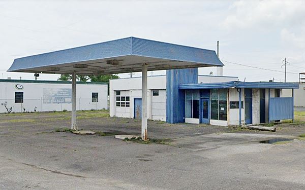
Old 1950s Shell station
We will drive through Madison, entering town from the east (Granite City) along the 1926 Route 66. To your right, as you leave Granite City, on the NE corner of Madison and 15th St.
This is a 1950s Shell service station. The vertical element in the middle and the short cantilevered canopy across office and across side with restrooms was typical of Shell stations of this period. This one has two garage bays, and a separate canopy over the pumps island.
Orthodox Church
At 13th St., turn right and one block north of Route 66 is the Bulgarian Eastern Orthodox Church in America. It was the first in the US: the Bulgarian Orthodox church board in Madison was organised in 1906. (on the corner of Grand Ave and 13th St. Street view. Head back to Madison Ave. and continue west.

Detail of the Post Office Mural
Click image to enlarge
Source
Post Office and mural
Drive into Madison, you will reach the Post Office at 549 Madison Ave., to your right, a red-brick building with white stone details. It was built in 1936 under the New Deal program. In the lobby you can see a "mural" by Alexander Raymond Katz (1895-1974) a Hungarian born American artist. He painted in in 1940, using oil on canvas. The work's title is "Assimilation and Immigration into Industrial Life of Madison", and depicts workers, farmers, train wagons, industrial and urban settings, with homes, factories and even churches.
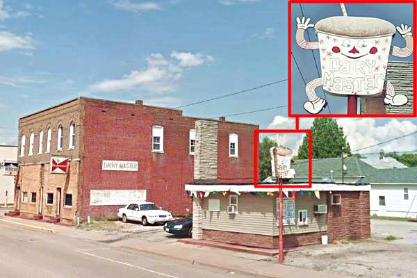
Across the street, to your left is the former Dairy Master.
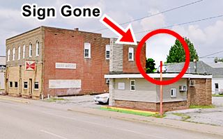
Dairy Master neon sign
516 Madison Ave, Madison. It used to have a great neon sign atop the now empty steel pole on the western side of the property. It was an "antropomorph" cup with a straw is a great example of Route 66 Kistch! But unfortunately it has vanished.
Dairy Master when it still had the now "vanished" neon sign in Madison, Illinois
Ghost Sign and Pace Hardware Neon sign
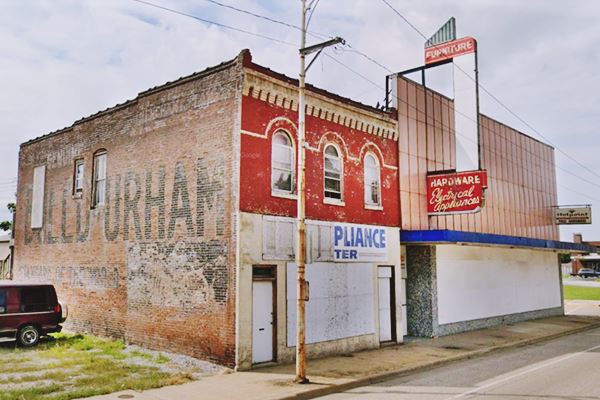
Drive west and on the corner of 5th and Madison is an old hardware store with a classic neon sign and a "Ghost Sign" on its western wall.
The ghost sign is a "Bull Durham" advert, a "smoking" tobacco, whose slogan was "Best for three generations". It was produced in Durham, North Carolina by W.T. Blackwell and Co. between the 1850s and 1988.
Pace & Sons Enterprises Inc was founded in 1936 in Madison and operated hardware stores.
What is a Ghost Sign?
A ghost sign is an advertisment painted on a brick wall from the late 1800s or early 1900s that has managed to make it to our days without being painted over or erased. Below is the Pace Hardware neon sign and Ghost Sign.
Madison Theater
Drive on, and take a left on Third St. Half a block south of Route 66, to your left is the old "Madison Theater" at 1537 Third St. Next to the city hall.
This red brick building dates back to 1913 by the local Fire Dept., which occupied the second floor. The Theater opened in 1930, and was on the first floor; it closed in 1960.
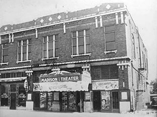
Vintage picture Madison Theater. Source

Current view of Madison Theater. Source. Click for St. View
1950s Gas Station
Continue west and visit a 1950s gas station, on the SW corner of Madison and 2nd St.
It is an oblong box gas station, the plate glass windows of the office have been boarded up, but you can see the white porcelain enamel panels on the walls, the two-bay garage, the pump islands and the stump of the station's sign. It could have been any brand, because many (Cities Service, Conoco, Gulf, Sinclair and Texaco, to mention a few) favored this type of design in the 1940s to 1970.
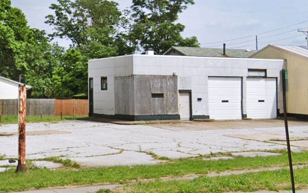
This ends your city tour of "downtown" Madison, you can head west into Venice cross the McKinley Bridge and enter St. Louis, or go north to visit the Historic Chain of Rocks Bridge, or take a short detour to visit the 1935-54 City 66 just east of here, only a 0.9 mile drive - see map.
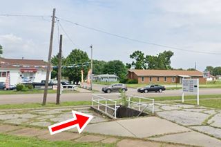
Pedestrian underpass
At Rhodes and McCambridge. It allowed pedestrians to avoid the dangers of crossing the busy City 66 highway.
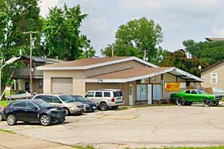
Ranch style gas station
One block east, where the highway curves, is a ranch style gas station from the 1960s (?) in good shape, open as a tire shop.
Historical Chain of Rocks Bridge
Due to the great extension of Madison city, it actually includes a Historic Site that is located on Bypass 66, well to the north (10 miles away - map). It is actualy closer to Northern Granite City on Bypass 66 (check out the motels and neon signs on this alignment) and Mitchell on BYP 66.
Listed in the National Register of Historic Places
It is one of the places were Historic Route 66 meets and crosses the Mississippi River.
Wayside Exhibit and the name of the bridge
The Old Chain of Rocks Bridge Marker has information about the Mother Road, the many bridges that it used to cross the Mississippi River, and why this bridge was named "Chain of Rocks" (there were rapids here, very dangerous ones formed by underwater rock outcroppings, the "Chain of Rocks").
Chain of Rocks Bridge nowadays in Madison, IL
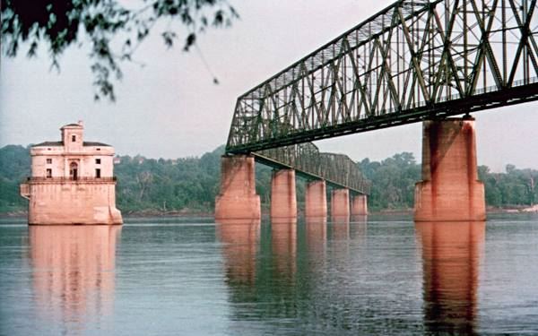
Below is a vintage postcard of the bridge, notice the tollbooth.
Historical Chain of Rocks, old postcard
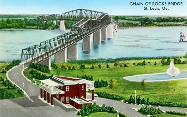
It was one enormous project in its day, and it was a private one. It was supposed to cost $1,250,000 (a fortune at that time, and ended up costing twice the original estimate).
It was suppposed to be straight, but ended up bended due to the complaints of riverboat crews because it was just next to the water intakes for St. Louis, and would have made navigation difficult. Also, the original straight course led it thorough bedrock that couldn't withstand the weight of the bridge. So it was "bent".

Wayside Exhibit at Chain of Rocks Bridge. Source
It stood 55 feet above the water and had a 40 foot-wide roadway with 10 spans.
Construction began in 1927 on both sides of the Mississippi and it opened in July 1929.
It carried Route 66 across it since then and in the late 1930s the Bypass US 66 was aligned across it to avoid going through downtown St. Louis. The bridge was initially a toll bridge but it was later removed.
In 1967 a brand new bridge, the "New Chain of Rocks Bridge" was built to the north and carried the freeway (I-270), this led to the demise of the Chain of Rocks Bridge that same year.
Tips for a Safe Visit to the bridge
Access to the bridge from the Missouri side is CLOSED due to severe issues with car vandalism. You can park on the Illinois access. Do not leave any valuables in your car. Park at your own risk. The bridge is open to bikers and pedestrians daily from 9:00am to dusk and is wheelchair accessible.
Bridge entrance is accessible in Missouri at North Riverfront Park, south of the Bridge along the Riverfront Trail.
Chain of Rocks Trivia
In 1981, the bridge was used to shoot a scene of the movie "Escape from New York".
It was the site of the 1991 murder of sisters Julie and Robin Kerry (Newspaper article).
Castles in the River
Next to the bridge, on its southern side are two amazing "Castles" which are intake towers that bring water into the St. Louis potable water plant. Back in the 1920s, crews would camp out there inside those four-story buildings to keep water flowing into St. Louis.
This is the end of your Madison City Tour. Head west into St. Louis and continue your road trip in Missouri.
Sponsored Content
>> Book your Hotel in Chicago

Credits
Banner image: Hackberry General Store, Hackberry, Arizona by Perla Eichenblat
City website cityofmadisonil.com
Route 66 in Madison County, Cheryl Eichar Jett. Madison Historical: The Online Encyclopedia and Digital Archive for Madison County, Illinois. 2019


