Index to this page
Hamel to St. Louis alignment
Illinois Route 66 Itinerary and maps
Each leg of Route 66 described below has an interactive map and many image maps so you can follow the alignments of the highway along the way:
- Chicago to Pontiac - Map of this segment.
- Pontiac to Springfield - Map of this segment.
- Springfield to Staunton (1926-30) - Map of this segment.
- Springfield to Hamel (1930-1977) - Map of this segment.
- This leg: Hamel to St. Louis - Map of this segment.
Missouri, next leg
Towns and alignments around St. Louis
These alignments went through the cities listed below, in the area that surrounds St. Louis in both Missouri and Illinois:
Route 66, the "1926-32" Alignment into St. Louis
< West - Gray Summit ¦
Wildwood ¦
Ballwin ¦
Manchester ¦
Des Peres ¦
Kirkwood ¦
Rock Hill ¦
Brentwood ¦
Maplewood - East >
Bypass Route 66 Around St. Louis
<SW - Kirkwood ¦
Creve Coeur ¦
Maryland Heights ¦
Bridgeton ¦
Hazelwood ¦
Mitchell ¦
Edwardsville ¦
Hamel - NE >
The Main Alignment of Route 66 west of St. Louis
<West - Gray Summit ¦
Pacific ¦
Allenton ¦
Eureka ¦
Times Beach ¦
Fenton ¦
Sunset Hills ¦
Crestwood ¦
Marlborough - East >
The Main Alignment of Route 66 east of St. Louis into Illinois
<West -
East St. Louis (Illinois) ¦
Venice ¦
Madison ¦
Granite City ¦
Fairmont City ¦
Collinsville ¦
Hamel - East >
Sponsored
Safety tips
Safety Tip - Crime rate in St. Louis and East St. Louis, Madison, Venice, Granite City
See the Route 66 sights during daytime and then move on to stay in accommodation outside the downtown areas close to the Mississippi Rivery. St. Louis and East St. Louis have very high crime rates and travelers don't feel safe to spend the night there.
The North Side of St. Louis lost jobs during the recession so you may encounter people who are potential drug users. Use common sense as you would in any large city. Park in a covered garage if you can, nevertheless you can park on the street in the town but only do so if visiting for a few hours and during daylight hours.

History: Before Route 66 existed (1924)
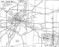
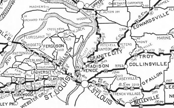
The following map was published in 1924 (two years before Route 66 was created) and shows the "auto trails" of that time, roads that could be "safely" driven in a car. The road marked "13" was the "Mississippi Valley Highway" and the one marked "66" had nothing to do with the future Route 66; it was the "Mississippi River Scenic Highway".
State Highway 4 shown as (4) would become Route 66. It came from Hamel and Edwardsville (upper right), through Mitchell and reached Granite City, Venice and Madison.
Hamel is a small community roughly 32 miles northeast of St. Louis. We chose it as the starting point of this segment because it was here, in Hamel that the different alignments of Route 66 start to split and take different courses.
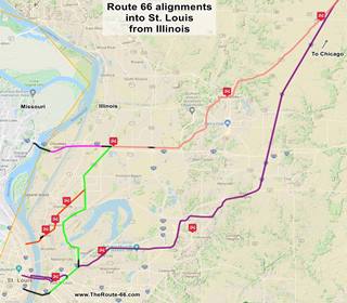
Click on the thumbnail Map to see a larger sized map showing Route 66 alignments that go into St. Louis MO from Hamel, llinois. Hamel is on the upper right corner of the map. Our custom interactive map shows the same alignments.
Route 66 From Hamel to St. Louis
At Hamel is the first fork in the alignments of the Mother Road into St. Louis, separating the original highway alignment (1926-54). It became BYP 66 after 1954.from the later one:
>> pale blue line in custom map shows the 1926-54 US66 from Hamel to Edwardsville.
The Main Route 66 was realigned to the south, through Collinsville in 1954 and remained so until 1977.
>> yellow line in custom map shows the 1954-77 US66 from Hamel through Collinsville.
Alignments split in Hamel
In 1954, Route 66 split into two alignments just north of Hamel at "Worden Wye" (there was a "Y" shaped fork here long ago), the junction of Route 66 with Possum Hill Rd. that leads to the town of Worden, 2 miles west and State Hwy. 4 which was the 1926 to 1940 Route 66 alignment.
See the map below and also view this 1955 aerial photo showing the junction that shows the work on the new roadway of the four-lane freeway under construction (now buried beneath I-55).
The 1954 map shows US 66 reaching the junction (upper right) and BYP 66 leaving it (lower left); the blue arrow shows Main 66. However, when the fork was built, it was located further south, at Green Hedge Rd. (the new "Main 66" hadn't been built in 1954 when the map was made). Later I-55 was aligned along this "new" four-lane roadbed.

1954 Map of US 66 near Worden, north of Hamel IL

1954 Map of US 66 alignments in Hamel IL
The map above shows the highways in Hamel: The original 1926-54 Route 66 ran through Hamel and in 1954 became the "Bypass 66", the new alignment on the right side of the map (further east) became the Main US66.
We describe these alignments in the following sections.
"Original" Route 66 west of Hamel
Hamel through Edwardsville to Mitchell
The first (1926) Route 66 alignment went from Hamel to Mitchell via Edwardsville. It is now State Highway 157. And it is shown in this map map from Hamel to Mitchell (18 mi).
There was a sharp curve west of Edwardsville at Ginger Creek Dr. that was altered in the early 1950s to make it wider. The old segment is still there (Map). Further ahead, the original junction with Bypass 40 was also modified:
US66 meets Byp 40
>> black line in custom map shows the junction of Byp 40 and US 66.

Historic Route 66 in 1948 and now (IL-157 & US66)
Rittenhouse mentioned a picnic spot at the junction of what is now Chain of Rocks Rd. (Historic US66) and IL-157. Back in 1946 this was where US 66 met BYP 40 & IL-157.
The map superimposes the current roadbeds with a 1948 USGS map; the same spot can be seen in this aerial photo taken in 1945 as a triangular grassy island between the highways.It was modified in the mid 1960s, and again in the late 1980s to its current configuration (satellite view nowadays): gas station and picnic area have been razed.
There is a cemetery and a there was a coal mine (Sunset Coal Mine, now closed) at the junction. After this point the highway ran in a straight line all the way to Mitchell, but some curves were built lateer to skirt around I-270 and I-255's exits 30 and 7B.
>> red line in custom map shows the alignment through Mitchell to the Chain of Rocks Bridge.
1926 Route 66: Mitchell to Granite City
At Mitchell it curved with a NE SW course along Nameoki Rd into Granite City, see this Map with directions of the 1926 alignment through Granite City (6.2 miles long).
>> orange line in custom map shows the 1926 alignment from Mitchell to St. Louis.
The highway followed what is now MO-203 (Nameoki Rd.), turning south along the western side of Granite City along Edwardsville Rd.
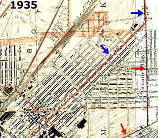
It is marked with blue arrows in the thumbnail map (click to enlarge), and with an orange line in our custom map. At Madison Avenue it turned southwest going through Granite City proper and then continuing along Madison Ave. into Madison (orange line in map).
Madison and Venice
This alignment is shown with an Orange line. See this Map with directions of the 1926-29 US66 in Madison. It can still be driven.
Actually, the original road ran straight west along Broadway, but this is now cut by the railroad -at that time a grade crossing- and Fourth St. So you have to turn north and then south along Cedar to reach the bridge.
>> black line in custom map shows the gap by the bridge in Venice.
McKinley Bridge
Here in Venice it reached the McKinley Bridge and used it to cross the Mississippi River into St. Louis and Missouri.
This bridge dates back to 1910, and was originally used by the railroad. It carried US 66 as from 1926 and was closed to traffic from 2001 to 2007. It has three spans with 18 panel Pennsylvania Petit Through Truss. You can still use it, it is open.
US66 beyond Mc Kinley bridge in St. Louis
After crossing the Mississippi River, the higway entered Missouri and the city of St. Louis.
Read about the 1926-30 alignment in St. Louis in our St. Louis Route 66 webpage and follow it in our custom map:
>> pale blue line in custom map shows the Driveable 1926 segment in St. Louis.
McKinley Bridge in Venice, Illinois
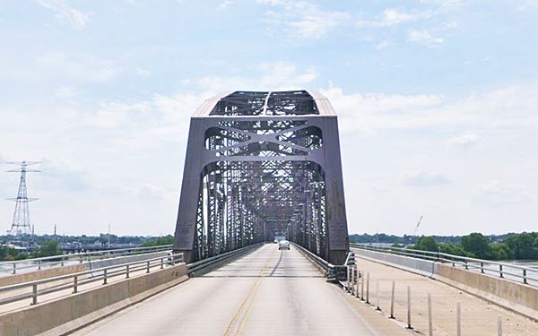
1929-35 alignment to the Municipal Bridge
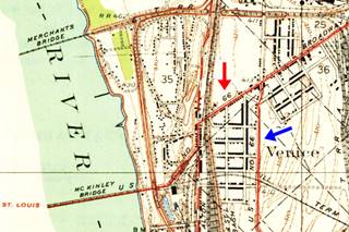
In 1929 the alignment in Venice IL changed. Route 66 took a southwards course through Venice, Brookyln, and headed into East St. Louis, to cross the Mississippi alongside the railway on the "Municipal Bridge" which was toll free. It is located on the south side of St. Louis. See map below:
>> pink line in custom map shows the 1926-35 Venice to Municipal Bridges alignment.
For those interested in driving, these are the maps with directions:
- Map 1 Madison to 10th St. in East St. Louis
- Map 2 E. St. Louis to Piggott Ave.
- Map 3, crossing Municipal Bridge (now closed to car traffic).
US 66 in MO West of the Municipal Bridge, in St. Louis
Read more about the 1930-50s alignment in St. Louis west of the Municipal Bridge, map below.
>> red line in custom map shows the bridge and the blue line, 1930 US 66 west of it .
Optional 66
So in 1929 the original 1926 alignment using McKinley Bridge became the Optional 66 highway.
Municipal or MacArthur Bridge
The bridge Opened in 1917 and carried a railroad, which still uses it. In 1929 US 66 used it. Car deck was closed in 1981 and dismantled in 2014. It has a steel viaduct on both sides of the river (picture below). The steel bridge has 3 spans: Modified Pennsylvania Through Truss with single-span Pratt Through Truss on its western tip.
1930s Chain of Rocks: "Second City 66" alignment
Historical Chain of Rocks Bridge
Listed in the National Register of Historic Places
On July 20, 1929 the Chain of Rocks Bridge was opened to traffic, the Illinois side west of Edwardsville, through Mitchell was paved and ready to carry Route 66, bypassing the cities (Madison, Granite City, Venice) to the south, but as the Missouri side of the bridge wasn't yet ready Route 66 only moved to Chain of Rocks in the mid 1930s.
A new segment of Route 66 known as "Main 66" or "Bypass 66" was built west of Mitchell and through the a place called St. Thomas on the northern part of Granite City. This segment existed from 1935 to around 1962.
>> red line in custom map shows the access to Chain of Rocks Bridge.
>> blue lines in custom map shows the gaps at I-270 in Mitchell.
It is cut by I-270 but it has two parts that can be driven as shown in our maps with directions: East side map (Thorngate Rd) and, on the west side of the freeway Bypass 66 map (Chain of Rocks Rd).
Then in northern Madison City, you can drive to the bridge along the old US66 roadbed as shown in this map with directions.
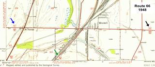
The USGS map published in 1948 below (click on it to enlarge) shows Route 66 reaching Mitchell (black arrow), City 66 heading south into Granite City (green arrow) and Route 66 heading west towards the Chain of Rocks bridge (blue arrow).
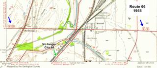
In the second map, published in 1955, It is BYP 66 that enters and exits Mitchell (blue arrows), the old City 66 had been eliminated becoming State Hwy 3 and Main 66 ran far to the east and south through Collinsville.
Chain of Rocks Bridge nowadays in Madison, Illinois
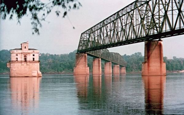
Below is a vintage postcard of the bridge, notice the toll booth.
Historical Chain of Rocks, vintage postcard in Madison, Illinois
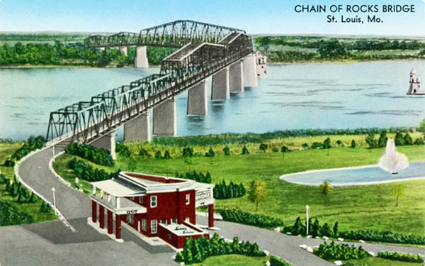
It was one enormous project in its day, and it was a private one. It was supposed to cost $1,250,000 (a fortune at that time, and ended up costing twice the original estimate).
It was suppposed to be straight, but ended up bended due to the complaints of riverboat crews because it was just next to the water intakes for St. Louis, and would have made navigation difficult. Also, the original straight course led it thorough bedrock that couldn't withstand the weight of the bridge. So it was "bent".

Wayside Exhibit at Chain of Rocks Bridge. Source
The bridge was named after the rapids formed by underwater rock outcroppings: the "Chain of Rocks" and it stood 55 feet above the water and had a 40 foot-wide roadway with 10 spans.
Construction began in 1927 on both sides of the Mississippi and it opened in July 1929.
It carried Route 66 across it since then and in the late 1930s the Bypass US 66 was aligned across it to avoid going through downtown St. Louis. The bridge was initially a toll bridge but it was later removed.
West of the bridge in Missouri: 1930 City 66 and the Bypass 66 in St. Louis
Follow the alignments west of the Mississippi River with our descriptions: First City 66 into St. Louis and the 1940s Bypass 66 in St. Louis. Maps below:
>> gray line in custom map shows the City 66 into St. Louis, the brown line is Bypass 66.
In 1967 a brand new bridge, the "New Chain of Rocks Bridge" was built to the north and carried the freeway (I-270), this led to the demise of the Chain of Rocks Bridge that same year.
Tips for a Safe Visit to the bridge
Access to the bridge from the Missouri side is CLOSED due to severe issues with car vandalism. You can park on the Illinois access. Do not leave any valuables in your car. Park at your own risk. The bridge is open to bikers and pedestrians daily from 9:00am to dusk and is wheelchair accessible.
Bridge entrance is accessible in Missouri at North Riverfront Park, south of the Bridge along the Riverfront Trail.
City 66 in Illinois
Second City 66
When the Chain of Rocks bridge opened, the original alignment through Granite City was renamed City 66, and called "second" to differentiate it from the one on the western side of the Mississippi that was St. Louis' City 66.
This took place around 1935 and ran through Granite City, Madison and Venice. By 1940 had been realigned on the eastern side of both Granite City and Madison. It is marked with a Red arrows in the 1940 USGS map of Madison below; it shows City 66 running on the right side of the town together with Alt US 67 along Mc Cambridge Ave. (now IL-203) and then along Madison Rd., all the way to Collinsville Rd.
>> green line in custom map shows the Second City 66 in Granite City and East St. Louis.
USGS map from 1940 with US 66 in Madison, Illinois
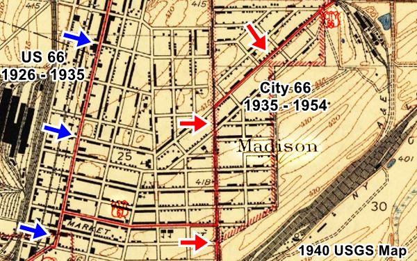
Below you can see the former City 66 (red arrows) from upper right (close to Edwardsville), through Granite City, to lower left (Fairmont City).

US 66 from Edwardsville to Fairmont in 1949. USGS Map

City 66 junction with Collinsville Rd in satellite view and 1940 USGS Map
click image for satellite view
Route 66 with Alt US 67 followed the alignment shown in this map with directions and reached Collinsville Rd. The final segment was built over by I-55 and erased, map below:
>> black line in custom map shows the Gap at I-55 and Collinsville Rd.
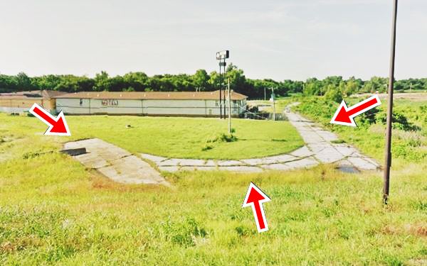
However, as you can see in the image that combines a satellite view of its present appearance (the red arrows show the old roadbed) and a 1940 USGS map show that some of the original road is still there.
Further down is a view of the remaining roadbed that has survived.
View of former US 67A and US 66 from Exit 4 of I-55 in Fairmont City, Illinois
Towards Municipal Bridge
Here the City alignment went west along Collinsville Rd., (there was no I-64 in those days) into East Saint Louis, and at St. Clair Ave. went southwest along 10th Ave. to cross the Mississippi River along the Municipal Bridge, into St. Louis. This is marked with a green line in this map.
>> green and pink lines in custom map shows the access to Municipal Bridge.
For those who want to drive Second City 66, below are some maps with directions:
1954 Realignment: "Main US66"
The final Route 66
As mentioned at the top of this article, Route 66 was realigned once again in 1954, from Hamel through Collinsville and Fairmont City.
>> yellow line in custom map shows the 1954-77 US66 from Hamel through Collinsville.
This was the final Route 66 realignment and it definitely bypassed Granite City and Madison. "City" Route 66 ceased to exist between the Chain of Rocks Rd. at Mitchell and Collinvsille Rd. The southern section became ALT US 67 (map with directions of the eliminated US66 section).
1954 US 66 West of Fairmont
The 1954 highway followed the old "City 66" in Fairmont, but instead of using the Municipal bridge, it took a new course at at St. Clair Ave. in East St. Louis. Here it turned right and then left becoming a 4-lane highway which then split into two separate options (see image below), that allowed the traffic to cross the Mississippi River using two different bridges: Veterans Memorial Bridge of Martin Luther King Bridge to the north and Eads Bridge to the south; both were toll bridges.
Modern I-55 has cut off one of those access routes at Missouri Ave. so another route must be taken to reach it from old Rte. 66 (see map c with directions, further down). The access to both bridges is also shown in our interactive map:
>> violet line and red line in custom map shows the access to MLK and Eads bridges.
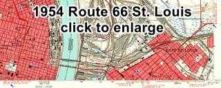
1954 USGS Map of US 66 into St. Louis
Click on the thumbnail map image to see a full size version. Main Route 66 coming from Collinsville (blue arrow right side of the map) reaches the old City 66 from Granite City (now ALT US 67 -green arrow upper right side of the map), it heads toards the Mississippi Rive (blue arrow lower right) crossing the Bridges into St. Louis. On the left-center side US 66 reaches St. Louis and the original City 66 coming from Chain of Rocks Bridge (blue arrow upper left).
It turns to head westwards out of St. Louis (blue arrow lower left). You can also see how US 40 and US 66 shared the same alignment into St. Louis.
Below are the maps with directions showing how the Main 66 crossed the Mississipi from East St. Louis.
- Map a Route 66 crossing Eads Bridge
- Map b Route 66 original crossing Martin Luther King bridge
- Map c current access from Route 66 to Martin Luther King bridge
- Veterans Memorial Bridge, to the north. Built in 1951, it was renamed after Martin Luther King Jr. in 1968. This steel bridge is a Cantilevered Subdivided Warren Through Truss with a 2-span Warren Deck Truss approach. It is open and you can drive across it. Its eastern approach in Illinois, from US66 along Missouri Ave. was cut off by I-55 (in Black in the map).
It was restored in 1987 and now has two eastbound lanes and one westbound lane. - Eads Bridge, 800 feet to the south of the other bridge. It was named after its designer and builder, James B. Eads and built between 1867 and 1874. It was the first bridge across the Mississippi south of the Missouri River. It is an Arch bridge 6,442 ft long (1,964 m).
The alignment West of the Mississippi River
Once across the river, the traffic headed west along Washington Ave. and met the Missouri City 66 which and headed west as Main US66.
Read our description about the 1932-77 "Main US 66" west from downtown St. Louis. The maps of the alignment is below:
>> blue lines in custom map shows both bridges, and the gray and light blue one is 1932-77 US66 leaving St. Louis.

End of this Leg
The leg from Hamel to St. Louis ends here, you will have to head head west into Missouri and St. Louis to continue your Route 66 Road Trip westwards, see below.
Next Section
Previous Section
Springfield to Hamel (1930-1977)
Springfield to Staunton & Hamel (1926-30)
Credits
Banner image: Hackberry General Store, Hackberry, California by Perla Eichenblat
Jack DeVere Rittenhouse, (1946). A Guide Book to Highway 66


