Route 66 in Cubero NM
Index to this page

TheRoute-66.com is reader-supported. When you buy through links on our site, we may earn an affiliate commission at no additional cost to you.
About Cubero, New Mexico
Facts, Trivia and useful information
Elevation: 6,217 ft (1.895 m). Population: 289 (2010).
Cubero is a small village in Cibola County New Mexico, on the original 1926 Route 66 alignment. With part of the Villa de Cubero on the later 1937-70s alignment.
Time zone: Mountain (MST): UTC minus 7 hours. Summer (DST) MDT (UTC-6).
History
New Mexico has been inhabited for the last ten thousand years. These first inhabitants later evolved into the Native American Pueblo people who lived in the valleys of the rivers that flow from the Rocky Mountains into the Rio Grande Basin such as the San Jose River. They used the water to irrigate their crops of maize, squash and beans.
The first Europeans to explore this area were the Spanish of Francisco Vásquez de Coronado's expedition in 1540 who visited the nearby Acoma Pueblo. In 1589 they conquered Nueva Mexico and established missions to convert the Pueblo to Catholicism. Tired of being oppressed the natives expelled the Spaniards during the 1680 (Pueblo Revolt), but were reconquered once again in 1692.
The native name for Cubero is "Púñi Tsiama" which means "West Dorway", appropriate since it was the entrance to the Laguna section of the San Jose River from the west.
In 1833, Francisco Sarracino, the territorial Governor, granted almost 16,500 acres of land in to seventy families, who purchased their lots from a native, Francisco Baca who lived there.
In the 1880s, the Atchison Topeka and Santa Fe Railroad built a station and named it Cubero, but it was located six miles to the southeast, where modern Paraje is now situated.
The name: Cubero
Pronounced "Coo-bay-roh", may be that of the Spanish Governor of New Mexico (1696 - 1793) Pedro Rodíguez Cubero. The meaning of "Cubero" is identical to English Cooper or German Kufer: the maker of tubs and barrels.
It appeared in a 1776 map as "Cubera" and in others as Covero, Cabero, and Cuvero.
In 1926, Route 66 was aligned along the "Old National Trails" highway that linked Gallup and Grants with Albuquerque.

Where to Stay: Hotels near Cubero
There are no accommodation options in Cubero, but neighboring Albuquerque has many lodging places for those driving along Route 66, you can book a hotel or motel in that town, or in Acoma Pueblo:
>> Book your Hotel in neighboring Albuquerque or in Grants
More Lodging Near Cubero along Route 66
Below you will find a list of some of the towns along Route 66 in New Mexico. Click on any of the links to find your hotel, motel or accommodation in these towns (listed from east to west).
On Route 66's Main alignment
The Santa Fe Route 66 segment
Eastwards
Westwards
>> There are RV campgrounds near Cubero at Acomita.
The weather in Cubero
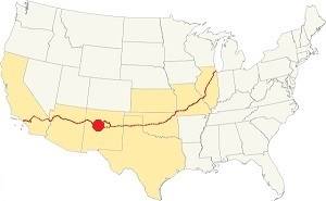
Location of Cubero on Route 66
The weather in Cubero is sunny, arid and with low relative humidity (dry). Summers are quite hot and winters are cold. Cubero has 278 sunny days per year.
Summer: the average high temperature (Jul) is 89°F (31.7°C) and the average summer low is 56.3°F (13.5°C). Winter: (Jan) the average high is 47.4°F (8.6°C) and the average low is 17°F (-8.3°C); below freezing point.
Average rainfall is 10.5 inches (292 mm) per year, and most (6 in. - 152 mm) falls during summer and early fall (Jul. to Oct.) during the "Monsoon" period. There are 53 rainy days per year. Expect on average 18 inches of snow per year, falling between November and March.
Tornado risk
The tornado risk in Cubero is nil: Cibola County has no Tornado watches. The area west of this point has no tornado events at all.
Tornado Risk: read more about Tornado Risk along Route66.
Map U.S. 66 in Cubero New Mexico
Maps of Route 66
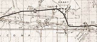
After leaving Paraje Route 66 followed the valley of San José River westwards on the north side of the river and railroad.
The original 1926 to 37 Route 66 continued straight into Cubero and then turned west as shown in this 1920s-37 map, in the map above it is shown by the dashed black-white line through Cubero.
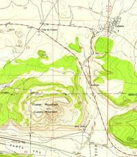
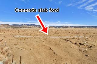
The western tip of the old alignment has been obliterated, but you can still see the original concrete slab ford on its western tip (pictured further down). We mark this gap in the highway with a green line
Cubero Cutoff
The 1937 highway bypassed Cubero along where NM-124 now runs, this is known as Cubero cutoff.
Route 66 Alignment near Cubero
With maps and full information of the old roadway.
- Lupton to Winslow (next)
- Albuquerque to Lupton (Cubero's)
- Santa Rosa to Albuquerque (previous)
The Santa Fe Loop (1926 - 1937)
Our Santa Fe Loop page describes the complete 1926 to 1937 alignment of Route 66 from Santa Rosa to Albuquerque through Pecos, Santa Fe and Bernalillo.
Getting to Cubero
To the west is Grants, Gallup (83 mi.) To the east is Laguna, with its Pueblo, Albuquerque (65 mi), and, along the Santa Fe loop of Route 66 are: Bernalillo, Santa Fe (124 mi.) and Pecos.
To the east, beyond Albuquerque are the towns of Moriarty and Santa Rosa.
Cubero: its Attractions
Landmarks, Route 66 sights
Historic Context
Jack Rittenhouse wrote 1946 Guidebook to U.S. Highway 66 when he drove along Route 66 from Chicago to Los Angeles. He mentions Budville's gas station at 57 miles from Albuquerque and the Cubero as follows:
Soon you come to CUBERO a small community off US 66 (R). Two roads enter the village from US 66, the western intersection being at 60 mi... There is a good cafe and tourist court at Villa de Cubero. Along the road here are gas stations, cafes, stores, a few cabins, but no other accommodations.
West of Cubero, the region appears more desolate. At 61 mi. is Los Cerritos Trading Post. Gas and grocery here. Rittenhouse (1946)
The Cubero NM Leg of your Route 66 Road Trip
You can drive from Budville west along the 1926-37 Route 66 Alignment, a 2.1 mi paved section of road (map). Nothing remains of the original stores and Route 66 spots on this alignment. After Cubero Loop was cut off in 1937 they moved. A good example is German born Sidney Solomon Gottlieb (1890-1963) who had married Agnes Effie Gunn in 1919. Sidney owned a trading post and was also a state senator. His store bought 250,000 lb of wool every year from the local community. His tradign post was the only spot with a phone and electricity. But when Cubero was bypassed he quickly relocated to a spot on the new alignment: Cubero Trading Post.
Our Lady of Light Church
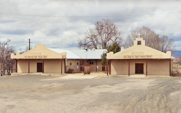
In the village, the main building is the Our Lady of Light church originally was built in 1866 with thick adobe walls to protect the residents from the Apache and Navajo raids. Visit the town during the Parish annual feast on January 1st. It includes an outdoor procession.
The original church was replaced by a new building between 1972 and 2011, pictured below:
Church of Our Lady of Light , Cubero, NM
You can head west along the old road -no stops along it, or return to Budville ant take the 1937 alignment westwards (map.
West along the 1937-70s Route 66
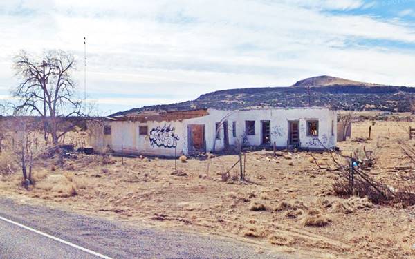
The highway leaves Budville and the fork of the old 1926 alignment into Cubero and curves around the north flank of Mount Cubero, to your left. Just 0.8 miles west is a former motel to your left. Sean Evans in his photograph of the place captioned it as "Old adobe motel, Cubero, NM. along Route 66. June 25, 2006." (1). It appears in the 1950s aerial photos of the area.
Head west, half a mile ahead is Gottlieb's complex comprising a trading Post, gas station, cafe, store, and cabins.
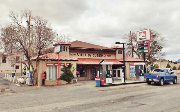
Villa de Cubero
This was the first motel west of Albuquerque and Gottlieb named the spot "Villa de Cubero" Spanish for "Cubero Village", like neighboring Budville, he created a new community borrowing the name of old Cubero but locating it on Route 66 he also built a family enterprise when he associated with his brother-in-law Wallace Harold Gunn (1908-1998) in the Villa de Cubero enterprise. Wallace ran the cabins and gas station while his wife, María de los Frutos Milán or "Mary" (1908-1996) ran the cafe. Mary was the sister of Salvador Milan, founder of the Village of Milan west of Grants NM, and Wallace helped Salvador build his "Milan Motel".
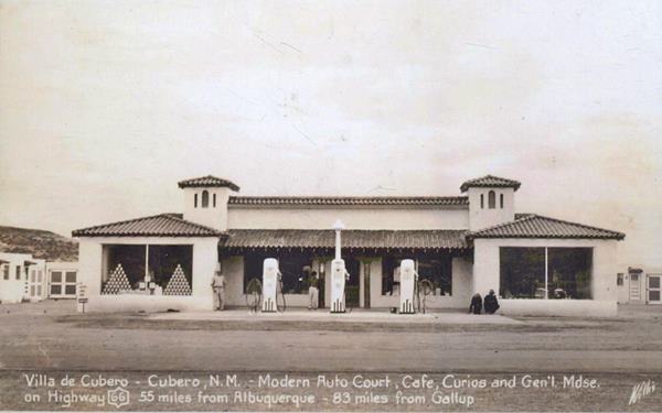
The postcard below proclaims "Villa de Cubero - Cuberon, N.M. - Modern Auto Court, Cafe, Curios and Gen'l Mdse on highway 66 55 miles from Albuquerque - 83 miles from Gallup."
The back of the card added: "'Gateway to Acoma' De Luxe Tourist Courts. Tile Showers and Every Modern Convenience. Restaurant in Connection... Phone Long Distance"
Ths Spanish revival style building with symmetric hipped corner stores topped with turrets, and a pent roof parapet covered in Spanish tiles linking them over a roofed verandah. Three gas pumps without a canopy and the cabins of the Auto Court around the courtyard behind it.
Cubero Cafe

Mary Gunn's Villa de Cubero Cafe c.1941. Source
Click to enlarge
Mary Gunn owned and ran the Café and diner, the "Home of Swell Eats!" It was here, that according to several researchers, Mary served meals to Ernest Hemingway in 1952.
The Legend of Ernest Hemingway in Cubero

Ernest Hemingway, 1957. Credits
American novelist, journalist and writer, Ernest Miller Hemingway (1899-1961), 1954 Nobel Prize in Literature and 1953 fictin Pulitzer Prize winner for "The Old Man and the Sea" is said to have written part of this novel in Cubero, here at the Villa de Cubero.
The official version is that it was written entirely in Cayo Blanco, Cuba in 1951 prior to its publication in 1952. However, there is a legend that he wrote it in Cubrero.
Journalist Susan Croce Kelly cites Wallace Gunn in 1988 as saying "We had Hemingway stay a couple of weeks with us while he was writing The Old Man and the Sea;" (2). This was repeated in other sources like Kathy Willingham in 1995 (3).
Johnnie Meier, a NM journalist interviewed Don Gunn (1937-2016) who was the fourth youngest son of Wally and Mary Milan Gunn. Don recalled Hemingway writing in the cafe and also being rude and misbehaving, tossing empty booze bottles out of the window of his cabin at the Villa de Cubero motel. He said his mother once warned her staff "Ahi viene el diablo puerco! ("There comes the dirty devil) when Hemingway entered the cafe. Hemingway, unbeknownst to Mary, understood Spanish very well. Don has a copy of The Old Man and the sea with the autograph inscription by Hemingway that reads "The Dirty Old Devil, EH". The book has a handwritten note on its cover page stating that it was "written at Villa de Cubero - Cubero NM in 1951. Hemingway stayed at Villa de Cubero 2 1⁄2 months accompanied by his wife and son" (4).
Evidence on Hemingway in New Mexico
Sandra Spanier, Edwin Erle Sparks Professor of English at Penn State University and General Editor, Hemingway Letters Project gives no credence the myth:
I've located no evidence that Hemingway ever made any extended visits to New Mexico or did any sustained writing there... However, he did visit New Mexico more than once, and his first visit was particularly significant. Sandra Spanier (5)
According to Spanier, in Dec. 1941 Hemingway and his third wife, Martha Gellhorn took their long delayed honeymoon (they'd married in Nov. 1940) which included "road trip" from Idaho across Utah, Arizona and New Mexico to Florida.
He repeated the journey with his fourth wife, Mary Welsh in 1946. In March 1959 he drove across New Mexico for the third and last time. (5)
Possible explanations
It wasn't the real author but a fake: someone impersonated Hemingway. Though it seems improbable that an impostor would exploit Hemingway's fame in a tourist court in New Mexico.
The facts are true but the dates somehow got jumbled in the recollections of the people who witnessed the events. Perhaps it wasn't in 1951, but in one of Hemingway's previous visits. Maybe it wasn't The Old Man and The Sea, but another novel. (6)
Other famous visitors
Wallace Gun recalled that there were many celebrities visiting the tourist court: Atom Bomb scientists like J. Robert Oppenheimer would take time off here from their research in Los Alamos, close to Santa Fe. Actors Dennis Morgan and Bruce Cabot shot some scenes here (with camels and elephants) while filming the 1943 musical movie "Desert Song". Vivian Vance (7) co-star in "I Love Lucy" and good friend of Lucille Ball, owned a ranch here and Lucille stopped at Villa de Cubero during her 1960 divorce from Desi Arnaz.
Ford across dry creek
Drive west along Route 66 for 04 miles, to your right, you will reach the western tip of the original 1926-37 Route 66 alignment, nothing remains of the old roadbed but you will see a concrete slab ford across a dry creek. The obliterated segment is highlighted with a green line in our custom map.
Mount Taylor Motel
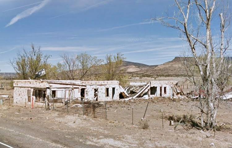
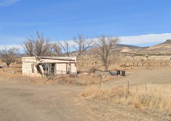
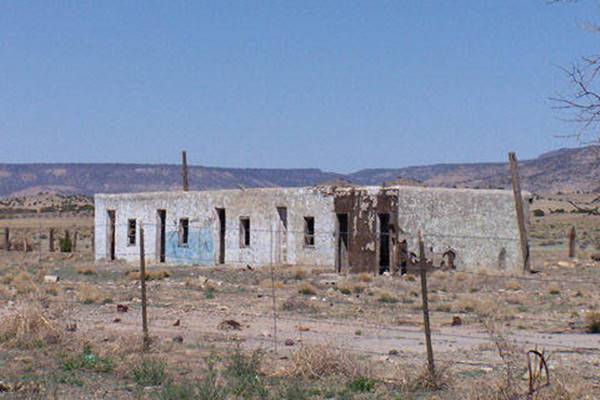
Just 0.2 miles west, to your right are the ruins of Mount Taylor Motel. They have been decaying for decades and soon the whole place will soon be gone. Below are two views (2014 and 2021). The Mt. Taylor Motel dates back to the mid 1940s early 1950s. It had a linear alignment perpendicular to the highway.
Another Cubero Motel ❌
Adjacent to the Mt. Taylor motel, to the west, on the right side of the higway is what formerly seemed to be a six unit motel. Adobe building opposite the Los Cerritos gas station.
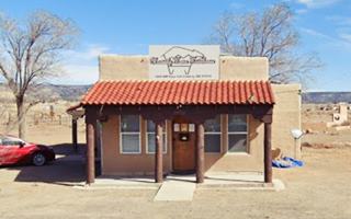
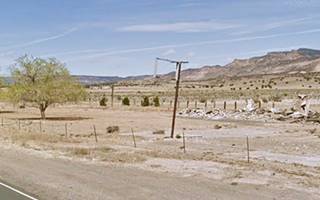
The building pictured below, in 2005, by Sean Evans has been torn down, and all that remains is the empty frame of its sign and the steel signpost facing Route 66 (see image). We haven't found any name or record about this motel. In 1946 Rittenhouse only mentions the gas, grocery and trading post across the highway.
Los Cerritos Trading Post
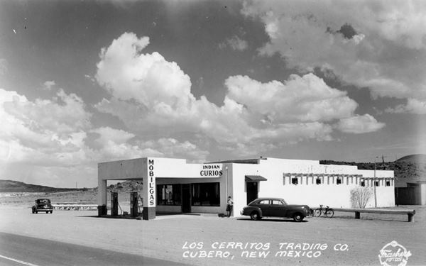
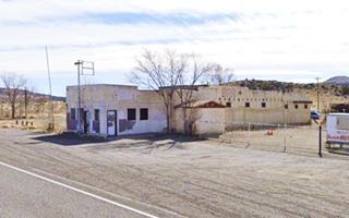
To your left, the long, single story building was formerly known as Los Cerritos ("small hills" in Spanish). The 1940s postcard below looks southeast at te Trading Post and Mobil station. Since then, the area under the canopy has been walled in and the building became a tavern, O.B. Hall's Lonbranch Saloon. Hall, known as Obie, had married Flossie, the widow of Bud Rice, owner of the Budville trading post ( murdered in 1967) after she became a widow for a second time in 1973 (after her second husband was also murdered!)
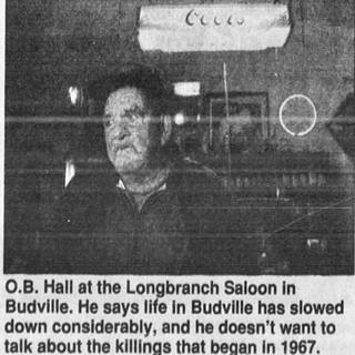
O.B. Hall in 1995. Source
North Acomita Village
Ahead to your left at the junction with Pueblo Rd. is an access to Acomita, the freeway, gas station, travel center, and a Hotel, Casino and Resort in North Acomita Village.
Elevation: 6,047 ft (1,843 m). Population 247 (2020)
The Atchison Topeka & Santa Fe Railway built a siding 6.4 miles west of Cubero Station, and named it after the Indian village that was south of it, on the south bank of the San Jose River: Acomita.
This small pueblo ("Acomita" in Spanish, is the diminutive of Acoma, so it means "Small Acoma"). It was the summer home of the Acoma people during the cultivation period in the fertile valley area.
Continue your Road Trip
This marks the endpoint of your trip through Cubero.Your Route 66 journey continues by heading west into the next village, San Fidel NM.
Sponsored Content

>> Book your Hotel in Albuquerque

Credits
Banner image: Hackberry General Store, Hackberry, Arizona by Perla Eichenblat
Jack DeVere Rittenhouse, (1946). A Guide Book to Highway 66.
Susan Croce Kelly (1988), Route 66: The Highway and its People


