Route 66 in Budville NM
Index to this page

TheRoute-66.com is reader-supported. When you buy through links on our site, we may earn an affiliate commission at no additional cost to you.
About Budville, New Mexico
Facts, Trivia and useful information
Elevation: 6,030 ft (1,838 m). Population: n⁄a (2020).
Time zone: Mountain (MST): UTC minus 7 hours. Summer (DST) MDT (UTC-6).
Budville is located in Cibola County, on Route 66 near Villa de Cubero.
History
For the ancient history of Budsville, visit our webpage Cubero's history.
Cubero railroad depot was located next to the village of Paraje, whose post office was named Casa Blanca (Spanish for White House). The original settlement of Cubero was six miles to the northwest of the depot.
When Route 66 was aligned along NM-6 in 1926 it went along the old road that linked Cubero with the railroad and the San Jose river communities. However a new alignment "Cubero cutoff" was built in 1937 that eliminated the longer course with a sharp 90° curve on it in Cubero for one that was shorter and had softer curves.
The Cubero businesses that catered to the travelers moved to the east and west junctions of the old and new alignments. Budville to the east and Villa de Cubero to the west.
Howard Neil "Bud" Rice (1913-1967) had opened his garage on Route 66 south of Cubero in 1936 (1). He ran it with his wife Aurora "Flossie" nee Chavez (1921-1994). They soon opened a Trading Company and named it "Budville". It grew into a Phillips 66 service station with a wrecker service and some cabins behind the building. There was a post office and they also sold Transcontinental bus tickets.
Bud Rice was persistent when it came to his business. When the planned I-40 bypassed his trading post in the late 1960s, he understood the consequences and lobbied to have an exit at Budville. He succeded and the exit is there, though the traffic seldom leaves the freeway to head towards the old trading post. And he was murdered shortly after.
The name: Budville
Named for H. N. "Bud" Rice. Bud is short for Buddy or brother and also the nickname for Robert, William, or Donald. We don't know where Huber Neil Rice got his nickname from.

Where to Stay: Hotels near Budville
There are no accommodation options in Budville, but neighboring Albuquerque has many lodging places for those driving along Route 66, you can book a hotel or motel in that town, or in Acoma Pueblo:
> > Book your Motel or Hotel nearby, in Acoma Pueblo or Albuquerque
More Lodging Near Budville along Route 66
Below you will find a list of some of the towns along Route 66 in New Mexico. Click on any of the links to find your hotel, motel or accommodation in these towns (listed from east to west);
On Route 66's Main alignment
The Santa Fe Route 66 segment
Eastwards
Westwards
>> There are RV campgrounds at Acomita
The weather in Budville
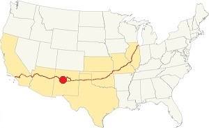
Location of Budville on Route 66
The weather in Budville is arid, sunny (278 sunny days per year) and dry. The arid climate causes cold winters and hot summers.
During winter (Jan) the average high is 47.4°F (8.6°C) and the average low is below freezing: 17°F (-8.3°C). The average high temperature in summer (Jul) is 89°F (31.7°C) and the average summer low is 56.3°F (13.5°C).
Rain falls during 53 days each year, adding up to 10.5 inches (292 mm). Most of it (6 in. - 152 mm) falls during the Summer Monsoon between July and October. Snowfall adds up to 18 inches each year and may fall between November and March.
Tornado risk
The tornado risk in Budville is nil: Cibola County has no Tornado watches. The area west of this point has no tornado events at all.
Tornado Risk: read more about Tornado Risk along Route66.
Map U.S. 66 in Budville New Mexico
Maps of Route 66
After leaving Paraje Route 66 followed the valley of San José River westwards on the north side of the river and railroad.
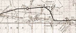
The original 1926 to 37 Route 66 continued straight into Cubero and then turned west as shown in this 1920s-37 map.
The western tip of the old alignment has been obliterated. We mark this gap in the highway with a green line
Cubero Cutoff
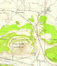
The 1937 highway bypassed Cubero along where NM-124 now runs, this is known as Cubero cutoff.
Route 66 Alignment near Budville
With maps and full information of the old roadway.
- Lupton to Winslow (next)
- Albuquerque to Lupton (Budville's)
- Santa Rosa to Albuquerque (previous)
The Santa Fe Loop (1926 - 1937)
Our Santa Fe Loop page describes the complete 1926 to 1937 alignment of Route 66 from Santa Rosa to Albuquerque through Pecos, Santa Fe and Bernalillo.
Budville: its Attractions
Landmarks, Route 66 sights
Jack Rittenhouse wrote 1946 Guidebook to U.S. Highway 66 when he drove along Route 66 from Chicago to Los Angeles. He mentions Budville without naming it, at the fork that leads to Cubero, after Paraje, as follows:
Soon you come to CUBERO a small community off US 66 (R). Two roads enter the village from US 66... There is a good cafe and tourist court at Villa de Cubero. Along the road here are gas stations, cafes, stores, a few cabins, but no other accommodations. Rittenhouse (1946)
The Budville NM Leg of your Route 66 Road Trip
We will describe it following Rittenhouse's course, heading west from Paraje. The highway curves to the northwest, following the valley of an intermittent stream that drains into the San Jose River, coming from the basaltic plateau that surrounds Mt. Taylor to the north. To the right is the cliffs that form the edge of Paraje Mesa that rise 300 ft. above the valley. To the left, beyond the freeway is Flower Mountain, also known as Cubero Mountain, with an elevation of 6,790 ft (790 ft. above the valley floor).
Abandoned Trading Post
After the church to your right is an abandoned Trading Post. The letters can still be seen, faded on the front of the store.
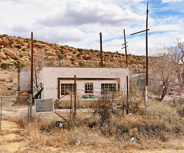
Ahead, to your right, in a field filled with rusty cars are some cabins strewn around. They make a nice photo:
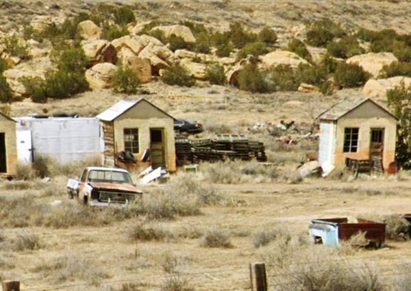
Budville Trading Post
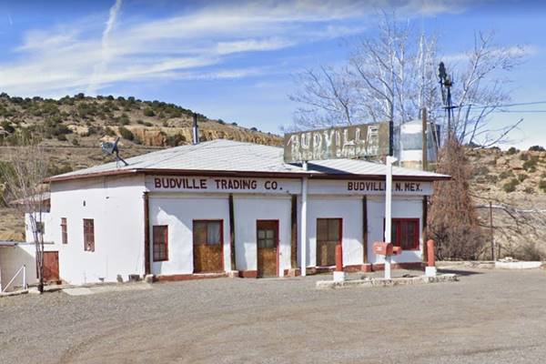
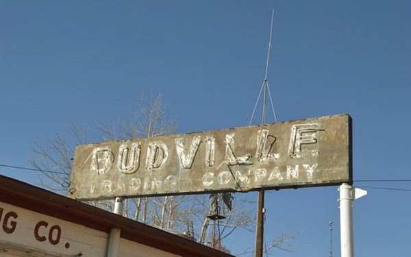
To your left is a hip roof building with an empty gas pump island the words "Budville Trading Co - Budville N. Mex" are painted on the facade, and a fading sign reads "Budville Trading Company". Below are two views of the building and the sign. This was the site of several violent deaths in the late 1960s and early 70s.
Neon sign of the Budville Trading Co.:
Murder in Budville
How Budville earned its nickname of Bloodville
Tow and wrecker service c.1960s

Bud Rice and his clerk Blanche Brown were both killed on the evening of Friday Nov. 18, 1967. The murderer stopped to fill up and while Rice was pumping gas he entered the store to buy cigarettes from Blanche Brown, an 82-year-old former school teacher. Thw stranger and Blanche got into an argument as Bud entered the store. The man pulled a 9 mm gun and pointed it at Bud. A struggle ensued and five shots were fired killing Bud and Blanche.
Aurora "Flossie" who was 46 years old at the time, was in the back of the store appeared and the man forced her to hand over the cash and jewelry, gagging her and tying her to a chair. Unknown to the murderer, there was another person in the store that night: Netie Buckley, who was the Rices' housekeeper. She had hidden in the bathroom when the trouble began.

Larry E. Bunten. Source
Nettie released Flossie who called the police and gave a description of the criminal. The cops set up roadblocks and captured a man. Flossie confirmed it was the right person. But, he wasn't.
The police had arrested 23-year-old Larry E. Bunten, a Navy first class petty officer. He was pulled over while traveling with his wife (an Acoma Indian) and their infant son. They had come to visit relatives. But ten days after his arrest, on Nov. 29, the FBI laboratory confirmed that Bunten's fingerprints didn't match those found at the crime scene. He was released.

Billy Ray White. Source
The case went cold until three criminals plea bargained and disclosed information about Billy Ray White, a 26-year-old criminal who they said was the criminal. He had bought a "set-up" on the Trading Post from someone in Albuquerque and gone there to steal the tens of thousands of dollars that Bud supposedly had stashed away in his store. White made it to the FBI's 10 Most Wanted list and he was spotted in Springfield Illinois on Aug. 17, 1968.
Flossie identified him as the criminal and White stood trial but was acquitted. He was extradited to Louisiana where he was facing charges for similar crimes committed in September 1967. He was found guilty and convicted to 10 years in prison. He died in jail on June 8, 1974 by apparent suicide and one of his fellow inmates reported that he had confessed he was the Budville murderer.
Nettie Buckley died in 1969 under mysterious circumstances and her sister believed that Flossie and her new 33-year-old husband Max feared she'd involve them in the murder so they denied her medical assistance, provoking her untimely death.
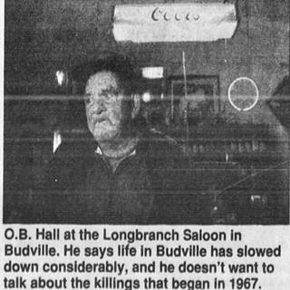
O.B. Hall in 1995. Source
Max Atkinson however, couldn't have been the Budville murderer because he was in a jail in Arizona at that time. Max died after a brawl, on June 7, 1973. His brother Phillip was killed in front of Budville Trading post in 1971 and Max was wounded in the same attack (2) (3)
Flossie, twice a widow, remarried for a third time, to Obie (or is it O.B.?) Hall, becoming Mrs. Aurora Hall, and continued running the store on her own until she closed it in 1979. I-40 bypassing Budville had brought on bad times. She passed away on April 10, 1994 and is buried at Budville Cemetery. (4)(5)(6)
The crime remains unsolved. Did Flossie and Max plot to murder Bud? Was Billy Ray White the murderer -after all he had committed similar crimes in the past?
We will close this story with some remarks by racing legend Bobby Unser, whose father ran a tow business and also owned a garage on Route 66 in Albuquerque (Jerry Unser garage) wrote in his 2004 book: "Not all the people who had garages on Highway 66 were as upstanding and helpful as my daddy. Bud Rice had a place on Highway 66 about 60 miles west of Albuquerque in Budville, New Mexico. He'd do things to break the cars... He was a bad person who gave auto repair a bad name. Someone eventually shot him and killed him. He reaped what he sowed." (7) (8)
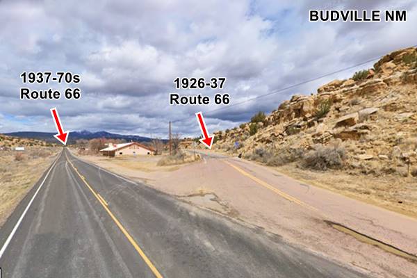
Just ahead, 100 yards west of the Budville Trading Co., the 1926 alignment forks to the right, towards Cubero. The later 1937 alignment, the "Cubero cutoff" heads straight. Below is the fork in the alignments.
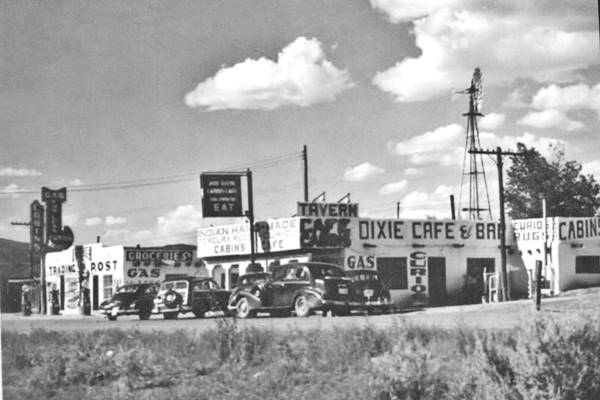
Dixie Bar
You can see Dixie Bar in the image above, to the right. According to its sign, it was established in 1936. Below is a 1940s photo. Notice it didn't have a gable roof at that time and that next door was a trading post with groceries, cabins, and gas pumps facing the higway. Both have vanished since then.
Dixie Cafe nowadays
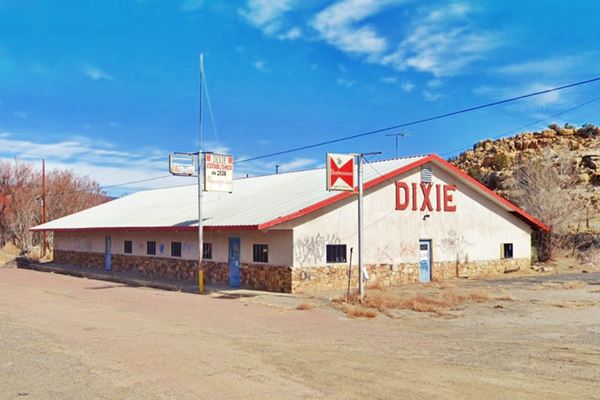
To your right, beyond the dry creek and Dixie is the old King's Café and Bar with its vintage signs from the 1950s. A memory of Budville and Route 66.
Continue your Road Trip
This marks the endpoint of your trip through Budville.Your Route 66 journey continues by heading west into the next village, Cubero NM.
Sponsored Content

>> Book your Hotel in Albuquerque

Credits
Banner image: Hackberry General Store, Hackberry, Arizona by Perla Eichenblat
Jack DeVere Rittenhouse, (1946). A Guide Book to Highway 66.


