Route 66 in Paraje NM
Index to this page
About Paraje, New Mexico
Facts, Trivia and useful information
Elevation: 5,948 ft (1,813 m). Population: 1,508 (2025).
Time zone: Mountain (MST): UTC minus 7 hours. Summer (DST) MDT (UTC-6).
Paraje is a village in Cibola County, on Route 66.
The archaeological site of Sandia Cave indicates that this part of New Mexico has been inhabited for over ten thousand years. In more recent times, the Native American Pueblo people have lived in the valleys of the rivers that flow from the Rocky Mountains into the Rio Grande Basin such as the San Jose River. They used the water to irrigate their crops of maize, squash and beans.
The first Europeans to visit this region were the Spanish of Francisco Vásquez de Coronado's expedition in 1540. They visited the nearby Acoma Pueblo. Later, when they finally annexed the area to their American Colonies in 1598, they subjected the Pueblo people by force and established missions to convert them to Catholicism. The Pueblo people expelled the Spaniards in 1680 (Pueblo Revolt), but they were reconquered in 1692.
In the 1880s the Atchison, Topeka and Santa Fe Railroad reached the area and extended its tracks from Albuquerque towards Gallup. They built a station at the small town of Paraje and named it Cubero although it was almost 8 miles from the village of Cubero. The site where Paraje was built had been in the past a pueblo of the San Felipe Indians who later migrated and moved to a place near Santo Domingo Pueblo, near Santa Fe.
The village was built in the 1870s within the land of the Laguna Pueblo when some refugees escaping from tribal factionalism left Laguna. To the south is Casa Blanca, a small community that forms part of the village.
The Name: Paraje
The Spanish word "Paraje" is defined as "the place where one stops to rest during a trip", the first part of the word comes from the Latin word "parare" meaning "to prepare", "to provide", while the suffix "-aje" in Spanish is the action associated to the verb "parar": a place to get ready for resting, a campground or stopping place.
It means a "Place", "Location". It is pronounced "Par-ah-he"
In 1926, Route 66 was aligned along the "Old National Trails" which linked Gallup, Grants and Paraje with Los Lunas and Albuquerque. It remained on the alignment and even today the old US 66 can be driven past the village.

Where to Stay: Hotels near Paraje
There are no accommodation options in Paraje, but neighboring Albuquerque has many lodging places for those driving along Route 66, you can book a hotel or motel in that town, or in Acoma Pueblo:
>> Book your Hotel in neighboring Albuquerque or Acoma Pueblo
More Lodging Near Paraje along Route 66
Below you will find a list of some of the towns along Route 66 in New Mexico. Click on any of the links to find your hotel, motel or accommodation in these towns (listed from east to west):
On Route 66's Main alignment
The Santa Fe Route 66 segment
Eastwards
Westwards
>> There are RV campgrounds at Acomita
The weather in Paraje
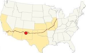
Location of Paraje on Route 66
The weather in Paraje is arid, sunny (278 sunny days per year) and dry. The arid climate causes cold winters and hot summers.
During winter (Jan) the average high is 47.4°F (8.6°C) and the average low is below freezing: 17°F (-8.3°C). The average high temperature in summer (Jul) is 89°F (31.7°C) and the average summer low is 56.3°F (13.5°C).
Rain falls during 53 days each year, adding up to 10.5 inches (292 mm). Most of it (6 in. - 152 mm) falls during the Summer Monsoon between July and October. Snowfall adds up to 18 inches each year and may fall between November and March.
Tornado risk
The tornado risk in Paraje is nil: Cibola County has no Tornado watches. The area west of this point has no tornado events at all.
Tornado Risk: read more about Tornado Risk along Route66.
Map U.S. 66 in Paraje New Mexico
Maps of Route 66
Read the Detailed Description of this segment (Albuquerque to Lupton). Below is the interactive map:
>> Custom map of Route 66 in Paraje.
The highway after leaving Laguna followed the valley of San José River with the railroad to the south of Route 66.
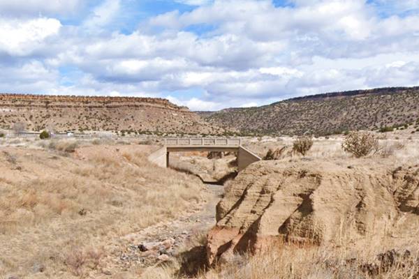
West of New Laguna, there is an old segment marked with a orange line in our custom map. There is a 1920s Bridge on it at the stream that runs beside Encinal Rd., a former early 1920s Route 66 alignment.
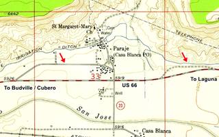
There are more remains of an older alignment near Paraje, the red arrows in the map mark them: the violet line in our map marks the eastern segment, part of which can be driven, and this is the map West of Paraje.
The later 1938 to 50s highway followed a straight course as shown in this map from Paraje to Budville - Cubero
Route 66 Alignment near Paraje
With maps and full information of the old roadway.
- Lupton to Winslow (next)
- Albuquerque to Lupton (Paraje's)
- Santa Rosa to Albuquerque (previous)
The Santa Fe Loop (1926 - 1937)
Our Santa Fe Loop page describes the complete 1926 to 1937 alignment of Route 66 from Santa Rosa to Albuquerque through Pecos, Santa Fe and Bernalillo.
Paraje: its Attractions
Landmarks, Route 66 sights
Jack Rittenhouse wrote 1946 Guidebook to U.S. Highway 66 when he drove along Route 66 from Chicago to Los Angeles. He mentions Paraje, three miles west of New Laguna as follows:
Paraje Trading Post. This single structure at the intersection of a road (L) to ACOMA PUEBLO. The direction to Acoma is plainly marked, and a visit to this remarkable place is a practically a "must." Rittenhouse (1946)
He then describes how to reach Acoma Pueblo and its history (more on this further down), and back on Route 66, two miles west of Paraje he mentionns a "Gas Station."
The Paraje - Acoma Leg of your Route 66 Road Trip
1920s Bridge on US66
We will drive westwards from Laguna along Route 66, passing by New Laguna on the way. Ahead, at Encinal Road, to your right, you will see a concrete bridge built across a dry stream, from the 1920s on the original Route 66 alignment here. See it in our custom map.
1920s U.S. 66 bridge near Paraje NM
Continue west. The cliffs run along the north side of the San Jose river valley, to your right. To your left, are the railroad tracks and beyond, the freeway.
Site of Paraje Trading Post
Ahead is the crossroads. To your right is Paraje's "downtown" area. To the left is the highway that leads to Acoma Pueblo. Here stood the Paraje Trading Post mentioned by Rittenhouse in 1946, on the NW corner of the intersection. It was survived until the late 1990s and was torn down.
The road to your right is the original alignment of US 66. It enters Paraje and turns west, meeting the later (current) alignment three quarters of a mile west of this point.
To the left it leads to Acoma Pueblo and visiting it is well worth it.
Acoma Pueblo
Day Trip to Acoma Pueblo
Mesa Encantada
Just before reaching Acoma Pueblo, on the left side of the road is the "Enchanted Mesa", which according to the Acoma myths was their original village named Katzimo. It is 350 ft. high (107 m) and is made of Zuni formation sandstone from the mid Jurassic Period around 180 Million years ago.
After Coronado reached the area in 1540, their ledgend says that a great storm washed the access ramps away stranding some old women on the butte while the rest of the residents were working in the fields below. They took this as an omen and moved to the nearby White Mesa, founding Acoma Village on it.
Acoma: The Oldest settlement in the USA
Settled in the twelfth century AD, Acoma Pueblo is believed to be the oldest continuously occupied settlement in the United States.
Taking a left, southwards from Old US 66 in Paraje it is 14 mi. to Acoma Pueblo along NM-23, south of the San Jose River. See this Map with directions from Paraje to Acoma Pueblo. It is, as Rittenhouse wrote in 1946, a "must."
Acoma, pronounced "Akk-uh-muh" (derived from their name "Haaku", which means "people of the white rock"), is one of the most remakable pueblos in New Mexico. It is built on the top of an isolated mesa named Acucuo, a flat-topped hill with sheer walls, 357 ft. high (109 m) that protected it from its enemies.
The hilltop dominated the surrounding areas until it was visited by the Spanish conquistador Francisco Vásquez de Coronado's expedition in 1540. The Acoma people were subdued by the Spaniards after a bloody three-day battle in 1599 when Oñate conquered New Mexico for the Spanish Crown.
Aerial View of Acoma Pueblo
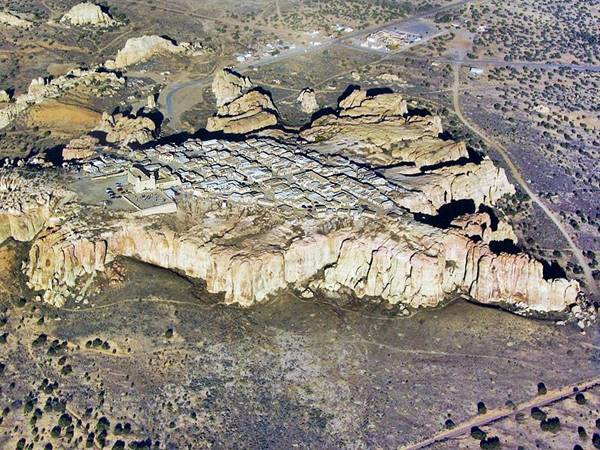
"Sky City"
Its location and the view you have from the hill gave it its name: "Sky City" (This Map shows where it is).
The Acoma people are expert in making thin-walled pottery. You can buy some at the Visitors Center at the base of the mesa (it also has a museum). More information at their website: ww3.skycity.com
The town's main festivities are: Feb., 1st. or 2nd weekend: Governor's Feast. Sept. 2, San Esteban Feast, Patron Saint. June: San Pedro, San Juan and Santa Ana in July (Corn Dance). There is a Crafts Fair during Thanksgiving, and a Luminaria Tour during the Christmas season (Dec. 24 - 28).
View of the buildings on the edge of the cliff, atop the mesa at Acoma Pueblo
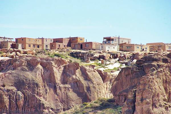
Important rules of etiquette during your visit to a Pueblo
Pueblos are on tribal lands and the local customs, religion, and traditions must be respected.
- Check that access is allowed (leaders may restrict access for private ceremonies) and be prepared to pay an access fee
- Photography. Taking photos may be totally prohibited or a permit may be required. Check with the Tribal Office. Even if you have a permit, always request permission before taking a photo of a tribal member. Leave your cell phone out of sight and silence it, as it could be confiscated
- Don't litter. Don't carry or use alcohol or drugs
- "Off Limits" signs must be respected. Don't remove artifacts or pottery shards
- Don't speed. Respect traffic signs
- Respect the local people. Dances are not a show, they are a ceremony. Show respect and remain silent at all ceremonies
- Cemeteries, Kivas, ceremonial rooms are sacred places and entry is not allowed for non-Pueblo people.
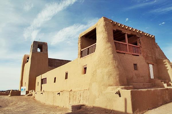
San Esteban Del Rey Mission Church
Pueblo, Acoma Pueblo, NM.
Listed in the National Register of Historic Places, US National Historic Landmark
The adobe church was built in 1629 a Spanish Colonial Mission church, in the Native American Pueblo
The church was built on the mesa inside Acoma Pueblo by the Spanish in 1629. It was dedicated as King St. Steven (San Esteban Rey) Mission church. Named after the Saint King of Hungary, Stephen I. The original adobe building still stands, despite the Pueblo Revolt (1680) that razed many Spanish colonial buildings. The tiny ancient cemetery is located beside the curch.
St. Stephen, San Esteban Rey mission church at Acoma Pueblo
The 1915 Guidebook of The Western United States published by U.S Geological Survey (1), describes it as follows:
"A short distance southwest of Laguna there comes in from the south a large valley, which heads in the vicinity of Acoma, one of the most remarkable Indian pueblos in the Southwest... this place is built on top of a high, isolated mesa with precipitous walls of gray sandstone and has been an object of great interest to travelers ever since the first visit of Coronado.
It is notable as the oldest continuously inhabited settlement in the United States. Unlike most of the other pueblo villages, Acoma is recorded in the early chronicles as the home of a people feared by the residents of the whole country around as robbers and warriors.
Its location upon a precipitous white rock (Akome, "people of the white rock") rendered it well-nigh impregnable to native enemies as well as to Spanish conquerors, for the only means of approaching it was by climbing up an easily guarded cleft in the rock. However, one of the Spanish expeditions, with 70 men, succeeded in killing 1,500 of these Indians—half their total number—in a three-day battle in 1599.
The entrance and stairway in use now are the same that were described by Alvarado on his visit with Coronado's expedition in 1540. The height of the mesa is 350 feet. The Acoma people are expert makers of pottery, as are also the Laguna Indians."
Back to Paraje and Route 66
Paraje Village
Return to Paraje and continue your journey. At the crossroads with Route 66, the 1926 alignment curved north and went through the village as shown in this map across Paraje. It was moved to its present course in 1932.
On the sloping hillside to the north is the village's pink church, St. Margaret Mary.
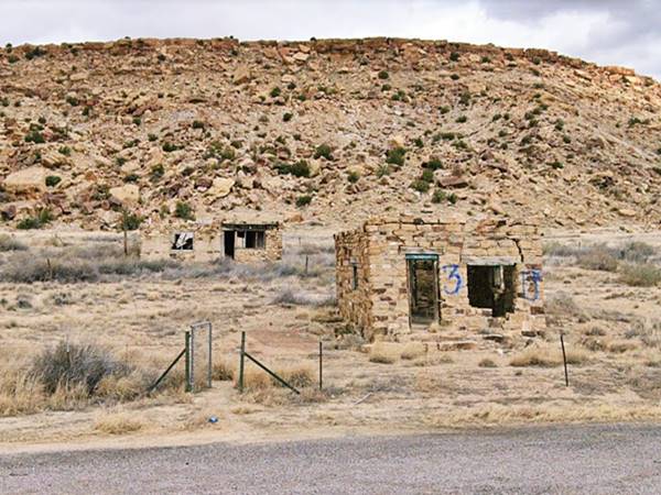
Abandoned Stone Gas station
Less than 2 miles west of the crossroads (map) to your right you will spot some vacant, abandoned stone buildings, they are part of what Rittenhouse described as a "Gas Station" two miles west of Paraje.
View of the Gas Station on US66 in Paraje
Marker The Battle of Khe Sanh Vietnam, 1968
Just one-half mile west, where the old highway curves to the NW as it approaches the Freeway to your left is a marker commemorating the The Battle of Khe Sanh Vietnam, 1968.
The inscreiption reads: "The Battle of Khe Sanh Vietnam, 1968 - "Home Was Where You Dug it" — Eternally Bonded — The Battle of Khe Sanh claimed the lives of 2,097 United States servicemen. This historic marker is dedicated to honor and preserve the memory of New Mexico Servicemen who were killed in action or later died of their wounds. The Khe Sanh Vietnam Veterans will forever live in each others' hearts." The other side lists the nine New Mexico Servicemen killed in action.
A View of Mount Taylor
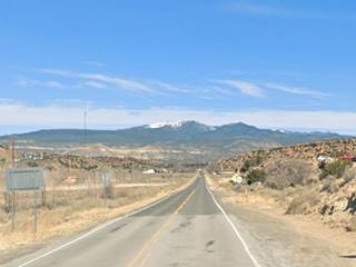
After the curve on NM-124 (2.5 mi. west of Paraje, just after the curve of NM-124), at I-40s Exit 104, look straight ahead, towards the north for a great view of Mount Taylor.
Mount Taylor was named after President Zachary Taylor. It is an extinct volcano towering upon a plateau of lava and sandstone in the Sierra San Mateo.
It formed 1.5 to 3.3 million years ago and its elevation is 11,301 ft (3.445 m) and is one of the Navajo sacred mountains.
It is a dormant stratovolcano (cone-shaped volcano).
It is within the Cibola National Forest Mount Taylor District.
Continue your Road Trip
This marks the endpoint of your trip through Paraje.
Your Route 66 journey continues by heading west into the next village, Budville NM.
Sponsored Content

>> Book your Hotel in Albuquerque

Credits
Banner image: Hackberry General Store, Hackberry, Arizona by Perla Eichenblat
Jack DeVere Rittenhouse, (1946). A Guide Book to Highway 66.


