Route 66 in Thoreau NM
Index to this page
About Thoreau, New Mexico
Facts, Trivia and useful information
Elevation: 7,200 ft (2.200 m). Population: 2,485 (2025).
Time zone: Mountain (MST): UTC minus 7 hours. Summer (DST) MDT (UTC-6).
Thoreau, which is pronounced as "Thuh-Roo" (like "threw"), is a town located on the first alignment of Route 66 in McKinley County, New Mexico.
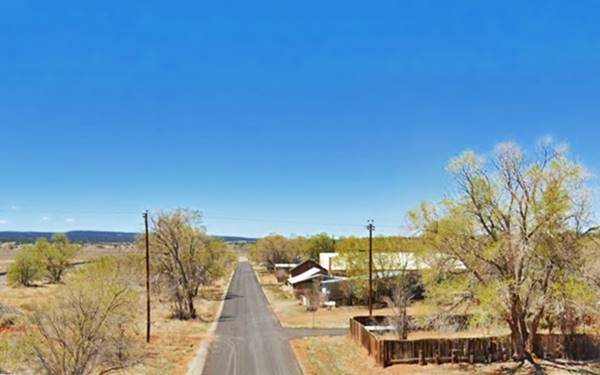
First Ave. in Thoreau, New Mexico, the 1926 to 1937 alignment of Route 66

Henry David Thoreau
Western New Mexico has been inhabited for over 10,000 years and the Native Americans who lived in this area during historic times were the Diné or Navajo.
The Europeans reached the area during the Francisco Vásquez de Coronado's expedition in 1540. The Spaniards explored the pueblos of Acoma and Zuni, just south of Thoreau. Almost sixty years later, they returned and settled the Rio Grande River area, subduing the local natives. Despite a brief period during which the natives revolted and expelled them (1680 - 1692), Spain held on to the territory until 1821, when it passed on to an independent Mexico. After the Mexican American War (1846-48), the territory became a part of the U.S.
During this period the region where modern Thoreau is located, had not been settled as the Navajo warriors kept European settlers at bay. Between 1862 and 1864 the American forces defeated the Navajo and opened up the area to settlement.
In 1881, the Atlantic and Pacific Railroad (later the Atchison Topeka and Santa Fe Railway) reached the area in and built a stop and siding which was named "Chaves" after a local family who had a small store there. By the way, there are still two sidings named Chaves just 4 miles to the east of Thoreau.
The post office was first named Chaves from 1886 to 1892, then it switched to Mitchell until 1896, finally becoming Thoreau after 1899.
The Name: Thoreau
Although Wikipedia and the locals maintain that Thoreau was a person who worked for either the railway, the Mitchells, or the army) and not the famous Henry David Thoreau, the book Thoreau, where the trails cross! by Roxanne Trout Heath (1982) affirms that it was named after the famous philosopher and has contemporary written proof to back her assertion.
Henry David Thoreau
Henry David Thoreau (1817 - 1862) was an American author, poet, philosopher, and naturalist. He was opposed to slavery and taxes, he was also a historian.
He is well known for his quotes; we list some below:
- Rather than love, than money, than fame, give me truth.
- Go confidently in the direction of your dreams. Live the life you have imagined.
- It is never too late to give up your prejudices.
- I would rather sit on a pumpkin and have it all to myself, than be crowded on a velvet cushion.
- Under a government which imprisons any unjustly, the true place for a just man is also a prison Henry D. Thoreau
The Mitchell brothers, William and Austin moved to the area in 1890. They had their eyes on the forests on Zuni Mountains where they wanted to build a sawmill and sell the lumber in the Southwest. They platted a town that they named "Mitchell". But their business did not prosper.
In 1896 Talbot and Fred Hyde Jr., heirs to the Babbit Soap fortune (Babbit was the first to sell soap in individually wrapped bars) sponsored a scientific expedition in New Mexico. The Hyde Exploring Expedition set up its base in Mitchell and from there conducted excavations in Chaco Canyon until 1901. Professor Frederick Ward Putnam of Harvard University and the American Museum of Natural History was in charge, and the field operations were directed by George H. Pepper. Accusations of impropriety ended the work but were later proved false.
The scientific expedition led to a growth in trading with the Navajo. When excavations finally ceased at Chaco, the Hyde brothers established a string of trading posts in the area and also renamed the town Thoreau. Perhaps because both Fred and Thoreau had graduated from Harvard (1)(2).
In 1900 Harabin Brothers, from Grants bought out A. Montoya & Co. and set up a General Store there. William Harabin was the postmaster in Thoreau in 1903 (3).
The Navajo name for the place was "Little Prairie Dog". (Dlóí Yázhí) because a Mexican with a large family lived underground in a basement, with no other structure above ground. When they left their home in the mornings, they reminded the Navajos of prairie dogs coming out of their burrows (4).
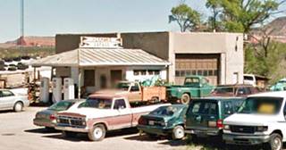
Herman's Garage, Thoreau. St. view. Click to enlarge
Route 66 was aligned right through the village in 1926, and followed a winding course that crisscrossed the tracks between Prewitt and Thoreau several times. It was straightened out in the mid 1930s and Thoreau was left on the north side of Route 66, beyond the tracks, just off its alignment. Drivers would have to go into the town, leaving US 66 to buy groceries of fill their tanks. The trading posts and garages moved to the new alignment. In the 1960s Interstate 40 bypassed the old Route 66.

Where to Stay: Find your Hotel in Thoreau
There are several lodging options on Route 66 in neighboring Grants (to the east) or Gallup (west) so you won't have difficulty to book your room:
> > Book your Hotel in neighboring: Grants or Gallup
More Lodging Near Thoreau along Route 66
Below you will find a list of some of the towns along Route 66 in New Mexico. Click on any of the links to find your hotel, motel or accommodation in these towns (listed from east to west):
On Route 66's Main alignment
The Santa Fe Route 66 segment
Eastwards
Westwards
>> There is an RV campground at Lake Bluewater and another in Grants
The weather in Thoreau
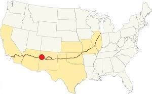
Location of Thoreau on Route 66
Thoreau has dry and sunny weather. The area is quite high and arid close to the continental divide. Summers are warm and Winters are cold; there is a large day-night temperature swing which makes for cool summer nights and very cold winter ones.
The average high in summer (July) is about 91°C (33°C), and the average low is 57°C (14°C). The average high in winter (Jan) is around 49°C (9°C), while the avg. low is only 15°C, well below freezing point (-9°C). Only 10.5 inches of rain falls each year (266 mm), most of it during the Summer Monsoon: July, August, September and October with 5.6 inches (143 mm).
Snowstorms do take place in winter and strong cold wind can be met during spring. Expect around 12 in. of snow during winter (30.5 cm).
Tornado risk
There is no tornado risk in Thoreau: McKinley County has no Tornado watches. The area west of this point all the way to California has no tornado events at all.
Tornado Risk: read more about Tornado Risk along Route66.
Map U.S. 66 in Thoreau New Mexico
Read the Detailed Description of this segment (Albuquerque to Lupton). Below is the interactive map:
>> Custom map of Route 66 in Thoreau
Maps of Route 66
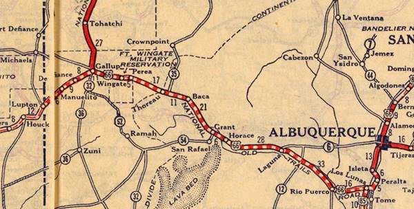
Historic segment of Route 66 from Grants to Thoreau
This segment of Route 66 is located in Cibola and McKinley counties NM between Grants and Thoreau.
Listed in the National Register of Historic Places
Route 66 in this part of New Mexico is listed in the National Register of Historic Places.
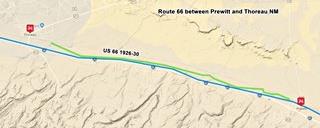
Pre-1930s Alignment Prewitt to Thoreau
The original 1926 US66 highway west of Prewitt ran along a course between the two A.T. & S.F. railroad track alignments, crossing both of them with grade crossings.
There is a faint alignment running parallel to the current one sandwiched between the two railroad grades that link both towns. There are many culverts and surviving bridge abutements along this segment. It cannot be driven along, but you could walk it or drive a bike along it. Notice that some culverts have washed away. It may lie in private property so request permission to avoid trespassing. The bridges are marked along the old alignment shown with a violet line in our custom map of missing Route 66 segments.
Through Thoreau and west (1926 -1937)
The road crossed the town along 1st Street and then 1st Ave for 1.2 miles as shown in the Map of Route 66 through Thoreau (1926-37).
The original alingment beyond there is now gone and ran just north of ther railway tracks as marked with a purple line in our missing segments map.
There is however one other place where it can be driven along, it is in Continental Divide, westwards from NM-27 for 1.5 miles till it veers off towards the north. (This map shows this segment).
After 1937, the current road
The road was paved in the mid 1930s when two level-crossings with the railway were eliminated by realinging the highway on the south side of the Atchison Topeka & Santa Fe railway. This hit the town of Thoreau, which remained on the wrong side of the tracks: Route 66 stopped passing along its Main Street.
Route 66 is now NM-122 and runs next to I-40 as its frontage Road from Milan all the way to the Continental Divide. The part in Milan was improved to a four-lane highway in 1951. In 1956, I-40 replaced Route 66. See a Map of this segment.
The historic segments continues all the way to the Continental Divide, west of Thoreau.
Route 66 Alignment near Thoreau
With maps and full information of the old roadway.
- Lupton to Winslow (next)
- Albuquerque to Lupton (Thoreau's)
- Santa Rosa to Albuquerque (previous)
Thoreau's Route 66 sights and Attractions
Landmarks, what to see in Thoreau
The town of Thoreau is set in a wide valley enclosed on the north by the red sandstone escarpments of the southern terminus of the Colorado Plateau, visible from Thoreau. Mount Taylor lies to the northeast and Powell Mountain to the northwest. To the south are the Zuni Mountains. The vegetation begins to change from the tumbleweed and shrubs commmon in the high desert, to one that includes pinyon pines and junipers.
Historic Context
Jack Rittenhouse in his 1946 Guidebook to U.S. Highway 66 described Thoreau as follows:
THOREAU... Thoreau Trading Post and Beautiful Mountain Trading Post here; gas and garage. Thoreau itself lies off US66 (R) Rittenhouse (1946)
This segment of your road trip begins in Prewitt. Drive along the north frontage road of the freeway, this follows the alignment of Route 66. At I-40s Exit 53, NM-371 crosses Route 66. At this crossroads is where the the buildings mentioned by Rittenhouse were located. The town itself is 0.3 miles to the right, on the north side of the railroad. An overpass crosses the tracks. And the first street is where Route 66 ran from 1926 to 1937.
Then it was realigned to its current roadway. The local residents wrote to the United States Senate Committee on Indian Affairs to request that the town site of Thoreau be purchased by the U.S. government and incorporated into the Navajo reservation due to the fact that "the highway has been moved away from the town..." among those signing the letter were businesses affected by the switch: J. L. Ambrose owner of the Red Arrow Cottage Camp, Crownpoint Trading Co.; H.C. Jones for Thoreau Mercantile Co., Laura Anderson of Anderson Garage, John J. Radosevich, Service Station Cafe, Evely Taylor of 66 Cafe (2).
Jones Mercantile Co. belonged to Homer Clay Jones; he owned the store and Navajo Indian Trading post located near Route 66 and the AT&SF Railroad. Navajo families would trade for supplies in the Jones store. He sold it to Dan Rangell in 1952 who renamed it Thoreau Mercantile.
Eventually those businesses catering to Route 66 travelers moved to the junction south of town. This aerial photo from 1958 shows all the buildings at the crossroads.
At the Crossroads: Route 66 landmarks
Beautiful Mountain Trading Post ❌
Located on the corner on the NE side of the junction. Dave Ortega owned it and ran it. The place burned down c.1950 so Dave moved his trading post business to neighboring Prewitt where he opened the Zuni Mountain Trading Post.
Red Arrow Trading Post ❌

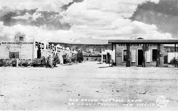
1932 Cottage Camp, Thoreau old US66. Source. Click to enlarge
Opposite Ortega's business, on the NW corner of the junction stood the Red Arrow Trading Post it was ran by Harry Boyd, known by the Navajo people as "Willa Chee" or "red ant" due to his rubicund skin. Like the Beautiful Mountain, the Red arrow also burned down (in 1960).
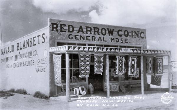
The pictures show the original complex that was located on First St. in downtown Thoreau on the old 1926-37 Route 66 alignment. These photographs were taken in 1932 shortly before the realignment of the highway. J. L. Ambrose owned this original trading post and cabins complex plus one in Chaco Canyon and two in Crownpoint.
Based on the views, the cottages were on the north side of first street (you can see the mesa of the Colorado Plateau in the distance). The Trading post was opposite, on the south side of the street.
Johnnie's Inn

c.1930 Johnnie's Cafe, Thoreau old US66. Source
John Radosevich, a Yugoslavian Croatian immigrant operated his Cafe on First Street and also signed the letter to the U.S. Senate in 1937. Had to move his business to the junction where he re-opened a cafe and bar. The black and white image depicts the original building on the 1926-37 Route 66 in downtown Thoreau.
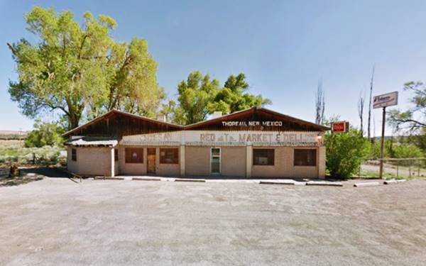
After his death in the 1960s his son Jay continued operating the bar. The building is still standing on the north side (right) of the frontage road next to the vacant lot where Red Arrow once stood it is the Red Mountain Market and Deli and Johnnie's Inn and bar. It is pictured below; we read on the Internet that the original Cafe building was moved here and is part of the structure (perhaps the bar on the left side of the building is the old cafe?)
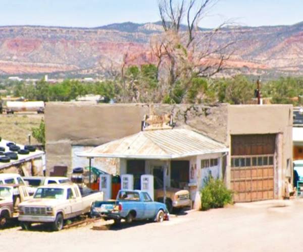
Ahead, to your right is the historic filling station and garage.
Roy T. Herman's Garage and Service Station
Also on Route 66 in Thoreau, NM, just west of Johnnie's Inn.

Herman's Garage in the 1980s. Thoreau US66. Source. Click to enlarge
Listed in the National Register of Historic Places
This is a classic service station built in 1937 on the realigned Route 66 in Thoreau. It is interesting to point out that this gas station has had three different locations! Prior to being in Thoreau, the steel building had originally been located in Grants (since 1935) as a Standard Oil Company station. When Route 66 was re-routed in Grants in 1937 (it ran along the south side of the tracks westwards and was moved to the north side at that time), the building was uprooted and placed on the new alignment just outside of Thoreau. At first it stood next to the Beautiful Mountain Trading Post on the eastern side of the crossroads, but in 1963 the building was moved to its current location, where until then had stood Griffin Morris' auto repair garage.
After World War II, the veteran Roy T. Herman operated it as a franchise.
Herman purchased it in 1950 and has operated it since then. After moving it in 1963, Herman stopped selling fuel and his business became a repair garage.
The building had enameled steel facade and a hipped canopy that covers the gas-pumps island with three vintage pumps.
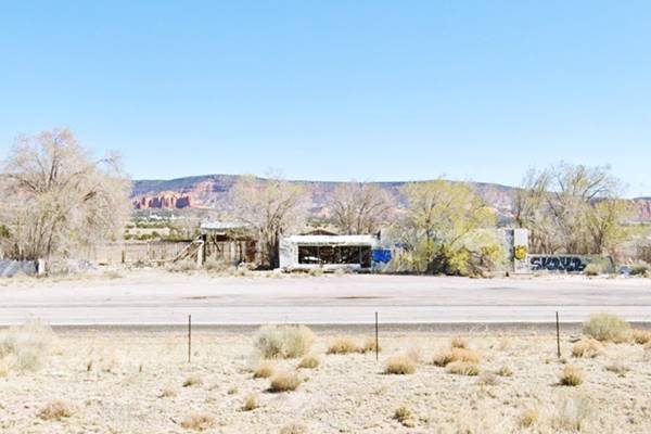
Continue west along Route 66 for 0.8 miles, and to your right is an abandoned building, a former trading post.
Thunderbird Bar and Trading Post
Built in 1947 by Bill and Charlie Bass, it started out as the Thunderbird Bar and Trading Post. It had a Texaco station and a grocery. They sold it in 1964 after I-40 bypassed. Later Max Sandoval housed his Indian Jewelry Manufacturing company here and there was a restaurant ran by Merly Rangel, his sister. The place is falling apart.
Continue your Road Trip
This abandoned trading post marks the endpoint of your journey in Thoreau head west into the next town: Continental Divide NM, to continue your Route 66 Road Trip.
Sponsored Content

>> Book your Hotel in Albuquerque

Credits
Banner image: Hackberry General Store, Hackberry, Arizona by Perla Eichenblat
Jack DeVere Rittenhouse, (1946). A Guide Book to Highway 66.


