Route 66 in Bluewater NM
Index to this page

TheRoute-66.com is reader-supported. When you buy through links on our site, we may earn an affiliate commission at no additional cost to you.
About Bluewater, New Mexico
Facts, Trivia and useful information
Elevation: 6,749 ft (2.057 m). Population: 464 (2020).
Time zone: Mountain (MST): UTC minus 7 hours. Summer (DST) MDT (UTC-6).
Bluewater Village is an unincorporated farming community in Cibola County New Mexico located close to Route 66 between Grants and Gallup.
Main Street, Bluewater, New Mexico
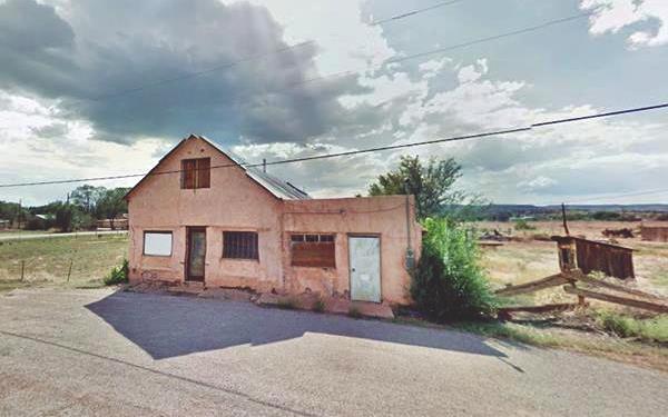
Human beings have been living in this area for over 10,000 years and the streams provided water for their survival in the high desert region. The historic Native Americans who lived in this area were farmers who built their villages or "pueblos" close to the rivers that flowed from the Rocky Mountains and used their water to irrigate their crops of squash and corn.
The expedition of Spanish "Conquistador" Francisco Vásquez de Coronado reached the nearby Zuni and Acoma pueblos in 1540. They were the first Europeans to visit the region. The Spaniards occupied what is now New Mexico in the early 1600s and despite the brief period (1680-1692) of the Pueblo Revolt, they subdued the natives and confined them in villages where they were converted to Christianism.
The area where Bluewater is located was under constant attack by the Navajo Indians. In 1821 after Mexico's independence from Spain, it became a part of that country. In 1848 it was ceded to the U.S. after after Mexico's defeat in the Mexican-American War.
The Name: Bluewater
According to the Indians, long before the lava flowed in the badlands (some 3,000 years ago) there was a lake in the valley. The Spanish explorers used the native name for the area and called it "Agua Azul" (Blue Water).
The town's name is due to the stream (Bluewater Creek) which also gives its name to the "Bluewater Valley.
In the 1850s, Martin Boure, a Frenchman made his homestead on the creek just above where the lake is now located. And in the early 1860s, the U.S. Army defeated the Navajo people and pacified the region. This increased the inflow of settlers and homesteaders. In the 1870s a cattle ranch was established there by another group of Frenchmen.
The Atlantic and Pacific Railroad, later Atchison Topeka & Santa Fe Railroad built a station nearby in 1881 and named it after the creek: Bluewater, a post office opened there in 1889. In 1885 the ranchers built an earthen dam on the creek, but the floods washed it away a year later. Finally, defeated by drought in 1892, the cattle men gave up.
At that time Ernst A. Tietjen who lived in nearby Ramah, claimed the land and built an earthen dam for irrigation at the point where the Cottonwood and Bluewater Creeks met. Soon other Mormon families settled there. The second dam was washed away again in 1904.
Tietjen was confirmed in the ownership of his homestead in 1905. He sold the first lot of Bluewater in 1910 to E. H. Dewey. the town was partly in his property and partly in the land of Thomas McNeil, the new village was named Mormontown, and was located to the west of the railway. The railway depot survived but the few inhabitants that lived next to it moved to Mormontown and changed its name to Bluewater.
The earth dam was replaced with a cement one which in turn was replaced by the current concrete arch dam constructed in 1926 - 27 by the Toltec-Bluewater Irrigation District. The water was used to irrigate the farms downstream towards Grants, which became at that time the "Carrot Capital of America". Later water was used for mining uranium. In 1926 Route 66 was aligned just north of the village linking it with Gallup and Grants.
When Valencia county was split in 1981, Bluewater became part of the newly created Cibola county.

Where to Stay: Find your Hotel in Bluewater
There are several lodging options on Route 66 in neighboring Grants so you won't have difficulty to book your room:
> > Book your Hotel in neighboring Grants
More Lodging Near Bluewater along Route 66
Below you will find a list of some of the towns along Route 66 in New Mexico. Click on any of the links to find your hotel, motel or accommodation in these towns (listed from east to west);
On Route 66's Main alignment
The Santa Fe Route 66 segment
Eastwards
Westwards
>> There is an RV campground at Lake Bluewater and another in Grants
The weather in Bluewater
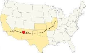
Location of Bluewater on Route 66
Bluewater has a sunny and dry climate. It is located in a relatively high and arid region between mountain ranges near to the continental divide. Winter is cold and summer hot. There is a large day-night temperature swing.
The average high in summer (July) is about 91°C (33°C), and the average low is 57°C (14°C). The average high in winter (Jan) is around 49°C (9°C), while the avg. low is only 15°C, well below freezing point (-9°C). A scant 10.,5 inches of rain falls each year (266 mm), most of it during July, August, September and October with 5.6 inches (143 mm).
Though some strong snowstorms may strike during winter, the average snowfall is around 11 inches (28 cm).
Tornado risk
There is no tornado risk in Bluewater: Cibola County has no Tornado watches. The area west of this point has no tornado events at all.
Tornado Risk: read more about Tornado Risk along Route66.
Map U.S. 66 in Bluewater New Mexico
Maps of Route 66
Since 1926 the highway followed the course of what is now NM-122 west of Milan through Bluewater and onwards to Prewitt.
West of Milan, the 1926 alignment of Route 66 was paved in the mid 1930s and remained unaltered until the mid 1950s when it was upgraded to a four-lane divided highway. At that time, a segment in Bluewater was straightened out and a portion of it was eliminated. We marked this section with a yellow line in our custom map. Part of this segment is overlaid by the freeway. By 1957, US 66 was a four lane alighment from Grants to Bluewater.
This four lane roadway was Route 66 from 1935 until the mid 1960s when the highway was realigned along the brand new I-40. . This is the US66 map from Grants to Prewitt, 18.7 mi along the N. Frontage Rd of the Interstate.
Route 66 Alignment near Bluewater
With maps and full information of the old roadway.
- Lupton to Winslow (next)
- Albuquerque to Lupton (Bluewater's)
- Santa Rosa to Albuquerque (previous)
Bluewater's Route 66 Attractions
Landmarks and sights: What to see, where to stop
Almost a Ghost Town
Historic Context
Jack Rittenhouse in his 1946 Guidebook to U.S. Highway 66 mentions this area as follows:
Several trading posts along here include Bowlin's, Pioneer and Brown's. Myrick garage here, too. Rittenhouse (1946)
We will drive through Bluewater heading west from Milan along the four lane Route 66.
Bluewater Motel and Inn

1950s advert of the Kings motels on US66, Grants, Milan and Bluewater. Source. Click to enlarge
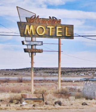
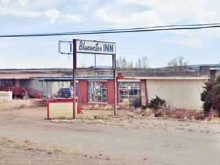
Drive west from Toltec on the western end of Milan, at the old D&A Court; after 3.5 mi. (map with directions) you will spot to your left the remains of a motel with its classic neon sign, and its restaurant: The Bluewater Motel and Inn.
Its postcard tells us that the motel had "22 New Ultra Modern Units (Completed May 1957) - with Air Conditioning - Wall-to-Wall Carpeting - Ceramic Tiled Baths (Tub & Shower Combinations). Telephone in Every Room - TV Rooms. Away from R.R. Noises - Complete Children's Playground." It also added that the local population of the Grants-Bluewater area had grown from 2,500 to 10,000 after Uranium was discovered here in 1952 and that the motel was directly across from the "famous Anaconda plant" that processed the uranium ore.
The motel was one of the three motels owned by Nestor E. King and his wife; the other two were the Franciscan Lodge ❌ in neighboring Grants and the Franciscan 2 in Milan.
Peggy and Cal "Toad" Cowell ran the Bluewater Inn for the Kings in the 1960s. The faded neon sign was made by Zeon Sign Company of Albuquerque in 1957. As you can see in the postcard below, it was a bright blue, now it is rusted and faded by the desert sunlight.
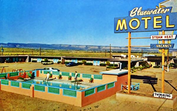
The Bluewater Inn is on the right side of the property, a restaurant from the 1960s, that served charcoal broiled steaks, seafoods and also cocktails.

Bluewater Inn advertisement 1950s. Source. Click to enlarge
Uranium's foul legacy in Bluewater
Uranium ore, with its characteristic yellow color was discovered by a local Navajo shepherd, Paddy Martinez in 1950. This led to a mining boom and bust cycle. The nearby former Bluewater Mill of Anaconda Copper, processed the uranium ore between 1954 and 1982. The site now off-limits, was reclaimed in 1995, under the provisions of the Uranium Mill Tailings Radiation Control Act, and is now monitored by the U.S. Department of Energy. The tailings impoundment site is just north of Route 66, here in Bluewater.
Allen's Garage
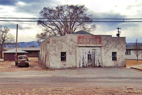
Continue west for 0.4 mi. and to your left you will spot an old garage. Allen John Payne opened his "Allen's Garage" on old U.S. Route 66 in January 1955 and you can see it in the 1956 aerial photograph of the area.
The highway continues running parallel to the railroad for 2.1 mi. When you reach the junction (Right) with Hwy. 605, you will see ahead, to your left, what is left of a classic Trading Post. It was located on the NW corner of Old Bluewater Rd. and Route 66. The Old Bluewater Rd. is now cut by the freeway that runs behind the post, but at one time it was one of the main links between Route 66 and Bluewater Valley.

Louise and Rusty Rapoport (and dog) in Bluewater 1950s. Source
Brock's Trading Post
To your left you will spot a Quonset hut; this was originally the second building that housed Brock's Trading Post. Quonsets were prefabricated buildings made with curved sheet metal walls typical of the post-WW II period.
The store's story is the following: Louise Rapaport née Brock (1923-2011) born in Connecticut and raised in Pasadena California moved to Bluewater in October 1947 and purchased the old Frontier Trading Post. It was the boom days of the post-WWII era and business was good. Louise's parents Otto and Mae moved out to Bluewater a few years later and became partners in the business. They renamed it Brock's Trading Post.
The original building was a long, single-story structure that comprised a café grocery store, curio shop, living quarters and a small Texaco gas station. The Greyhound bus stop was also located here.
Louise met Irving "Rusty" Rapaport, a young geologist working in Bluewater for the Atomic Energy Commission in the uranium mines. They married in 1952 and he started his own exploration business the following year. Bluewater and neighboring Grants experienced a boom, population increased, and the economy flourished.
In 1954 U.S. Highway 66 was upgraded to a four-lane divided highway and two additional lanes (eastbound) were added to it, the original Trading Post was torn down. That was when the Quonset hut was built.
Louise's parents moved back to Pasadena in 1955. But the change also affected Rapaport, things were different with the four-lane highway, some spell had been broken, so Louise sold her property, liquor license and business, and with Irving moved to Albuquerque to raise her family.
Brock's original trading post building
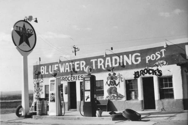
Brock's second trading post building (1954)
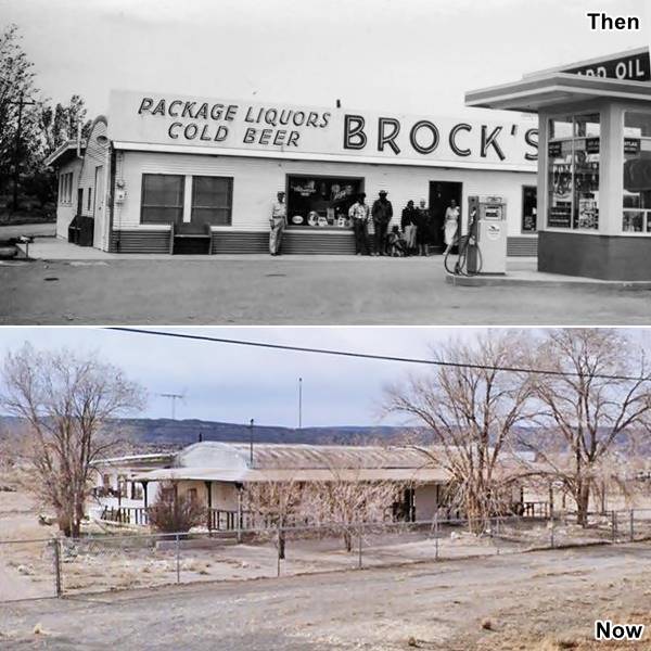
On the left side of both images you can see the softly curved Quonset Hut, and the same flat roofed building behind the hut.
Just 300 yards west there was a Cafe to the right and a building to the left of the highway. Both long gone.
Continue west to visit the Historic Bowlin's Old Crater Trading Post.
Bowlin's Old Crater Trading Post
To your left, at 7650 Old Route 66, Bluewater, NM.
Listed in the National Register of Historic Places
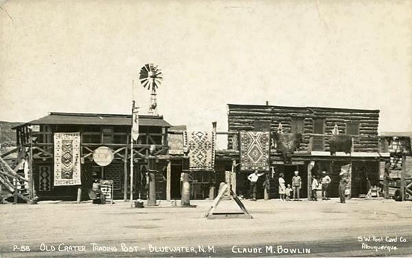
This is one of the few remaining examples of genuine trading posts in this area. It dates back to 1936 and its legacy continues until today.

Bowlin's Trading Post. St. view. Click to enlarge
It sold rugs, dolls, jewelry, and pottery. The murals depict the natives for the tourists in bright colors.
It was owned by Claude M. Bowlin who set up his first post on Route 66 here in 1936 and named it after a local volcanic crater. He had been trading with the Navajo since 1912 and after WW I, he opened several trading posts close to Gallup and later Farmington. Here he built a woodframe building and at first sold food and goods to local natives but as traffic grew along Route 66 in 1938 he added gas pumps and catered to the tourists too. He opened more stores dealing with native handicrafts in New Mexico in the 1950s, incorporated as a family owned and operated business that still exists as Bowlin Travel Centers -there is one here in Bluewater at the freeway's exit 72 (map). Business grew on Route 66 so the old store was demolished and a new one replaced it in 1954.
The new building had a flat roof and stucco walls with protruding viga beams and colorful murals.
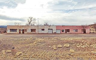
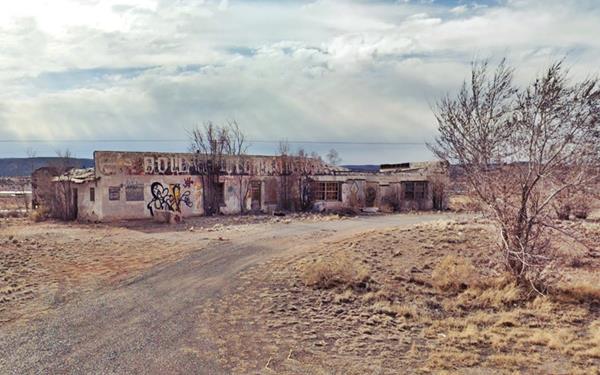
Claude Bowlin's daughter Hope and her husband Frank McClure assumed management of the new premises leasing it from the company. They lived at the property from 1956 to 1963 and changed the business' name to the "Thunderbird Trading Post." When they terminated the lease, it was managed by Michael Bowlin -Claude's youngest son- and his wife. They ran it until it closed for good in 1973. In the early 1970s I-40 bypassed the store, and traffic fell business dropped off. Claude died shortly after and his wife Willa sold the property in 1976; it was deeded for religious purposes only. It is now closed and abandoned (1).
Historic Bowlin's Trading Post nowadays: slowly decaying in the desert
Historic Bowlin's Trading Post nowadays: slowly decaying in the desert
Just ahead, the original 1926-56 Route 66 took a SE-NW course, now eliminated (but you can see it in the satellite views) or overlaid by the freeway. We marked this section with a yellow line in our custom map.
Rattle Snake Trading Post
Here is the Rattle Snake Trading Post that was built facing this "old" alignment as you can see in this 1952 aerial photograph. When the new alignment was completed in 1954 (the current roadbed) further east, the post simply moved is entrance around from front to back and continued catering to the travelers.
The story of this snake den starts with Leroy Atkinson and his wife Wilmerine who left their native Texas looking for work during the dark days of the Depression. Leroy found work at a trading post on Route 66 in Arizona and eventually set up his own trading post, the Box Canyon TP in Lupton by the state line in New Mexico. His success prompted his younger brothers, Jake and Herman to leave Texas and seek better luck in the tourist business in that same area. Jake learnt the trade and moved east to Bluewater to open his own trading post. He bought Victor Holmes' business and ran it with his wife Maxine. He also added a snake den to his store as he figured it would attract tourists, and it did. Herman imitated him when he moved to the next town on US 66 east of Bluewater (Milan) he opened the Cobra Gardens - Lost Canyon Trading Post.

Rattle Snake Trading Post 1950s. Source. Click to enlarge
Myrick Garage
Rittenhouse mentions a Myrick Garage in the area but we haven't been able to find where it was. However we did learn from the 1940 census data that Benton Myrick operated a garage and gas station here in Bluewater at that time and that he lived with his wife Virginia. His brother Henry Arthur Myrick owned a grocery store next to it and had married Birdie Beatrice Beason, who was Virginia's sister! So two brothers married two sisters and lived happily side by side on Route 66 (2).
Continue your Road Trip
This marks the endpoint of your journey across Bluewater; you can continue your Route 66 road trip by heading west into the next town, neighboring Prewitt NM.
National and State Parks
Outdoors and Nature in Bluewater

Bluewater Lake dam. Source
There are several parks in the are surrounding Bluewater with amazing outdoors: lava flows and sandstone cliffs we describe them and some tours in our El Malpais and Lava Badlands webpage.
Much closer to the village is the Bluewater Lake State Park:
Bluewater Lake State Park
See the Map with directions.
It is an artificial lake created by a dam in 1926-27 on the Bluewater Creek and located among the foothills of the Zuni Mountains with juniper and pinion trees dotting the slopes.
There is a campsite (with RV hookups available).
The lake is set at 7,555 ft. and is one mile wide and seven and a half miles long. A great spot for watching birds, fishing, or hiking.
More details at the Park's website.
Sponsored Content

>> Book your Hotel in Albuquerque

Credits
Banner image: Hackberry General Store, Hackberry, Arizona by Perla Eichenblat
Jack DeVere Rittenhouse, (1946). A Guide Book to Highway 66.


