
Route 66 in Milan NM
Index to this page
About Milan, New Mexico
Facts, Trivia and useful information
Elevation: 6,430 ft (1.959 m). Population: 2,455 (2025).
Time zone: Mountain (MST): UTC minus 7 hours. Summer (DST) MDT (UTC-6).
Milan is a town in Cibola County in western - central New Mexico that split from Grants to become an independent city in Cibola county.
History
For the early history of Milan, visit our Grants page. During its early days, Milan was a rural community based on sheep ranchs, it had been part of the vast empire of Silvestre Mirabal, inherited by his daughter Veneranda and her husband Salvador Milan.
A Story of Two Men

Salvador Milan c.1965. Source
Silvestre Mirabal (1864–1939) was a sheepherder, farmer, and politician who lived in San Rafael, a few miles south of what is now Milan. He was a hard working man who started out as a cowboy and built an empire. He was a trader and also acquired a vast holding of land in New Mexico. He was one of the state's richest men and a notable politician. He was inducted into the National Cowboy Hall of Fame in Oklahoma posthumously in the early 1960s.
Salvador Milan (1909-1979) was born in Mexico. His parents had migrated from Spain in 1898, but political unrest in Mexico prompted them to move with Salvador and his sister Mary to Gallup, NM in 1913.
Salvador worked at his father's grocery store, in coal mines, and picking cotton. Salvador met Veneranda Mirabal better known as Bennie (and much later as Grandma Bennie, and Aunt Bennie). She was born in San Rafael in 1910, and was one of Silvestre Mirabal's six children. Salvador and Bennie maried in 1931 and moved to Gallup where they both ran Salvador's People's Market.
Salvador's sister married Walter Gunn, who owned the Villa de Cubero trading post in Cubero.
Bennie was one of Mirabal's six heirs, and she received the ranch in what is now Milan. The couple moved there in 1941 and after a few years of sheep ranching, converted to a truck farm, and Grants became the Carrot Capital of the world in 1945. A year later Salvador built the Motel Milan with help from his brother-in-law Wallace Gunn, the first commercial building in what would become the Village of Milan.
Carrot Farming

Village of Milan seal. Source
Carrots were an important part of Milan's economy, and one appears in the village's seal.
The first settlers focused on logging and sheepherding but when the concrete Bluewater dam was built in 1926 by the Toltec-Bluewater Irrigation District water became plentiful and the Mormon ranch there showed that agriculture could be profitable in this area.
Card and Dean Stanley acquired 400 acres of land there in 1939 and their experimental farm showed that vegetable crops could grow in the fertile volcanic soil of the Rio San Jose Valley: peas, cauliflower, broccoli, cabbage, potatioes and of course carrots, which became the main cash crop. At its peak, 2,000 acres were producing carrots and the truck farmers were shipping them out by train: 2,000 boxcars each season.
Truckload of carrots c.1940s

But the crops eventually moved to well water as a constant source of water. Salvador was told that there were no viable drilling spots for a water well so he hired a water witch or dowser to find a good spot to sink a well. The man found a good spot, and the water table was at a shallow 80 feet below ground level. Some wells in the area were up to 600 feet deep.
Migrant worker, mainly Navajos, came for the planting season in April and the harvesting
There was a Commissary mentioned by Rittenhouse in his 1946 guidebook to Route 66 where they could buy on credit until they were paid at the end of the season. After settling their dues with the Commissary they took the rest of their cash back home.
In the late 1950s, celophane bags replaced leaf carrots, lower water tables brought on water scarcity, and the more efficient California farms were much cheaper. The carrot boom ended with a bust (1)(2).
A Town is Born
As the bust period approached, Salvador realized that subdividing the property and selling lots in a real estate project would make more economic sense than farming, so in 1956 he founded the Village of Milan, named after himself.
The Name: Milán
The surname Milan is quite frequent in Spain; and it has two origins, one which derive from "Millán" and originated from the latin family name "Aemilianus" meaning eager and laborious. The other origin comes from the Germanic name "Milan" from the Goth root "Mil-" meaning "generous, good."
In Spanish it has an accent on the "a", meaning that the last syllable is pronounce stronger (mee-lan).
On February 12, 1957, Salvador Milan and local entrepreneur Lee Hanosh who presented their request to Valencia county commissioners to incorporate the Village into a 720-acre tract. The peition was signed by 150 residents as required by Law. The petition asks that the Village be incorporated into a 720-acre tract. Salvador was elected as the first Mayor of the Village of Milan, and until his death in 1979, he had been its only mayor.
After the carrots bust, came the uranium mining boom that on and off fueled the local economy until it turned sour in the 1980s. Nowadays the privately operated Cibola County Correctional Center (it has over 1,000 federal prisoners) is the major employer.

Where to Stay: Find your Hotel in Milan
There are several lodging options on Route 66 in neighboring Grants so you won't have difficulty to book your room:
> > Book your Hotel in neighboring: Grants
More Lodging Near Milan along Route 66
Below you will find a list of some of the towns along Route 66 in New Mexico. Click on any of the links to find your hotel, motel or accommodation in these towns (listed from east to west):
On Route 66's Main alignment
The Santa Fe Route 66 segment
Eastwards
Westwards
>> There are RV campgrounds in Milan and Grants.
The weather in Milan

Location of Milan on Route 66
Milan is located in a dry and sunny region. It is quite high; an arid region nestled between mountain ranges close to the continental divide. Winters are cold and summers are hot. There is a large day-to-night temperature swing.
The average high in summer (July) is 91°C (33°C) and the average low is around 57°C (14°C). In winter, the average high (Jan) is 49°C (9°C), while the average low is only 15°C. This is well below freezing point (-9°C). Only 10.5 inches of rain fall each year (266 mm) and July, August, September and October have most rain (5.6 in - 143 mm).
Snowstorms may strike during winter and on average 11 in. of snow fall each winter (28 cm).
Tornado risk
There is virtually no tornado risk in Milan: Cibola County has no Tornado watches. The area west of this point has no tornado events at all.
Tornado Risk: read more about Tornado Risk along Route66.
Map U.S. 66 in Milan New Mexico
Read the Detailed Description of this segment (Albuquerque to Lupton). Below is the interactive map:
>> Custom map of Route 66 in Milan
Maps of Route 66
The original Route 66 from Grants to what is now Milan, from 1926 to the 1930s (1) left Grants along the south of the railroad along San Jose Drive, a winding road on the south side of the San Jose river that crossed the early Hispanic settlment of Alamitos. It turned south along Third St., with a grade crossing over the A.T. & S.F. tracks. The western tip of this segment is gone. See the pink line in our custom map from Grants to Milan.
Grants was the first major town west of Albuquerque and it has its share of Route 66 landmarks, with its neighbour Milan they were a uranium mining center from the 1950s to 1980s.
Grants to Prewitt
The original Route 66 in Grants 1926-30s (1) ran south of the railroad along San Jose Drive, a winding road on the south side of the San Jose river that crossed the early Hispanic settlment of Alamitos. It left Grants along Third St., with a grade crossing. The western tip of this segment is gone. See the pink line in our custom map.
Since the mid 1930s, the highway follows NM-122 from Grants through Bluewater and onwards to Prewitt, this was Route 66 from 1935 until the mid 1960s when the highway was aligned along the brand new I-40. By 1957, it was a four lane alighment from Grants to Bluewater. This is the US66 map from Grants to Prewitt, 18.7 mi along the N. Frontage Rd of the Interstate.
Route 66 Alignment near Milan
With maps and full information of the old roadway.
- Lupton to Winslow (next)
- Albuquerque to Lupton (Milan's)
- Santa Rosa to Albuquerque (previous)
Milan and its Attractions
Landmarks, Route 66 sights
Historic Context
Jack Rittenhouse in his classic "Guidebook to U.S. Highway 66" published in 1946 gave an interesting description of this area, with its lava flows, and neighboring Grants. He does not mention Milan because the town was incorporated eleven years later (1957). However, he mentions some landmarks along the highway, giving the mileage from Albuquerque:
81 mi. "Grants..."
87 mi. "Vidal's Trading Post. Gas and curios..."
90 mi. "Hardenburg Commissary" a center that offered temporary lodging to crop pickers...
Your Route 66 Road Trip leg through Milan
Heading west from Grants, the highway crosses the A.T. & S.F. railroad. Originally it was a grade crossing in the 1930s when the highway was realigned, a viaduct was built just south of it. A second bridge was added in 1955-56 to carry the eastbound lanes of the new 4-lane highway. Both bridges were replaced by a new viaduct in 1985.
Green Goose
Just ahead to your right at 316 U.S. Route 66, is the sign of a 1950s drive-thru, the Green Goose Drive-In. It was "the place where Pirates and Flatheads meet", the image below was taken in 1961, an advertisement in the Highscool's yearbook. Before being the Green Goose it was the Charcos. The building is gone but the whitewashed neon sign is still standing. The Flatheads were the flathead V-8 and the Pirates were the local highschool's basketball team. Below is a "Then and Now" set of pictures.


Jerry's Phillips 66
To your left, at 417 U.S. Route 66 was Jerry's Phillips station, it also offered fuel oil for home heating and a mechanic. Below is an advertisement from the 1966 phone directory and its current view.

1966 advertisement, Jerry's sixty-six-service, Milan Rte.66

1966 advertisement, Jerry's sixty-six-service, Milan Rte. 66. Click for St. view
Whiting Bros ❌
There was a Whiting Bros station (number 257) in Milan, it was on the left (south) side of the highway roughly 0.3 miles west of the overpass. Very probably located where the Allsup's Alon station is now located.
Trails Drive-In ❌
One block south of the former Whiting Bros, between East and North Streets and Uranium and Valencia Avenues was the Trails Drive-In. It opened in 1953. At that time it was part of J.C. West's theater emporium that also included the West theater that opened in 1959, the Sahara Drive In (1958), and the Lux theater (1950), all of them in neighboring Grants. Its neon sign was the work of the Albuquerque Zeon Sign Co. (1961) and it had a capacity for 300 cars. The buildings and sign have been torn down after it closed around 1984, but you can see its typical drive-in shape in this satellite view.
Title 1950s gas station Texaco?

Gas station in Milan NM. Click for St. view
There were many gas stations mentioned in the 1966 phone book with an address like "West U.S. Hwy 66 - I-40 Milan," at that time I-40 was aligned along the four-lane route 66 roadbed in Milan. The modern freeway that now circles the town on its southwest flank didn't exist at that time. These gas stations were: "Milan 66" service station, Milan; "Lee's Mobil" Service station, Milan and "Voigt's Texaco" Station, Milan. We have not been able to pinpoint their location. As you will see below we have managed to identify other filling stations.
This gas station at 515 U.S. 66 on the south side of the higway was restored in the early 2010s, and its long flat canopy that stood over to pump islands was removed together with the islands (their outline can be made out in the concrete parking area). The plate glass corner office and the two service bays are in very good condition. The stone veneer hints at it being a Texaco station from the 1960s-70s. See this 2009 street view when it still had the canopy and pump islands.
Cobra Gardens - Lost Canyon Trading Post
Across the highway from the old gas station, to your right where the Dollar General is now located, and to the west of it (506 U.S. Rte. 66) are the remains of a snake pit or snake farm.
The Cobra Gardens also known as Cactus Gardens opened in 1946. It was owned by Herman Atkinson and his wife Phyllis; at first they named it the "Lost Canyon Trading Post... 1 1⁄2 miles west of Grants, New Mexico."
Herman's elder brother Leroy had been the first of the family to move west from Texas to work in the trading post business, he owned several of them in Manuelito NM, including the Box Canyon TP there. Herman's other brother, Jake owned the Rattle Snake Trading Post in neighboring Bluewater.
Herman's main business was selling merchandise and they bought two snakes to attract customers, placing them in the "Den of Death." Seeing that the snakes brought more people than those buying curios, they decided to add more snakes and charge an admission fee.

Eventually they expanded the reptile house and had over 300 snakes of all kinds from anacondas to cobras, pythons and rattlesnakes. The complex had murals with palm trees and stepped parapets:

But the golden days wouldn't last forever. Herman saw the freeway coming and understood what it would mean to his business. By 1954 he'd sold the property snakes and all and focused on Indian crafts at their trading post in Scottsdale AZ. In 1975 Herman and Phyllis published a book "A Guide to Indian Jewelry, Baskets, Silver, Pottery, Rugs, Beadwork, Kachinas and Turquoise" (1)
The new owners, the Thigpens ran it as Cactus Gardens until both passed away. In 1972 the new owners Ron and Cindy Smith covered the old cactus murals with a false Far West fort woodwork and renamed it "Milan Silver and Gold", selling Navajo jewelry; pictured below.

Silver and Gold store, 1971 Milan NM. Source. Click to enlarge

Cactus Gardens "murals" nowadays Milan NM. St. view. Click to enlarge
The false front woodworks has been removed and the old murals depicting palm trees and cacti can still be seen on the part of the building that survived until now.
El Ranchero Cafe (Frontier Bar) neon sign
To your left, at 619 U.S. Route 66, is the Ranchero Cafe with a great 1950s neon sign. It is a drive-thru and dine-in Mexican cuisine restaurant.

It used to be the Frontier Bar and Restaurant in the late 1950s and 1960s. The black and white advertisement below from the early 1970s mentions Q.G and Dale Bright as its owners. The neon sign is the work of Zeon Sign Co. of Albuquerque who made three of them for Frontier, this one in 1958, one for Frontier Inn, in 1961, and another for the Bar in 1971. At one time, according to its matchcovers, it was owned by Joe and Jean Tavoada (2).

To your right, after the bridge at 610 U.S. Rte. 66 was the Atex Oil Co service station, there still is a vacant gas station on the property, from the 1980s.
Shamrock Truck Stop
Just ahead, to your right, at 632 U.S. Rte. 66 just before Milan St. junction, is a former Shamrock Truck stop.
Modified over the years, a parapet was added to the office, levelling the stepped office with the higher service bays on the left. The sign has also been removed. Pump islands survive on the driveway. Below is a "Then and Now" view from 1978 when it was managed by Tom Goodrich.

Shamrock Truck Stop, 1978 Milan NM. Source. Click to enlarge

Shamrock Truck Stop nowadays, US66 Milan NM. Click for St. view
Day and Nite
Next door after the Shamrock station, to your right is the Day and Nite market that was owned by Frank Sumner and A. H. Fidel in the 1950s -notice the vintage cars in the picture below.
It offered "Tourist Supplies", hardware, health and beauty aids as well as a Delicatessen; "A one-stop complete food market."
It is still a market, the neon sign is the only change as you can see in the current view further down.


Day & Nite Market nowadays, US66 Milan NM. Click for St. view
Field's Chevron nowadays, US66 Milan NM. Click for St. view
Fields' Chevron
Across the highway, on the SW corner of Milan St. and Route 66 at 701 U.S. Rte.66 is an old Chevron gas station that in the 1950s was William Fields' station. Two service bays, transoms above their doors, and surviving flat canopy and pump islands. It was repainted in 2016 during a temporary art exhibition by Jamison Chas Banks (3).
Dinner Bell ❌
The Dinner Bell Cafe with its Zeon Signs Co. neon signs made in 1964 and 1967 was torn down years ago. It was operated by Leroy and Vivian Vaughn in the early 1960s. It stood across the street from the Day and Nite, SE corner of Milan and Route 66.
The Milan Motel

Milan Motel 1950s advertisement US66 Milan NM. Source
On the same block, 300 feet west, at 707 U.S. Rte. 66 is the former Milan Motel. It was the first building in Milan, Salvador Milan built this 12 unit motel in 1946 in a "log cabin" style with the help of his brother-in-law, Wally Gunn, owner of the Villa de Cubero trading post, cafe and motel in Cubero.
It had an unusual semcircular layout around the central office. It had gas pumps by the office.
Salvador's wife, Grandma Bennie ran it and also was in charge of the cafeteria.
It survived through the Uranium bust of the 1960s the bypassing of Route 66 by I-40, and the Uranium boom during the 1970s. The motel closed in the 1980s. Ron Yates purchased it and opened the Kachina Country Trading Post on the premises. The old neon sign made by Zeon Sign Co. in 1963 is still standing; compare it with the one in the 1950s advertisement, they are identical.
It was restored with a National Park Service Route 66 Corridor Preservation Program grant.

Same view nowadays, the office has two stories:

Mobil Station
Across the highway, to your right and opposite the old motel at 706 U.S. Rte. 66. was Ross E. Green's Mobil oil distribution warehouse in Milan. Still standing, as Chavez auto. Below are its current view and a 1968 advertisement:

Old Mobil 1968 advertisement. Source. Click to enlarge

Old Mobil (Chavez Auto) nowadays, US66 Milan NM. Click for St. view
Next door, at 714 U.S. Rte. 66 was the Beeline Service Center ❌ in the 1966 phone book. Now its concrete foundations mark the spot (street view).
Self Service Station (Ed Ruscha)
American artist Edward Ruscha lived in Los Angeles and drove frequently along Route 66 (he was captivated by it) and snapped black and white photographs. In his first book "Twentysix Gasoline Stations" published in April 1963, he included a service station captioned: "Self Service, Milan, New Mexico."
The station is gone, but the site remains, on the SW corner of Airport Rd. and Route 66 at 805 U.S. Route 66.
 1962 picture of Self Service station on Route 66 in Milan NM")
Ruscha's Self Servie station, 1962 Milan NM. Source. Click to enlarge

Site of Ed. Ruscha's Self Service station nowadays, US66 Milan NM. Click for St. view
In Ruscha's image you can see the Haystack mountain in the distance (left) it is partially obstructed by a truck in the current view. These pumps were located in front of Sturges store.
Bay Station ❌
Head west, at the junction with Sand St., on the SE corner was Manuel Diaz's Bay Station. It opened in the late 1950s, and its neon sign made in 1959 and again in 1961 by Zeon Sign Co. flashed "SAVE - BAY OIL". This company was founded by Charles Ulrick Bay (1888-1955) and supplied oil to independent operators. But it was pushed out of business as it lacked a uniform brand architecture for its stations.
Lee Gutierrez Mobil
At 1101 U.S. Rte. 66, opposite the Bay station across Sand was a Mobil gas station, owned by Ross Green but leased by Lee Gutierrez. The building is still standing with its corner office and two service bays. See picture below. Next door was "Grandma's Cafe."

Former Mobil gas station nowadays, US66 Milan NM. Click for St. view

Former Deep Rock gas station nowadays, US66 Milan NM. Click for St. view

Bruce's Deep Rock, 1960s advertisement Milan NM
Bruce's Deep Rock station
To your left, just ahead at 1115 U.S. Rte. 66, is Bruce's Deep Rock service station. In its advertisement in the 1966 phone book (pictured) it says it was located "W Hwy 66 Milan." Its distinctive features are the butterfly wing style canopy. The office and service bays have been modified since the 1960s. Above are two "Then and Now" images.
Dairy Queen
Next to the Deep Rock was Milan's Dairy Queen at 1305 U.S. Rte. 66. It closed for good. The neon sign is still there without its colorful acrylic panels or DQ sign. It was the work of Zeon Sign Co., who made it back in 1963. At that time it was operated by a Mr. Hunsaker.
Same view nowadays, the office has two stories:

Drive west, when you reach Horizon Ave. you can take a short side trip to visit a modern diner with a retro-style. It is located 0.6 miles away on the south side of the freeway (Exit 79) at 1300 Motel Drive (map with directions). Wow Diner is a chrome and neon diner with a retro vintage style that recreates the 1950s and 60s.
Crossroads Motel - Franciscan 2

1950s advert of the Kings motels on US66, Grants, Milan and Bluewater. Source. Click to enlarge
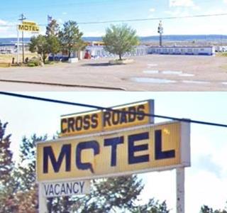
Crossroads Motel on US66, Milan. Click for St. view
Continue your trip westwards along Route 66 and 0.1 miles ahead is the final motel in Milan. To your left, this 15-room motel began as the "Franciscan 2" motel, part of the three motels owned by Mr. Nestor E. King and his wife; they also owned the Franciscan Lodge ❌ in neighboring Grants as well as the Bluewater Motel further west along Route 66.
Over the years it changed names at least twice, it was the "Stagecoach Inn" in the 1990s, and more recently it became the "Crossroads" motel.
The woodfaced building to the right, was the "Toltec", from the 1950s to 60s when Joe Dominguez owned it, it was known as "Joe's Bar".
End of Route 66 in Milan
This is the last Route 66 sight in the Village of Milan.
Toltec
Drive westwards from Milan along old for 2 miles and you will reach the tiny community of Toltec.
It consists of a scattering of houses that grew next to a railway station ca.1910 on the A.T. & SF railroad.
The name: Toltec
The Toltec culture was centered in the town of Tula, Mexico, around 800 to 1000 A.D. The Aztecs recognized them as their cultural predecessors (like the Romans did to the Greek). Their word "Toltecah" means "artisans". There has been plenty of discussion about a possible link between New Mexico Natives and the Toltec people.
Rittenhouse did not mention it in 1946, so it probably grew after that date.
D & A Court motel
The "Casa San Jose" at 2595 W. Route 66 (Hwy. 122) has an L-shaped building on the the eastern side of the propery; this is a layout typical of a motel. It is a single story, gable roof structure with an unusual sign for a child day care facility. We believe it may be the D & A Court neon sign made in 1959 by Zeon Sign Co. for a motel in Milan. The shape of the sign is clearly that of a 1950s one.
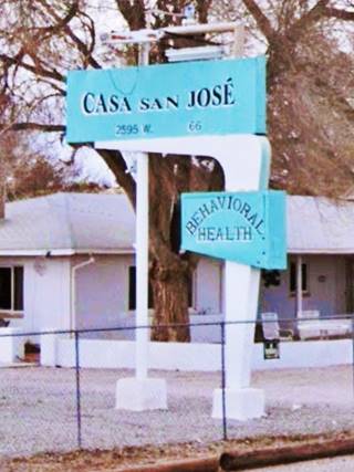
D&A Motel (?) neon sign nowadays, Toltec. Click for St. view

D&A Motel (?) on US66, Toltec. Click for St. view
Continue your Road Trip
This old motel in Toltec marks the endpoint of your journey through Milan. Continue your Route 66 road trip by heading west into the next town, neighboring Bluewater NM.
Sponsored Content

>> Book your Hotel in Albuquerque
Credits
Banner image: Hackberry General Store, Hackberry, Arizona by Perla Eichenblat
Paul Milan, 2013. History: The Way We Were - The Milan Motel.
Jack DeVere Rittenhouse, (1946). A Guide Book to Highway 66.