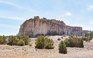
Top Natural attractions in Grants NM
Index to this page
Where to Stay: Find your Hotel in Grants
There are several lodging options on Route 66 in Grants itself, you won't have difficulty to book your room:
> > Book your Hotel in Grants or Gallup
More Lodging Near Grants along Route 66
Below you will find a list of some of the towns along Route 66 in New Mexico. Click on any of the links to find your hotel, motel or accommodation in these towns (listed from east to west):
On Route 66's Main alignment
The Santa Fe Route 66 segment
Eastwards
Westwards
>> There are RV campgrounds in Grants.
Day Tour to Zuni Pueblo via El Morro and San Rafael
A full 176 mile-long circuit. See the Itinerary Map. Outdoors and American History.
Zuni - El Morro Tour Summary
Head south from Grants towards San Rafael and visit the The Old Fort Wingate. You can extend your trip to the south, along NM-53 passing along the western side of the "badlands" of the El Malpais National Conservation Area, and visit El Morro National Monument and Zuni Pueblo, ending up in Gallup or returning via I-40 to Grants.
The Day tour described below, between Grants and Gallup via Zuni Pueblo is part of the Trails of the Ancients Byway, one of the designated New Mexico Scenic Byways. For more information on this Scenic Byway, Click here
Route 66 Historic Context
Jack Rittenhouse in his 1946 Guidebook to U.S. Highway 66 mentions the badlands as follows:
This lava flow is often called 'The Malpais," which means 'evil country.' In its tortuous area lie deserted pueblos, rumored hidden treasures, caves of perpetual ice, veins of ore, and the hideouts of early bandits. Its exploration is a hardy project, but many of the adventurous attempt it.
Many tourists come to Grants as their 'jumping off place' for side trips to the PERPETUAL ICE CAVES and EL MORRO NATIONAL MONUMENT, which lie to the southwest. Rittenhouse (1946)
The Itinerary
Head west from downtown Grants and take a left southbound along NM-122, crossing I-40 at Exit 81B. South of the Interstate, the highway becomes NM-53 and head south towards the town of San Rafael. At the entrance to the small town is the site of Old Fort Wingate:
Site of the First Fort Wingate
Historic Marker
It is 4.3 mi. south of Grants, on the eastern side of NM-53 at the junction with Old Highway 53 at San Rafael. See this Map marking the spot.
Inscription on the Historic Marker: "San Rafael, formerly know as El Gallo, is located at a spring near the Malpais, the great lave flow to the east. The area was visited by members of Vasquez de Coronado's expedition in 1540. In 1862, it was selected as the original site of Fort Wingate, focus of the campaign against the Navajos."
First Fort Wingate (1862 - 1864)

General James Carleton. Source
During the American Civil War, the Navajo Indians grew bolder and increased their raids on New Mexico. The new Military Commander, Gen. Carleton (1814-1873) decided to stop them.
He built a fort which was commissioned on Oct. 22, 1862 near what is now San Rafael, next to the Ojo de Gallo spring (Spanish words meaning "Cock spring"). He named it Fort Wingate.
Cap. Benjamin A. Wingate was an infantry officer who died during the Battle of Val Verde, fought on a ford on the Rio Grande on February 20 and 21, 1862 in Val Verde NM. An invading Confederate force defeated the Union troops that were controlling New Mexico yet soon after their victory, retreated back to Texas.
From the fort Carleton began the Navajo campaign against the Navajo and defeated them using scorched earth tactics. He then relocated them to "concentration" camps during the infamous "Navajo Roundup", making them trek 350 miles in what is know known as the "Long Walk" to Rio Pecos during which hundreds died of exposure. At their destination they were incarcerated with the already captive Mescalero Apaches and many starved because the land assigned to them wasn't adequate to feed them.
The plight of the Navajos attracted national attention, a Special Committe involving members of both houses of Congress investigated the dire conditions at Rio Pecos. The site was visited by the committee. The government acted on their recommendations: civil oversight of Indian affairs, and removal of Gen. Carleton who was relieved from his duties due to these atrocities and the Indians were allowed to return to their homes in the west.
The fort at Wingate became useless, it was to far from the homeland of the Navajo, so the new Commander, Gen. Getty decided to move Fort Wingate to a more western location and chose a site at Bear Springs near Grants, where Fort Lyon (also known as old Fort Fauntleroy) was located. Lyon was renamed "Fort Wingate" (More on Wingate here). The "old" fort was abandoned.
San Rafael

San Rafael Church, vintage postcard. Source
Elev. 6,470 feet (1.970 m). Pop (2020): 1,164.
The small community was originally located here because of a spring, ("ojo" in Spanish means in this case "water eye" or "spring"), called "El Gallo" ("The Cock"), perhaps due to the ducks, turkeys and grouse in the wetland next to it. In the past water was abundant and flowed east towards the Rio San Jose River. Later, excessive use lowered the water table and diminished the flow. In the 1880s it became known as San Rafael (St. Raphael).
During Coronado's 1540 expedition to New Mexico he sent a group of men to explore the area, and they visited San Rafael en route to Acoma Pueblo.
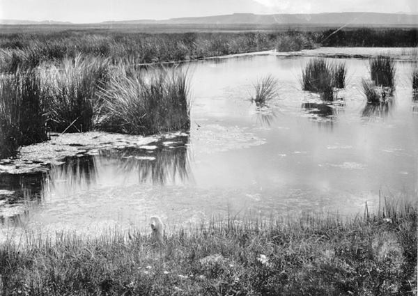
The Navajo name for the site is "Tó sido" where : "tó" is "water" and "sido" is "it is hot", meaning "Hot water" or "hot springs". The spring had a flow of 5 to 7 cubic feet per second until it dried up in the late 1940s and early 50s, perhaps due to a drought and exessive use for mining purposes. The flow ceased and the spring is dry. Tectonic processes may have played a role too.
Camel Stopping point
An expedition led by Lt. Edward Fitzgerald "Ned" Beale (1822 - 1893) was sent by the U.S. government to survey and build a wagon road from New Mexico to the Colorado River near present Needles CA and Tropock AZ. Beale camped at Ojo del Gallo in 1857.
He used camels, imported from Tunis as pack animals, the U.S. Army was keen on trying them out in the arid Southwest, but the project failed; though hardier than mules, the camels scared both horses and mules. The Army decided not to use camels in the future.
Around the Zuni Mountains
To your right you will see the Zuni Mountains which the road will follow along its eastern flank for 11 mi. To the left, beyond the low trees that cover the landscape, are the "badlands" or "Malpais" a jumbled lava flow area, that can be accessed via NM-117 hiwghway. We describe it further down in the El Malpais National Monument and National Conservation Area section.
Zuni Mountains
The Zuni Mountains are the remains of an eroded mountain range that towered to a height of 20,000 feet (6.000 m). All of the Triassic and Cretacic sediments have eroded exposing the core of ancient granite and metamorpich rocks, an anticline: an upward folded, convex area of sediments that were copressed 2 billion years ago during the Precambrian.
The area was folded during the Laramide mountain-forming orogeny 80 to 40 million years ago.
It is a high desert country area with lava flows and sandstone.
Cibola National Forest
The Cibola National Forest and National Grasslands spans several locations covering 1.6 million acres in New Mexico, Texas, and Oklahoma.
The area closest to Route 66 in Grants is the Mount Taylor District. There are two mountain ranges within the Mt. Taylor Ranger District: to the north Mt. Taylor and to the south, the Zuni Mountains. They cover 520,000 acres of land.
More information: Mt Taylor Ranger District, 1800 Lobo Canyon Rd.; Grants, NM. (505) 2878833. Official Website.

USGS map El Malpais Nat. Mon. Source
Click to enlarge
Western part of El Malpais Nat. Mon.
The Cibola National Forest flanks highway NM-53 to the north after the highway reaches the southen part of the range and curves westwards (right). To the south is the El Malpais National Monument as you can see in the map.
Volcanos
You will reach the El Malpais NPS Information Center (28 mi south of I-40). To the south of it there are several volcanic craters: Lava Crater, Twin Craters, Lost Woman Crater and El Calderon.
There is a chain of volcanoes along the Jemez lineament, an 800-mile-long "scar" that runs across NM with a SW to NE course. It dates back 1.7 Billion years and is a weak area in the crust and the mantle beneath it feeds volcanic activity. Some volcanoes are quite recent such as those in the Zuni–Bandera volcanic field that have lava flows and at least eight eruptive events that have taken place in the past 50,000 years.
The youngest is roughly 3,800 years old and is the McCartys flow.
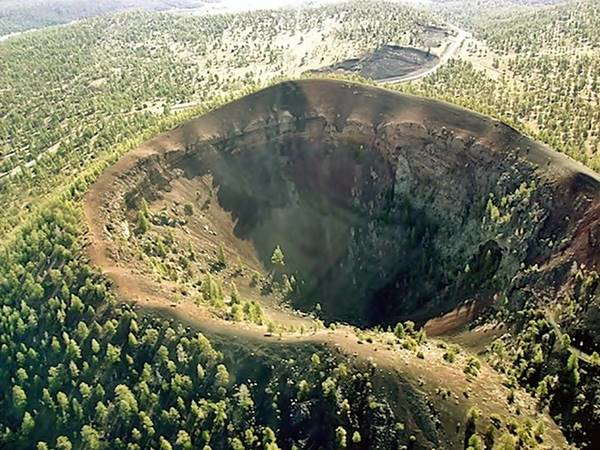
Bandera Crater and Ice Cave
Ahead, to your left is the privately operated atttraction, the Bandera Crater and Ice Cave.
Bandera Volcano
This is a 10,000-year-old volcano with a crater 1,400 feet wide and 800 ft. deep (427 m by 244 m). Bandera means "flag" in Spanish. It is located on the land of the Mirabal and Candelaria family.
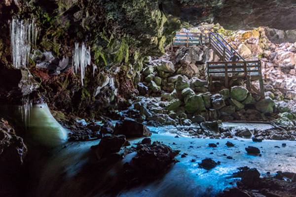
The Ice Cave
There are many kinds of ice caves in El Malpai: stalctite and stalagmite, crystalline, and frozen floor caves. They are the southernmost ice caves in North America. They form when the cold winter air, denser than warm air, flows down into the underground tunnels and lava tubes of extinct volcanos. This air is below freezing point (32°F - 0°C) and any water that enters the cave through seepage or rainfall, freezes.
The Bandera Ice Cave is within a collapsed lava tube and the floor of the cavern has a layer of ice 18 ft. (6 m) thick.
It was known to the Pueblo Indians as the Winter Lake and ice was mined until 1946 and used by the Navajo and also by white settlers to cool food.
One-quarter mile west of the entrance road to Bandera Crater the road crosses the Continental Divide, the great watershed from which the waters flow west towards the Pacific Ocean or east towards the Atlantic Ocean. Route 66 crosses it too, further north (read all about it in our Continental Divide webpage).
El Morro National Monument
Continue west for 15 miles, the road reaches the El Morro National Monument (43 mi.) You can visit its Official Website for more details.
Its Inscription Rock, accessible along an easy trail has over 2,000 inscriptions carved in the sandstone.
The name "El Morro" is Spanish and means "The Bluff", "The Headland". It is a great sandstone promontory which provides a shaded oasis for those traveling along the trails south of the Zuni Mountains. It was a good camping spot and many explorers who passed by left their names, dates, or simply inscribed their symbols in the soft rocks, a memento of their visit: the Inscription Rock.

Old Spanish inscription at El Morro. Source. Click to enlarge
The first to write on the rock was a Spaniard in 1605 who inscribed the name of New Mexico's first governor, Don Juan de Oñate. This was 15 years before the Pilgrims reached Plymouth rock.
President Theodore Roosevelt declared it America's second National Monument (Devils Tower in Wyoming was the first).
Westwards to Zuni Pueblo
The journey continues west passing by the town of Ramah in the Navajo Reservation, and then it enters the Zuni Reservation. At the junction of NM-53 and NM-36, you should keep on westwards for another 9.5 miles and visit the Zuni Pueblo.
Zuni Pueblo

Historic Zuni Mission church. Source
The place of First Contact in the Southwest between Native Americans and Europeans
We describe it in detail in our Gallup webpage: Zuni Pueblo. Visit the pueblo and its historic mission church built in 1630 and rebuilt in 1705.
Zuñi is the deformation of the Native Keresan language name "Sunyi'tsi", of unknown meaning. The tribal land was the "Shi'wona", corrupted to "Cibola" by the first to visit the area, the Spanish friar, Fray Marcos de Niza in 1539. He described it as a city of gold, the mythical "Cibola", the Eldorado of the Southwest.
The promise of gold prompted an expedition led by Francisco Vazquez de Coronado who fought against the Zuni, defeated them, but found no gold. They left empty handed.
The Spaniards returned in 1598, conquered New Mexico and gathered the natives in the current pueblo in the early 1600s, built on the north side of the Zuni River. The historic mission is located in the central part, surrounded by sandstone houses.
Back to Grants or west to Gallup
From the junction of NM-36 and 53, turn towards the north, and reach Gallup (96 mi.)
You can end your journey in Gallup or head back towards Grants, eastbound along I-40 or take the Old Route 66. Finally, after a circuit of 176 mi., you will reach Grants again. End point of your day tour.
Day tour to visit the La Ventana Natural Arch
Trip Summary
It is a 48 mile round trip to the Natural Arch, a natural "window" in a sandstone cliff. You will go and come using the same highway, see this Map with directions.
Leave Grants and head towards the East either down I-40 or Route 66. At the junction of I-40, Old Route 66 and NM-117, head south (right) along NM-117.
The road will take you into the abrupt lava badlands:
El Malpais: National Monument and National Conservation Area
The badlands of El Malpais are protected as both a National Monument and a National Conservation Area. You can reach the Malpais through two different and separate routes, the one described further up, through San Rafael, along NM-53, and this one along NM-117. Between both roads lie the lava fields of the badlands.
Below we describe the National Conservation Area along NM-117.
Malpais, the badlands
The Spanish for "Bad" and "Country" hence: "Badlands" is an appropriate name for the lava slag that covers most of the region.
Lava Flows
The Zuni-Bandera Volcanic Field spans this part of New Mexico and the Grants lava flow is the youngest flow in the field and one of the youngest in the 48 contiguous United States.
This lava flow came from a volcano located 25 mi (40 km) south of Grants, and when it reached the San Jose River it turned eastwards, running downstream for another 6 mi (10 km) along the valley.
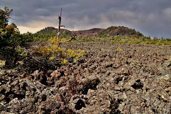
It is only 3,000 years old
The lava in the badlands has been dated to between 2,910 and 3,080 years ago, very recent. Indeed, there were Native Americans living here at that time.
And this is interesting: there is an Indian legend about it! The Pueblo people tell about a river of fire in the San Jose River Valley, so they must have witnessed the outflow of molten rock.
El Malpais National Conservation Area
Created in 1987, the El Malpais National Conservation Area (NCA) protects the environment as well as cultural resources in the "Badlands" of the Grants Lava Flows.
There are many sights that include canyons, sandstone cliffs, the famous La Ventana Natural Arch (Ventana is "Window" in Spanish) and much more.
Ideal for hiking, trekking and picnics. Visit the Malpais Nat. Conservation Area's Official Website for more details.
Ventana Arch in the Malpais, near Grants New Mexico
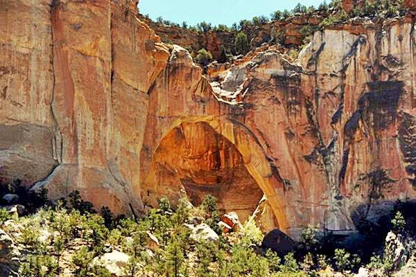
This is a street view of the arch seen from the highway at the scenic viewpoint.
Head south from the junction of Route 66 and I-40 along NM-117. After 9 miles, The road will lead to the Malpais ranger Station, Joe Skeen Camping area (11 mi.), and The Natural Arch of La Ventana. Further south there are several trails leading to Hole In The Wall, Lobo Canyon, and Homestead Canyon.
La Ventana Natural Arch
Visible from the road (there is also a short rough trail). It is the second largest of New Mexico's natural arches (135 ft. - 41 m), it is an arch eroded in the sandstone rock that dates back to the Age of the Dinosaurs.
Continue your Road Trip
Head back to Grants to continue your Route 66 Road Trip.
Sponsored Content

>> Book your Hotel in Albuquerque

Credits
Banner image: Hackberry General Store, Hackberry, Arizona by Perla Eichenblat
Jack DeVere Rittenhouse, (1946). A Guide Book to Highway 66.
Geologic Map of the Zuni-Bandera Volcanic Field


