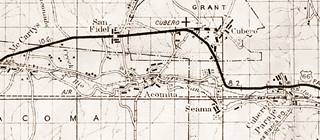
Route 66 in San Fidel NM
Index to this page
About San Fidel, New Mexico
Facts, Trivia and useful information
Elevation: 6,174 ft (1.882 m). Population: 104 (2025).
San Fidel is a tiny village in Cibola County, on the old Route 66 alignment in New Mexico.
History
New Mexico has been inhabited for over 10,000 years. For the past 700 years, the Pueblo people have lived in the valleys of the rivers that flow from the Rocky Mountains into the Rio Grande Basin, such as the San Jose River and use their water to irrigate their crops of maize, squash and beans.
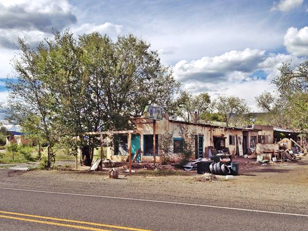
Old Route 66 Cafe in San Fidel, NM
The Spanish explorer Francisco Vásquez de Coronado's visited the nearby Acoma Pueblo in 1540. The Spaniards subdued the Pueblo people in 1589 and incorporated the territory into their empire as Nueva Mexico.
Missions were establish to convert the heathen Pueblo to Catholicism. After an uprising in 1680 known as the Pueblo Revolt the Spanish were expelled. But they returned in 1692 and reconquered the region.
The native name for San Fidel is "Púñi Tsiama" which means "West Dorway", appropriate since it was the entrance to Laguna Pueblo from the west.
After its independence from Spain in 1821, Mexico ruled New Mexico, but was forced to cede it to the US after being defeated in the Mexican - American War (1846-48).
Baltazar Jaramillo, with ancient Hispanic roots settled here in 1868, at "La Vega de San Jose" (St. Joseph's meadow). It was also known as "Rinconada" (Spanish word for a meadow protected and enclosed by a meander on a river, it means "the corner spot". The 1883 USGS map shows it under the name of San Jose.
There was a post office named Ballejos here between 1910 and 1919, then it switched its name to San Fidel. Ballejos or Vallejos is a Spanish surname.
Abdoo Habib Fidel (c.1882 - 1958) was born in the village of Roumine in Nabatiye, Lebanon, then part of the Ottoman Empire. In 1913, Fidel immigrated to the United States, one of many Christian Arabs escaping the though conditions on the Turkish empire. He settled in Cibola in the early 1900s. and became an itinerant merchant, peddling good so the natives and settlers alike from his wagon. Then he opened his store, a general mercantile business in Ballejos. He also sold the local crafts of the Acoma pueblo women, ceramic wares, textiles. He grew into an Indian curio store and associated with Herbert Harvey from Winslow Arizona, shipping goods nationwide. his Curio shop is still standing, and it is a Historic Site. (1).
The name: San Fidel
Fidel is the Spanish name of two saints, St. Fidelis of Como (IVth century) and St. Fidelis of Sigmaringen (1577-1622). Fidelis is latin for "faithful", "loyal" and "sincere". But we aren't aware of the origin of the Syrian surname Fidel, perhaps it is a deformation of "Fadel" an Arabic surname derived from a personal name that means "honorable."
In 1926, Route 66 was aligned along the "Old National Trails" that linked Gallup and Grants with Albuquerque, the highway it passed through the San Jose River Valley, and it crossed San Fidel, where it remained until bypassed by I-40.

Where to Stay: Find your Hotel close to San Fidel
There are no motels or hotels in San Fidel, but neighboring Albuquerque and Grants have plenty of lodging options for those driving along Route 66. You can book a hotel or motel in either town:
>> Book your Hotel in neighboring Albuquerque, Acoma Pueblo, or Grants
More Lodging Near San Fidel along Route 66
Below you will find a list of some of the towns along Route 66 in New Mexico. Click on any of the links to find your hotel, motel or accommodation in these towns (listed from east to west):
On Route 66's Main alignment
The Santa Fe Route 66 segment
Eastwards
Westwards
>> There are RV campgrounds near San Fidel at Acomita or at Grants.
The weather in San Fidel
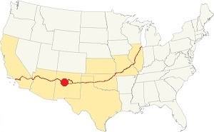
Location of San Fidel on Route 66
The weather in San Fidel is dry and sunny. The arid climate causes cold winters and hot summers. There are 278 sunny days per year.
The average high temperature in summer (Jul) is 89°F (31.7°C) and the average summer low is 56.3°F (13.5°C). During winter (Jan) the average high is 47.4°F (8.6°C) and the average low is below freezing: 17°F (-8.3°C).
Rainfall averages 10.5 inches (292 mm) per year, with most rainfall (6 in. - 152 mm) concentrated between July and October during the "Monsoon" period. There are 53 days with precipitation per year. Snowfall is around 18 inches and may fall between November and March.
Tornado risk
The tornado risk in San Fidel is nil: Cibola County has no Tornado watches. The area west of this point has no tornado events at all.
Tornado Risk: read more about Tornado Risk along Route66.
Map U.S. 66 in San Fidel New Mexico
Maps of Route 66
The 1920s-60s highway then went through San Fidel. See this Budville-San Fidel alignment map. Then it continued west and is now cut by I-40 at Exit 96, built in the mid 1950s as you can see in this map west of San Fidel.
The gap at Exit 96 is shown with a red line in our custom map. The highway continues with a NE to SW course as the South Frontage road of the freeway towards Mc Cartys, the next town on Route 66.
Route 66 Alignment near San Fidel
With maps and full information of the old roadway.
- Lupton to Winslow (next)
- Albuquerque to Lupton (San Fidel's)
- Santa Rosa to Albuquerque (previous)
The Santa Fe Loop (1926 - 1937)
Our Santa Fe Loop page describes the complete 1926 to 1937 alignment of Route 66 from Santa Rosa to Albuquerque through Pecos, Santa Fe and Bernalillo.
Route 66 Attractions in San Fidel
Landmarks and sights for your Road Trip
Historic Context
Jack Rittenhouse mentions the village in his Guidebook to U.S. Highway 66, published in 1946:
San Fidel (Pop. 128.... cafe; gas; small garage; curios; store; no cabins or other accommodations.) San Fidel was originally a busy trading center; today it has declined somewhat. Rittenhouse (1946)
Two miles west of it, he mentioned another spot: "Chief's Rancho Cafe here, with gas, grocery, curios, and cafe," it is the site of the ruins of what later became the Whiting Bros motel and gas staion complex.
Drive US66 in San Fidel NM
Heading west from Villa de Cubero after the "Los Cerrillos" gas station, Rittenhouse had mentioned that here "the region appears more desolate" and it is. Just 2.3 miles west of Los Cerrillos you reach San Fidel. Here there is a bridge across an itermittent stream on the eastern side of the village. It was built in 1936 replacing an earlier one. We believe that here, on the eastern side of the village, by the stream was the site of the only campsite in town.
San Fidel Camp
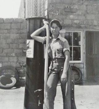
Genta Rice at her father's Texaco, US66 San Fidel. Source
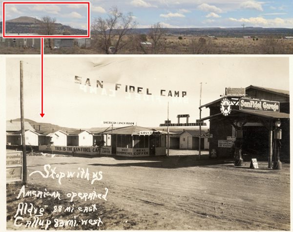
The campsite had a Grocery store, the San Fidel Garage selling Texaco gasoline, and an "American Lunch Room", the postcard states it was "American Operated" (rather than Mexican? Pueblo? Hispanic?). Despite Rittenhouse's statement that there were no cabins in town, this one offered a Camp Grounds for ¢25, and cabins for $1.00
It was owned and operated by Roscoe Conklin Rice (1882-1959), Roscoe had come from Minnesota and settled here with his wife Olivia Grace née Brown. They were the parents of ill-fated H. N. "Bud" Rice, who was murdered in 1967 in his Budville Trading Post.
Roscoe Rice was postmaster of Cubero during one year in 1921 and was succeeded by his wife from 1922 to 1946. So they seem to have moved along the San Jose river communities.
The picture shows Roscoe's daughter Genta by the Texaco pumps of her father's store and gas station. Genta Neionta Chapman (Rice) (1916-2003) was "Bud's" sister. Later she recalled that even after Prohibition was repealed in 1933, moonshining was an additional source of income for those living in the area adding that "her mother's store in Cubero, selling 100-pound sacks of sugar and local Indian-grown corn to customers. Cork stoppers were a big seller, and local kids earned penny candy by bringing in empty bottles they found" (2).
The site's location is a conjecture based on the shape of the hills and mesas that you can see in the background, which you can see in the image combining a 1930s postcard with its current view. It probably went out of business during the drop in traffic during WWII.
As you enter the village, to your left was Ramsey's Cafe long gone. To your right is a more recent building, the Zodiac Bar.
Zodiac Bar
Also known as Zodie's Grill, it has a decrepit 1960s neon sign. At one time it was ran by Rose and Reynaldo "Ray" Maestras with their children. Since the mid 2000s it has been Zodiac Bar.
Next door is a former gas station that became another cafe.
San Fidel Geezerville
To your left, with a restored Texaco signpost that is inscribed with a U.S. 66 shield on one side and by a Zia sun symbol on the other, with the words "San Fidel, New Mexico Geezerville."

Just ahead, to your left, on the south side of the highway is the historic Trading Post:
Acoma Curio Shop
1090 NM 124 (Route 66), San Fidel, NM.
Listed in the National Register of Historic Places, US National Historic Landmark
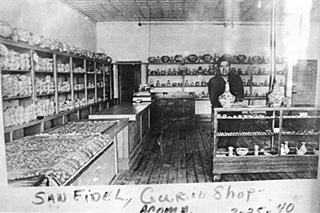
Acoma Curio Shop. 1940 US66 San Fidel. Source. Click to enlarge
The Acoma Curio Shop or Trading Post was a classic Route 66 store dealing in local Acoma native handicrafts during the 1920s and 30s.
The adobe store has a false wood front and was built around 1916 by Abdoo Habib Fidel (we included his bio further up, in the History section), a Lebanese immigrant who opened his mercantile store that later switched to selling local native arts and crafts wholesale and retail.
The black and white picture shows the interior of Acoma Curio Shop taken on April 25, 1940 with Alvin Concho Lewis.
Business grew during the 1930s thanks to Route 66, but with rationing during WW II, sales fell killing off his business. In 1947 Fidel leased the land to Standard Oil Co. which opened a gas statiuon, and shortly after he sold it. Fidel retired to Grants where he died in 1958.
Acoma Curio Shop, San Fidel, NM
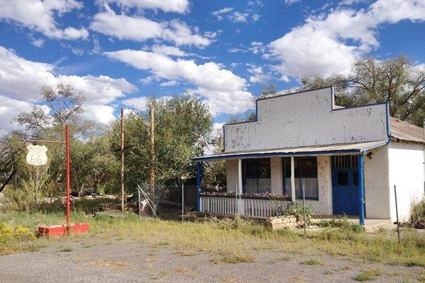
Tafoya Cafe
Across the highway, on the north side is the former Tafoya Cafe with its faded neon sign. Leon Tafoya, a resident of San Fidel, and Mayordomo of Acequia San Jose de la Cienega (the irrigation channel's Steward) recalled that his father who was a chef for the Harvey Houses on the A.T. & S.F. railroad for fourteen years, opened his own restaurant here in San Fidel in the 1940s, the Acoma Cafe (3).
Cafe Trivia from the 1970s: "A bombing incident took place in san Fidel Early sunday dynamite stick placed on the Side Wall of rays bar exploded and broke two windows on the Leon Tafoya Home located next door to the bar. No estimate was made of the damage caused by the bomb and no suspects have been found." This was reported in the 29 May 1975 Issue of Los Lunas Valencia County News (4).
Old Tafoya Cafe in San Fidel, NM
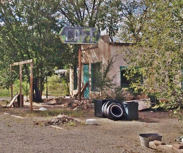
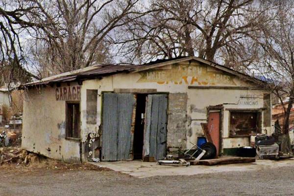
To your left is the old garage:
White Arrow Garage
The White Arrow Garage dates back to the 1940s it is surely the "Small Garage" mentioned by Rittenhouse in 1946. It is slowly falling apart but still holding up against the ravages of time.
St. Joseph the Worker Mission
San Fidel became a parish in 1921. It had been chosen for its central location among the other towns in the area. Its church had been built in 1920 and was dedicted to Saint Joseph the Worker. It is just ahead, to your left.
As you leave the village, to your right is a two-story building, that had been the home of A. H. Fidel and his family.
Jack DeVere Rittenhouse mentions that along the highway in this area there were Indians selling pottery, and noted the Acoma ware they sold.
Whiting Bros Gas Station and Motel
2.7 miles west of San Fidel, on old US66 and 0.5 mi. east of I-40's Exit 96. North side of the road and another sign on the south side. This spot is also called the McCarty's Whiting because McCartys is close (just 5 mi. west). The signs can also be seen from the westbound lanes of the freeway.
Chief's Ranch
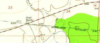
The Whiting station evolved from a tourist travel center built around 1940 and that was mentioned in 1946 by Rittenhouse's "Guidebook to Route 66" as two miles west of San Fidel: "Chief's Rancho Cafe here, with gas, grocery, curios and cafe." The USGS map shows it under the name "Chief Rancho", and it is interesting to see it is right beside the border of the Laguna Reservation.
Their postcard below simply states "Chief Rancho" and depicts two Native Americans in a tribal attire that does not seem to be of the Pueblo people and there is a teepee in the background, which was definitively not used in this region.
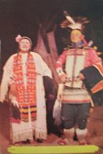
1940s postcard. Chief Rancho. Source
Whiting Bros. San Fidel over the years
Below is a black and white photo taken in 1996, above is the same view nowadays. As both images show, the motel and service station have changed a lot over the course of the years, slowly falling apart as time inexorably goes by.
1996 picture by Kōzō Miyoshi
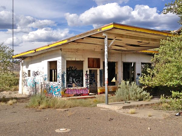
More views of the old Whiting Bros. complex:
Old neon sign of the Whiting Brothers Service Station and Motel near San Fidel, Route 66, New Mexico
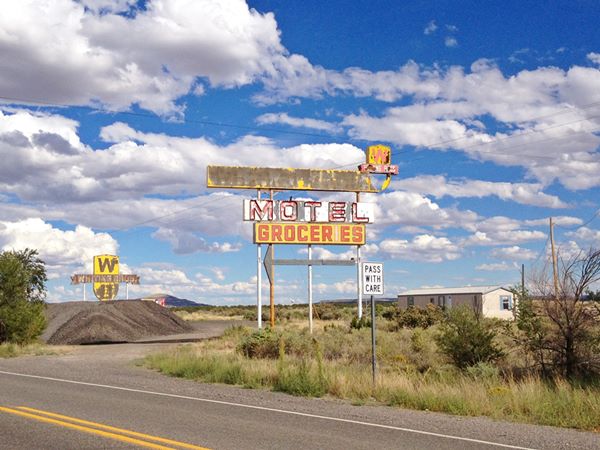
The sign above reads: "Whiting Bros - MOTEL - groceries", and has an arrow pointing towards the vacant lot (the motel burned down in the 1990s). To the east is the brand's yellow shield with the letters "W B" and the words "Whiting Bros." on a red ribbon across it.
Abandoned Whiting Brothers Service Station near San Fidel, Route 66, New Mexico

>> Read more about all the Whiting Bros. Route 66 gas stations and motels.
Continue your Road Trip
This old gas stawtion marks the endpoint of your trip through San Fidel.
Your Route 66 journey continues by heading west into the next village, McCartys NM.
Sponsored Content

>> Book your Hotel in Albuquerque

Credits
Banner image: Hackberry General Store, Hackberry, Arizona by Perla Eichenblat
Jack DeVere Rittenhouse, (1946). A Guide Book to Highway 66.
NPS, Acoma Trading Post, Route 66 Corridor Preservation Program


