Route 66 in Rehoboth NM
Index to this page
About Rehoboth, New Mexico
Facts, Trivia and useful information
Elevation: 6,581 ft (2.006 m). Population: n⁄a (2025).
Time zone: Mountain (MST): UTC minus 7 hours. Summer (DST) MDT (UTC-6).
Rehoboth is an unincorporated community located just off Route 66, in McKinley County, New Mexico, 5 miles east of Gallup.
History
The area where Rehoboth is located has been populated for the last 10,000 years. The Paleo-Indians later evolved into the Historic Zuni and Navajo people that were encountered by the Spanish when they reached the area in 1540.
The Spanish expedition led by Francisco Vásquez de Coronado passed through this area (Zuni Pueblo) but did not settle here, they were seeking gold. Settlement under the Spanish crown began in 1597 and lasted until 1821, when Mexico became independent and the territory became a part of the new country.
The fierce Navajo people never allowed the Spaniards to settle the area and for over 200 years they raided their pueblos of Zuni, Laguna, Acoma and others on the Rio Grande River and close to Santa Fe and Albuquerque.
After the Mexican - American War (1846 - 48) in which Mexico was defeated and ceded New Mexico to the US, the American Army took action to subdue the Navajo warriors.
The army established the first Old Fort Wingate near Grants in 1862, and used it as a base for its campaigns. Once the Navajo had been defeated and confined to the Navajo Reservation, the fort was moved it to its present location in 1864, at Wingate, just to the east of Rehoboth on the old wagon road linking Albuquerque, the Laguna Missions and the land of the Navajo, with Fort Defiance on the Arizona - New Mexico border.
In 1881, the Atlantic and Pacific Railroad (later purchased by the Atchison Topeka & Santa Fe Railway) laid its tracks across the Continental Divide and down the Western Rio Puerco River towards Gallup. They set up a station 6 mi. east of Gallup and called it "Zuni".
The Mission, background and history
The Protestant Reformation in the early 1500s led to the appearance of different Christian Churches, one of them was inspired by John Calvin and flourished in the Netherlands; it later became the state church which persecuted a branch that had split from it: a "grassroots" movement that became the Christian Reformed Church (CRC), a branch of Dutch Calvinism.
The CRC leaders decided to escape famine and persecution by migrating to America in 1848. They settled in Holland, Michigan and soon built ties with the American Dutch Reformed Church in New York and New Jersey. But in 1857 part of the flock seceded and as a result, the Christian Reformed Church was born.
They spread out over American to preach and find new places to settle. In 1896 they began their ministry among the Navajo people in New Mexico and the following year, among the Zuni people. In 1899 a church was organized in Fort Defiance (in Arizona, just next to the New Mexico border, in Navajo Territory).
They decided to settle in an area closer to the Natives and chose a spot 5 miles to the east of Gallup, next to the stage road and the railway. They named it Rehoboth.
The name: Rehoboth
The name is of Jewish origin, and is found in the Bible. It is a Hebrew word רְחוֹבוֹת (Rehovot) meaning "broad places", "room". And the vers that inspired the mission's name are found in Genesis 26:22, where Isaac names a well "Rehoboth".
«He moved on from there and dug another well, and no one quarreled over it. He named it Rehoboth saying, "Now the Lord has given us room and we will flourish in the land"»
On October 1, 1903 they held the first service at the Rehoboth Indian Mission, in the settlement they created in New Mexico. By 1906 they had organized the first permanent church organized in New Mexico by moving the Fort Defiance chuch there.
The Rehoboth Mission Hospital was organized in 1910. That year the post office was created and named Rehoboth.
Navajo Reservation
The Reservation spans over 9 million acres and lies 20 miles north of Rehoboth. Larger than Massachusetts and New Jersey together.
The Navajo are actually the Diné people, which in their language means jut that: "The People". The Spaniards called them "Apaches de Navajo", after an old Tigua pueblo, Navahu.
In 1914 New Mexico State Highway #6 was built following the railroad and was as part of the National Old Trails Highway system. In 1926 Route 66 was aligned just 0.1 miles to the north of the village which also included a boarding school for the Navajo children which were "Americanized" in what was believed the best method in those days: they dressed them like "white men", taught them English, cut their hair and tried to erase their native culture.
Beginning in the late 1950s, the Interstate system gradually replaced Route 66, which in this section is preserved as the North Frontage Road of I-40, and is a >Historic Landmark.

Where to Stay: Find your Hotel near Rehoboth
There are no lodgings in Wingagte but you will find several accommodation options on Route 66 in neighboring Grants (to the east) or Gallup (west) so you won't have difficulty to book your room:
> > Book your Hotel in Gallup
More Lodging Near Rehoboth along Route 66
Below you will find a list some of the towns along Route 66 east and west of Rehoboth; click on any of the links to find your hotel in these towns.
Below you will find a list of some of the towns along Route 66 in New Mexico. Click on any of the links to find your hotel, motel or accommodation in these towns (listed from east to west):
On Route 66's Main alignment
The Santa Fe Route 66 segment
Eastwards
Westwards
>> There are RV campgrounds close by, at Gallup
The weather in Rehoboth

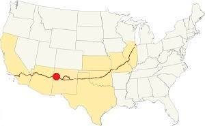
Location of Rehoboth on Route 66
Rehoboth is located close to the continental divide in the Rocky Mountains in western New Mexico. Its climate is dry and semi-arid. Summers are hot summers (with cool nights) and winters are cold.
There is a great temperature swing between day and night due to the dry air and the altitude. Expect cold winter nights and fresh summer ones.
The average summer high temperature is about 89°F (32°C) with an average low of 51°F (11°C). Winter average high is 45°F (7°C) with an average low below freezing: 11°F (-12°C).
Rainfall is scarce: 11.5 in (292 mm) per year. Most falls between July and Nov. (6.81 in or 173 mm). There are about 70 days per year with precipitation each year.
Snow is frequent and quite heavy during winter (30.4 inches or 77.2 cm). You may encounter snow at any time between October and May.
Tornado risk
There is no tornado risk in Rehoboth: McKinley County has no Tornado watches. Route 66 west of the Rio Grande River in NM and all the way to California has no tornado events at all.
Tornado Risk: read more about Tornado Risk along Route66.
Map U.S. 66 in Rehoboth New Mexico
Maps of Route 66
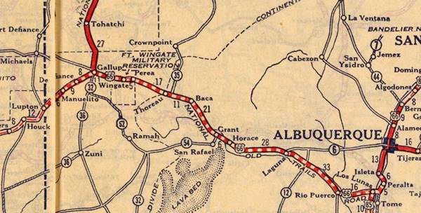
Read the Detailed Description of this segment (Albuquerque to Lupton). Below is the interactive map:
>> Custom map of Route 66 in Rehoboth

Perea to Gallup
Perea ruins lie on the south side of the highway at its junction with Hwy 27. From here you have a 14 mile-long uninterrupted course into Gallup as shown in this map: Perea to Gallup map going through Wingate and Rehoboth.
Gallup
The city of Gallup is the largest in the western New Mexico alignment of Route 66. The highway crossed the town from east to west as shown in the following map, and runs westwards for 10 mi. without any gaps until it reaches Defiance. US66 map west of Gallup to Defiance.
Route 66 Alignment near Rehoboth
With maps and full information of the old roadway.
- Lupton to Winslow (next)
- Albuquerque to Lupton (Rehoboth's)
- Santa Rosa to Albuquerque (previous)
Rehoboth: its Attractions
Landmarks, Route 66 sights in the Mission
Historic Context
In 1946, Jack DeVere Rittenhouse wrote his "Guide Book to Highway 66" which, from east to west, mentions the nearby villages of Perea, the entrance to Fort Wingate and the historical marker that pointed towards the Kit Carson Caves.
Closer to Rehoboth was the now gone Kirk Brothers Trading Post ❌ which had a "store, cabins no gas" and finally the entrance to "Rehoboth Mission off US66". To the west, was Gallup.
The location: red sandstone hills
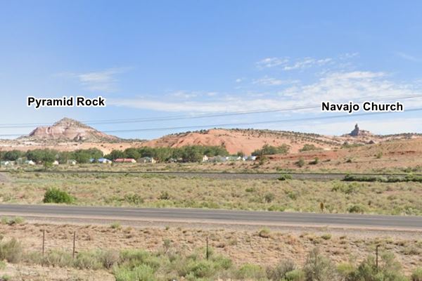
Navajo Church
This natural feature is on the north side of the road, and is a sharp rocky pinnacle of white sandstone around 200 ft. high (61 m) mounted on top of red sandstone. It is a sacred spot for the Navajo people. They are rocks from the Jurassic period, 140 to 180 Million years ago, laid down when this area was a shallow sea. The beaches and sand dunes formed these sandstone sediments.
Pyramid Rock
Just west of the "church" is another sandstone hill shaped like a cone, the Pyramid Rock.

The "sign" at Rehoboth
A Biblical verse sign
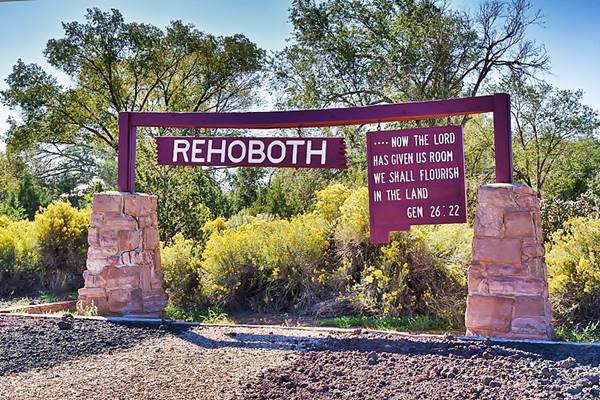
Sign at Rehoboth with a Biblical verse; Rehoboth, New Mexico

There is a very interesting sign in Rehoboth, it is a wooden structure mounted in two roghly hewn stone columns, which has two signs hanging from its upper beam.
The sign is shown in the image above.
One says in bold white letters: "REHOBOTH", and the other "... Now the Lord has given us room we shall flourish in the land. Gen 26:22".
The sign post is located here: Street view
The Church Rock Uranium Mill Spill
The dam site is located 13.6 miles by road from Rehoboth, east along US 66 and then north along NM-566; this Map shows how to get there.
A little known fact about a nuclear accident in western New Mexico.
On July 16, 1979, at the United Nuclear Corporation's facilities in Church Rock, a dam that contained a disposal pond with the tailings of a uranium mill burst. The contents spilled out and ran downhill along a stream that flowed into the Western Rio Puerco River, the mass of contaminated water and radioactive mill waste sludge continued downstream for 80 miles (130 km) all the way into Navajo County and the Navajo Nation in Arizona.
More than one thousand tons of solid waste and 93 million gallons (352.050 m3) of acidic sludge, all of it radioactive, were spilled in this accident.
It released more radioactivity into the environemnt than the more famous Three Mile Island reactor event which happened that same year.
The spill contaminated groundwater and the Puerco River water used for irrigation and livestock became unusable.
Only 2 nuclear disasters have released more radiation: those at Fukushima and Chernobyl.
Currently the abandoned uranium mines and the spill site are monitored.
Further reading see the EPA Report The Church Rock Uranium Mill Tailings Spill and Stanford University's report.
Church Rock
This small village is also known by its Navajo name: "Tsé Íi'áhi" which means "Rock Pinnacle" and also "Kin Litsoí Sinil" meaning "Yellow Houses Place", in allusion to the houses built for Navajo workers at the Fort Wingate ammo Depot during World War II.
It is located 3.3 miles east of Rehoboth, on the north side of I-40, Route 66 and the railway tracks. Just next to the entrance to Red Rock Park.
The first building in the area was the "Outlaw Trading Post" ca. 1884. Nowadays there is a Trading Post with the same name in the area.
It is not mentioned in Rittenhouse's 1946 Guide Book to Route 66, and it did not appear in many maps printed between 1927 and 1959. A native town in the land of the Navajo.
Continue your Road Trip
Your journey through Wingate ends here. Head west into the next town: Gallup NM, to continue your Route 66 Road Trip.
Sponsored Content

>> Book your Hotel in Albuquerque

Credits
Banner image: Hackberry General Store, Hackberry, Arizona by Perla Eichenblat
Jack DeVere Rittenhouse, (1946). A Guide Book to Highway 66.

