On the 1950s Route 66 into St. Louis
Index to this page
- About Fairmont City
- Weather
- Hotels in Fairmont City
- Map of US 66 in Fairmont City
- What to see and do in Fairmont City
About Fairmont City, Illinois
Facts, Trivia and useful information
Elevation: 420 ft (128 m). Population 2,147 (2024).
Time zone: Central (CST): UTC minus 6 hours. Summer (DST) CDT (UTC-5).
Fairmont City is located in Madison County close to the Mississippi River in Southwestern Illinois.
History of Fairmont City
What is now Illinois has been inhabited for at least 12,000 years, since the end of the last Ice Age. One thousand years ago, the Native Americans of the "Mississippian culture" lived here. Their capital was located at the Cahokia Mounds on the eastern side of Fairmont City. Learn more about the History of Madison Couty.
The townsite was born in 1910, when the Pennsylvania Railroad built a roundhouse here. In 1913 American Zind, Lead and Smelting Co. set up a large ore processing plant in the area
and this attracted migrants from Central Europe and Mexico (Czechoslovakia, Poland, Croatia), a melting pot that gave the town its motto "A Road to America".
Its original name was Willow Town. Located on strategic Route 40 it provided services to those using the highway. Later, in the mid 1950s U.S. 66 was aligned beside U.S. 40 across the town.
The Name:Fairmont City
It adopted the name in 1914 when it became a village, the name originally refers to a hill ("mont") that has a pleasant view ("fair"), probably an alusion to the nearby Indian Mounds, east of the town towards Collinsville.

Hotels and Motels: Fairmont City, Illinois
There is accommodation on Route 66 in Fairmont City:
> > Book your accommodation in Granite City
More Lodging near Fairmont City along Route 66
Below you will find a list of some of the towns along Route 66 east and west of this town; click on any of the links to find your accommodation in these towns (shown from east to west):
Along Route 66 in IL
- Hotels in Illinois
- Route 66 Starting point ▸ Chicago
- Lockport
- Willowbrook
- Bolingbrook
- Plainfield
- Romeoville
- Joliet
- Wilmington
- Dwight
- Pontiac
- Chenoa
- Normal
- Bloomington
- Atlanta
- Lincoln
- Springfield
- Raymond
- Litchfield
- Staunton
- Williamson
- Hamel
- Edwardsville
- Collinsville
- Troy
- Glen Carbon
- Pontoon Beach
- Granite City
- East St. Louis
West in Missouri
- Hotels in Missouri
- Florissant MO
- Bridgeton MO
- St. Louis MO
- Kirkwood MO
>> Check out the RV campground in neighboring Granite City
The Weather in Fairmont City
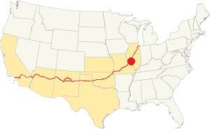
Location of Fairmont City on U.S. Hwy. 66, Illinois
Rainfall in Fairmont city averages 41 in. (1.041 mm) per year. The most rainy months are from May through July with more than 4.1 in per month (104 mm). Snow falls from Nov. to April: 17.8 in. (45 cm). The town has four clearly defined sesons and it is located in the area where humid continental climate shifts towards a humid subtropical climate, so summers are hot and humid while winters are cold. It gets cold Arctic air and hot damp tropical air from the Gulf of Mexico. Spring is wet and may have extreme weather (tornados, thunderstorms and even winter storms). Fall is sunny and less humid, with mild weather.
The average winter high (Jan) is a chilly 39.9°F (4.4°C) and the winter low is on average 23.7°F (-4.6°C). The summer (Jul) average high is 89.1°F (31.7°C) and the average low is 71°F (21.7°C).
Tornado risk
Fairmont City may be hit by some 7 tornados every year. Tornado Risk: read all about Tornado Risk on Route 66.
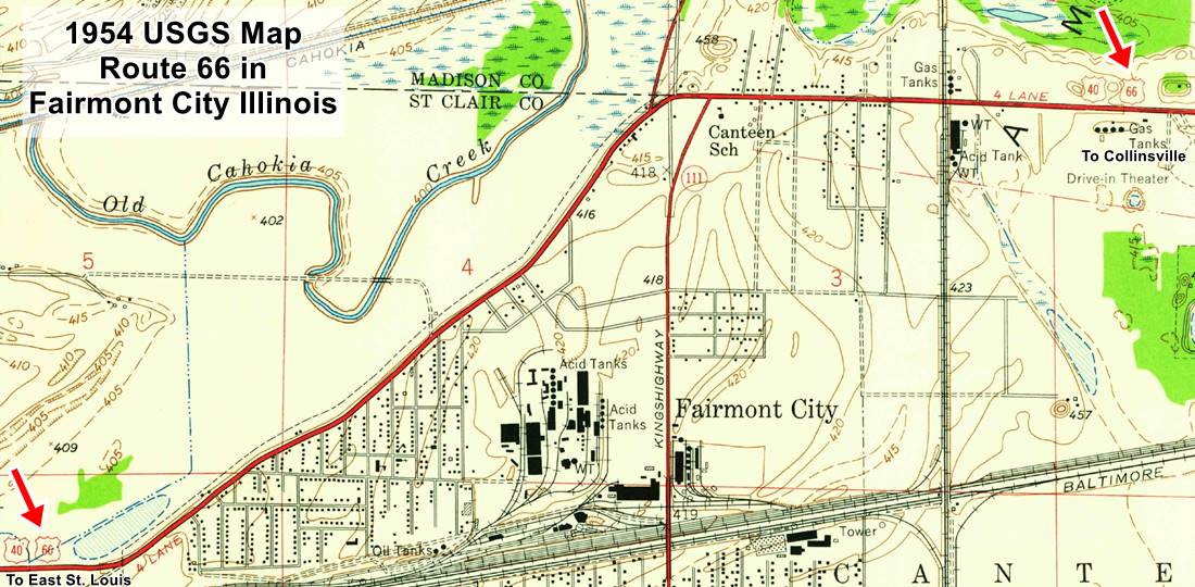
Map of Route 66 through Fairmont in Illinois
The thumbnail map -click on it for a full size map- shows the alignments of US66 & US40 through Fairmont in 1954.
The highway comes from Collinsville to the east (right) into East St. Louis in the west (left).
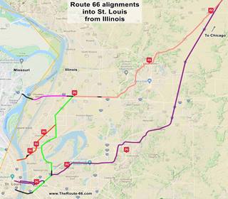
You can see this alignment marked withy the violet line in this other map.
This is the color key for this map is the following:
Orange: is first, it shows the original 1926-32 aligment of US66 into St. Louis MO; this one didn't go through East St. Louis.
Pink is the Bypass US-66 that crosses the Chain of Rocks Bridge further north and the Pink line marks its approaches from Hamel.
Green and Yellow are other alignments that went through East St. Louis.
Violet, the latest 1954 alignment from Hamel through Troy and Fairmont City, into East St. Louis.
Black: missing segments that can no longer be driven.
This is a Map with directons in Fairmont City.
The Route 66 alignment in Fairmont City
Visit our pages with old maps and plenty of information about US 66's alignments.
- Route 66 St. Louis to Gray Summit (next)
- Route 66 Hamel IL to St. Louis MO (In Fairmont City)
- Springfield to Hamel IL (1930-77 previous)
- Springfield to Staunton IL (1926-30 US66 previous)
Route 66 Sights in Fairmont City
Landmarks and Places to See
Sponsored Content
Attractions: Drive along Route 66
Rittenhouse does not mention Fairmont City in his 1946 "Guidebook to US 66" because the road through Fairmont wasn't Route 66 at that time (only US40). He took the bypass alignment from Mitchell west, across the Chain of Rocks Bridge and then along BYP 66 north and west of St. Louis.
At that time, City Route 66 barely grazed western Fairmont City: coming from Granite City it met US40 and turned west into East St. Louis. Only in the 1950s was the higway aligned south of Hamel through Troy, Collinsville and then together with US 40, along Collinsville Road through town.
After passing the Cahokia Mounds, continue westwards into Fairmont from the west, along Route 66 and Historic Route 40. To your left is a motel from the 1950s.
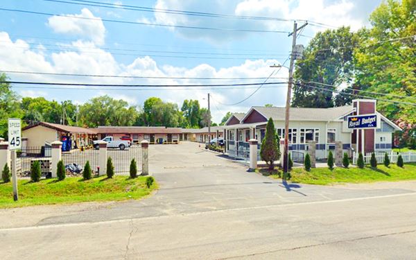
Royal Budget Motel
At 6016 Collinsville Rd.,it has a U-shaped layout around a central parking area. The single-story gable roof complex has been here at least since 1955 (see this aerial photo taken in 1955).
Former Rainbo Court Motel
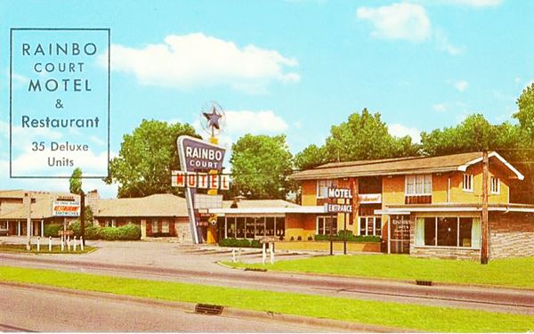
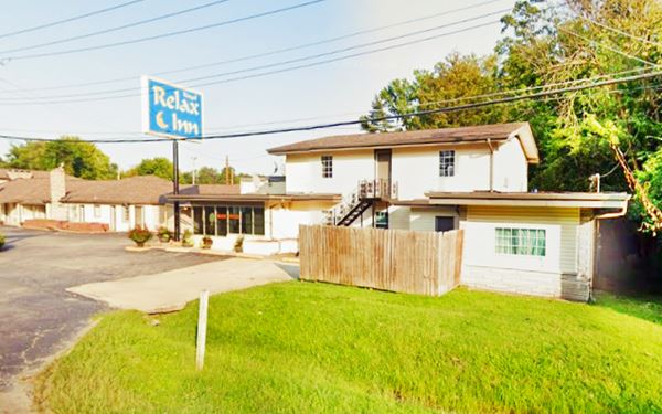
Ahead, after the curve, the highway adds a median strip and, to your left, at 5280 Collinsville Road is another 1950s motel the Rainbo Court Motel (now Royal Relax Inn).
In its postcard, the Rainbo Court Motel & Restaurant promoted its "35 Deluxe Units"; its classic neon sign has been removed. The building's exterior is relatively unchanged since the 1950s. The postcard said it was in Collinsville despite being located in neighboring Fairmont City.
Former Rainbo Court Motel in Fairmont City, Illinois
Old Rainbo Court Motel nowadays as the Royal Relax Inn in Fairmont City, Illinois
Indian Mound Motel
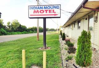
Head west, and ahead, to your left at 4700 Collinsville Rd. is another motel that appears in the 1955 aerial photo mentioned further up, the Indian Mound Motel. Originally it has a linear lay out facing the highway, another wing was added closer to Route 66 in the late 1950s-early 1960s. It is still open.
Further east, to your right, just next to the Public Library is a Classic Neon Sign
Nite Spot Café
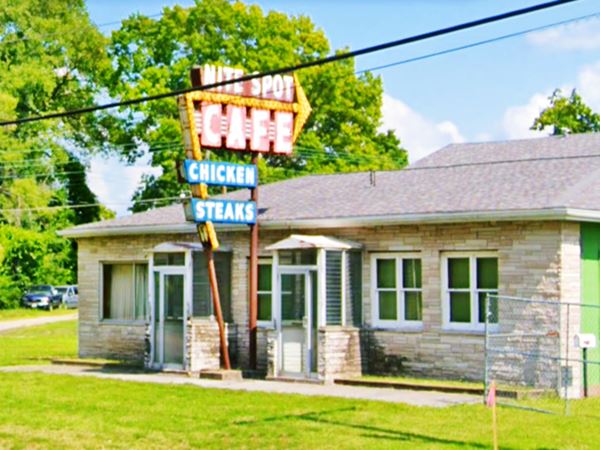
To your left, at 4448 Collinsville Road is a classic cafe that served tourists and truck drivers, 24 ⁄ 7. Adam and Anne Galas purchased the building in 1947. The cafe is closed, and it sports a classic 1950s Neon Sign.
In 2018 it was declared one of the Most Endangered Historic Places in Illinois by landmarks.org after the city condemned the building.
Nite Spot Café with its Neon Sign in Fairmont City, Illinois
Thomas Garage
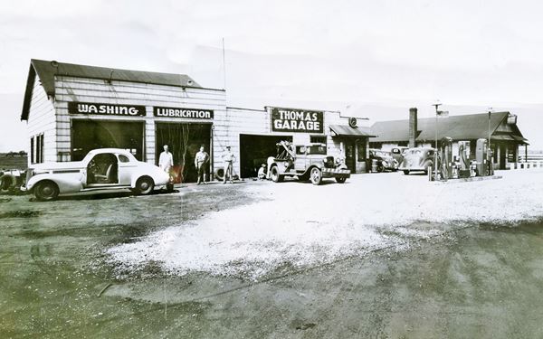
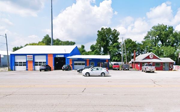
Just ahead, at 3619 Collinsville Rd., to your right is the garage and gas station that Jimmy Thomas opened in 1931. It also had "Thomas Wrecker Service" and sold gas. The place has changed a bit since then, but the gable roof building on the right, "Buzz's Firehouse Bar" is the same, chimney and all, as you can see in the "Then and Now" sequence below:
Old Gas Station?
Ahead, to your left, at 3403 Cookson Rd & 3401 Collinsville Rd. is Bravo License. It appears in the 1955 aerial photograps and it seems to have been a gas station. This is its street view.
Route 66 meets City 66
Collinsville Road Junction
Below you can see a map showing City 66 marked with red arrows. It comes from the upper right close to Edwardsville, through Granite City and reaches (lower left) airmont City.

US 66 from Edwardsville to Fairmont in 1949. USGS Map

City 66 junction with Collinsville Rd in satellite view and 1940 USGS Map
click image for satellite view
Route 66 with Alt US 67 followed the City 66 alignment (see this map with directions. It reached Collinsville Rd. and met US 40, and they all headed westwards into East St. Louis.
As you can see in the image that combines a satellite view of its present appearance (the red arrows show the old roadbed) and a 1940 USGS map, part of the original roadbed is still there next to the motel.
View of former US 67A and US 66 from Exit 4 of I-55 in Fairmont City, Illinois
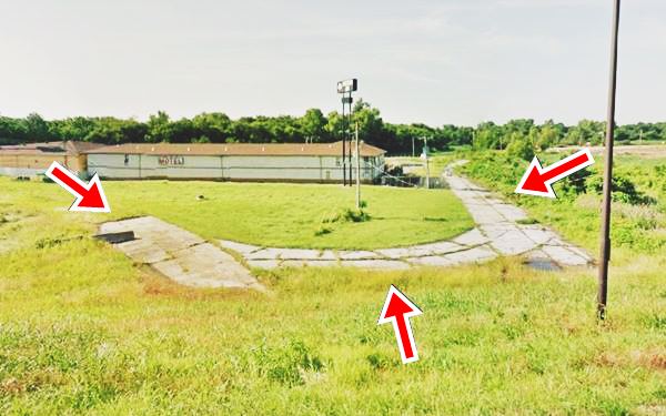
In 1954, Route 66 was realigned along Collinsville Rd. and the City 66 was eliminated.
This marks the end of this leg of your Route 66 road trip in Illinois and East St. Louis, continue westwards in St. Louis Missouri.

Sponsored Content
>> Book your Hotel in Chicago

Credits
Banner image: Hackberry General Store, Hackberry, Arizona by Perla Eichenblat
City website fairmontcityil.com


