The Gateway to Chain of Rocks Bridge
Index to this page
All about Mitchell on Route 66
Trivia, Useful Information & Facts
Elevation: 419 ft (120 m). Population 1,356 (2010).
Time zone: Central (CST): UTC minus 6 hours. Summer (DST) CDT (UTC-5).
The small hamlet of Mitchell is an unincorporated census-designated place in Madison County, Illinois. Part of the Metro East region of greater St. Louis.
History of Mitchell
Humans have lived in Illinois since the retreat of the glaciers at the end of th last Ice Age some 12,000 years ago. Just to the south of the town, halfway to Long Lake are "Indian Mounds" these are known as The Mitchell Archaeological Site, listed in the National Register of Historic Places, comprising a platform mound and the remains of a village dating to 1150-1200 A.D.
The mounds were ceremonial and burial sites of the native "Mississippian culture" flourished here from 900 A.D. to 1500 A.D., their capital was located at Cahokia Mounds (near Collinsville). They were farmers and hunter-gatherers. Famine due to drought led to their demise.
During the 1600s Illiniwek natives (Peroria, Kaskaskia, Kahokia, and more) moved here escaping war with the Iroquois.
First mentioned by French Jesuits in 1656 who heard about the "Illinois" natives from a party of Algonquins. Father Marquette reached the area in 1673, settling in Kaskaskia and Cahokia. At that time it was a French posession.
France ceded it to Britain in 1763 and then it became part of Virgina after the American Independence, as the County of Illinois in 1778. Ceded by Virginia to the US government in 1784 it became part of the vast North Western Territory in 1787.
After being part of the Indiana Territory in 1809 it became a separate entity: the Illinois Territory which entered the Union as a state in 1818.
Madison County was created in 1812 and named for President James Madison.
Mitchell's post office opened in 1869 (named Long Lake) which changed to Mitchell in 1892. It grew into an industrial region in the 1900s, with steel, oil refining, Granitware and heavy industries. Loss of industrial jobs has reconverted the region into a semi-rural area with a low population.
The Name:Mitchell
Named after John J. Mitchel, who worked on the Alton and St. Louis Railroad. Two brothers, John Jay and William H. Mitchell, from Alton Illinois bought land here, draining the swamps and lobbied with the railroads to build a depot there.
Reaching Mitchell
Get to Mitchell driving along Historic U.S. 66 or take the freeways: I-270 or I-55.

Mitchell: its Hotels and Motels
Lodging & accommodation in Mitchell
> > Book your hotel in Edwardsville
More Accommodation near Mitchell on Route 66
Below you will find a list of some of the towns along Route 66 east and west of this town; click on any of the links to find your accommodation in these towns (shown from east to west):
Along Route 66 in IL
- Hotels in Illinois
- Route 66 Starting point ▸ Chicago
- Lockport
- Willowbrook
- Bolingbrook
- Plainfield
- Romeoville
- Joliet
- Wilmington
- Dwight
- Pontiac
- Chenoa
- Normal
- Bloomington
- Atlanta
- Lincoln
- Springfield
- Raymond
- Litchfield
- Staunton
- Williamson
- Hamel
- Edwardsville
- Collinsville
- Troy
- Glen Carbon
- Pontoon Beach
- Granite City
- East St. Louis
West in Missouri
- Hotels in Missouri
- Florissant MO
- Bridgeton MO
- St. Louis MO
- Kirkwood MO
>> Check out the RV campground in Mitchell
Mitchell's weather
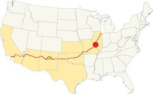
Location of Mitchell on U.S. Hwy. 66, Illinois
Mitchell's average temperatures for Summer (Jul) are 90°F (32.2°C) -high, and 70°F (21.1°C) -low. While the winter averages are (Jan) 36°F (2.2°C) and a chilly 19°F (-7.2°) respectively.
Rainfall his fairly even throughout the year with peaks of 4.2 inches in April and May. With a minimum of 2 inches (51 mm) in January.
Expect snow, ice and sleet in winter.
Tornado risk
Mitchell is in an area that is hit by about 7 tornados per year, so your chances of seeing one are not that large.
Tornado Risk: learn more about the Tornado Risk on US 66.
Map of Route 66 through Mitchell
Alignments of US66
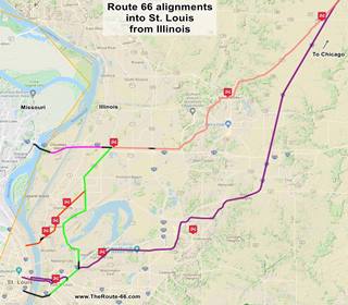
Click on the Map to see a large sized map showing Route 66 alignments that go into St. Louis MO from Illinois.
In this map is Black lines mark the missing segments that can no longer be driven.
Original 1926-54 alignment
The original 1926 coming from Edwardsville ran through Mitchell: 1926 US 66 map
This alignment is marked in pale pink in the map (click on it to enlarge), and continues to the SW in green through Granite City and Madison into St. Louis.
It was used until the new "Main 66" was built from Hamel through Collinsville and Fairmont City into East St. Louis in 1954. Then the segment from Hamel to Mitchell became the Bypass 66.
Main 66 or Bypass 66
The segment of Route 66 known as "Main 66" or "Bypass 66" built and paved west of Mitchell and through the a place called St. Thomas on the northern part of Granite City existed from 1935 to around 1962 (dark pink in the map). It continued across Madison City's northern side on Chouteau Island to the Chain of Rocks Bridge and crossed the Mississippi into St. Louis MO.
See its alignment, now cut by I-270, in this map (Thorngate Rd) and, west of the freeway Bypass 66 map (Chain of Rocks Rd).
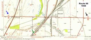
The USGS map published in 1948 below (click on it to enlarge) shows Route 66 reaching Mitchell (black arrow), City 66 heading south into Granite City (green arrow) and Route 66 heading west towards the Chain of Rocks bridge (blue arrow).
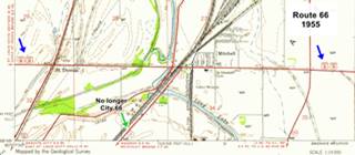
In the second map, published in 1955, It is BYP 66 that enters and exits Mitchell (blue arrows), the old City 66 had been eliminated becoming State Hwy 3 and Main 66 ran far to the east and south through Collinsville.
The Route 66 alignment in Mitchell
Visit our pages with old maps and plenty of information about US 66's alignments.
- Route 66 St. Louis to Gray Summit (next)
- Route 66 Hamel IL to St. Louis MO (In Mitchell)
- Springfield to Hamel IL (1930-77 previous)
- Springfield to Staunton IL (1926-30 US66 previous)
Route 66 across Illinois
Historic Route 66 has been designated as an All-American Road and a National Scenic Byway in the state of Illinois.
Click for a description of Route 66 in Illinois.
Mitchell: its classic Route 66 Sights
Attractions & Landmarks
Historic context: the Golden Days
Jack DeVere Rittenhouse published his "A Guide Book to Highway 66" in 1946 and he mentions the mother road here, in Mitchell as follows (from east to west), beginning at its junction with US BYP40 (US 40 BYP is now buried beneath I-270 east of this point, and ran with US 66 west into Missouri):
A picnic spot with tables is a the junction, by a gas station... Junction with state road 111. Gas station, cafe and garage ... MITCHELL... Paul's Garage; gas stations; no cabins... City Route 66 forks off to the left into Saint Louis, while main US 66 crosses railroad tracks and continues ahead to the CHAIN OF ROCKS BRIDGE and the "belt line" route skirting the city.... CHAIN OF ROCKS TOLL BRIDGE across the MISSISSIPPI RIVER. (Tolls: auto and occupants -25¢). Rittenhouse (1946)
The picnic spot with tables and the service station east of Mithchell have gone have gone, and alos the cafe and garage at IL-111.
Route 66 Road Trip segment in Mitchell: sights
We will drive through Mitchell starting at the point mentioned by Rittenhouse whish is where modern State Hwy 157 meets S. University Dr, just north of I-270's Exit 9 and Head west along Chain of Rocks Rd.
Picnic Spot (Gone)

Historic Route 66 in 1948 and now (IL-157 & US66)
Rittenhouse mentioned a picnic spot at the junction of what is now Chain of Rocks Rd. (Historic US66) and IL-157. Back in 1946 this was where US 66 met BYP 40 & IL-157.
The map superimposes the current roadbeds with a 1948 USGS map; the same spot can be seen in this aerial photo taken in 1945 as a triangular grassy island between the highways.
It was modified in the mid 1960s, and again in the late 1980s to its current configuration (satellite view nowadays): gas station and picnic area have been razed.
There is a cemetery and a there was a coal mine (Sunset Coal Mine, now closed) at the junction.
Motel, gas station and tavern site
To your right, just after the old Picnic area, was a cafe (the word "EAT" can be seen in the photo, as a sign over ist entrance) followed by a small gas station with a single service bay and a motel behind it, perpendicular to Route 66.
The cafe had different names over the years: Ray's, Roundhouse bar, The Library and Elsie's Tavern. It was torn down in the early 1970s when the new exchange was built at IL-157. The photograph -click on the image to see a full size picture- was taken in 1968, and this is the current satellite view. All that remains are the gravel driveways.
Was this the gas station mentioned by Rittenhouse?
Town and Country motel (missing neon sign)
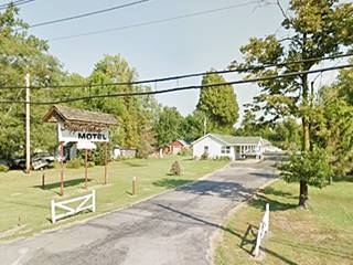
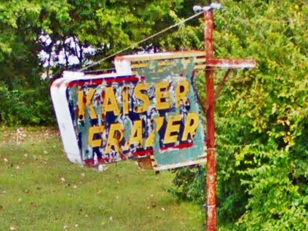
Drive 200 yards, and to your right is an old motel, in disrepair This motel had some dual cabins with gable roofs and was built around 1935 by Charles and Otto Baumann. The faded neon sign has peeled away to reveal that beneath the green paint it had been a "Kaiser-Frazer" neon sign. The sign was removed in October 2019 (stolen? sold?). Kaiser-Frazer Corporation was owned from 1947 to 1953 by Henry J. Kaiser and Joseph W. Frazer, they made cars.
Head west along Chain of Rocks Bridge (technically this area is part of Glen Carbon, and further west, of Pontoon Beach, but we include it in Mitchell because both towns are distant from the Mother Road, to the south).
Two towns by Route 66
Glen Carbon
The village incorporated in 1892 and adopted the name "Glen Carbon" (Valley of coal).
Pontoon Beach
This town incorporated in 1962 and took its name from a sandy beach on Long Lake.
Glen Carbon 1940s gas station
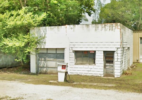
After 0.7 miles, at 5201 Chain of Rocks Rd. and Idle Acres Ln. To your right, on the north side of the highway is a 1940s concrete block service station. A simple office on the right with a sigle service bay with a multi-pane door. No canopy, only a vintage 1970s gas pump on a half-buried concrete pumps island.
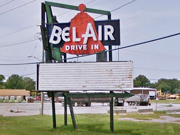
Bel Air Neon Sign (Gone)

Bel Air sign (2013). Click for large image
Drive west to visit a vanished landmark: the site of a now removed neon sign, it was located on the northeastern orner of IL-111 and Historic Route 66, at this spot Rittenhouse mentioned a cafe aand garage, both have also gone, this aerial photo frolm 1945 shows both buildings on the NW and NE corners of the intersection.
The Bel Air Drive In opened in 1953 and closed in 1987 it was razed in the 1990s and now an industrial park stands on the site.
Its classic neon sign was slowly falling apart, and is pictured below in 2017. The other image shows its other side, with the missing final "R".
It was removed in 2018 after being purchased by two sign collectors.
Apple Valley Motel sign
Head west along Route 66, and at 709 East Chain of Rocks Road, to your right is the sign of the Apple Valley Motel.
The motel dated back to 1949 and burned down in June 2016. The billboard with a shingle gable roof is all that remains (and the concrete foundations, futher back from the highway).
It had a linear layout, with gable roof and white woodframe structure. The eighteen units were perpendicular to the highway.
In its final days it offered long-term leasing.

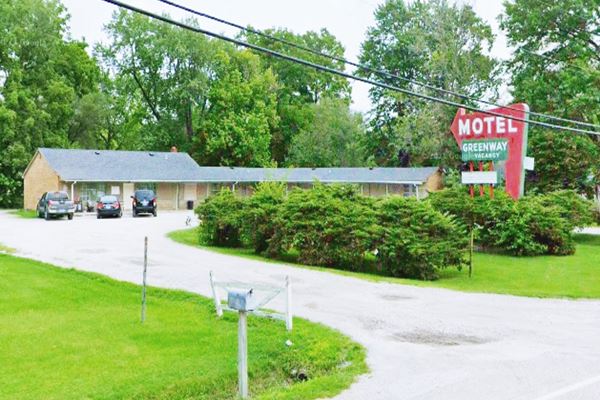
Greenway Motel

Greenway motel classic neon sign. Credits
Just ahead, at 701 E Chain of Rocks Rd, also to your right is the second motel in Mitchell, the Greenway.
It is a classic "V" shaped motel that dates back to the early 1950s (its northern wing appears in the 1955 aerial photos of this area).
In 2008, it was also operated by the same owners of the neighboring Apple Valley.
It has a memorable classic 1950s neon sign, with the eye-catching arrow enticing travellers to stop and check in.
Greenway Motel in Mitchell, Illinois
Red-Brick Route 66
Continue west into the "downtown" Mitchell.
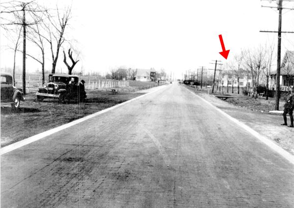
The photograph below, taken in 1933 shows the main local attraction, the Luna Cafe -red arrow, and also that at those days Route 66 was paved with bricks. You can see the 10-inch-wide concrete curbs on both sides of the highway.
Paving with bricks was a common practice in the early 20th century.
> Read more about Brick paved sections of Route 66.
This is the same spot nowadays, bricks removed.
Luna Cafe
Ahead, to your right at 201 E Chain of Rocks Rd is this Cafe that is almost 100-years-old.
The restaurant opened in 1924, two years before Route 66 was created. Al Capone is supposed to have stopped here when he visited the local gangsters.
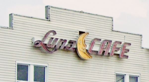
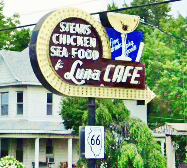
The name "Luna" is Spanish for "Moon". The moon is part of the sign on the building's facade. Its neon sign includes a curved arrow with a martini glass, olive and all!
Luna Cafe in Mitchell, Illinois
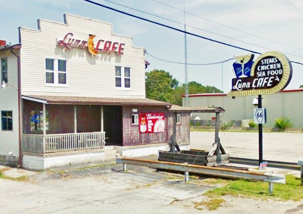
Detail of the smiling moon on the building's sign:
Close up view of the sign, with its martini glass and the "Fine drinks - pkg. goods" wording, also Steaks, chicken and sea food were available!:
Leaving Mitchell
Just ahead, the highway curves towards the left. But originally there was a fork here:
- Bypass US66 & BYP40 used to cross the railroad with a grade crossing here, and went westwards in a straight line, but now this link is cut. We describe the motels and gas stations along this alignment in our Northern Granite City Bypass 66 page. (map with directions to get there)
- Original Route 66 (1926-35) later City 66 (1935-54) turned left and headed down Nameoki Rd (now State Hwy 203) into Granite City
Indian Mounds
Listed in the National Register of Historic Places
The Native American people that lived in this area around 1200 AD built earth mounds. The most famous ones are next to the 1954 alignment of Route 66, the Cahokia Mounds in neighboring Collinsville). But, here they also built them at what is known as the "Mitchell Archaeological Site".
It was mostly destroyed when the Interstate I-270 was built across it. At one time a platform mounds and a village stood here.
See them in the 1955 map next to long lake, south of Route 66 as "Indian Mounds" (location map.)
Your Route 66 Road Trip through Mitchell ends here, head west to the historic Chain of Rocks bridge in Madison or go south into Granite City.

Sponsored Content
>> Book your Hotel in Chicago

Credits
Banner image: Hackberry General Store, Hackberry, Arizona by Perla Eichenblat
Place Names of Illinois, Edward Callary
J. Rittenhouse, 1946, A Guide Book to Highway 66


