Where Route 66 reaches the Mississippi River
Index to this page
All about Venice, Illinois
Trivia, Useful Information & Facts
Elevation: 420 ft (128 m). Population 1,446 (2024).
Time zone: Central (CST): UTC minus 6 hours. Summer (DST) CDT (UTC-5).
Venice is a city in Madison County, Illinois, United States on the 1926-40 alignment of US-66.
History of Venice
Humans have lived in Illinois since the retreat of the glaciers at the end of th last Ice Age some 12,000 years ago.
Read about the history of Madison County on our Mitchell IL webpage.
The city dates back to 1873 and was chartered in 1897 but it was named back in the 1840s by a Dr. Cornelius Campbell who lived across the Mississippi River in St. Louis and was a shareholder in the River ferry.
The first post office opened in 1838 and was named "Six Mile"; it was renamed Venice in 1843.
The Name:Venice
It was very likely named after Venice, in Italy. It is said that the first settlers called it "Venice" because when the river flooded every spring, the water rose and covered everything.
Venice (Venezia in Italian, from Latin Venetia) derives from the name of a Celtic tribe, the Veneti who were conquered by the Romans and lived in that part of northern Italy.
Your Hotel in Venice Illinois
Find your Hotel. Lodging & accommodation in Venice is rather limited, but you can find hotels in Granite City.
> > Book your hotel nearby in Granite City or East St. Louis
More Accommodation near Venice on Route 66
Below you will find a list of some of the towns along Route 66 east and west of this town; click on any of the links to find your accommodation in these towns (shown from east to west):
Along Route 66 in IL
- Hotels in Illinois
- Route 66 Starting point ▸ Chicago
- Lockport
- Willowbrook
- Bolingbrook
- Plainfield
- Romeoville
- Joliet
- Wilmington
- Dwight
- Pontiac
- Chenoa
- Normal
- Bloomington
- Atlanta
- Lincoln
- Springfield
- Raymond
- Litchfield
- Staunton
- Williamson
- Hamel
- Edwardsville
- Collinsville
- Troy
- Glen Carbon
- Pontoon Beach
- Granite City
- East St. Louis
West in Missouri
- Hotels in Missouri
- Florissant MO
- Bridgeton MO
- St. Louis MO
- Kirkwood MO
>> Check out the RV campground in neighboring Granite City
Weather in Venice Illinois
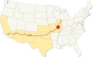
Location of Venice on U.S. Hwy. 66, Illinois
Average temperatures ranged from a low of 19 °F (−7 °C) in winter (Jan) to a high of 90 °F (32 °C) in summer (Jul). But record lows of −16 °F (−27 °C) and high of 114 °F (46 °C) have been recorded.
The average monthly rainfall ranged from 1.99 inches (51 mm) in January to 4.24 inches (108 mm) in May.
Tornado risk
Venice is in an area that is hit by about 7 tornados per year.
Tornado Risk: learn more about the Tornado Risk on US 66.
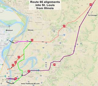
Map of Route 66 through Venice
Click on the Map to see a large sized map showing Route 66 alignments that go into St. Louis MO from Illinois.
This is the color key for this map is the following:
Orange: is first, it shows the original 1926-32 aligment of US66 through Madison and Venice into St. Louis MO.
Pink is the Bypass US-66 that crosses the Chain of Rocks Bridge in the north side of the neighboring city of Madison.
Green, and the other colors (Salmon and Yellow) show different courses taken by US 66 over the years.
Violet, the latest 1954 alignment from Hamel through Troy and Collinsville.
Black: missing segments that can no longer be driven.
Historic alignments through Venice
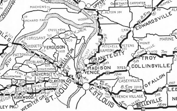
The following map was published in 1924 (two years before Route 66 was created) and shows the "auto trails" of that time, roads that could be "safely" driven in a car. The road marked "13" was the "Mississippi Valley Highway" and the one marked "66" was the "Mississippi River Scenic Highway". State Highway 4 shown as (4), all went through Madison and Venice-in the middle of the map, beneath Granite City.
1926-29 Route 66 crossing McKinley Bridge
In 1926 Route 66 was aligned along State Route 4 from Hamel to Venice, and entered the town along Broadway and crossed the Mississippi River on the McKinley Bridge. This is the Map of the 1926-29 US66 in Venice, that can be driven nowadays (in red in the map below -click on it to enlarge.)
Actually the original road ran straight west along Broadway, but this is now cut by the railroad -at that time a grade crossing- and Fourth St. So you have to turn north and then south along Cedar to reach the bridge. See this custom Map of the missing part of Route 66 along Broadway. Read more about Cut off section of US 66 further down.
1929-35 alignment South of Madison to the Municipal Bridge
In 1929 this changed and Route 66 took a southwards course through Venice, Brookyln and into East St. Louis, to cross the Mississippi along the "Municipal Bridge" on the south side of St. Louis. This alignment has some missing segments, so there are three maps to show it:
- Map 1 Madison to 10th St. in East St. Louis
- Map 2 E. St. Louis to Piggott Ave.
- Map 3, crossing Municipal Bridge (now closed to car traffic).
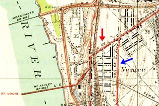
So the original 1926 alignment using McKinley Bridge became the Optional 66 highway. Both these alignments are shown in the USGS map published in 1935 (see above -click to enlarge): the red arrow shows Optional 66 and the Blue arrow marks the City 66.
The Route 66 alignment in Venice
Visit our pages with old maps and plenty of information about US 66's alignments.
- Route 66 St. Louis to Gray Summit (next)
- Route 66 Hamel IL to St. Louis MO (In Venice)
- Springfield to Hamel IL (1930-77 previous)
- Springfield to Staunton IL (1926-30 US66 previous)

Venice: its classic Route 66 Sights
Attractions & Landmarks
Safety Tip - Crime rate
As in East St. Louis and St. Louis, See the Route 66 sights during daytime and then move on to stay in accommodation outside the city. Both East St. Louis and St. Louis and some neighboring towns have a very high crime rate and travelers don't feel safe to spend the night here.
Drug abuse and crime rates are high. Keep off the streets at night. Know exactly where you are going. Don't get lost or end up in a bad neighborhood.
Where Route 66 First Crossed the Mississippi River
You will drive through Venice along the 1926 to 1940 US 66 alignment, the first to Cross the Mississippi River. The journey begins on the western side of the neighboring US 66 town of Madison, where Madison St. becomes Broadway.
It is a short 1.8 mile drive and not many landmarks have survived the ravages of time, economic downturn, and urban renovation.
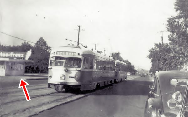
John's Drive In, old Tastee-Freez
417 Broadway, to your right. This place has been John's Drive In since 1977 a fast food, burger & shake place. But it has a long history: in the past it was a Tastee-Freez,
a franchise founded by Harry Axene and Leo Moranz in Joliet, Illinois in 1950. Famous for its soft ice cream.
Below is a picture of it, and a streetcar on Broadway, from the 1950s (red arrow.)
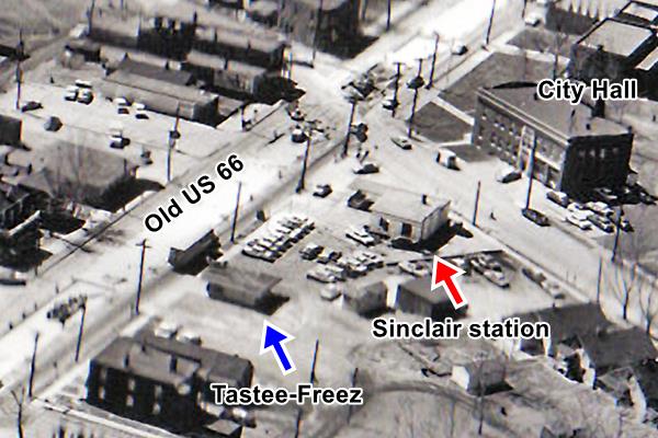
Ahead, in the adjacent property is a former Sinclair filling station, below you can see this station and the Tastee-Freez in an aerial photograph taken in 1960, looking towards the southwest:
Sponsored Content
Former Sinclair Gas Station
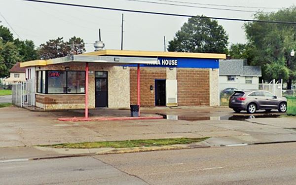
At 401 Broadway, Venice, on the NW corner of Broadway and Klein, to your right is the old Sinclair. It was a Shell back in the 1930s, later it was owned by Ervin Essenpreis. It has a flat roofed canopy over the pumps island -pumps gone- and the garage area has been enclosed and its multi-pane doors removed. Now it is a China House, a restaurant.
Former Gas Station in Venice, Illinois
Westwards to McKinley Bridge
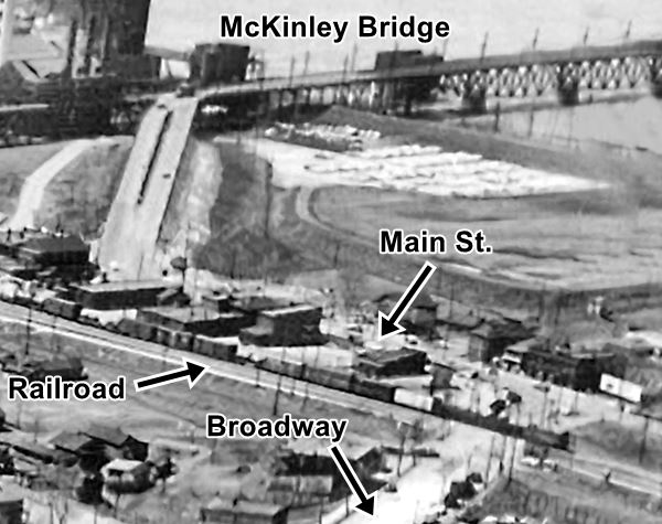
Broadway heads west towards McKinley Bridge, originally it crossed the railroad with a grade crossing and turned sharply left along Main Street and onto the bridge. The image below shows this part of Venice seen from the air in 1960:
Cut Off Section of US66
But this was modified in the late 1970s, a safer approach was built to carry state highway 3 and an underpass was built further north: Broadway curves north and its continuation is named 2nd St. The original Route 66 and Broadway was cut off from the new alignment. You can still see this old segment of the Old Route 66 just beyond the junction. Check it out in this map.
There were several gas stations and restaurants along Main Street at the foot of the bridge, all were razed: Hairston Service Station & Confectionery (901 Main),
Adam's Service Station selling Site Gas, a local St. Louis brand (904 Main), Phil's Eat Shop (820 Main) were some of them.
Then came the bridge.
McKinley Bridge
The McKinley Bridge was the first alignment of U.S. Route 66 across the Mississippi.
Crosses the Mississippi River from Venice, Illinois into St. Louis Missouri
McKinley Bridge in Venice, Illinois
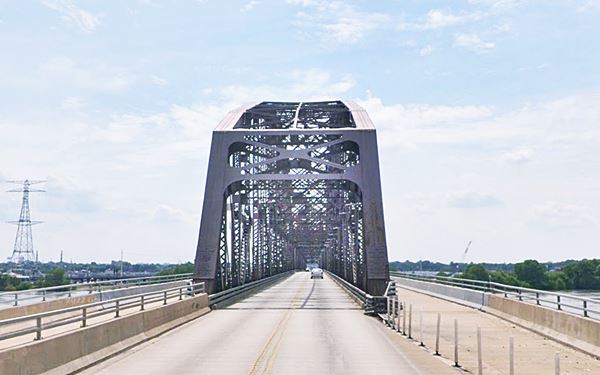
And, NO, it was not named for President William McKinley; instead it was named after William B. McKinley who was the CEO of the Illinois Traction System, an inter-city electric railway which reached St. Louis along this bridge.
It opened in 1910 and was closed in 2011, rehabilitated. and reopened again in 2007. The new bridge has the three original river truss spans whidh are 519 ft (158 m) long each. It also has 33 steel plate girder spans.
Its total length is 6,313 feet (1,924 m) and has a clearance below of 90 feet (27 m) above the mean water level.
Until 1978 it also carried a railroad line, new lanes were added when it closed.
This is the end of your road trip and city tour through Venice. Head west into St. Louis and continue your road trip in Missouri.

Sponsored Content
>> Book your Hotel in Chicago

Credits
Banner image: Hackberry General Store, Hackberry, Arizona by Perla Eichenblat
Route 66 in Madison County, Cheryl Eichar Jett. Madison Historical: The Online Encyclopedia and Digital Archive for Madison County, Illinois. 2019


