Bypass Route 66 in Bridgeton, Mo
Index to this page
- About Bridgeton
- Bridgeton's Weather
- Hotels and accommodation
- Map of US 66
- What to see and do in Bridgeton
About Bridgeton, Missouri
Facts, Trivia and useful information
Elevation: 584 ft (178 m). Population: 11,205 (2024).
The town of Bridgeton is part of Greater St. Louis, and is located in the northwestern part of St. Louis County, Missouri. Some portions of the Lambert-St. Louis International Airport are located within Bridgeton.
History
The first human beings arrived here at the end of the last Ice Age, 11,000 years ago. Later they modern Native Americans inhabited the riverine environment of the Missouri and Mississippi Rivers.
French trappers and explorers coming from Canada claimed the territory for their King, Louis XIV, and named it Louisiana after him. What is now Bridgeport was explored by Étienne de Veniard de Bourgmont in 1724.
St. Louis was founded in 1764, and in 1786 St. Germain surveyed the future site of Bridgeton. In 1794 it was platted as Marais des Liards (Cottonwood Swamp) by Maturin Bouvet.
A fort was built nearby to protect the local residents.
The Spanish governor of Louisiana granted Robert Owens, who had resided in the county since 1789, permission to found a town there (Spain had acquired Louisiana after a war with France), it was named Village à Robert (Robert's village) after its founder.
The French recovered the Territory in 1800, but cash-strapped Napoleon Bonaparte sold it to the U.S. in 1803. The name of the village changed to Owen's Station as more Americans moved to the area after 1803.
Meriwether Lewis (of the Lewis and Clark expedition) passed through Bridgeton during the famous expedition. The city was chartered in 1843 within St. Ferdinand Township.
The name: Bridgeton
Unknown origin. Bridgeton comes from Britain and combines the words "bridge" the site of a bridge or even a for across a stream and "tun" or "ton", Anglosaxon for farm or village.
Bridgeton Commons
The Spanish governor granted 1,000 acres to the town, as "commons" and this was ratified by an act of Congress in 1812.
Commons land is a piece of land collectively owned and set aside to benefit the local community used by farmers for grazing or gathering wood.
It is the only community in the United States that still has a commons.

Where to Lodge in Bridgeton, Missouri
Accommodation and hotels near Bridgeton
> > Book your accommodation in Bridgeton
More Lodging near Bridgeton along Route 66
There are several hotels in the area close to this town. Alternatively you can also find your accommodation along Route 66 in the neighboring towns and cities in Missouri. We list them below (from east to west):
On Route 66's Main alignment in MO
Eastwards
Westwards
- Hotels in Kansas
- Baxter Springs KS
- Galena KS
- Riverton KS
- Hotels in Oklahoma
- Miami OK
>> Check out the RV campground in neighboring St. Charles
Weather in Bridgeton
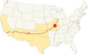
Location of Bridgeton on U.S. Hwy. 66
Rainfall in Bridgeton is around 41 in. (1.041 mm) each year. Snow falls from Nov. to Apr.: 17.8 in. (45 cm). It is a very humid area.
It has four well marked seasons and is located in the spot where humid continental climate shifts towards a humid subtropical climate. Therefore its summers are hot and humid and its winters are cold.
Spring is wet and may have extreme weather (tornados, thunderstorms, and even winter storms). Weather is mild during Fall, it is sunny and less damp.
The average winter high (Jan) is 39.9°F (4.4°C) and the lows average 23.7°F (-4.6°C). The summer (Jul) average high is 89.1°F (31.7°C) and the average low is 71°F (21.7°C).
Tornado risk
Bridgeton is inside Missouri's "Tornado Alley" and St. Louis County has around 7 tornados each year.
Tornado Risk: read more about Tornado Risk along U.S. 66.
Map of Route 66 in Bridgeton Missouri
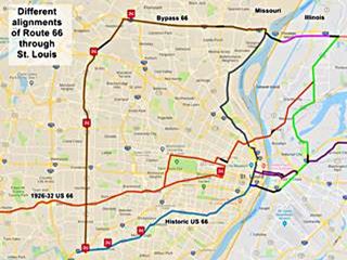
The map shows Route 66 in the St. Louis Region in both Missouri and Illinois. The color key for the map is:
Orange: is first, the original 1926-32 alignment of US66 through St. Louis
Brown is the Bypass US-66. Bridgeton is on the upper right side of the map.
Pale Blue: Is the Historic Route 66 alignment after 1932 into St. Louis, from the west. The gap in the alignment south of Crestwood MO is where I-40 overlaps the old alignment.
Blue, Green, Gray, Pink, Yellow, and Violet show different courses taken by US 66 over the years.
Black: missing segments (For instance, at the airport in Bridgeton).
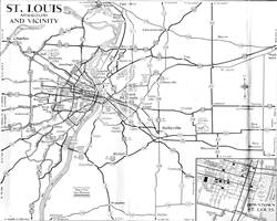
The following map published in 1955 shows Route 66 in St. Louis vicinity. Bridgeton is located by Alt 40 and Byp 40 next to the "Municipal" airport.
Bypass 66
Apart from the "City 66" which went through downtown St. Louis -hence its name- there was another branch that split from the main alignment on the north side of the city. It was known as "BYP 66" (Bypass 66).
On the western tip of the Chain of Rocks Bridge it took a sharp left, heading west, following what then was Hall Ave., and then further west it continued along Lindbergh Ave., nowadays Dunn Rd. on the north side of I-270.
At modern Exit 25 of I-270 the road curved south (now the ramp next to Pershall Rd.) heading straight south along N. Lindbergh Blvd.
Missing segment at the Airport

A 1953 Missouri DOT map with Bridgeton on NW St. Louis. Note the airport
At Bridgeton, this old road was cut in 2004 by the extension of St. Louis Lambert Airport runways as shown in custom map with a purple line. The modern highway curves west and passes under the runway.
The expansion of St. Louis Lambert International airport to build a new runway razed 2,000 homes in Carrollton and many U.S. 66 Bypass motels and landmarks were lost. The highway was cut by the new runway and realigned around the airport.
See this aerial photo from 1958 that shows the original alignment.
This is the Bypass 66 map in Bridgeton (after it was realigned around the airport).
South and west from Bridgeton
BYP 66 then continued straight southwards all the way to Watson Rd. on the southwest side of the city, where it met the "City 66" alignment, and both "City" and "Bypass" 66 merged back into US 66 and headed west, crossing the Meramec River.
Rittenhouse and his 1946 Book: US 66 in St. Louis
Jack DeVere Rittenhouse in his "A Guide Book to Highway 66", published in 1946 gives us a first hand account: He drove through Edwardsville and Mitchell, and wrote that just past Mitchell, "Here City Route 66 forks off to the left into Saint Louis, while the main US 66 crosses railroad tracks and continues ahead to the CHAIN OF ROCKS BIRDGE and the "belt line" route skirting the city..." in his day the toll was for auto and occupants: 25¢ This was the best route if you were not planningon stopping in St. Louis. He describes its loop around the city, passing near the Airport and "rejoin[ing] City 66 at a point 26 miles from Chain of Rocks Bridge" the road was "a wide, high-speed route" lacking city traffic and with many service stations and some cabins and cafes.
He tells those who chose City 66 that, after the center of the city it ran along Gravois Ave. Chippewa St. and Watson Ave. meeting the Bypass 66 13 miles from St. Louis City Hall.
Route 66 across Missouri
Historic U.S. highway 66, "Route 66" has been designated as an All-American Road and National Scenic Byway in the state of Missouri.
The Route 66 alignment in Bridgeton
Visit our pages with old maps and plenty of information about US 66's alignments.
- Gray Summit to Rolla (next)
- Route 66 St. Louis to Gray Summit (In Bridgeton)
- Route 66 Hamel IL to St. Louis MO (previous)
Route 66 Sights in Bridgeton
Landmarks and Places to See
Airway Drive In neon sign
Drive south along the old highway from Hazelwood (on the north side of the airport). Nothing remains of the old landmarks on this side of the airport so take the realigned highway to the southern side where some motels have survived, all the other hotels and motels were demolished when the airport's runway was lengthened.
Ahead is I-70; after crossing it, exit N Lindbergh to visit a classic neon sign. See this map with directions, it is 0.9 miles away along St. Charles Rock Rd.
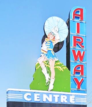
The site is located in the town of St. Ann. The old drive-in could accommodate 1,000 cars. It was torn down in 1996 but its neon sign was saved and now stands at the entrance to a local mall. It features a Majorette with a twirling baton.
Retrace your steps to Lindbergh and turn left, to head south; on the corner to your left is a Mall from the 1960s.
Northwest Plaza
When this shopping center opened in 1965 it was the largest mall in the world. Its construction razed the Route 66 Sunset Acres motel (at 3720 N. Lindbergh).
Ahead, to your right is another Route 66 motel:
Bestway Inn
At 3671 N. Lindbergh. Dating back to the 1960s it appears in a 1968 aerial photo. It is pictured below.
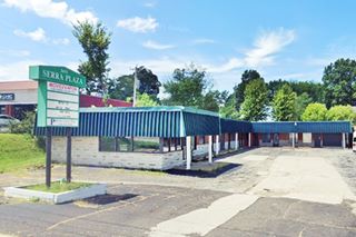
Next to it is another motel, the Capri.
Capri Motel
At 3651 N. Lindbergh, pictured above. It had an L-shaped layout and is now a small office and shops complex called "Sierra Plaza". It appears in a 1958 aerial photo.
Northwest Airport Inn
Ahead, to your left at 3570 N Lindbergh is another motel. Its matchbook mentioned "187 Suites, Banquet & Meeting Facilities". It has a 1960s look and is still there, as a long-stay apartment complex. It appears to have been built in the mid 1960s with the adjacent Northwest Plaza.
Congress Airport Inn
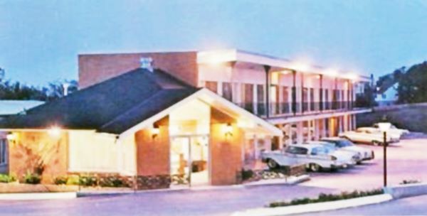
Head south and, to your right, at 3433 N Lindbergh Blvd. It opened as the Town House Motor Inn and its postcard proclaimed: "Near airport - courtesy car - wired music - T.V. - complimentary coffee and $5,000 Guest Life Insurance. Member - Network Inns of America."
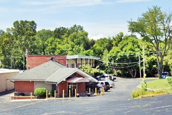
It is now the Congress Airport Inn and its appearance is unchanged as you can see in the "then and now" set of images below:
Town House Motor Inn postcard, Bridgeton MO
Same place nowadays:
Now the old motel is the Congress Airport Inn, Bridgeton MO
St. Ann
The town of St. Ann was born in 1940 as a defense housing project. It was built by Charles Vatterott who started with one-hundred homes and then added another 638 to the community. It was named after St. Ann, the mother of the Virgin Mary. It lies on the eastern side of Lindbergh adjacent to Bridgeton.
This is where your Route 66 Road Trip through Hazelwood ends. Continue west along Bypass 66 into the next town Maryland Heights.

Some sponsored content
> > Book your Hotel in Lebanon

Credits
Banner image: Hackberry General Store, Hackberry, Arizona by Perla Eichenblat


