The Granite Ware Industrial city
Index to this page
- About Granite City
- Weather
- Hotels in Granite City
- Map of US 66 in Granite City
- What to see and do in Granite City
All about Granite City, Illinois
Trivia, Useful Information & Facts
Elevation: 420 ft (130 m). Population 29,849 (2010).
Time zone: Central (CST): UTC minus 6 hours. Summer (DST) CDT (UTC-5).
Granite City is a city in Madison County, Illinois with two Route 66 alignments crossing it: the 1926-40 one and the 1940-54 one.
History of Granite City
Illinois has been inhabited since the retreat of the glaciers at the end of th last Ice Age some 12,000 years ago.
Check out our Mitchell page for the history of Madison County.
The Wiggins and Patrick Haniberry settled here in 1801 and they named the place the "Six Mile Settlement" as that was its distance from St. Louis.
Calvin Kinder arrived in 1817 and the first post office opened in 1838. The township was named Nameoki, the Indian name meaning "fishing place". When the Indianapolis & St. Louis Railroad" reached the area in 1854, they named their station Nameoki. But in 1856 renamed it "Kinder".
Many Germans settled in this area on both sides of the Mississippi, among them were Frederick and Mary Niedringhaus who arrived in the 1850s. Two of their sons, Frederick and William Niedringhaus founded Granite City in 1896.
The brothers had began business in St. Louis in 1866 and discovered and patented an enamel coating that protected the steel ware from rusting. It also allowed patterns to be embedded in them. The pattern resembled granite, so they named their invention "Granite ware". They became very popular across America.
They opened a steel mill on the land they bought in Illinois for their kitchen supplies factory, platted a town in which their employees were required to live in. The plant employed 4,000 workers and the town was owned by it so it didn't pay taxes to any of the surrounding cities.
In the 1950s stainless steel, pyrex glassware, and aluminum replaced enamel in kitchen ware.
The Name:Granite City
The area was originally known as Kinder (after Calvin Kinder) and changed to Granite City in honor of the Graniteware that had made it great.
Reaching Granite City
Drive into Granite City along Historic U.S. 66. You can also use the freeways that lead to St. Louis: I-55, I-64, I-70, and also Historic US-40.

Granite City, its Hotels and Motels
Lodging & accommodation in Granite City
> > Book your hotel in Granite City
More Accommodation near Granite City on Route 66
Below you will find a list of some of the towns along Route 66 east and west of this town; click on any of the links to find your accommodation in these towns (shown from east to west):
Along Route 66 in IL
- Hotels in Illinois
- Route 66 Starting point ▸ Chicago
- Lockport
- Willowbrook
- Bolingbrook
- Plainfield
- Romeoville
- Joliet
- Wilmington
- Dwight
- Pontiac
- Chenoa
- Normal
- Bloomington
- Atlanta
- Lincoln
- Springfield
- Raymond
- Litchfield
- Staunton
- Williamson
- Hamel
- Edwardsville
- Collinsville
- Troy
- Glen Carbon
- Pontoon Beach
- Granite City
- East St. Louis
West in Missouri
- Hotels in Missouri
- Florissant MO
- Bridgeton MO
- St. Louis MO
- Kirkwood MO
>> Check out the RV campground in Granite City
Granite City's weather
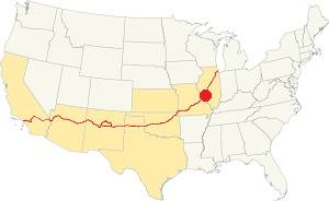
Location of Granite City on U.S. Hwy. 66, Illinois
Granite City is located in the area where humid continental climate shifts towards a humid subtropical climate. It has hot and wet summers, and cold winters: well marked seasons. It receives cold Arctic air and hot humid tropical air from the Gulf of Mexico. Spring is wet and may also experience extreme weather (tornados, thunderstorms and even winter storms). Fall is sunny, mild and less humid.
The average high in winter (Jan) is a cool 39.9°F (4.4°C) while the average low is a chilly 23.7°F (-4.6°C). The summer (Jul) average high is 89.1°F (31.7°C) and the average low is 71°F (21.7°C).
Rain averages 41 in. (1.041 mm) yearly. The wetest months are May through July with more than 4.1 in. per month (104 mm). Snow falls between Nov. and Apr., with a total snowfall of 17.8 in. (45 cm).
Tornado risk
Granite City is in an area that is struck by some 7 tornados every year. Tornado Risk: learn more about the Tornado Risk on US 66.
Map of Route 66 through Granite City
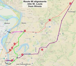
Click on the Map to see a large sized map showing Route 66 alignments that go into St. Louis MO from Illinois.
Three different alignments of US 66 run through Granite City, one, marked in orange in the map (click on it to enlarge) is the original 1926 alignment; the second, in green, is the later "US 66 City" alignment established after 1940, and the final alignment runs along the northern part of the city, far from its downtown area: the Main or Bypass 66 from 1930 to 1962.
Color key for this map is the following:
Green from Mitchell to Granite City, followed by Orange: is first, it shows the original 1926-32 aligment of US66 through Granite City, into Madison, Venice, and St. Louis MO (from Edwardsville -salmon color).
Pink is the Bypass US-66 that crosses the Chain of Rocks Bridge on the north side of Granite City and the neighboring city of Madison.
Green east of Granite City is the "second City 66 alignment". In Yellow is another alignment taken by US 66 over the years.
Violet, the latest 1954 alignment from Hamel through Troy and Collinsville.
Black: missing segments that can no longer be driven.
Historic alignments through Granite City
Before Route 66 existed (1924)
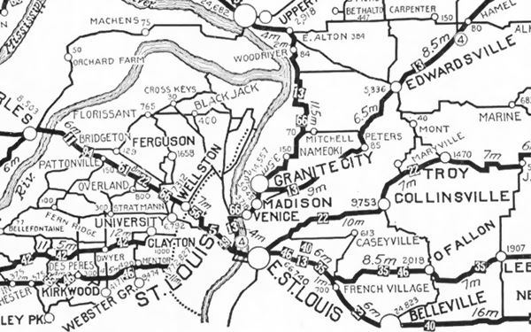
The following map was published in 1924 (two years before Route 66 was created) and shows the "auto trails" of that time, roads that could be "safely" driven in a car.
The road marked "13" was the "Mississippi Valley Highway" and the one marked "66" had nothing to do with the future Route 66; it was the "Mississippi River Scenic Highway".
State Highway 4 shown as (4) would become Route 66. It came from Edwardsville, through Mitchell and reached Granite City.
1926-1940Route 66: Mitchell to Granite City
Coming from Hamel and Edwardsville, at Mitchell it curved with a NE SW course along Nameoki Rd into Granite City, see this Map with directions of the 1926 alignment through Granite City (6.2 miles long).
The highway followed what is now MO-203 (Nameoki Rd.), turning south along the western side of Granite City along Edwardsville Rd.
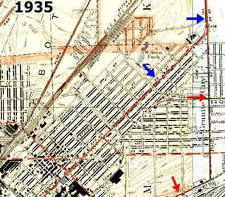
It is marked with blue arrows in the thumbnail map (click to enlarge), and with a green line in the map further up. At Madison Avenue it turned southwest going through Granite City proper and then continuing along Madison Ave. into Madison (See orange line in the larger map further up).
Second City 66
When the Chain of Rocks bridge opened in 1930, the original alignment through Granite City was renamed City 66, and called "second" to differentiate it from the one on the western side of the Mississippi that was St. Louis' City 66.
This took place around 1935 and ran through Granite City, Madison and Venice (Map with directions).
But by 1940 it had been realigned on the eastern side of both Granite City and Madison: the red arrows show the later "1935-54 City 66" alignment.
City 66 ran with Alt US 67 (now IL-203) all the way to Collinsville Rd. to cross the Mississippi in East St. Louis.
Main 66 or Bypass 66
A new segment of Route 66 known as "Main 66" or "Bypass 66" was built west of Mitchell and through the a place called St. Thomas on the northern part of Granite City.
This segment existed from 1935 to around 1962. It continued across Madison City's northern side on Chouteau Island to the Chain of Rocks Bridge and crossed the Mississippi into St. Louis MO.
See its alignment, now cut by I-270, in this map (Thorngate Rd) and, west of the freeway Bypass 66 map (Chain of Rocks Rd).
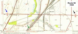
The USGS map published in 1948 below (click on it to enlarge) shows Route 66 reaching Mitchell (black arrow), City 66 heading south into Granite City (green arrow) and Route 66 heading west towards the Chain of Rocks bridge (blue arrow).
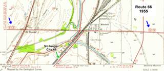
In the second map, published in 1955, It is BYP 66 that enters and exits Mitchell (blue arrows), the old City 66 had been eliminated becoming State Hwy 3 and Main 66 ran far to the east and south through Collinsville.
The Route 66 alignment in Granite City
Visit our pages with old maps and plenty of information about US 66's alignments.
- Route 66 St. Louis to Gray Summit (next)
- Route 66 Hamel IL to St. Louis MO (In Granite City)
- Springfield to Hamel IL (1930-77 previous)
- Springfield to Staunton IL (1926-30 US66 previous)
Granite City: its classic Route 66 Sights
Landmarks and Places to See
Sponsored Content
Attractions & Landmarks
Heading west from neighboring Mitchell, Route 66 originally curved south, following the railroad, and ran next to it as Nameoki Rd. this was the original 1926 US 66 alignment into Granite City. In 1929 the Chain of Rocks Bridge was opened to traffic and the road that linked it with Mitchell was paved to carry US 66, bypassing Granite City, Madison, and Venice, but as the Missouri side of the bridge wasn't yet ready Route 66 only moved to Chain of Rocks in the mid 1930s. This alignment was known as "Main 66" or "Bypass 66" and the old one became "Second City 66" (the "first" one was the one through St. Louis MO).
Below we describe the "original US66" and the later "Second City 66" alignments, and further down the Bypass 66 attractions.
Sights along the Original US66 - Second City 66
Not many Route 66 attractions and landmarks have managed to survive along these two segments. Most have been lost to development or torn down, especially on the eastern side of town.
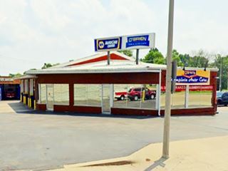
O'Brien Tire & Auto Care
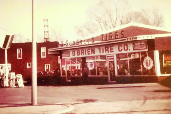
Drive into Granite City from Mitchell along Nameoki Road; originally it had two lanes, but in the early 1970s it was widened to a divided highway with 2 lanes in each direction. It turns south as it enters Granite City and just beyond the overpass, to your left at 3924 Nameoki Rd. is a classic garage:
The Klug brothers opened their service station and garage in the 1920s and sold it to James O'Brien on St. Patrick's Day in 1932. It has changed owners since, but
it has always offered the "Best Fix on Route 66".
Its main attraction is the 12-foot high, 8,000 pound (4 m, 3200 kg) giant tire next to its southern facade.
Continue straight and take a right along Madison Ave. this is the original alignment of Route 66 through the city.
Mr. Twist Ice Cream
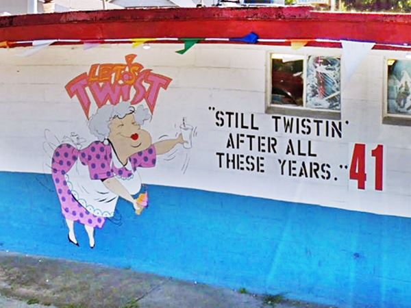
At 2649 Madison Ave, to your right, on the corner is this family owned shop offering the "Best Ice Cream and Sherbet in Granite city" the same owners haver ran it over the past 45 years, but it is at least 67 years old, because the building appears in this 1955 aerial photograph.
Old Gas Station
After passing the Police station and the Fire Dept., to your right, on the corner at 2301 Madison Ave is an old gas station.
It is a 1940s gas station; its canopy was originally flat, but has been changed to a gabled roof over the pumps island. The pumps are gone. The office on the corner has two service bays to the right and one along 23rd Street.
Old Gas Station in Granite City, Illinois
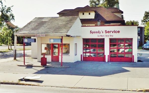
Head west along Madison (Route 66) and then visit some downtown sights by taking a right along Niedringhaus Ave. Then as you turn left onto State St, to your right is a 1940s gas station, flat roofed with an angled corner office and two service bays (street view).
Labor Temple Neon Sign
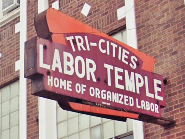
On the following corner, to your left at 2014 State St. is the United Steelworkers building with the "Tri-Cities Labor Temple Home of Organized Labor" classic neon sign over the entrance entrance.
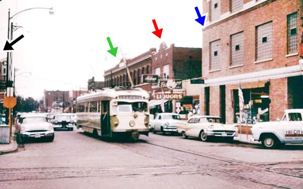
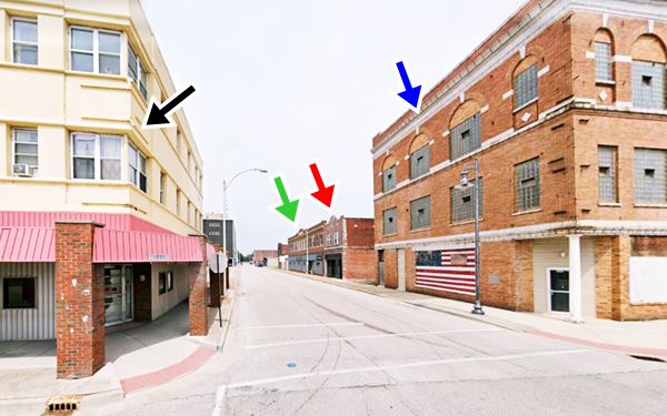
Head west one block to 19th St. there are many vacant lots, and many of the red-brick buildings are gone. The urban scenery has changed significantly, but some traces of the past remain: the green, red, and blue arrows mark the same buildings in the "Then and Now" sequence of pictures below. Unfortunately the Granite City to St. Louis street car service was discontinued in 1958.
Street scene 1950s postcard in Granite City, Illinois
Same spot today.
Street scene nowadays in Granite City, Illinois
Granite City "It's Electric Neon Sign Park"
On the corner of Delmar and 19th St. there are several neon signs from the 1950s, 60s, and 70s that have been brought back to life at the city’s new neon sign park. Each sign, the Hudson Jewelers, Reese Drug Store, and Washington Theatre, belonged to well-known businesses in the city and date back to the early 20th century- you can read a brief history of each business on the plaques at their base. There is a mural too. It is part of the Route 66 Centennial celebrations (1926-2026)

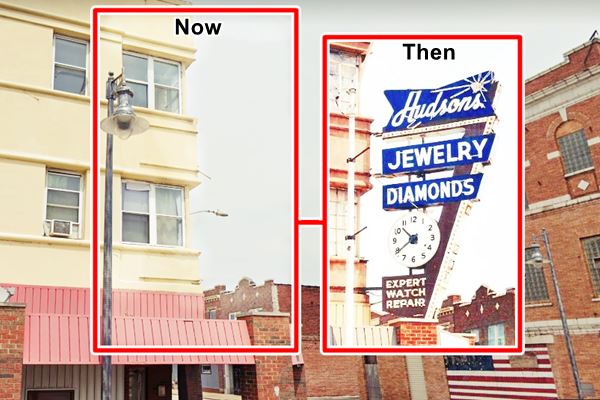
Site of Hudsons Jewelry Neon Sign
The black arrow in both of the images above shows the spot where Hudson's Jewelry Neon sign stood, on the corner at their downtown shop. But both shop and sign are gone. Levy & Co. Hudson's is still in business at another site. The sign was restored and can be seen nearby at the Neon Park.
Visit some of the original Granite City blue collar workers' homes, built in the 1890s by the company that employed them on Benton St. between 21st and 22nd Streets. This is a Street view of them.
This is the Map with directions of your Granite City "downtown" tour.
Continuing your Road Trip
From this point you have three options to continue your road trip:
- Return to Madison Ave (US 66) and continue west into Madison and Venice along original 1926 66 and first alignment of the 1930s City 66. See this map.
- Drive along the later City 66 (1935-54) through Fairmont City and East St. Louis (map)
- Take the Bypass 66 alignment from Mitchell through northern Granite City to the Chain of Rocks Bridge. We describe this option below.
Northern Granite City Bypass 66
From Mitchell towards Chain of Rocks Bridge
Head north (Map with directions); it is a 5.5 mile drive from downtown Granite City to BYP 66.
Drive to Route 66 in northern Granite City, the eastern segment along Thorngate Rd. begins on the city limits of Mitchell, and is currently cut off at both ends: To the east it is cut by the eliminated grade crossing that in the past carried Route 66 across the tracks of the St Louis and Alton Wabash Railroad and the Cleveland, Cincinnati, Chicago and St. Louis Railroad (in the 1940s). To the west it is now cut by the freeway I-270. This segment is shown with a yellow line in this map.
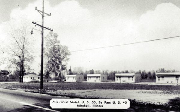
Midwest Motel
There is a lonely motel at 912 Thorngate Rd. This was a very busy road in the past but now it is completely cut off from the Chain of Rocks Road sandwiched between the railway to the east and the freeway to the west.
Originally it had four detached cabin-like dual units, with 8 rooms, typical of the 1930s and 1940s. Now they have been linked into one long single-floor linear layout, filling the gaps between the old units with newer ones and it has 14 rooms as you can see in the color current view.
This hotel was built between 1945 and 1955 as it appears in this aerial photo from 1955, but not in one from 1945. By 1968 the units had already been linked up.
St. Thomas
Turn around, go under the freeway and turn right along W. Chain of Rocks Rd. heading west, after the curve, it becomes the old straight alignment of US 66. Ahead, in the "hamlet" of St. Thomas that formed at the intersection of US 66 with ALT 67; the latter was decommissioned in 1964 and ran down what is now St. Thomas Rd.
There was traffic here at that time, at US BYP 66 and US BYP 40 crossing US Alt 67 (the freeway (IL-3) didn't exist in those days), and motels popped up to accommodate those driving along the highways.
Land of Lincoln, now Budget Motel
To your right, at 3220 W Chain of Rocks Rd. This motel was built in the early 1960s, it has a gabled portico and a modern '60s look to it. The neon sign with a map of Illinois has vanished.

Land of Lincoln Motel 1960s. US66 St. Thomas. Credits
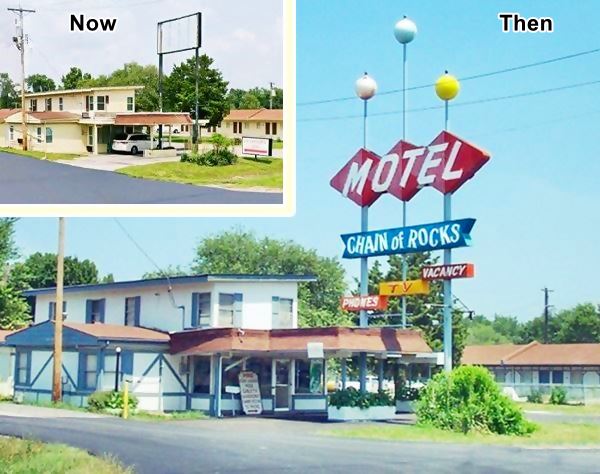
Chain of Rocks Motel
Next door is the former "Chain of Rocks Motel", it became the now closed Economy Inn, at 3228 W Chain of Rocks Rd. It has two parallel wings, the one on the right (east) was built in the early 1980s, the one on the right (L-shaped) dates back to 1955 (it appears in an aerial photo taken then).
Its great vintage neon sign was replaced in 2006 by the current bland-modern one. The original sign wasa sold to a private collector, a greaat loss for Route 66's history.
Below is a "Then and Now" composite image. The motel announced on its matchbooks: "Air conditioned TV Phones Pool Official AAA" and located at "Interstate 270 & State Hiway 3."
The neon sign standing and gone. Same view over the course of the years.
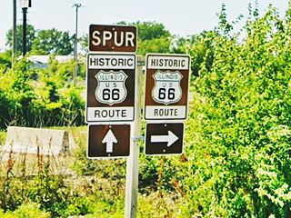
The adjacent Econolodge is modern. Ahead, to your right are some Historic US 66 signs -pictured below. They inform that the "Spur" Historic US 66 heads straight to a dead end at the Chain of Rocks Bridge and you can also take a right to continue along Historic Route 66 (via I-270 into Missouri and Bypass 66 there).
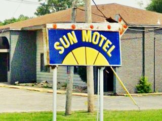
Sun Motel
To your left, across from the historic signage at 3241 W Chain of Rocks Rd. Pictured above. This motel has an "L" shaped layout in two separate gable roofed wings. It has been here since 1955 at least.
Canal Motel
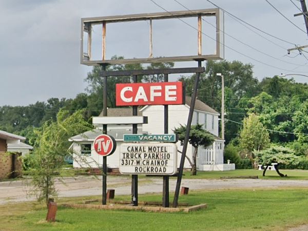
Located at 3317 W Chain Of Rocks Rd, the Canal Motel & Restaurant to your left is still standing. Its original neon sign is partly there having lost several parts over the years. The postcard shows it had a yellow arrow and the word "Canal" on the top of the sign. The arrow has been altered, the word "Canal" has gone, and the white box with the word Motel has also vanished in the mid 2010s. Its architecture is and the aerial photos show it was built in the late 1950s to early 60s.
The Canal motel's neon sign is slowly decaying. Below is a view in 2021:
Below is a "Now & Then" sequence of images:
Vintage postcard Canal Motel in Mitchell, Illinois
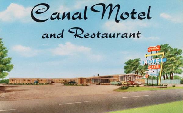
Former Canal Motel in 2013; the sign still had the word "motel".

Twin Oaks Gas for Less

Buckled Twin Oaks neon sign. US66 Granite City. Credits
To your left, after the motel are the ruins of a vacant old oblong-box gas station with a single service bay (street view). It had a great neon sign "Twin Oaks - Gas for Less" that blew down in a storm in 2006. The image shows it in its buckled state after the storm.
Your Route 66 Road Trip through Granite City ends here, ahead after crossing Chouteau Canal, is the historic Chain of Rocks bridge in Madison. The bridge spans the Mississippi River but it is a dead end as the bridge is closed for cars. However you can walk along it for some great pictures and views of the river.
Read about the Historic Chain of Rocks Bridge in our Madison webpage.
The Chain of Rocks Bridge
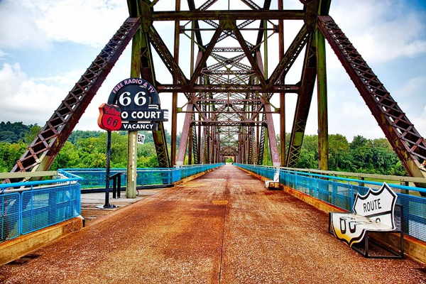
To continue your journey westwards into Missouri, head back to State Highway 3 and cross the Mississippi along I-270 (map with directions). You can drive into St. Louis along the City 66 alignment in Missouri: City 66 from Chain of Rocks to downtown St Louis.
Alternatively you can take the Bypass 66 in Missouri and circle around St. Louis, the first towns on that alignment are Florissant and Hazelwood.
Parks, Outdoors and Tours
Lewis & Clark State Historic Site
Just 3.9 miles north of Bypass 66 (map with directions). This Interpretive Center (more at their website campdubois.com) is located at the site of the Lewis and Clark expedition's winter camp. Here their trip was planned and organized.
There is a replica of the expedition's boat and the camp. Open Wed. through Sun. 9 am to 5 pm.
Meriwether Lewis and William Clark with 45 men of Corps of Discovery departed from Camp Dubois on May 14, 1804, and following President Jefferson's orders Lewis and Clark opened a transcontinental route.
They went up the Missouri River, crossed the Rocky Mountains, and from the Columbia River, reached the Pacific Ocean by November 1805. They were back in St. Louis in September 1806.

Sponsored Content
>> Book your Hotel in Chicago

Credits
Banner image: Hackberry General Store, Hackberry, Arizona by Perla Eichenblat


