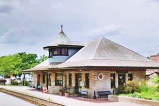
Route 66 in Kirkwood, Mo
Index to this page
- About Kirkwood
- Kirkwood's Weather
- Hotels and accommodation
- Map of US 66
- What to see and do in Kirkwood
About Kirkwood, Missouri
Facts, Trivia and useful information
Elevation: 659 ft (201 m). Population 27,807 (est. 2019).
Time zone: Central (CST): UTC minus 6 hours. Summer (DST) CDT (UTC-5).
Kirkwood is a town in St. Louis County, eastern Missouri.
History
This area has been inhabited for over ten thousand years. The French arrived in the mid 1700s from Canada, trading European goods for furs with the Osage and Kickapoo natives. The region was named Louisiana after the French King Louis XIV and St. Louis was founded in 1764.
The U.S. purchased it from France in 1803 and incorporated the Missouri Territory in 1812. In 1821 it became a state of the Union.
The old native trails (known as traces) became dirt roads and a stage coach route was establised along the road linking St. Louis with the state capital in Jefferson City. It was named Manchester Road and became US 66 in 1926.
Kirkwood was settled in the early 1850s in the eastern part of Bonhomme Township in St. Louis County, and the town was established in 1853 when the Kirkwood Association purchased 240 acres of land and platted a residential community on the Pacific Railroad that was being built through the area. It became the first suburb west of the Mississippi, linked by rail with St. Louis.
The name: Kirkwood
It was named for James Pugh Kirkwood, who was the first chief engineer of the Missouri Pacific Railroad. His surname has a Scottish origin and means "the wood near the church."
Route 66 Trivia
It has the rare honor of having three different Route 66 alignments running through it:
- The first one, from 1926 to 1932 along Manchester Rd.
- The later one, after 1932 and until the road was decertified, along its southern edge (Route 66 and City 66)
- Route 66 Bypass, with a north to south alignment along Kirkwood Rd. (which becomes Lindbergh Blvd.)
Getting to Kirkwood
Reach Kirkwood driving the historic Route 66 via Watson Rd. or Manchester Rd, or use Interstate I-44. I-270, US 50, US 61, I-55, and I-64 cross the area.

Where to Lodge in Kirkwood, Missouri
Accommodation and hotels close to Kirkwood
> > Book your accommodation in Kirkwood
More Lodging close to Kirkwood along Route 66
There are several hotels in the area close to this town. Alternatively you can also find your accommodation along Route 66 in the neighboring towns and cities in Missouri. We list them below (from east to west):
On Route 66's Main alignment in MO
Eastwards
Westwards
- Hotels in Kansas
- Baxter Springs KS
- Galena KS
- Riverton KS
- Hotels in Oklahoma
- Miami OK
>> Check out the RV campground in neighboring Fenton
Weather in Kirkwood
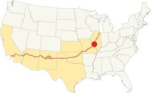
Location of Kirkwood on U.S. Hwy. 66
Rainfall in Kirkwood is, on average, 41 in. (1.041 mm). The most rainy months are from May through July with more than 4.1 in per month (104 mm). Snow falls from Nov. to Apr.: 17.8 in. (45 cm). The town has four well marked seasons. It is located in the area where humid continental climate shifts towards a humid subtropical climate, so summers are hot and humid while winters are cold. It gets cold Arctic air and hot damp tropical air from the Gulf of Mexico. Spring is wet and may have extreme weather (tornados, thunderstorms and even winter storms). Fall is sunny and less humid, with mild weather.
The average winter high (Jan) is a chilly 39.9°F (4.4°C) and the winter low is on average 23.7°F (-4.6°C). The summer (Jul) average high is 89.1°F (31.7°C) and the average low is 71°F (21.7°C).
Tornado risk
Kirkwood is inside Missouri's "Tornado Alley" and St. Louis County has around 7 tornados each year.
Tornado Risk: read more about Tornado Risk along U.S. 66.
Map of Route 66 in Kirkwood Missouri
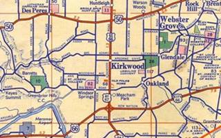
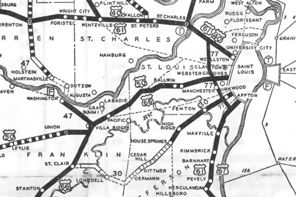
The thumbnail map below (click on it to see full size map) shows US 50, running from left to right on the north side of Kirkwood, US 66, bypass 67 and 61 running top to bottom through Kirkwood, and on the bottom of the map, Route 66 heading west (lower left) and into St. Louis as City 66 (lower right).
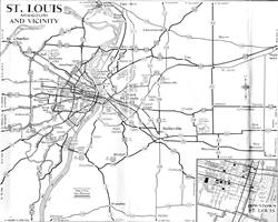
Above is another map, from 1955 showing all the roads leading into St. Louis (note US 66 and City 66).
The first Route 66 ran along Manchester Rd. with US 50, from 1926 to 1932. Then it was realigned south of Kirkwood (US 66 and City 66 in the map). The 1940s bypass 66 was built around St. Louis and it also went through Kirkwood.
Map 1931 showing the original US66 into St. Louis (Kirkwood middle right side of map)
See this map with US66 1926-32 alignment in Kirkwood, and this is the Bypass 66 map.
The Route 66 alignment in Kirkwood
Visit our pages with old maps and plenty of information about US 66's alignments.
- Gray Summit to Rolla (next)
- Route 66 St. Louis to Gray Summit (In Kirkwood)
- Route 66 Hamel IL to St. Louis MO (previous)
Route 66 Sights in Kirkwood
Attractions and Landmarks for your Road Trip
Start your tour of Kirkwood on the south side of town, where the 1932-1970s U.S. 66 (now MO-366) running along Watson Rd. meets S Kirkwood Rd. in Sunset Hills.
Here is where Bypass 66 and City 66 forked at the now gone "cloverleaf". Head north towards Kirkwood along South Kirkwood Rd.
Route 66 meets US Highway 61 "The Blues Highway"

The Mother Road meets the Blues Highway
Kirkwood Rd. carried US 66, bypass 67 (now US 67) and US 61 (which still runs along it).
US Highway 61 was created together with US 66 in 1926; it runs between New Orleans, Louisiana and ends in the town of Wyoming, Minnesota.
US Hwy 66 is known as the "Great River Road" because it runs parallel to the Mississippi for 1,407 miles, but it is best known as "The Blues Highway"
because it is linked deeply with the long history of blues music.
Bloody 66: "The Racetrack of Death"
What would later become Bypass 66 was dedicated as Lindbergh Boulevard on Dec. 13, 1930 shortly after it had been paved with concrete. The new name replaced the original one (Denny Road) but, in Kirkwood, Lindbergh was renamed Kirkwood Rd.
In the 1960s County coroner Raymond Harris named it "The Racetrack of Death" because over 20% of St. Louis County car accidents happened along Lindbergh. The carnage claimed, according to the St Louis Globe-Democrat (Oct. 1969), 800 people were injured and 22 killed during period of one year and a half.
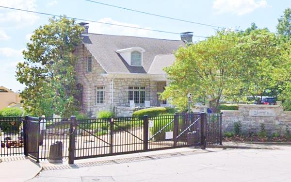
Green Parrot Inn
Listed on the National Register of Historic Places
Take a left along West Big Bend Road to 1500 W Big Bend Rd. (see this map with directions), after 1.4 miles you will reach a historical icon:
This was a classic restaurant built in 1915 by William Bopp and the postcard pictured below describes it as follows: "We specialize in Fried Chicken Dinners Open Year-Around Mr. and Mrs. J. H. Toothman, Proprietors."
Postcard of the Old Green Parrot, Kirkwood MO

Osage Movie Theater
Retrace your steps and continue north along former BYP 66 and you will reach downtown Kirkwood just south of the railway, with several landmarks.
At 338 S Kirkwood is the old Movie Theater:
The Osage Theater opened in 1932 with a capacity of 642 spectators. In 1968 it became Kirkwood Cinema. It closed in 1998 and was repurposed as offices and apartments.
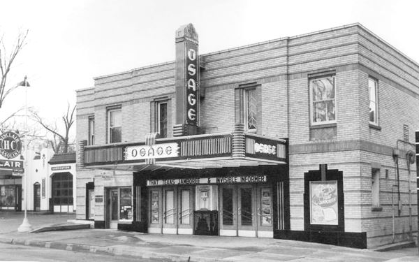
Old Gas stations
Lost stations: Sinclair and Phillips 66
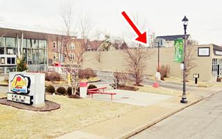
There was a Sinclair station on the SE corner of Kirkwood Ave and Kirkwood Pl. (pictured above - left side of the theater) and a Phillips 66 stood at 311 S Kirkwood Rd. (to your left) where Andy's Frozen Custard is now located. The Then and now sequence below shows the same wall on the north side of the property (red arrow):

1940s view Phillips 66 station Kirkwood MO. Source
Former Barbeau's Conoco station
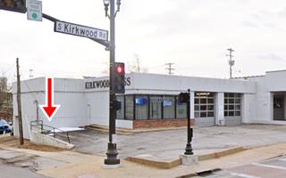
Across the street, to your right on the SE corner of S Kirkwood and E. Monroe once stood a Conoco gas station. It has been modified, but you can still make out the two former service bays and the steel railing on the north side of the property (red arrow in the images).
Facing it, on the NE corner was the Kirkwood Tire and Shell gas station, replaced by a modern three-floor apartments and commercial building that occupies the whole block along Route 66.

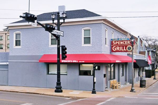
Spencer's Grill

1930s view Spencer's Grill. Source
On the opposite corner, to your left, at 223 S Kirkwood Rd. is a vintage restaurant. Don't miss its classic neon sign.
Spencer's Grill opened in 1947. Try its breakfast pancakes and omelets (and hamburgers too).
The "Then and Now" images show that it hasn't changed at all!
Spencer's Grill with its good food and neon sign, Kirkwood MO
Railroad Depot Area
Head north, and after passing by the City Hall, cross the railroad and take a right from Route 66 along E Argonne Dr. just ahead is a modern work of art, the "Chairs":
Three Stacked Chairs
On the boulevard's median, at E. Argonne Dr. 107 on the north side of the street, to your left.
The "3 Stacked Chairs" is the creation of artist Brother Mel Meyer, S.M., 1996, it was dedicated in the median of Argonne Drive in 2007. Turn around and head west. Cross Route 66. To your left is the historic railroad depot.
Railroad Depot
Listed on the National Register of Historic Places
The first train station was built in 1853. The present building was erected in 1893 by local constuctor Douglas donavan. Train Station: Kirkwood's historic Train Station was built in 1893 and is one of the City's most enduring and beloved buildings.
Coulter Feed
Listed on the National Register of Historic Places
Facing the station, to your right at 111 W Argonne Dr. Built in 1912 to house Joseph Coulter's feed store business. Coulter was a local Alderman in the 1920s.
The red brick building has white letters on it proclaiming "Hay Grain Flour & Feed Mills (pictured above).
Old Cottage-style Gas station
Listed on the National Register of Historic Places
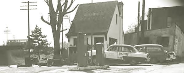
Ahead at 140 W Argonne Dr. to your left, hidden is the old gas station built in 1932 by DeRoo Weber. It is a small cottage styled station. Lately it was a custard stand and now Clementine's Naughty & Nice Creamery .
Below is a vintage photo, when it was a gas station:
Return to Route 66 and turn left, head north. Just before you reach Manchester Rd., to your right is an old auto dealership:
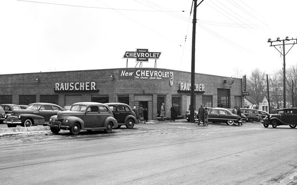
Rauscher Dealership
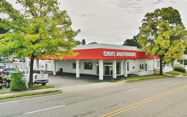
Cap Rauscher started the dealership in 1933 on N. Clay and W Jefferson, next to the now gone theater. In 1947 he moved to 1000 N. Kirkwood. Their slogan was "Save Bucks on Trucks."
His son, Les took over from him and in 1981 it became Chris Auffenberg Chevrolet. Below is a "Then and Now" sequence:
Route 66 crosses the 1926-32 Route 66 alignment
At Manchester Rd. the old Bypass 66 (that later became "Main US66") running north to south along Kirkwood Rd. crosses the original 1926 to 1932 alignment running east to west from St. Louis to Gray Summit.
Below is a 1950s photo; at that time US 50 ran along Manchester Rd. while US 66, 61 and Bypass 66 ran along Kirkwood Rd.
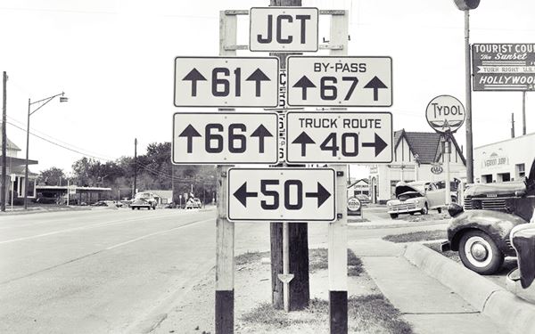
The image above shows a sign directing travelers to the now gone Hollywood Court (10336 Manchester Rd.) and Sunset Court (10521 Manchester Rd). The Tydol station has also been razed, but further ahead, at the junction, an old building has survived:
Doerflinger Realty
On the small triangle (SE side of the junction) between Manchester Rd, Kirkwood Rd. and the lane linking nortbound traffic along Kirkwood with eastbound lanes on Manchester, is a small gable roofed building that was formerly known as Doerflinger Realty and now is a pet grooming shop (Little House of Dogs). Below are two "Then and Now" pictures of the spot, the red arrows mark the building. Notice the modern signage marking Route 66.
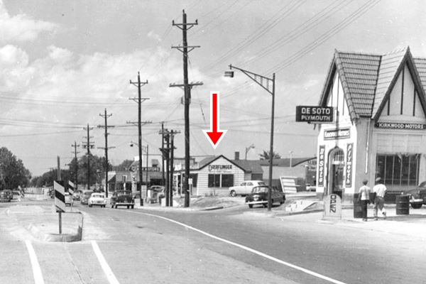
The De Soto dealership has gone.

Take a right along Manchester Rd (MO-100), and just ahead, to your left is a classic service station:
Trog's Service Station
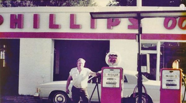
At 10456 Manchester Rd, now closed, it was a classic gas station on Manchester Road, US 50 at that time. It was built in 1937 with a single bay and in the 1950s a second serice bay was added. It was used by Phillips 66 as a training center until the Trogs leased it (Dick and his father George). Phillips 66 took the brand from them in 1998 in a bid to get rid of small operators. Dick Trog purchased the land and ran it until he retired around 2012.
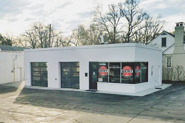
Old Gas Station
Head east and at 9910 Manchester Rd. to your right is an old two-service bay, oblong box, 1950s gas station. Though very close to Rock Hill it is part of Kirkwood. Pictured below.
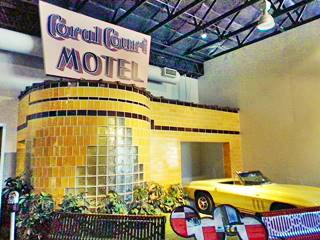
The rebuilt cottage from Coral Court Motel. Source
Museum of Transportation
A short 4.5 mile drive from downtown Kirkwood, see this map directions.
Located at 3015 Barrett Station Rd, Their website.
From steam locomotives to automobiles from 1901 to the 1960s, worth stopping by. Admission fee is charged. Portions of the old Coral Court Motel are preserved here.
This leg of your Route 66 Road Trip ends here, head west into Manchester along the 1926-32 Route 66 or along the later alignment through Sunset Hills to continue your journey.

Some sponsored content
> > Book your Hotel in Lebanon

Credits
Banner image: Hackberry General Store, Hackberry, Arizona by Perla Eichenblat


