Route 66 in Marlborough, Mo
Index to this page
- About Marlborough
- Marlborough's Weather
- Hotels and accommodation
- Map of US 66
- What to see and do in Marlborough

TheRoute-66.com is reader-supported. When you buy through links on our site, we may earn an affiliate commission at no additional cost to you.
About Marlborough Missouri
Facts, Trivia and useful information
Elevation: 538 ft (164 m). Population 2,727 (2020).
Time zone: Central (CST): UTC minus 6 hours. Summer (DST) CDT (UTC-5).
The "Village of Marlborough" is a small town located on the 1932-1977 Route 66 alignment in St. Louis County, central-eastern Missouri just west of St. Louis city.
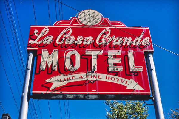
La Casa Grande motel's neon sign back in 1988
History of Marlborough
This part of Missouri was peopled some 10,000 years ago at the end of the last Ice Age. There are some earth mounds in the region, in Fenton and the
Historic Monk’s Mounds and Cahokia Mounds World Heritage Site on Route 66 in Collinsville IL, built by Native Americans around AD 1050 - 1400.
In historic times, the French exporers from Canada reached the region in 1683 and met natives of the Algonquin nation who called themselves "Illiniwek" or "men" in their own language. These hunter-gatherers grew corn, squash and beans. The French corrupted their name to "Illinois".
The French named the land after their king, Louis IV: "Louisiana" and in 1764, Laclede and Chouteau founded St. Louis; settlers arrived shortly after.
The French sold Louisiana to the United States in 1803 and shortly after, in 1805, Thomas Sappington settled there; his House built in 1808, and their Cemetery (1811) survive in neighboring Crestwood.
St.Louis incorporated and became a municipality in 1809. The Territory of Missouri was created in 1812, and it became a state of the Union in 1821. In the 1830s the Native Americans were relocated to reservations in Oklahoma. This was a rural community with farms. After the Civil War, it grew slowly. Watson Road dating back to the late 1800s was named after Wesley Watson who owned a sand and gravel pit used in construction. Route 66 was aligned along it in 1932. Urban development in the post-war years converted it into a commuter suburb of St. Louis.
The Name: Marlborough
The name comes from a Norman family that lived at Marbury manor in Cheshire after 1066 AD. The manor's name was deformed to Marlborough. The town is probably named after the famous General, Duke of Marlborough or other towns named after him.

Hotels and Motels: Marlborough, Missouri
You can find accommodation and hotels in neighboring Sunset Hills, 3.5 miles away:
> > Book your accommodation in the area: Bridgeton, St. Louis, or Kirkwood
More Lodging near Marlborough along Route 66
There are several hotels in the area close to this town. Alternatively you can also find your accommodation along Route 66 in the neighboring towns and cities in Missouri. We list them below (from east to west):
On Route 66's Main alignment in MO
Eastwards
Westwards
- Hotels in Kansas
- Baxter Springs KS
- Galena KS
- Riverton KS
- Hotels in Oklahoma
- Miami OK
>> Check out the RV campground in neighboring Fenton
Weather in Marlborough
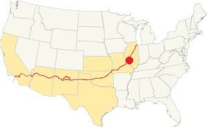
Location of Marlborough on U.S. Hwy. 66
Marlborough has four well marked seasons. It is located in the area where humid continental climate shifts towards a humid subtropical climate, so summers are hot and humid while winters are cold. It gets cold Arctic air and hot damp tropical air from the Gulf of Mexico. Spring is wet and may have extreme weather (tornados, thunderstorms and even winter storms). Fall is sunny and less humid, with mild weather.
The average high in winter (Jan) is a cool 39.9°F (4.4°C) while the average low is a chilly 23.7°F (-4.6°C). The summer (Jul) average high is 89.1°F (31.7°C) and the average low is 71°F (21.7°C).
Rain is on average 41 in. (1.041 mm) with the rainiest months being May through July with over 4.1 in monthly (104 mm). Snow falls between Nov. and Apr., with a total snowfall of 17.8 in. (45 cm). Relative humidity is fairly stable year round at 70%.
Tornado risk
The town is located in Missouri's "Tornado Alley" and St. Louis County is struck by some 7 tornados every year.
Tornado Risk: read more about Tornado Risk along U.S. 66.
Map of Route 66 in Marlborough Missouri
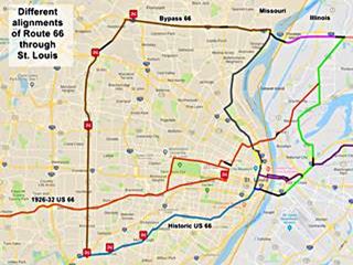
The map shows Route 66 in the St. Louis Region. The color key for the map is:
Orange: is first, the original 1926-32 alignment of US-66 through St. Louis
Brown is the Bypass US-66.
Pale Blue: Is the Historic Route 66 alignment after 1932 into St. Louis, from the west. Marlborough is along this alignment (lower left).
Blue, Green, Gray, Pink, Yellow, and Violet show different courses taken by US 66 over the years.
Black: missing segments.
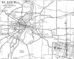
The following map from 1955 shows Route 66 in St. Louis vicinity. Marlborough is located on the south side, along Wastson Rd. on "City 66".
US 66 in Marlborough
Crestwood is adjacent to Marlborough, heading west along Old Route 66 - Watson Road, it is a short 2.7 mile drive , and this is the Map with Directions.
Route 66: created in 1926
US highway 66's original alignment from 1926 to 1932 ran to the north of Marlborough it had an east-west course through Kirkwood along Manchester Rd. and therefore avoided having to cross the Meramec River between St. Louis and Villa Ridge. It is shown in Orange in the Map above; linking St. Louis & Maplewood in the east with Gray Summit in the west.
1933-1977 alignment Route 66
In 1932 a shorter and straighter alignment was built routing the highway along Watson Rd. This paved highway required two bridges to cross the Meramec, one at Sylvan Beach, to the west of Marlborough and another at Times Beach. Now this road is now partly overlaid by I-44 west of S. Geyer Rd. and Watson, in Sunset Hills. Eastwards, into St. Louis, the original road is shown in Pale Blue and was known as the "US City 66" alignment.
There were many Route 66 alignments in St. Louis, only one went through Marlborough. In 1977 the US 66 shields and signs were removed marking the end of an era.
The Route 66 alignment in Marlborough
Visit our pages with old maps and plenty of information about US 66's alignments.
- Gray Summit to Rolla (next)
- Route 66 St. Louis to Gray Summit (In Marlborough)
- Route 66 Hamel IL to St. Louis MO (previous)
Route 66 Sights in Marlborough
Marlborough and its Route 66 attractions
Historic context, the classic Route 66 in Marlborough
Neither the WPA travel guide "Missouri, a guide to the "Show Me" state" published in 1941 or Jack DeVere Rittenhouse's 1946 classic "A Guide Book to Highway 66" mention Marlborough. But, Rittenhouse does mention an iconic motel in Marlbrough, that has survived until today: "Other courts on west side of town are Wayside ..." and the now gone Bluebonnet.
Your Route 66 Road Trip through Marlborough
This is a very short (an 2.5 mile-long drive) tour. See this Map with directions; it begins on the eastern side of town in neighboring Shrewsbury:
Shrewsbury
Elevation: 541 ft (165 m). Population 6,108 (2020).
Time zone: Central (CST): UTC minus 6 hours. Summer (DST) CDT (UTC-5).
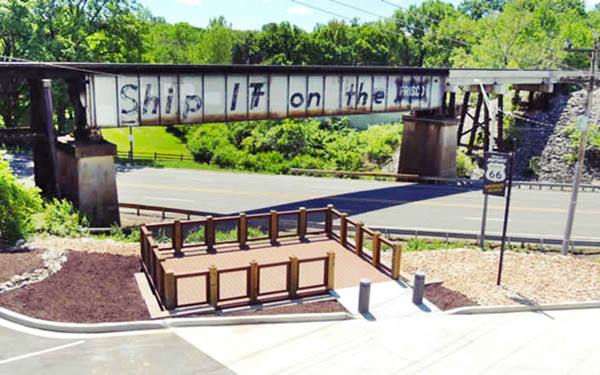
Shrewsbury is located on the eastern side of Marlborough, next to St. Louis' city limits. It has only one Route 66 attraction: the Frisco Railroad underpass.
The post office operated in Shrewsbury from 1893 to 1904, and it is named after the town in England. The name comes from the Old English Scrobbersbyrig, that combines the words: scrobb (scrub) and byrig (fort) hence: "Fortified Place in the Scrubland."
Frisco Railroad underpass
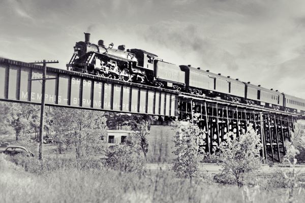
The deck plate girder bridge was built in 1931. It carried the tracks of the St. Louis-San Francisco Railway or "Frisco" across the Watson Rd. It has the original railroad slogan painted on it: "Ship it on the Frisco". The city built the The Route 66 Photo Deck next to it (with parking space). Below is a view of the deck and the underpass, the original lumber trestle approach was filled in with rock and gravel and the wood beams were replaced with steel ones after the tressle was rebuilt when a train derailed here in 2002.
Marlborough
Its Route 66 sights
Head west along Route 66 and enter Marlborough, to an old gas station.
Rischbeiter’s Garage
As you enter Marlborough, at 7750 Watson, to your left is this one-story, flat roof, concrete block building with a 3-bay garage and office. It was built around 1941 and you can see it in the center of this image,
an aerial photo taken in 1958 that shows US 66 running from right to left (east to west), Coral Court on the upper left,
the Wayside Motel on the lower left, and the now gone Crystal Motel behind the gas station.
Crystal Motel
Built in 1946 between US 66 and the railroad tracks, its was torn down around 1990 and replaced by a medical supply store.
This area had many motels west towards Bypass 66, but now only a few remain.
Coral Court Motel (Gone)
Listed in the National Register of Historic Places
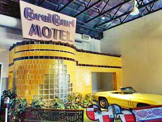
The rebuilt cottage from Coral Court Motel. Credits
This vanished historic site was located to your right, at 7755 Watson Road. John Carr built it in 1941 with 10 cabins, another 23 were added in 1948 after WWII. It had yellow honey-colored glazed ceramic bricks and glass block windows with curved lines in an Art Deco style.
No-Tell Motel
The motel was "St. Louis' little sin" here many St. Louisans had one-night stands, where rooms could be rented for 4 or 8 hours, and they had garages that concealed the cars from prying eyes.
Murderers caught at the sleazy motel
Carl Austin and Bonnie Headly kidnapped a six-year old boy, Bobby Greanlease Jr. in Kansas, in 1953. They cashed the $300,000 ransom and killed the child. They hid at this motel and were captured here. Convicted and executed, the ransom money was never found.
Demise
In 1993 the motel was forced to close due to structural deficiencies. Though funds were raised to save it, it was bought by Conrad Properties to develop the real estate as "Oak Knoll Manor Drive and Court". The motel was torn down in 1995. And the Museum of Transportation in neighboring US 66 town of Kirkwood dismantled one complete bungalow which is now partially rebuilt and displayed at the museum: a curved glass block wall and part of its garage (pictured above).
At the original site the only physical remains are the two stone entrance gate walls:
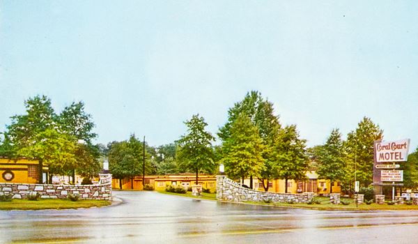
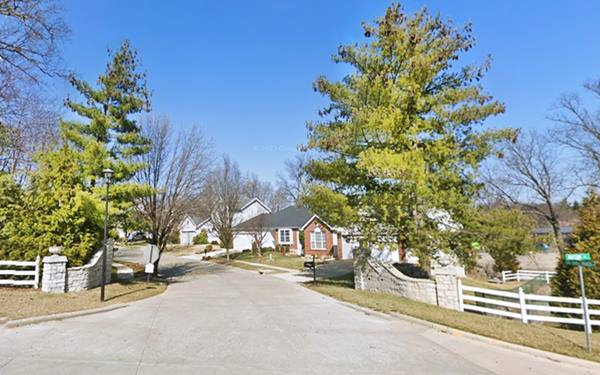
The signs that lay atop the stone entrance walls have survived and are on exhibition at the Visitor Center at Times Beach - Route 66 State Park further west near Eureka (see picture below).

Entrance sign, Coral Court Motel. Credits
Wayside Motel
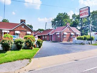
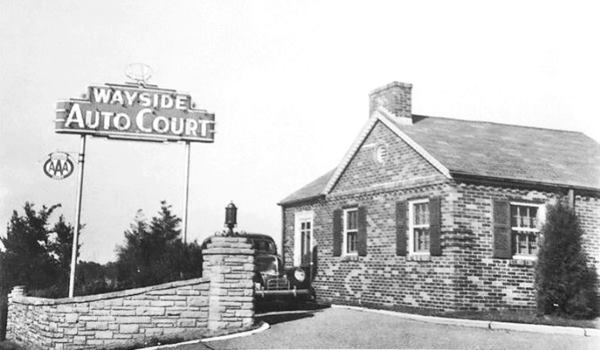
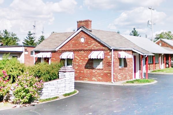
Continue west. Ahead, to your left, on the hillside is the classic Wayside Motel, pictured above.
At 7876 Watson. This motel dates back to 1938 and was located opposite the Coral Court Motel. Well preserved as it is was built in bricks, it had 33 brick cottages around an "L-shaped" inner courtyard. Jack Rittenhouse mentioned it in his 1946 guide book to Route 66, and it is still open. Below is a "Then and Now" sequence of the same unit, the neon sign has gone, replaced by a modern one:
Just beyond it, also to your left is the Chippewa Motel:
Chippewa Motel
At 7880 Watson, Marlborough. It was originally known as "Chippewa Tourist Cottages" this motel (pictured below), built in 1937 it had 13 individual cottages with a U-shaped layout and three wings. By the late 1940s the separate units had been linked and the place had acquired its current appearance. Nowadays it is an apartment complex. Below is a Then and Now sequence, notice how the neon sign has changed over the years:
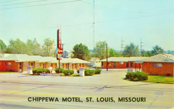
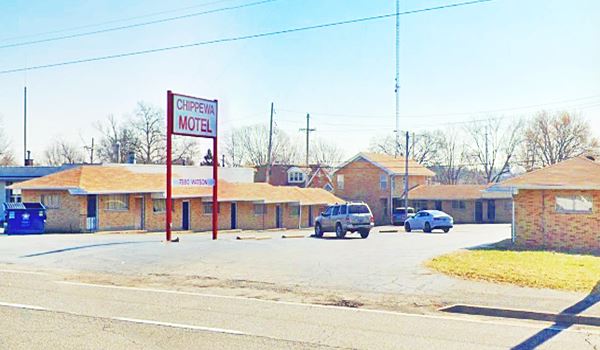
Duplex Motel
Further west, to your left at 7898 Watson is the former "Duplex Tourist Cottages" that later became the "Duplex Motel". The current layout has a linear ("F-shaped") layout with 15 units.
The original premises were built in 1936 with a "motor camp" layout, with 11 separate gable roof cottages, these buildings are still standing on the back part of the property behind the modern units that face the highway you can see them in the following pictures:
Red box marks the buildings that are still standing at the back of the property.
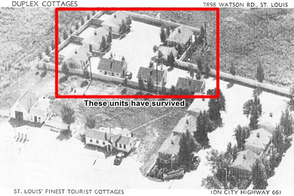
The back part of Duplex Motel, with the original units
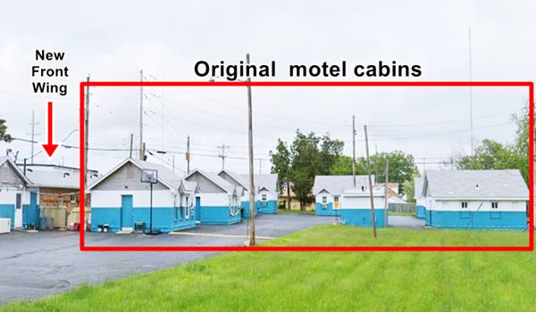
The front of the Duplex Motel with its neon sign
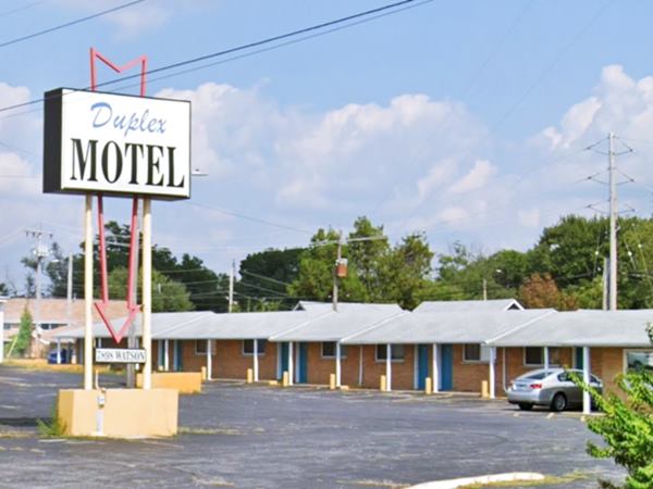
There were other motels, but they have been torn down: Rest-Wel Motel (8020 Watson), Missouri Hotel (8084), Roxie’s Motel (8300), Cordia Courts (8498), Alma Courts (8544), and the Catalina Court (8550 Watson). Lost for good! Only one has survived:
La Casa Grande Tourist Camp
At 8208 Watson, to your left, below the level of the highway. Below is a "Then and Now" set of images showing the same view of the old motel:
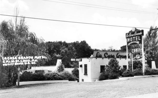
The former La Casa Grande Motel in Marlbrough, Missouri
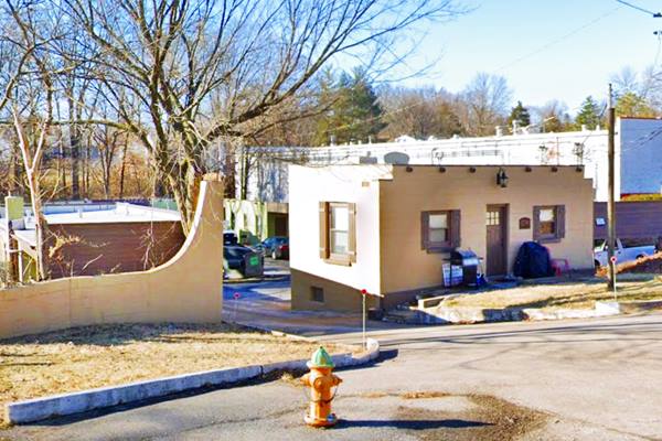
The "La Casa Grande Tourist Camp" was built ca. 1940 as a Tourist Camp, with 8 individual units and modelled after the old Alamo Motel chain: a combination of Spanish, Mediterranean and Mission styles (with a Pueblo village appearance).
It now has 16 units located in a "U-shaped" layout with covered garages linking the cabins. There is a creek behind it and the office faces the highway on the northern side of the property.
It had a neon sign pictured at the top of this page, but it was removed in 2005 and is part of the Greg Rhomberg Antique Warehouse Collection in St. Louis (learn more about this neon sign.)
This part of your Route 66 road trip across Marlborough ends here; drive west into Crestwood to continue your itinerary.

Some sponsored content
> > Book your Hotel in Lebanon

Credits
Banner image: Hackberry General Store, Hackberry, Arizona by Perla Eichenblat
Jack DeVere Rittenhouse, (1946). A Guide Book to Highway 66.


