Route 66 approaches the Mississippi River: Edwardsville IL
Index to this page
All about Edwardsville, Illinois
Trivia, Useful Information & Facts
Elevation: 452 ft (138 m). Population 26,808 (2020).
Time zone: Central (CST): UTC minus 6 hours. Summer (DST) CDT (UTC-5).
The city of Edwardsville is the county seat of Madison County, Illinois. Part of the Metro East region of greater St. Louis.
History of Edwardsville
Humans have lived in Illinois since the retreat of the glaciers at the end of th last Ice Age some 12,000 years ago. For the early history of Madison County, read this.
There was an ancient and well-marked Indian Trail known as "Edwards Trace" running north to south across central Illinois. The buffalo had opened a trail across the prairies and groves of trees. You could follow it from Springfield in the north to Kaskaskia in the south. It crossed Edwardsville on its way.
It is the third oldest city in the State of Illinois.
Herby the Hereford in Edwardsville, Illinois
The first settler was Thomas Kirkpatrick, in 1805. In those days the European and Americans living along the shores of the Mississippi in the region known as "American Bottom" moved easts, leaving the low-lying flood plain and moved into the higher ground above the river bluffs and into the tallgrass prairies of Illinois.
A community flourished and Kirkpatrick named it after his friend Ninian Edwards. It incorporated in 1818. It was a farming community on the main trail into Central Illinois.
Route 66 was aligned through the community in 1926 and remained so until the early 1960s.
The Name: Edwardsville
The town was named after Ninian Edwards (1775 – 1833) then Governor of the Illinois Territory (1809 to 1818). He was one of the first two United States Senators from Illinois from 1818 to 1824, and as the third Governor of Illinois from 1826 to 1830.
Reaching Edwardsville
Get to Edwardsville driving along Historic U.S. 66 or take the freeways: I-270 or I-55 and State Hwy 157.

Edwardsville: its Hotels and Motels
Lodging & accommodation in Edwardsville
> > Book your hotel in Edwardsville
More Accommodation near Edwardsville on Route 66
Below you will find a list of some of the towns along Route 66 east and west of this town; click on any of the links to find your accommodation in these towns (shown from east to west):
Along Route 66 in IL
- Hotels in Illinois
- Route 66 Starting point ▸ Chicago
- Lockport
- Willowbrook
- Bolingbrook
- Plainfield
- Romeoville
- Joliet
- Wilmington
- Dwight
- Pontiac
- Chenoa
- Normal
- Bloomington
- Atlanta
- Lincoln
- Springfield
- Raymond
- Litchfield
- Staunton
- Williamson
- Hamel
- Edwardsville
- Collinsville
- Troy
- Glen Carbon
- Pontoon Beach
- Granite City
- East St. Louis
West in Missouri
- Hotels in Missouri
- Florissant MO
- Bridgeton MO
- St. Louis MO
- Kirkwood MO
>> Check out the RV campground in Mitchell
Edwardsville's weather
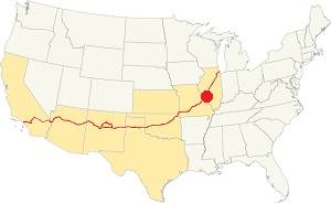
Location of Edwardsville on U.S. Hwy. 66, Illinois
Average summer temperatures (Jul) are 90°F (32.2°C) -high, and 70°F (21.1°C) -low. While the winter averages are (Jan) 36°F (2.2°C) and a chilly 19°F (-7.2°) respectively.
Rainfall his fairly even throughout the year with peaks of 4.2 inches in April and May. With a minimum of 2 inches (51 mm) in January. Expect snow in winter.
Tornado risk
Edwardsville is in an area that is hit by about 7 tornados per year, so your chances of seeing one are not that large.
Tornados in Edwardsville
The F4 tornado of April 3, 1981 ripped through the town causing $5 Million in damage but no casualties.
The EF-3 tornado of December 10, 2021 hit an Amazon warehouse killing six workers who had taken cover there.
On December 10, 2021, an EF-3 tornado hit the warehouse causing it to collapse, killing six workers who were trying to take cover inside.
Tornado Risk: learn more about the Tornado Risk on US 66.
Map of Route 66 through Edwardsville
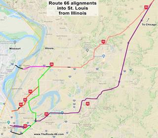
Route 66 alignments
Click on the Map to see a large sized map showing Route 66 alignments that go into St. Louis MO from Illinois.
In this map is Black lines mark the missing segments that can no longer be driven.
Original 1926-62 alignment
>> See our Custom map with all the alignments of US 66 into St. Louis from Illinois.
The original 1926-54 US 66 map (and later 1954 to 1962 BYP66)
This alignment is marked in pale pink in the map (click on it to enlarge). It was used until the new "Main 66" was built from Hamel through Collinsville and Fairmont City into East St. Louis in 1954. Then the segment from Hamel to Mitchell through Edwardsville became the Bypass 66.
Finally, in 1962 Route 66 was aligned along the 4-lane highway from Hamel through Troy and Colinsville bypassing Edwardsville and Mitchell.
The Route 66 alignment in Edwardsville
Visit our pages with old maps and plenty of information about US 66's alignments.
- Route 66 St. Louis to Gray Summit (next)
- Route 66 Hamel IL to St. Louis MO (In Edwardsville)
- Springfield to Hamel IL (1930-77 previous)
- Springfield to Staunton IL (1926-30 US66 previous)
Route 66 across Illinois
Historic Route 66 has been designated as an All-American Road and a National Scenic Byway in the state of Illinois.
Click for a description of Route 66 in Illinois.
Edwardsville: its classic Route 66 Sights
Attractions & Landmarks
US 66 Historic context
Jack DeVere Rittenhouse published his "A Guide Book to Highway 66" in 1946 and he mentions Edwardsville, which in those days had 8,008 residents. He wrote:
Bothman garage; hotels: Leland, Colonial; homes offer rooms for tourists; gas; cafes... Several Indian and pioneer relics are on display in a county historical museum here Rittenhouse (1946)
Rittenhouse added that 6 miles east of town and 3 miles west of Hamel was the "Green Gables tourist court and gas station", followed by another one 2 miles west, the motel is standing, the gas station vanished.
Tour of Edwardsville
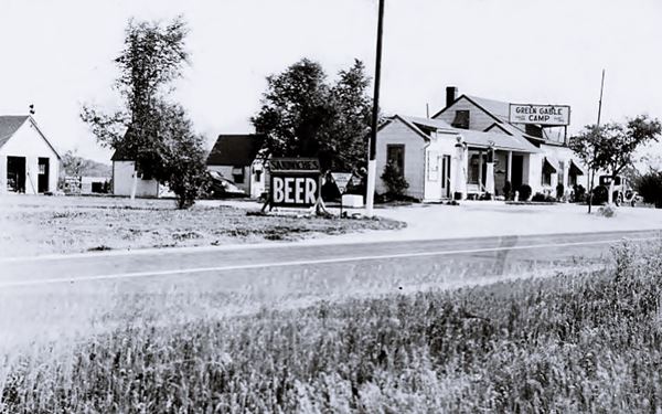
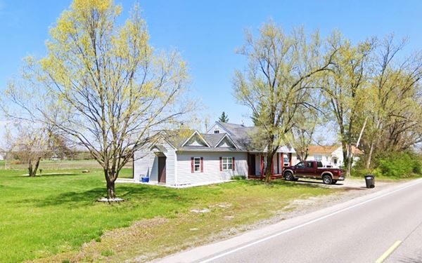
Green Gable Camp
Head into town from the east along Historic Route 66 coming from Hamel, and you will pass by this tourist court and filling station mentioned by Rittenhouse in 1946 (to your right).
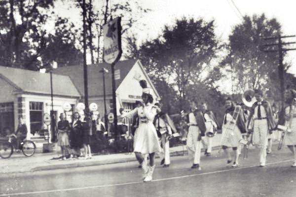
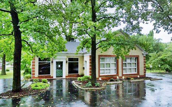
He called it Green Gables tourist court, but it was "Green Gable Camp" (singular not plural). It was opened by Harry Baumgartner in 1931. You can see the main building and the cabins in this 1955 aerial photograph. The building has been greatly altered over the years, but looking at this 2008 view you can still make out the original western wing of the building. Below is a "Then and Now" set of pictures:
Bolch's Trackside Service
Mentioned by Rittenhouse 2 miles west of Green Gables. It was located to the left, between Route 66 and the now removed railroad tracks that ran parallel to the highway. There was an office with pumps in the middle and above-ground gasoline tanks at each end. The fuel arrived in railway tankers. Long Gone (1955 aerial photo and location map.)
Head west. The highway crosses Mooney Creek and climbs Mooney Hill, turning towards the south to become Hillsboro Ave as it reaches Edwardsville.
Alibi Tavern - Ray Ann Café
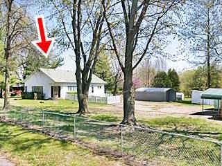
To your left at 4500 Hillsboro was the "Alibi Tavern" that opened in 1946. It was built by Lestern Gebhart, a carpenter and the Gebharts ran it for many years. Ann Scheibe and her associate Ray Cabello ran the Gebhart family's Alibi tavern and restaurant for a number of years and renamed it "Ray Ann Café". The building on the right in this 1968 aerial photo was located at the northern tip of a large parking lot where trucks could park and turn around. It was 150 ft (50 m) long. This 1955 aerial photo shows the same gable roof building (right side of US66) and some parked trucks. The old building is pictured below.
Ahead, to your right at 931 Hillsboro was the "Little White Kitchen" restaurant, it was torn down but the wide gravel shoulder marks the spot (street view)
Old Halley Store
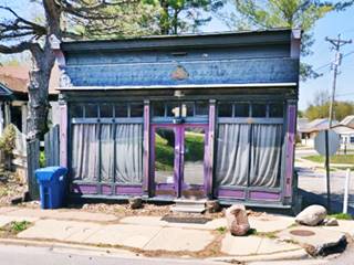
On the next block, to your right, at 817 Hillsboro on the SW corner with Chapman St. The old store dates back to 1910. It was the first grocery store east of town; originally the Superior Cash and Carry Grocery, it became Halley's Cash Market in 1927 and was ran by Thomas and Mayme Halley until 1972. Later it became Springer's Creek Winery (closed).
Shell and Champlin Station
Ahead, at the corner where Hillsboro turns off to the right, and Route 66 becomes St. Andrews Ave. Here, to your right at 701 Hillsboro is a fomer Champlin service station, now "The Store". It was also a Shell station over the years. The outline of the pump island can be seen in the concrete driveway (street view).
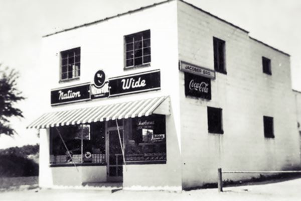
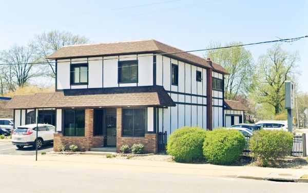
Jacober's Market
Across Hillsboro, on the SW corner (141 St. Andrews) is an old market. Oliver "Ollie" and Norma Jacober built in in 1947 and ran it until 1973. The building is still standing, and below is its "Then and Now" sequence:
Site Gas station
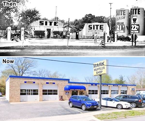
Adjacent to Jacober's at 139 St. Andrews St. was the site of Hogue's Site gas station (pun intended). Site was a gas station chain owned
by Phil Siteman and based in St. Louis MO. The filling station had a small box-shaped office and tanks above the ground. It dates back to the late 1940s. Below is a "Then and Now" set of photos. The old gas station was completely torn down and replaced by Mark Muffler Shop
Blackie Hogue also owned the gas station on the corner (read below).
Old Hogue Filling Station
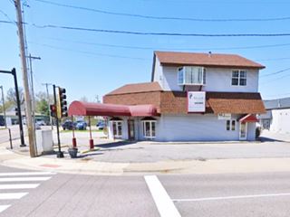
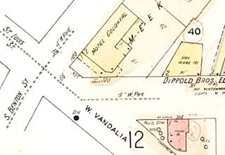
Just ahead, to your right, on the NW corner of St. Andrews and W Vandalia streets, where Route 66 turns right, is a gas station that has been here at least since 1930, In 1938 it was the "Harrell Dixcel" station . Later it was operated by Blackie Hogue and, according to one source was a Fina station, and according to another a Phillips 66 station operated by Jim Garde (?). The building appears in the 1930 Sanborn Fire Insurance map (pictured) as "fll'g sta" with concrete floring on its northern part and an angled, chamfered area facing the corner with a canopy extending from it. The canopy his supported by two steel poles. The second floor is a later addition to the building.
Hi-Way Cafe
Turn right and head west along East Vandalia. Here the highway had a grade crossing over the tracks of the Litchfield & Madison Railroad. Ahead, to your right on the NW corner of W Vandalia with N. Brown St. (461 E Vandalia) is the former Cafe.
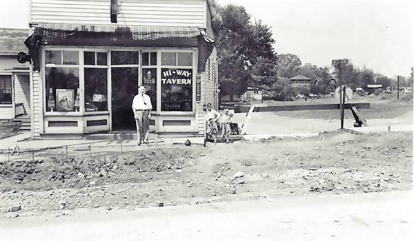
Frank and Dorothy Catalano opened the Hi-Way Tavern in 1934, and converted it into a Café in the 1940s after their "competitor" Cathcart's Cafe added a bar to their restaurant.
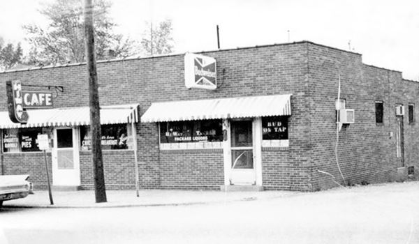
The old woodframe building became a red-brick one In 1947 Catalano sold his place to the Lautners who ran it until 1960 (Frank died in 1964).
A December 1950 advertisement announced "Open All Night HI-WAY CAFE - 461 East Vandalia St. Edwardsville Ill. WE SPECIALIZE IN Italian Spaghetti & Ravioli Home Made Pies Chili BBQ Soup - We Feature 5c COFFEE - George and Mary Lautner Prop."
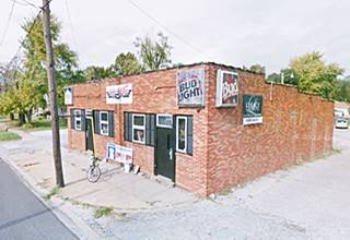
In the 1930s while it was still a "Tavern" (see windows), Route 66 was being paved at that time
In the 1960s. Notice the neon sign to the left.
Cathcart's Café, Tourist Inn and Cabins
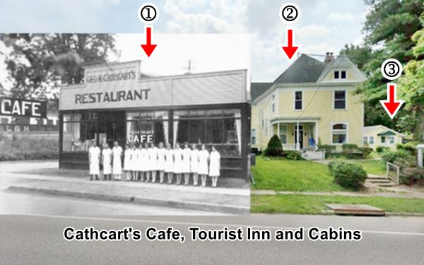
Opposite Catalano's, at 456 E Vandalia St., was the Cathcart's tourist complex. In 1922 George B. Cathcart bought Hotz's House (454 E Vandalia) for $9,000 (roughly $153,000 in 2022 values), a two story, gable roof Victorian home built in 1897; he turned it into a boarding house.
Mrs. Cathcart ran it and she called it "Cathcart’s Tourist Inn." It could accommodate twelve guests.
That same year, the Cathcarts purchased the adjacent property and opened a Restaurant and Café on the SW corner with S. Brown. It was open 24 hours a day and had a Greyhound bus terminal next to it. It opened a bar in the 1940s and competed with Catalano. The building was torn down in the 1990s and another one stands on the property.
As business flourished they added several tourist cabins next to the main house, some of which have survived until today.
The image below is a composite of the current view and an old photograph of the café You can see the café (1), followed by the Tourist Inn (2), and one of the surviving cabins (3).
They sold the house and cabins to the Goddards in the 1930s who kept on renting rooms as "Goddard Tourist Home and Cabins."
Brick paved street
Head west, as you approach St. Boniface church, look right to see a street paved with red bricks, north along North Filmore St. This is the Street view of Red Brick paving. Paving with bricks was a common practice in the early 20th century.
> Read more about Brick paved sections of Route 66.
St. Boniface Church was built in 1869. Across Route 66 (left) was Weiler and Sons Texaco Service (302 E Vandalia St). Razed. One block south, on the corner of S. Buchanan and E. Park was McLean; 2013 St. View also torn down.
historic Czech Building
Listed in the National Register of Historic Places
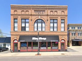
237 E Vandalia St, in the middle of the block to your right. The Historic red-brick hall reads on its facade: Narodni Sin 1906 and the initials CSPS (Czecho Slovak Protective Society). It was built in 1906 for Lodge Nbr. 7 which was housed here from 1906 to 1971. All meetings were held in the Czech language until 1958.
The lower level was leased to soft drink and liquor establishments until 1969. The first Czechs in the Edwardsville as farmers and laborers after 1851, escaping turmoil in the Austrian Empire in 1848.

Orman's advertisement. Route 66 Edwardsville IL.
On the corner adjacent to the Hall was Earl Orman's Standard Service Station (201 E Vandalia), it was "open 6:30 to 10:30 7 days a week". Long gone.
On the next block, to your left is a former hardware store repurposed as a pizza shop:
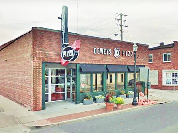
Kriege Hardware ⁄ Deweys Pizza
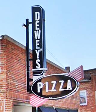
At 112 E Vandalia St, Dewey’s Pizza occupies the red-brick building that used to be the Kriege Hardware store. It opened in this building back in 1948. The sign survived the closure of the store in 2011 and restored the word "Hardware" was replaced with "Deweys" and "Kriege" with "Pizza". The store is pictured below and further down is the original sign before it was restored, and its renovated version:

Original Kriege Store neon sign, Edwardsville, Il. Credits
Old Kriege Hardware ⁄ now Deweys Pizza in Edwardsville, Illinois
Half way down the block (104 E Vandalia, to your left) is the "Stagger Inn", in a red-brick building that has been serving as a tavern for decades: it was "Eddie's Cafe and Tavern" in the 1930s, the "Rainbow Inn" in the 1940s, "El Del Uptown Tavern" (named after its owners Elmer and Della Gueldner), in the 1950s. This is its street view.
Ahead is the intersection of Route 66 and Main Street. Take a right along Main to vosot a classic example of Wacky - Weird & Americana Route 66 sights: it is on the second block, to your right.
Fiberglass steer store sign
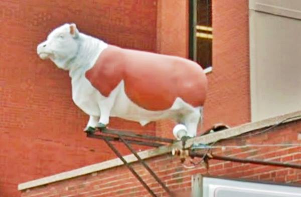
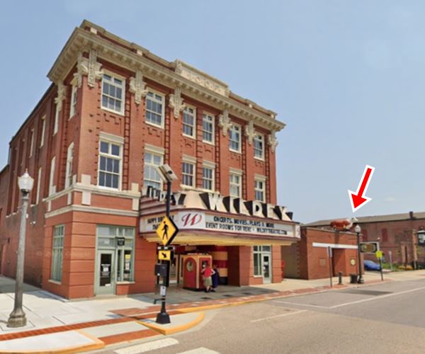
At 246 N. Main St. Goshen butcher shop is crowned by the iconic "Herbie the Hereford" a life-size fiberglass steer. It is highlighted in the image below with a red arrow. The shop opened in 1947.
At the top of the page is a detailed view of "Herby the Hereford".
Wildey Theater
Next to the butcher shop is this classic theater that was built as an opera house in 1909 and also housed the IOOF (written in white stone on the third floor's parapet); the Independent Order of Odd Fellows (IOOF) is a secret society without any political or sectarian orientation. It was founded by Thomas Wildey in Baltimore, USA in 1819.
It closed in 1984 and was acquired by the city in 1999 and renovated.
Fiberglass steer store sign in Edwardsville, Illinois
Retrace your steps to Route 66.
Leland Hotel (Gone)
On the south corner of Main and St. Louis once stood the Leland Hotel. It began as Hoffman House or Empire House in 1888, in 1896 it was remodeled and renamed after its new manager W. L. Leland. In 1923 the corner part of the building was torn down and the Edwardsville National Bank built there, however, the wing facing St. Louis St. (103 W St. Louis - now a plaza) survived. The old building was razed in 1973. Ahead is Vandalia.
On the SW corner was a Deep Rock service station (gone), turn right along W Vandalia ahead was a Phillips 66 (141 W Vandalia, to your right) that was known as Bill Quade's and also as Jack's station (initially owned by Jack Minner and Jack Gerhardt).
The Wabash railroad had a spur cutting across Vandalia here (to the left were the grain elevators and the famous Creamery). After the grade crossing, to the left was Fruits' Standard Station and, also to your left at 302 W Vandalia it was Bothman's Garage and Ford deealership its gone; now a bank stands there.
To your right, on the NE corner of W Vandalia and St. Louis (316 St. Louis) was Adams Standard service station (it is highlighted in pink in the map below), now a fountain stands on a nice plaza. West Vanalia ends here and St. Louis continues westwards.
Colonial Hotel (Gone)
Ahead, in what is now the parking lot of the First Mid Bank once ran N. Benton. On the NW corner of N Benton and St. Louis was the Colonial Hotel.
Rittenhouse mentioned it in 1946, and it had been knwon as "The Edwardsville Hotel", "Union Hotel", "Pfeiffer", and "Vanzo Hotel over the years. It was torn down in the mid 1960s.

Edwardsville Hotel vintage postcard. Credits
Route 66 becomes St. Louis, continue west for three blocks, and at West St. Route 66 turns sharply to the right was another service station:
West End Service Station
On the SE corner at 198 West St. Originally a Madison Oil Co. station that opened in 1927. It was named the West End Service Station in 1936 when the new yellow-brick building was built.
Thomas Bar and Ralph Ellsworth operated it for some time before moving west along Route 66 (on the corner of W Schwarz, where the Circle K is).
It is stil there, with its "house" style from the 30s. Pictured below:
Route 66 Shield Monument
Keep westbound, 300 yards south is another landmark. As part of thte "Six on 66" monuments, the town erected a 12.5-foot monument shiled opposite Lincoln Middle School, on the SE corner of IL-157 and W Schwarz St. There are other similar shields in Carlinville, Litchfield, Collinsville, Granite City, and Hamel.

Edwardsville IL. Route 66 shield monument.Source. Click for St. view
Legate's motel & Hilltop House Restaurant
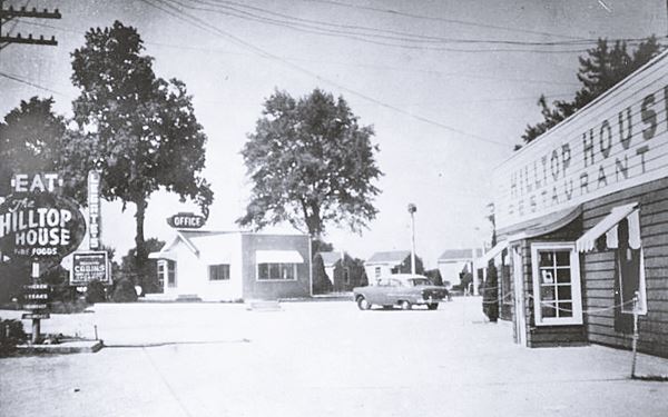
Just 0.8 mi ahead, to your right is the site of the old Hilltop Restaurant and Legate's Motel built in 1948 by Virginia and Orval W. Legate.
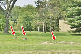
Its advertising said it was "A Home Away From Home". It had 19 units and a trailer park, all that survives are two concrete foundations in a field (see picture).
Wolf's Motel ⁄ Gerver's (Gone)
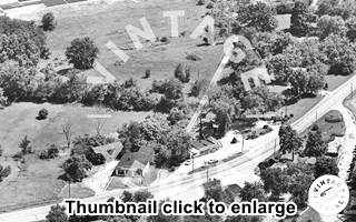
Wolf's motel was across the road from Legate's and was open during the mid 1960s and early 1970s. During the 1950s it had operated as the Gerber's motel and had a gas station. The image (click on the thumbnail to enlarge) shows Legate's (lower right) and Wolf's (middle) with Route 66 curving between them. It was torn down in the early 1990s and nothing remains.
Further west (3080 S State Rte 157) is the late 1960s Holiday Inn where the Comfort Inn Edwardsville is now located. It had "157. 150 Spacious rooms - Dining room - Cocktail Lounge - Swimming Pool - Banquet Rooms."
And this is the end of your drive through Edwardsville, head west to continue your Route 66 Road Trip and visit Mitchell.

Sponsored Content
>> Book your Hotel in Chicago

Credits
Banner image: Hackberry General Store, Hackberry, Arizona by Perla Eichenblat
Jack DeVere Rittenhouse, (1946). A Guide Book to Highway 66.


