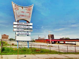
A city with many empty lots
Index to this page
- About East St. Louis
- Weather
- Hotels in East St. Louis
- Map of US 66 in East St. Louis
- What to see and do in East St. Louis
All about East St. Louis, Illinois
Trivia, Useful Information & Facts
Elevation: 417 ft (127 m). Population 27,006 (2010).
Time zone: Central (CST): UTC minus -6 hours. Summer (DST) CDT (UTC-5).
East St. Louis is St. Clair County, Illinois, across the Mississippi River from St. Louis, Missouri.
History of East St. Louis
Humans have lived in Illinois since the retreat of the glaciers at the end of th last Ice Age some 12,000 years ago.
There were up to 50 "Indian Mounds" in the area most lost to development and road building. They were ceremonial and burial sites of the local "Mississippian culture" which flourished from 900 to 1500 A.D., their capital was located at Cahokia Mounds in neighboring Collinsville. They were farmers and hunter-gatherers. Famine due to drought led to their demise.
During the 1600s Illiniwek natives (Peroria, Kaskaskia, Kkahokia and more) moved here escaping war with the Iroquois.
This region was first mentioned by French Jesuits in 1656; they had heard about the "Illinois" natives from a party of Algonquins.
Father Marquette reached the area in 1673 and settled in Kaskaskia and Cahokia.
The territory was a French posession but France ceded it to Britain in 1763. It became part of the US after its independence in 1776.
Arthur St. Clair the governor of the Northwest Territory created St. Clair County in 1790 (naming it after himself!) It was the first county established in what nowadays is Illinois, the county predates the state!
In 1801 it passed to the Indiana Territory, and back to Illinois when the territory was created in 1809.
Illinois became a state in 1818. What is now East St. Louis was founded in 1797 by Captain James Piggott, a Revolutionary War veteran; he named it "Illinoistown".
The Name:East St. Louis
The municipality was established in 1861 and the residents voted on a new name for the town: East St. Louis, after the large city on the western bank of the Mississippi River.
The town grew after the Civil War with stockyards, meat packing and the railroad. It grew into an industrial town with cheap labor that suited the employers and this led to the tragic events of 1917:
The 1917 East St. Louis Race Riot
Black workers were eager to move into the industrial area around St. Louis, to flee from discrimination and poorly paid farm jobs in the Deep South. At the same time, white workers were striking to pressure employers to pay better wages. The companies hired black workers as strikebreakers. This created racial tension between whites and blacks. The former fearing blacks would work for lower wages and displace them from their jobs. The situation came to a head with several thousand white men marching into the city and attacking African Americans in the streets. They burned buildings, mudered 100 to 200 blacks, left 6.000 of them homeless when the rioters burned rail cars on the tracks next to the place where many African American families lived. A shameful situation compounded by the inaction of the local police and the National Guard who were ordered not to shoot white rioters, therefore enticing them to continue.
At S. 5th St. and Railroad Avenue there is a marker that remembers the Race Riot (street view), it was erected on the Centennial of these tragic events.
A vanishing city
The bustling industrial city like many industrial suburbs across the US, was hit by loss of jobs in the 1960s as industry relocated and disinvested. This hit the blue collar workers, mostly black residents. White flight added to the problem, white residents left the city, moving out of racially mixed neighborhoods into all-white suburbs. East St. Louis' poulation which had peaked in 1950 at 82,336 plummeted to one third of its former level nowadays.
Abandoned upper middle class homes, East St. Louis
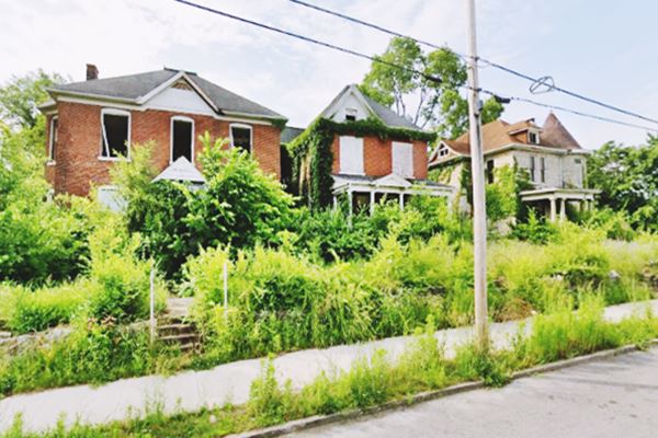
Vacant Lots, empty city
You will see an empty city with few people walking along the sidewalks. Many vacant lots. At one time factories, homes, shops filled East St. Louis. Many were in ruins, overtaken by weeds, decaying and crumbling, boarded up.
As the white residents moved out, the industry vanished, the toll bridge was replaced by a freeway and the town lost its tax base and was unable to provide basic city services. This led to more white flight and disinvestment.
Violent crime is a problem; the city is not a safe place. Be careful.

East St. Louis, its Hotels and Motels
Lodging & accommodation in East St. Louis
> > Book your hotel in East St. Louis
More Accommodation in the area along Route 66
Below you will find a list of some of the towns along Route 66 east and west of this town; click on any of the links to find your accommodation in these towns (shown from east to west):
Along Route 66 in IL
- Hotels in Illinois
- Route 66 Starting point ▸ Chicago
- Lockport
- Willowbrook
- Bolingbrook
- Plainfield
- Romeoville
- Joliet
- Wilmington
- Dwight
- Pontiac
- Chenoa
- Normal
- Bloomington
- Atlanta
- Lincoln
- Springfield
- Raymond
- Litchfield
- Staunton
- Williamson
- Hamel
- Edwardsville
- Collinsville
- Troy
- Glen Carbon
- Pontoon Beach
- Granite City
- East St. Louis
West in Missouri
- Hotels in Missouri
- Florissant MO
- Bridgeton MO
- St. Louis MO
- Kirkwood MO
>> Check out the RV campground in neighboring Granite City
Weather in East St. Louis
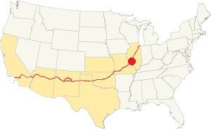
Location of East St. Louis on U.S. Hwy. 66, Illinois
Rainfall is, on average 41 in. (1.041 mm). The most rainy months are from May through July with more than 4.1 in per month (104 mm). Snow falls from Nov. to Apr.: 17.8 in. (45 cm).
The town has four well marked seasons. It is located in the area where humid continental climate shifts towards a humid subtropical climate, so summers are hot and humid while winters are cold. It gets cold Arctic air and hot damp tropical air from the Gulf of Mexico. Spring is wet and may have extreme weather (tornados, thunderstorms and even winter storms). Fall is sunny and less humid, with mild weather.
The average winter high (Jan) is a chilly 39.9°F (4.4°C) and the winter low is on average 23.7°F (-4.6°C). The summer (Jul) average high is 89.1°F (31.7°C) and the average low is 71°F (21.7°C).
Tornado risk
East St. Louis is in an area that is hit by about seven tornados per year.
The Great Cyclone of 1896
A tornado struck both St. Louis and East St. Louis on May 27, 1896 it was the deadliest event in the area, killing a total of 255 people in 20 minutes.
Tornado Risk: learn more about the Tornado Risk on US 66.
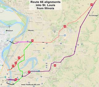
Map of Route 66 through East St. Louis
Click on the Map to see a large sized map showing Route 66 alignments that go into St. Louis MO from Illinois.
This is the color key for this map is the following:
Orange: is first, it shows the original 1926-32 aligment of US66 into St. Louis MO; this one didn't go through East St. Louis.
Pink is the Bypass US-66 that crosses the Chain of Rocks Bridge further north and the Pink line marks its approaches from Hamel.
Green and Yellow are other alignments that went through East St. Louis.
Violet, the latest 1954 alignment from Hamel through Troy to East St. Louis.
Black: missing segments that can no longer be driven.
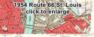
1954 USGS Map of US 66 into St. Louis
Click on the thumbnail map image to see a full size version. Main Route 66 coming from Collinsville (blue arrow right side of the map) reaches the old City 66 from Granite City (now ALT US 67 -green arrow upper right side of the map), it heads toards the Mississippi Rive (blue arrow lower right) crossing the Bridges into St. Louis. On the left-center side US 66 reaches St. Louis and the original City 66 coming from Chain of Rocks Bridge (blue arrow upper left). It turns to head westwards out of St. Louis (blue arrow lower left). You can also see how US 40 and US 66 shared the same alignment into St. Louis.
Below are the maps showing how the Main 66 crossed the Mississipi from East St. Louis.
- Map a Route 66 crossing Eads Bridge
- Map b Route 66 original crossing Martin Luther King bridge
- Map c current access from Route 66 to Martin Luther King bridge
The Route 66 alignment in East St. Louis
Visit our pages with old maps and plenty of information about US 66's alignments.
- Route 66 St. Louis to Gray Summit (next)
- Route 66 Hamel IL to St. Louis MO (In East St. Louis)
- Springfield to Hamel IL (1930-77 previous)
- Springfield to Staunton IL (1926-30 US66 previous)
Route 66 across Illinois
Historic Route 66 has been designated as an All-American Road and a National Scenic Byway in the state of Illinois.
Click for a description of Route 66 in Illinois.
East St. Louis: its classic Route 66 Sights
Attractions & Landmarks
Safety Tips: Be very careful in East St. Louis
East St. Louis is a very unsafe and dangerous area. Avoid visiting this area unless absolutely necessary.
Drug abuse and crime rates are high. Keep off the streets at night. Don't walk around. Keep an eye on your valuables. Know exactly where you are going. Don't get lost or end up in a bad neighborhood.
Neighborhood Scout's crime report reveals that East St. Louis has a very highest crime rate.
Having said this, and considering that most of the historic Route 66 buildings in the city have gone we suggest (at your discretion and caution) to avoid the first alignment to the Municipal Bridge that runs along 10th Avenue.
Former Gas Station
We will tour the town driving west from Fairmont City along Collinsville Rd. to your right at 1323 N 9th St. is a former gas station that now is tire shop. You can still see the outline of the pumps island in the paving in front of it.
Former Gas Station in East St. Louis, Illinois
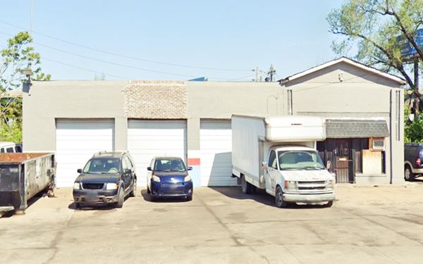
The gable roof is an addition, not part of the original brick structure. Notice the brickwork over the office's windows and the vertical decorations on both sides of the office.
Site of Hillcrest Motel (gone)
Ahead, at 1110 N 9th, on the NE corner with Exchange Ave stood the "Hillcrest Motel" torn down in 2010. Click on image to see more full size images of the old motel at emporis.com.

Ruins of Hillcrest motel US66 East St. Louis MO
Click thumbnail to enlarge. (See St. view)
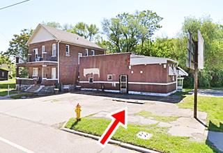
Another old gas station
To your left at 1000 N 9th St. next to a two-story red-brick gable roof house is a former gas station, the service bay on the left side has been walled in, the concrete pumps island and the base of the station's sign can still be seen (red arrow in the image above).
Welcome to East St. Louis billboard
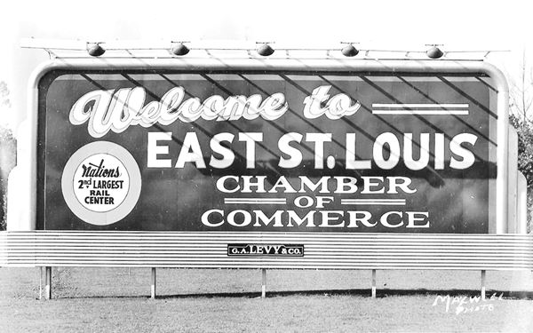
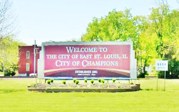
Ahead, after crossing I-64, to your left along St. Clair Ave. in a park is the current "City of Champions" billboard. The original streamline-moderne sign has stood here for decades, with different texts written on it over the course of the years. Back in the 1940s (pictured below), the sign proclaimed that the city was "Nations 2nd largest rail center".
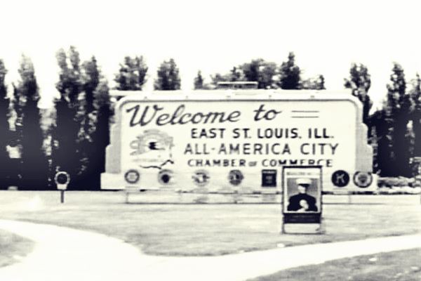
As you can see below, by 1959 it had changed, and proclaimed that it was an "All-America City", named by the National Civic League to honor its civic excellence and the cooperation between citizens, government and businesses. Sadly, the downward spiral of urban decay had already began.
Same spot, but the billboard's text has changed:
The original alignment of N 9th was moved slightly when the bridge was built across the freeway. At St. Clair Ave, turn right, and then left along Collinsville Ave. This is the original Route 66 alignment.
The city looks as if it had been bombed, empty lots of land and solitary decaying red brick buildings, most of them boarded up.
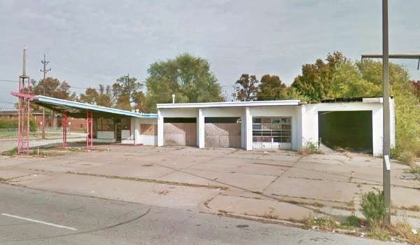
At Martin Luther King Ave. take a left and on the block following the railroad grade crossing, to your left is a Gull Wing gas station:
Gull Wing station
601 Martin Luther King Dr. on the SW corner with N 6th St.
This is a former Phillips 66 gas station from the 1960s. At that time, Phillips Petroleum Co. standardized their filling stations across the US, adopting a modern design.
This consisted of a triangular "gull-wing" canopy which was supported at its narrow tip by a pole designed to look like an oil derrick. The pole was capped with a Phillips 66 revolving sign.
Gull Wing station in East St. Louis, Illinois
> > Learn more about Phillips 66 Gull Wing stations on Route 66
Retrace your steps to Collinsville Ave. turn right and, one block east, closer to downtown, to your left is a Historic Movie Theater:
Historic Majestic Theater
Listed in the National Register of Historic Places
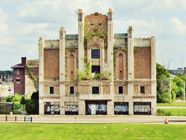
At 240 Collinsville Ave. The historic Majestic Theatre is a movie theater built in 1928 in Spanish Gothic style. It could seat over 1,750 spectators and its first owner was Harry Redmon (the postcard below is captioned "Redmon's Million Dollar Majestic Theater". The facade is tiled with patterns. It was the first in town to have air conditioning but it closed in the 1960s.
It was designed by two brothers, Carl Boller (1868-1946) and Robert O. Boller (1887-1962) who had also designed another Route 66 theater, the Kimo Theater in Albuquerque NM.
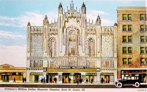
Historic Majestic Theater in East St. Louis, Illinois
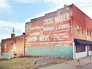
Ghost Sign
Don't miss the Ghost Sign on the red-brick wall of the next building advertising "Chas Mauer Hardware & Stoves".
A ghost sign is an old hand-painted advertising sign that has survived the ravages of time. These signs were popular in the late 1800s.
Broadview Hotel
Listed in the National Register of Historic Places
At Broadway turn left. On the next street, at 415 E. Broadway on the SE corner with Barack Obama Ave. is a classic hotel.
It was built in the boom period that preceded the Great Depresion, in 1927. In the mid 1940s it rented rooms as apartments and in 1957 leased a floor to the Southern Illinois University, by 1978 the University owned the whole building but left it in 2004. Since then it has been vacant. It is being redeveloped by the City of St. Louis, its current owner. It is the work of Arthur J. Widmer. Below is a "Then and Now" set of images:
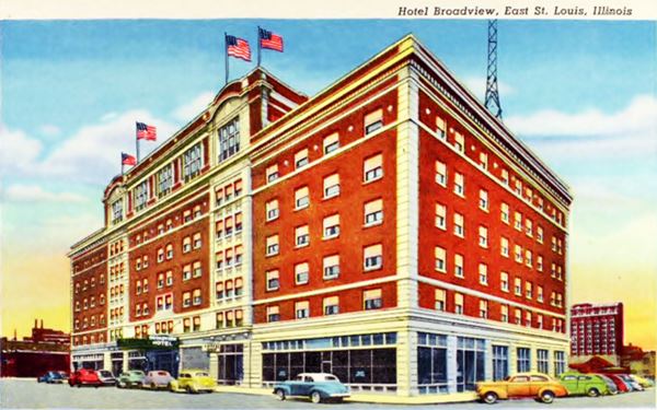
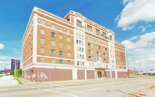
East St. Louis Holiday Inn
One block south, on the SE corner of 5th and Broadway is the site of a Holiday Inn. The motel, now in ruins, was built in the late 1960s. Its amenities included a swimming pool and restaurant with cocktail lounge. Its "Now and Then" photos are shown below:

East St. Louis Holiday Inn, East St. Louis, Il. Credits
In the image above you can see a newer sign (not the original Holiday Inn one), faded with the words "City Centre" on it. To the right of the picture is the old motel, and on the left in the distance, the Broadview.
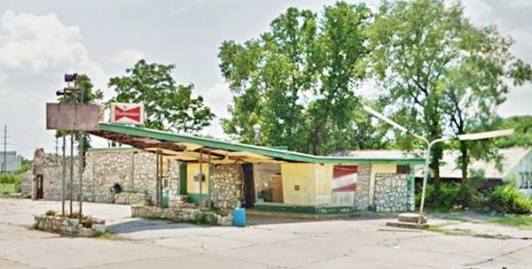
Another Phillips 66 Gull Wing station
Facing the old motel across the street, on the SW corner of Broadway and 6th St.
This late 1950s Phillips 66 Gull wing is clad in stone, which gives it a curious appearance:
Another Gull Wing station in East St. Louis, Illinois
Visit the final sight in town, just barely 1.4 miles away (this is the Map with directions):
Sponsored Content
Malcom W. Martin Memorial Park
At 185 W. Trendley Ave., facing the Mississippi River. It is open 7 AM to 10 PM, 7 days a week, 365 days a year.
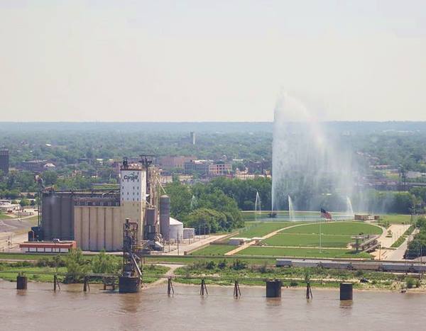
Gateway Geyser
May to September (Memorial Day to Labor Day) Daily eruptions at noon, for 10-minutes. It hibernates the rest of the year.
It is the tallest water fountain in the US and second tallest in the world with a rise of 630 feet (192 m) which matches the height of the Gateway Arch, across the river in St. Louis MO. It opened in 1995 as a landmark on Illinois' riverfront that complements the Gateway Arch in Missouri (you can see it across the Mississippi River).
It blasts 7,500 gallons of water per minute (28,125 l).
The Mississippi River Overlook
It is 40 ft. tall (12 m) and is located at the western end of the park. It gives you a great view of the Mississippi River, St. Louis, its skyline, and the Gateway Arch.
Gateway Geyser in East St. Louis, Illinois
From the park you can reach Eads Bridge (Map with directions) and use it to cross the Mississippi, into Missouri.
Eads Bridge
Listed in the National Register of Historic Places
It was named after its designer and builder, James Buchanan Eads. It is very old, built between 1867 and 1874. Eads was the first bridge across the Mississippi south of the Missouri River. It is an arch bridge with a total lenght of 6,442 ft (1,964 m).
It has three steel arches and is almost 46 feet wide (14 m).
It carried Route 66 together with neighboring MLK bridge. The automobile deck was closed between 1989 and 2003 for repairs.
This marks the end of this leg of your Route 66 road trip in Illinois and East St. Louis, continue westwards in St. Louis Missouri.

Sponsored Content
>> Book your Hotel in Chicago

Credits
Banner image: Hackberry General Store, Hackberry, Arizona by Perla Eichenblat


