
"Horseradish Capital of the World"
The Largest Catsup Bottle in the whole World

Index to this page
About Collinsville, Illinois
Facts, Trivia and useful information
Elevation: 500 ft (152 m). Population 25,579 (2010).
Time zone: Central (CST): UTC minus 6 hours. Summer (DST) CDT (UTC-5).
Collinsville is a city partly located in Madison County and partly in St. Clair County close to the Mississippi River in Southwestern Illinois.
History of Collinsville
What is now Illinois has been inhabited for at least 12,000 years, since the end of the last Ice Age. Here you can learn more about Collinsville early history.
The first settler of what is now Collinsville, was John Cook around 1810. The founders of the city were the Collins family from Litchfield, Conn., who arrived in 1817 and purchased the holdings of Mr. Cook.
Augustus, Anson, William B. and Michael Collins arrived first followed five years later by their father, Deacon William Collins, their youngest brother, Frederick.
Trivia: Horseradish Capital of the World
The German immigrants brought horseradish with them when they settled as farmers in this area. Nowadays, their descendants produce more than 5,000 tons of these radishes each year.
Collinsville sponsors an annual Horseradish Festival during the first weekend in June at Woodland Park (Route 159).
Originally called Unionville when a postoffice opened in 1825 the postmaster general changed the name to Collinsville, because there already was a Unisonsville post office in the state.
The town plat of Collinsville was laid out by 1837. Its incorporation as a village took place in 1850, and was organized as a city in 1872.
Coal was mined from 1857 to 1964. By the 1950s it was a bedroom community of St. Louis. And it was then that a new alignment of US 66 was built from Hamel through Collinsville and Fairmont City into St. Louis.
The Name:Collinsville
From the founding family's surname "Collins". The Irish form has been Anglicized form of Gaelic Ó Coileá and the English name comes from Colin, diminutive of Coll which in turn is a shorf form of Nicholas (after Saint Nicholas).

Getting to Collinsville
Drive to Collinsville using Historic Route 66 or by the freeways (I-55, I-64 and I-255, I-70 or I-270). US 40 and State Hwy 159 go through the town.
Hotels and Motels: Collinsville, Illinois
Accommodation and hotels in Collinsville
> > Book your accommodation in Collinsville
More Lodging near Collinsville along Route 66
Below you will find a list of some of the towns along Route 66 east and west of this town; click on any of the links to find your accommodation in these towns (shown from east to west):
Along Route 66 in IL
- Hotels in Illinois
- Route 66 Starting point ▸ Chicago
- Lockport
- Willowbrook
- Bolingbrook
- Plainfield
- Romeoville
- Joliet
- Wilmington
- Dwight
- Pontiac
- Chenoa
- Normal
- Bloomington
- Atlanta
- Lincoln
- Springfield
- Raymond
- Litchfield
- Staunton
- Williamson
- Hamel
- Edwardsville
- Collinsville
- Troy
- Glen Carbon
- Pontoon Beach
- Granite City
- East St. Louis
West in Missouri
- Hotels in Missouri
- Florissant MO
- Bridgeton MO
- St. Louis MO
- Kirkwood MO
>> Check out the RV campground in neighboring Granite City
Weather in Collinsville

Location of Collinsville on U.S. Hwy. 66
The average temperatures in Collinsville during Summer (Jul) are around 90°F (32.2°C) - high, and 70°F (21.1°C) - low. While the winter averages are (Jan) 36°F (2.2°C) and a chilly 19°F (-7.2°) respectively.
Rainfall his fairly even throughout the year with peaks of 4.2 inches in April and May. With a minimum of 2 inches (51 mm) in January. Expect snow, ice and sleet in winter. Best weather in spring./p>
Tornado risk
Collinsville may be hit by some 7 tornados every year. Tornado Risk: read all about Tornado Risk on Route 66.
Map of Route 66 through Collinsville
Map of US66 in Collinsville.
Click on the Map to see a large sized map showing Route 66 alignments that go into St. Louis MO from Illinois.

Map showing Route 66 from Illinois into St. Louis MO
Click on Map to Enlarge
The following color key applies to this map:
Orange: is first, the original 1926-32 aligment of US66 through St. Louis
Brown is the Bypass US-66.
Green, The other colors (Pink and Yellow) show different courses taken by US 66 over the years.
Violet marks the 1954 alignment through Collinsville.
Black: missing segments.
The Route 66 alignment in Collinsville
Visit our pages with old maps and plenty of information about US 66's alignments.
- Route 66 St. Louis to Gray Summit (next)
- Route 66 Hamel IL to St. Louis MO (In Collinsville)
- Springfield to Hamel IL (1930-77 previous)
- Springfield to Staunton IL (1926-30 US66 previous)
Route 66 Sights in Collinsville
Landmarks and Places to See
Sponsored Content
Attractions: Drive along Route 66
Jack Rittenhouse does not mention Collinsville the "Guidebook to US 66" he published in 1946 because at that time the alignment through the town didn't exist. And he drove along the bypass alignment from Mitchell west, across the Chain of Rocks Bridge and then along BYP 66 north and west of St. Louis.
Start your drive in the east, coming from Hamel, The 1954-1977 Route 66 alignment is now part of I-55. At that time US66 from Hamel to Troy was a two-lane highway. It met US40 at the place where the modern junction of I-55 & 70 with US 40.
Route 66 met US 40 and turned west. At the junction you can still see a stretch of the original eastbound lanes of US 66 before they turned north, see this Satellite view of the old roadbed.
Both US 66 and US 40 headed west as a divided highway with four lanes. The original lanes are now under the freeway, but the westbound ones resurface at Canteen Creek on the north side of the interstate, as a curve on Troy Rd. (map of this segment).
At Troy Crossing the four lane highway became a two-lane one, as it met IL-159 next to where the water tower is not located on the SE side of Exit 158, where Vandalia St. meets Troy Rd.
It curved following Vandalia St., heading south west together with IL-159. Modern IL-159 north of E. Country Ln. didn't exist, instead it followed old Vandalia St. The old alignment is cut off at E. Country Ln. but the roadbed to this point still exists (see map).
Lowell's Service Station
To your left, at 2000 Vandalia St. is an oblong box gas station with a three bay garage and a corner office with large plate glass windows. The original building, only had two garage bays, and it lacked the canopy, which is a modern addition.
In the 1970s it was a Mobil service station, in the 1980s it was Al Tognarelli's Mobil. Below is a "Then and Now" picture sequence.

Vintage picture Lowell's garage. Source

Current view of Lowell's Mobil. Click for St. View
Ahead Route 66 turns west (right) along Beltline Rd. But first, take a short side trip to see the best known attraction in Collinsville, the Giant Catsup Bottle, an example of Kitsch and Americana, the Brooks Catsup Bottle Water Tower.
Historic Brooks Catsup Bottle Water Tower
Listed on the National Register of Historic Places - Americana & Kitsch
State Hwy 159 and Railroad Ave, Collinsville, just 2.2 miles south along IL-159, see Map with directions.
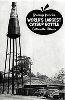
Standing 170 feet-tall (52 m) this water tower shaped like a ketchup (or catsup) bottle is said to be the world's largest catsup bottle.
In 1907, the Brooks brothers, Elgin and Everett acquired a local canning plant. They named it Triumph Catsup and Pickle Co. but it later became the Brooks Tomato Products Company.
The Brooks Catsup Bottle Water Tower in Collinsville, Illinois

Business was great and in 1949 the World's Largest Catsup Bottle was completed atop their plant, as an advertising for their leading product.
After merging with P.J. Ritter Co. in the 1950s, the catsup bottling was moved to a plant in Indiana in the 1960s. The factory became a warehouse. Though deeded to the city, it is now conserved by a the Catsup Bottle Preservation Group.
Learn more a their www.catsupbottle.com

1940s photo of the catsup water tower. Source. Click for same view nowadays.

USGS 1953 map showing old gas station (arrow), Collinsville.
Turn around and head back to Beltline Rd. and IL-159, there are two landmarks on your return trip.
Oatman's House
At 501 E Main St., two blocks to your right in downtown Collinsville. This historic home is now a restaurant, but in the 1800s was the home of Dr. Charles Oatman, who was related to Olive Ann Oatman (1837-1903) who was held captive for five years by the Mohave Indians. The town of Oatman on Route 66 in Arizona, is named after her.
War Memorial Monuments
Just ahear, youo can stop at the American Legion Post 365 (1022 Vandalia St.) to your right. It has a park with monuments in memory of those who who served and died in wars defending America and freedom. It has a AH-1F Huey Cobra chopper and a 105 Howitzer.
Turn west (left) along Belt Line Rd. and just ahead, to your left is another Old Service Station, yellow arrow in map above.
Former Service Station
420 Belt Line Rd, Collinsville. Nowadays it is a garage and repair shop. But it was a gas station back in the 1950s. See the original sign post on the corner, and the two door garage plus the square lines of a classic gas station.
Former Service Station in Collinsville, Illinois

Belt line Rd. went through open countryside, the city lay to the south, it was a "Beltline" highway, bypassing the congested downtown area. To the west it curved south to meet IL-157. All of the motels, gas stations and restaurants along this road section have been torn down, except for one, at its southern tip.
Evergreen Gardens
Turn left along IL-157 and head south for 1.9 miles (Map), to your left is an old restaurant that now became a church.
It was a restaurant with rooms for weddings, banquets and private parties, specializiing in steaks and dinners. It had "Dancing Nightly and Sunday Afternoon" on "Route 40 at the foot of Collinsville Hill".
The building is still standing, in good shape and unchanged as you can see in the "Then and Now" images below.


Take a very short detour to visit a classic gas cottage style station.
Old gas station, Eck Auto
400 Caseyville Rd, Collinsville, barely 0.8 miles from Route 66, see this map with directions.
It is a Cottage Style Gas Station from the late 1920s. Located close to where Caseyville Rd. meets St. Louis Rd. It has been Eck Auto Service since 1958. The gabled roof, canopies and chimney are of a style that was popular at that time when service stations had to blend into their urban surroundings. It may have been a Phillips 66 station.
Old gas station, Eck Auto in Collinsville, Illinois

Monks Mound
Retrace your steps and head west along Collinsville Rd. along the 1954-1977 alignment of Route 66 in Collinsville. Two miles west, at Collins Ln. turn right and park. (map) to visit "Monk Mound", just to the south, along Ramey St. is the entrance to "Cahookia Mounds". Both sites are a must-see landmark.
Follow the trail and climb the mound. You can also see it from the highway.
Monks Mound, the largest man-made earthwork in North America.
The image shows Monks Mound, at Cahokia Mounds. This Mound is larger at its base than the Great Pyramid of Giza in Egypt (it covers 14 acres at the base - 5.66 ha. and is 100 feet high - 30.5m).
It is the world's largest man-made prehistoric earthen mound and is part of the Cahokia Mounds World Heritage Site, whose entrance is on the southern side of Route 66.
Monks Mound, Route 66 to the lower left of the image, Collinsville, Illinois

Cahokia Mounds World Heritage and State Historic Site
World Heritage site of UNESCO
Collinsville Rd. and Ramey Rd.
This area was a vast Native American settlement. Its population of around 20 to 30,000 made it the largest Pre-Columbian settlement north of Mexico. Its population wasn't surpassed by any city in the US until after the 1800s.
This site protects over 70 mounds. There is also a reconstructed "Woodhenge", a museum, and visitors' center.
The mounds were built between around one thousand years ago (AD 900 and 1200) by Native Americans of the Mississippian Culture. The complex originally covered 6 sq.mi (1,600 ha.) and included about 120 mounds of different sizes and shapes.


They were built by sheer manpower, there were no beasts of burdens or carts, all the earth was carried by hand!
Learn more at the sites website cahokiamounds.org
Woodhenge
Ahead, also on Route 66 is "Woodhenge" (map). Discovered in the early 1960s, it was a series of circles with pits into which 12 to 60 sacred cedar posts were set up, to mark the seasons following the position of the rising sun. Five separate sites were found and date back to 900-1100 AD.
The third circle which is 410 feet in diameter (125 m) was built in 1000 AD, and was reconstructed in 1985 at the original location. It has 48 posts (20 feet high and 20 inches diameter (6 m and 0.5 m respectively).
Former Drive In Theater
Between the mounds and Woodhenge, on the south side of Route 66, to your left, is the Site of a former Drive in theater. A great example of America, ancient and modern side by side.
Collinsville Rd. (Map). The former Drive In is gone, but it has left its imprint in the terrain and the vegetation. See below, Red arrows.

USGS Map (1954) showing Drive In Theater

Satellite view of old Drive In Theater. Click for St view
This is the end of your road trip through Collinsville but you can head west into St. Louis and visit the towns on the final segment of Route 66 in Illinois as you approach the Mississippi River.
Sponsored Content
>> Book your Hotel in Chicago
Credits
Banner image: Hackberry General Store, Hackberry, Arizona by Perla Eichenblat