Route 66 in Crestwood, Mo
Index to this page
- About Crestwood
- Crestwood's Weather
- Hotels and accommodation
- Map of US 66
- What to see and do in Crestwood
About Crestwood Missouri
Facts, Trivia and useful information
Elevation: 620 ft (189 m). Population 11,912 (2010).
Time zone: Central (CST): UTC minus 6 hours. Summer (DST) CDT (UTC-5).
Crestwood is a city located on the 1932-1977 Route 66 in St. Louis County, central-eastern Missouri.
History of Crestwood
This part of Missouri was peopled some 11,000 years ago at the end of the last Ice Age. There are some earth mounds in the region (at Fenton and across the Mississipi in Illinois), built by Native Americans around AD 1050 - 1400.
In historic times, the French exporers from Canada reached the region in 1683 and met natives of the Algonquin nation who called themselves "Illiniwek" or "men" in their own language. These hunter-gatherers grew corn, squash and beans. The French corrupted their name to "Illinois".
The French named the land after their King, Louis IV: "Louisiana" and in 1764, Laclede and Chouteau founded St. Louis; white settlers arrived shortly after. After losing the territory to Spain in 1762, the French recovered it in 1801 and needing cash, quickly sold it to the United States in 1803.
Shortly after, in 1805, Thomas Sappington settled there and built his home here in Crestwood (see Sappington House), and their Sappington Cemetery dates back to 1811, probably the oldest cemetery on Route 66.
St.Louis incorporated and became a municipality in 1809. The Territory of Missouri was created in 1812, and it became a state of the Union in 1821. In the 1830s the Native Americans were relocated to reservations in Oklahoma. Ulysses Grant, who later became the 18th President of the U.S., lived in Crestwood from 1854 to 1859; his home is the Ulysses S. Grant National Historic Site. This was a rural community with farms.
After the Civil War Crestwood grew slowly. The original post office was named Sappington. Neighboring Webster Groves had a post office since 1867 and was named after Webster College. Watson Road dating back to the late 1800s was named after Wesley Watson who owned a sand and gravel pit used in construction. Route 66 was aligned along it, and a "New" Watson Rd. built in 1932.
The Name: Crestwood
The name came from a tree that stood on the "crest" of a hill on a street named Crestwood. Another version says that the Crestwood Subdivision of the township sought was named after an old white oak tree on Diversey Lane.
After World War II, St. Louis suburbia grew as the veterans bought their homes in its outskirts. Crestwood was quickly developed and subdivided, it incorporated as a city in 1947 to avoid annexation by neighboring Oakland. The post office was renamed Crestwood in 1947.

Hotels and Motels: Crestwood, Missouri
You can find accommodation and hotels close to Crestwood:
> > Book your accommodation in the area:Bridgeton, St. Louis, or Kirkwood
More Lodging near Crestwood along Route 66
There are several hotels in the area close to this town. Alternatively you can also find your accommodation along Route 66 in the neighboring towns and cities in Missouri. We list them below (from east to west):
On Route 66's Main alignment in MO
Eastwards
Westwards
- Hotels in Kansas
- Baxter Springs KS
- Galena KS
- Riverton KS
- Hotels in Oklahoma
- Miami OK
>> Check out the RV campground in neighboring Fenton
Weather in Crestwood
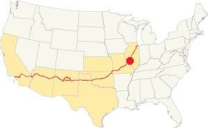
Location of Crestwood on U.S. Hwy. 66
Crestwood has four well marked seasons. It is located in the area where humid continental climate shifts towards a humid subtropical climate, so summers are hot and humid while winters are cold. It gets cold Arctic air and hot damp tropical air from the Gulf of Mexico. Spring is wet and may have extreme weather (tornados, thunderstorms and even winter storms). Fall is sunny and less humid, with mild weather.
The average high in winter (Jan) is a cool 39.9°F (4.4°C) while the average low is a chilly 23.7°F (-4.6°C). The summer (Jul) average high is 89.1°F (31.7°C) and the average low is 71°F (21.7°C).
Rain is on average 41 in. (1.041 mm) with the rainiest months being May through July with over 4.1 in monthly (104 mm). Snow falls between Nov. and April with a total snowfall of 17.8 in. (45 cm). Relative humidity is around 70% and is fairly stable year round.
Tornado risk
The town is located in Missouri's "Tornado Alley" and St. Louis County is struck by some 7 tornados every year.
Tornado Risk: read more about Tornado Risk along U.S. 66.
Map of Route 66 in Crestwood Missouri
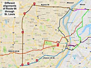
The map shows Route 66 in the St. Louis Region in both Missouri and Illinois. The color key for the map is the following:
Orange: is first, the original 1926-32 alignment of US-66 through St. Louis
Brown is the Bypass US-66.
Pale Blue: Is the Historic Route 66 alignment after 1932 into St. Louis, from the west. Crestwood is along this alignment (lower left).
Blue, Green, Gray, Pink, Yellow, and Violet show different courses taken by US 66 over the years.
Black: missing segments.
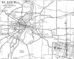
The following map from 1955 shows Route 66 in St. Louis vicinity. Crestwood is located on the south side, along Wastson Rd. on "City 66".
The original 1926 to 1932 alignment of U.S 66 west of ran to the north of Crestwood, through Kirkwood along Manchester Rd. and therefore avoided crossing the Meramec River in Sunset Hills.
The 1933-1977 Route 66 was aligned to the south along Watson Rd. which was paved in 1932, through Crestwood; this is the alignment along Watson Rd. in Crestwood: map.
The Route 66 alignment in Crestwood
Visit our pages with old maps and plenty of information about US 66's alignments.
- Gray Summit to Rolla (next)
- Route 66 St. Louis to Gray Summit (In Crestwood)
- Route 66 Hamel IL to St. Louis MO (previous)
Route 66 Sights in Crestwood
Landmarks and Places to See
66 Auto Court site
Begin your drive heading westwards along Watson Rd (Route 66), coming from Marlborough. Ahead, at 8730 Watson Rd. to your left was "St. Louis’ Finest Modern Auto Court." the 66 Auto Court
it closed in the late 1970s and burned in 1981. There is a replica of its classic neon sign at the Chain of Rocks Bridge
The Chain of Rocks Bridge (66 Auto Court motel neon sign is on the left)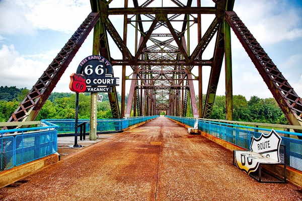
Now take a side trip to visit a historical site, part of American history:
Ulysses S. Grant National Historic Site
National Historic Site
Just 1.5 miles south, at 7400 Grant Rd. (map with directions.)
Admission is Free. Learn more at the Park's website.
The best known Civil War general, who fought for the Union and became the 18th President of the United States, Ulysses S. Grant lived on this 80-acre plot of land gifted to him by his father-in-law, Frederich Dent when he married Julia Dent in 1848. The couple lived here till 1859.
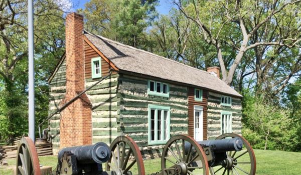
Grant's log cabin
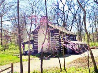
Grant built his log cabin here, and called it "Hardscrabble"; it was moved around quite a bit during the next 50 years (it was on exhibition at the Saint Louis World Fair of 1904, as an advertisment of the Banke Coffee Co. Augustus Busch (of the Anheuser-Busch beer company) bought it and returned to the farm, but not to its original location; it is 1 mile away, at Grant's Farm another local attraction; see below.
You can see the cabin from the street (see location map).
Grant's Farm
Across the street from Grant's Historic Site. The farm is an animal reserve that belongs to Anheuser-Busch; it is a refugee for over 900 animals (from over 100 species, including deer, zebras, and buffalo). The land was once part of Grant's property. It has plenty of attractions including the log cabin built by Grant. More information at their website: www.grantsfarm.com.
William Long's log Cabin (1820)
As you drive back to Route 66, visit another old log cabin at 9108 Pardee Rd. (map with directions)
The cabin was thehome of William Lindsay Long (1789-1849), son of a pioneer and Revolutionary War veteran, John Long. William married Elizabeth Sappington in 1808. He was a surveyor and platted neighboring Fenton in 1818 (he named it after his grandmother). He was also the Postmaster at Sappington (1827).
Drive back to Route 66 to see another ancient site:
Sappington Cemetery
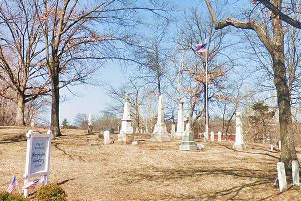
To your right, on a hill on the western bank of Gravois Creek, at 9111 Watson Rd. Location map.
This is probably the Oldest cemetery on US 66, it dates back to 1811. Here are many graves of soldiers who fought in different wars: the Revolutionary War, the US-English War of 1812, the Mexican-American War, and the Civil War.
George Washington's bodyguard, Sgt. John Sappington, a Revolutionary War veteran is buried here.
The "lost" landmarks along Route 66
There are almost no Route 66 landmarks in Crestwood. The growth of modern suburbia and urban development led to the loss of motels, gas stations and even a classic Drive In movie Theater:
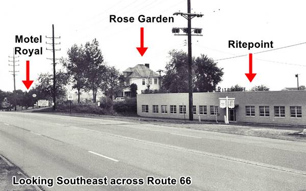
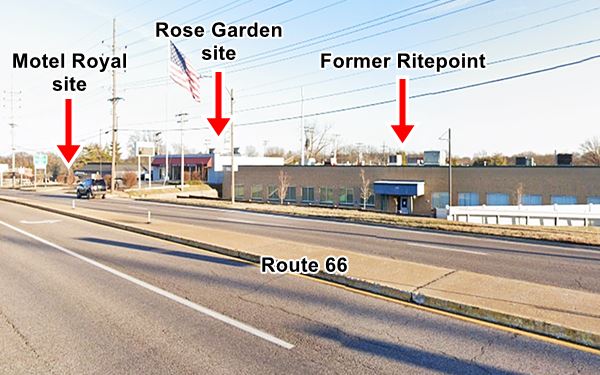
After the Cemetery along Watson Rd. to your left (at 9282, see map) was the Motel Royal, it had 60 units located along a circular drive, far from the highway, with a large grassy central courtyard. It was ran by Carl Catalano, and you can see it in this 1958 aerial photograph. The place was razed in the early 1970s and a large mall stands on the spot (Aldi).
Next to it, to the right, stood the Rose Garden restaurant (9300 Watson), and facing it (9825 Watson) was the Oaks Motel, torn down in 1967. When the Crestwood Plaza expanded east.
Ritepoint Pen Co
Adjacent to the Rose Garden was the Ritepoint Pen Co. founded in 1933 by Sylveser Lipic. They made lighters, pens, pencils, and ballpoints. Lipic sold it in 1954 and the company moved to Fenton as Ritepoint Chromatic Inc. The original building is still standing as you can see in this Then-and-Now set of images, looking towards the southeast across US66:
Just ahead, to your left is the site of the now demolished "66" Park In Theater:
The "66" Park In Theater: now gone
To your left, at 9540 Watson. This is a Map showing its location.
The "66" Park In opened in 1947; at that time it was located in open countryside close to the urban population of St. Louis; it even had a merry-go-round and a Ferris Wheel. But by the mid 1980s, attendance dropped; it was sold in 1988 and remained open until 1993. It was torn down in 1994 and now it is a mall.
Crestwood Plaza (Gone)
Facing the drive-in theater stood the Crestwood Plaza. It opened in 1957 with an open mall layout with several stores including a Sears and a Kroger supermarket. In 1984 it was rebuilt as an enclosed mall. but unable to compete with other neighboring malls, it closed for good in 2013 and was torn down in 2017.
Tobey’s Drive-In
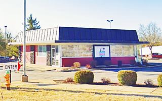
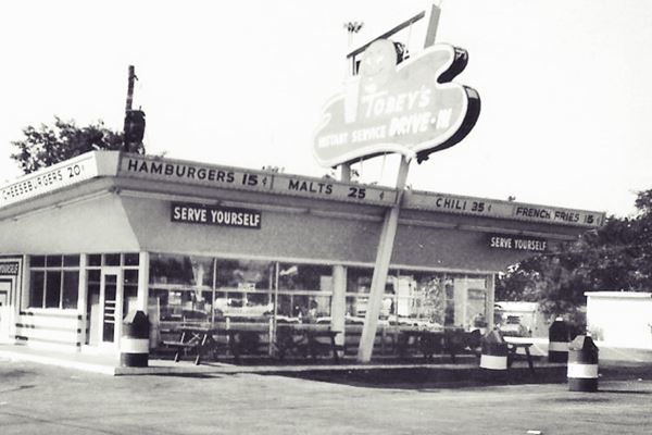
At 9600 Watson, on the SW corner with Old Sappington Rd. Tobey's was the brainchild of Lee R. Toberman. The place started out as "Henry's Serve Yourself Drive In" back in 1958, but Toberman renamed it "Tobey's" a few years later.
He owned a second restaurant nearby, in Rock Hill, both restaurants were the "Home of the Happy Hamburger". The picture below shows it sold cheeseburgers for 20¢ and burgers for 15¢.
Now it is Imo's Pizza. The same building has survived but its roof has been modified.
Sappington House
Historic Site
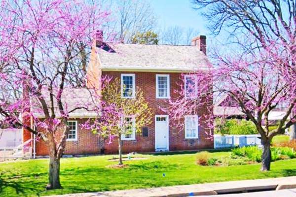
Just ahead, turn right along Sappington Rd, (map with directions) and drive half a mile to visit an ancient yet elegant brick house, in stark contrast with the rough and primitive log cabins visited earlier in your city tour.
Sappington House was built in 1808 and is believed to be the oldest brick house in St. Louis County. Built in Federal style it has period furnishings.
Retrace your steps and drive back to Watson Rd. (Route 66). Turn right. Here, in Kohl's parking lot once stood Wuellner's Gulf station. Facing it, at 9730 Watson (now a kickboxing gym) was the Lone Star Motel with "Central heating and reasonable rates."
The Bel Air Motel was located to your right where the Walgreens is now located. It was torn down in the mid 1980s when the Watson Plaza was built. Another vanished classic is Clark's gas station (at 9804), followed by the surviving bowling alley:
Crestwood Bowl
Americana - Bowling Alley
9822 Watson Rd.
It opened in 1958 and was ran Dick Weber, Rich Volling and Pat Paterson.
It has always been a bowling alley. Ray Bluth (born 1927), a PBA Hall of Fame inductee bought it in 1973 and nowadays it is
run by his son Mike. It has 24 bowling lanes and a lounge plus a snack bar. Don't miss its fantastic neon sign (pictured below).

David Lee Roth and Eddie Van Halen by Crestwood's McDonald's arch in 1978 Route 66 Crestwood. Photo by Richard Upper
McDonald's of Van Halen Fame
Continue west along Route 66, to your right, at 9915 is a McDonlad's that opened in 1958, the oldest McDonald's in Missouri; it had the typical design of that period with two arches on each side of the building. It was the 71st restaurant in the chain.
Its claim to fame is the photograph taken in 1978 depicting Eddie Van Halen (1955-2020) and David Lee Roth (b. 1954) next to the golden arch of this store.
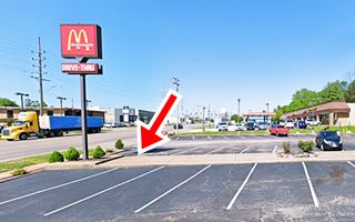
They visited Crestwood's KSHE 95, a rock FM station that was a few blocks away from this restaurant. Van Halen played in the St. Louis Opera House in April 1978. Below is the same site nowadays, the spot where the photo was taken is marked with a red arrow; a modern sign stands on the spot.

Eddie Van Halen, David Lee Roth, and Site & Shell gas stations on Route 66 in 1978. Crestwood MO. Photo by Richard Upper
Site and Shell gas stations
In the picture above you can see some "vanished" landmarks (see detail in inset image) such as the Site Gas Station (red arrow), a local St. Louis brand, a Circle K station was built on the premises.
Further away is the old Shell gas station (9945 Watson) the sign and ranch-style building are marked with blue arrows. It was torn down in 2008 and the Simmons bank stands on the property. Before being a Shell it had been Sander's Sinclair.
Conroy’s Tourist Rooms was located at 9920, opposite the McDonald's it was owned by Edward Conroy at least from 1953 into the early 1970s. It had cabins.
Il Vesuvio
Just ahead, at 9942 Watson, to your left, across Route 66 was the Italian restaurant Il Vesuvio, it had a neon sign that displayed an erupting volcano (Vesuvius) and operated from the mid 1950s to the mid 1970s. Now it is part of the Rich & Charlie's Italian Restaurant chain. Previously it had been Krabbe's Grill, Decker's FineFoods and Vieksang's Tavern.
Next to it was the Blue Haven Motel (10000), torn down in 1975, and facing it the Chuck-A-Burger at 9955. The 66 Trailer Court at 10024 Watson and
Froesel Tire Service

Froesel Tire Shop then and now. Source. Click image for St. view
To your right is a surviving building, formerly Froesel Tire Service at 9965 Watson, the oblong box flat-roof structure with a glazed corner office with transom windows and door, and a twin service area now has a new taller facade added to the office, but the building is clearly recognizable as you can see in the "Then and Now" sequence.
Next to it is a red-brick two-story building, formerly Crestwood Boats and Motors now an appliance store.
The Blue Bonnet Court was at 10100, Vi-Don Motel atg 10150,
and the Twin-Six Motel at 10230 Watson Rd.
This segment of your Route 66 road trip in Crestwood ends here; drive west into Sunset Hills to continue your journey.

Some sponsored content
> > Book your Hotel in Lebanon

Source
Banner image: Hackberry General Store, Hackberry, Arizona by Perla Eichenblat
Jack DeVere Rittenhouse, (1946). A Guide Book to Highway 66.
The Ramsay Place Names File


