Route 66 in Sherman IL
Index to this page
Sherman, Illinois: all about it
Trivia, Facts and Useful Information
Elevation: 598 ft (182 m). Population 4,603 (est. 2022).
Time zone: Central (CST): UTC minus 6 hours. Summer (DST) CDT (UTC-5).
Sherman is a village in northern Sangamon County, Illinois. Located on Historic Route 66.
The History of Sherman
Central Illinois was peopled when the glaciers retreated 11,000 years ago. Later the Pottawatomie, Kickapoo, Tamaroa, and Delaware Indian tribes would live in the area.
Settlers arrived in the early 1800s to this area that at that time was known as Grasshopper (according to a local tale due to the large numbers of grasshoppers living there and James Sayles built a home on the current site of Sherman in 1819.
The town was platted by four men who in 1858 purchased 80 acres of land belonging to the Wigginton estate. They later sold it to settlers. They were real estate developers who profited from the construction of the Chicago & Alton Railroad that was built through the area at that time.
The name: Sherman
David S. Sherman (1812 - 1871) was one of the four businessmen that bought 80 acres of land here and platted the town. His name was drawn from a hat which held the names of the four partners. The town was named after him.
Sherman as a surname comes from an occupation, and it means "shearer of woolen garments", it comes from the Anglo-Saxon words "scearra" or "shears" "Mann" or "man".
The town had a large Italian population in the 1900s and most of them worked in the local coal mine.
Route 66 was aligned through Sherman in 1926 following the path of Illinois state highway 4 and remaind so until it was de-certified in 1977.

Hotels and Motels near Sherman
There are plenty of accommodation options on Route 66 in neighboring Springfield so you won't have difficulty to book your room in that city:
> > Book your Hotel in Springfield
More Lodging Near Sherman along Route 66
Below you will find a list of some of the towns along Route 66 east and west of this town; click on any of the links to find your accommodation in these towns (shown from east to west):
Along Route 66 in IL
- Hotels in Illinois
- Route 66 Starting point ▸ Chicago
- Lockport
- Willowbrook
- Bolingbrook
- Plainfield
- Romeoville
- Joliet
- Wilmington
- Dwight
- Pontiac
- Chenoa
- Normal
- Bloomington
- Atlanta
- Lincoln
- Springfield
- Raymond
- Litchfield
- Staunton
- Williamson
- Hamel
- Edwardsville
- Collinsville
- Troy
- Glen Carbon
- Pontoon Beach
- Granite City
- East St. Louis
West in Missouri
- Hotels in Missouri
- Florissant MO
- Bridgeton MO
- St. Louis MO
- Kirkwood MO
>> Check out the RV campgrounds in Springfield, Lichtfield, and also in Raymond
The weather in Sherman
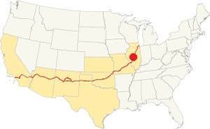
Location of Sherman on U.S. Hwy. 66, Illinois
Sherman has a humid continental climate: hot, humid summers and cool to cold winters.
The average high for winter (Jan) is 34°F (1 °C); the average low for winter is 18°F (-7.8 deg;C). The summer average high (Jul) is 85°F (29.7°C) and its low is 65°F (18.1°C).
Precipitation is lowest in January (1.93 in. - 49 mm) and peaks at 5.08 in July (129 mm). Yearly rainfall is 36.7 in ( 1008 mm). Snow falls from November through March and averages 22 inches (55 cm).
Tornado risk
There are some 7 tornado strikes per year in Sangamon County (where Sherman is located). Tornado Risk: learn more about Tornado Risk on US 66.
Map with the alignment of Route 66 through Sherman
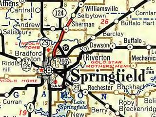
Roadmap of Springfield in 1946. Sherman is above. Source
Click thumbnail map to enlarge
See our custom interactive maps of Route 66 near Sherman:
The thumbnail map (click on it to enlarge), shows Route 66 with a red line: a four-lane highway from Springfield northwards throught Sherman towards Selbytown.
Air view of Route 66 in Sherman from 1970
The 1970 air view of Sherman looks south towards Springfield and shows the different alignments of Route 66 in the area:
Aerial photograph (1970) of Sherman, Illinois
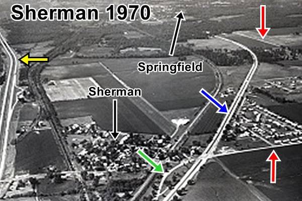
The 1926 alignment is marked by the Red Arrows and the 1926 alignment through the Wayside Park with the Green Arrow; the later (post 1936) alignment which became a four-lane divided highway in 1940 is shown with a Blue Arrow. To the left, behind Sherman is the Freeway (I-55) marked with a Yellow Arrow. Springfield is in the south (upper side of the image).
The Route 66 alignment in Sherman
Visit our pages with old maps and plenty of information about US 66's alignments in this area.
- Springfield to Staunton IL (1926-30 US66) south from Springfield (next)
- Springfield to Hamel (after 1930) south from Springfield (next)
- Pontiac to Springfield (Sherman's)
- Chicago to Pontiac (previous)
Sherman: classic US 66 Sights
Landmarks and Attractions
Historic Context
Jack Rittenhouse drove the whole length of Route 66 and wrote the classic "Guidebook to U.S. 66", which he self-published in 1946. He mentions Sherman as follows: "Pop 100... gas; Withrow Garage; grocery. Here begins a 5-mile stretch of divided highway... where the new freeway is being completed."
Not much remains of those landmarks, however, the divided highway survived as Sherman Blvd.
Begin your trip coming from the north (westbound from Williamsville); since Route 66 was overlaid by I-55 in this area, use the freeway to reach Sherman and take e Exit 105. When you reach Sherman Blvd., take a left and head north to Wolf Creek Rd. to visit the abandoned roadbed of the 4-lane US 66.
Abandoned lanes 1940s US66
The four-lane alignment built in the 1940s runs northwards from Sherman and can be driven in both directions until you reach Wolf Creek Road. Here the former southbound lanes are abandoned (see image below) while the northbound ones are still in use because they link with the freeway just ahead (where all of the four-laned US 66 northwards is now covered by I-55 north into Williamsville).
This is a Satellite view of it (abandoned lanes to the left).
"Old" lanes of US 66 north of Sherman, Illinois
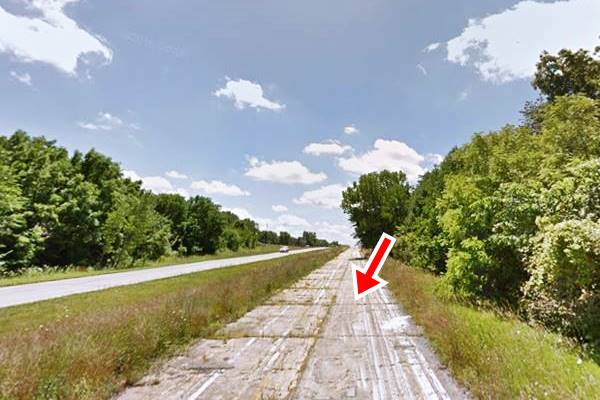
Drive to Wolf Creek Rd. and the "Road Closed" signs will mark the old lanes. Don't continue north because you will end up on I-55 with no Exits until Williamsville. Turn around and head south along Sherman Blvd. As you reach Sherman, to your left is an old Wayside park with an original segment of the 1926 alignment of US 66:
Wayside Park
On the NE corner of Sherman Blvd. and E. Andrew Rd.
When cars were slow and didn't have air conditioning, traveling by car in summer was a tiring, dusty, and hot business. So wayside parks like this one were built. They had picnic areas and trees where weary travelers could stop and freshen up.
Sherman's wayside park has survived until our days, now it is the "Route 66-Veterans park" and it has the added bonus of two preserved a section of the original 1926 roadbed.
Notice in the satellite view further down, the two segments that have survived (red arrows) and the original alignment that curved west along E Andrew Re (dashed red line).

Satellite view of the southern part of old Route 66 alignment, Sherman, Il. Click for Satellite view
The road had two lanes and was narrow. Each lane was eight-feet wide and they were built in 1922 in Portland cement 6 inches thick, with four foot wide gravel shoulders.
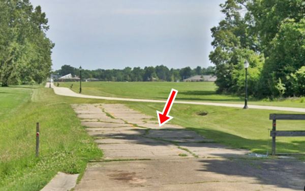
There are two sections, one to the north that is 335 feet in length, and one to the south, 440 feet long. A drainage channel separates the two sections of the roadway.
In this aerial photo from 1956 you can see both alignments (1922 and 1940s) in Sherman all the way to the Sangamon River.
Below is a view of the northern part of the old alignment looking south. The concrete roadbed is overgrown with grass but clearly visible:
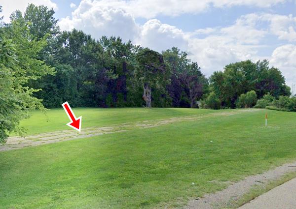
At the park the original 1926 hiwhgay turned west, along E. Andrew Rd. until it reached Old Tipton School Rd. where it turned south with a 90° turn along the old stagecoach route from Springfield to Peoria then it ran through what is now Carpenter Park and across the Sangamon River into Springfield. Where there is another part of the original roadway. But before heading there, take a short tour of Sherman.
Hide-A-Way Tavern
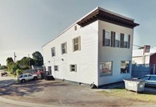
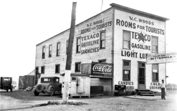
Take a left along E Andrew, as you cross the railroad, ahead, to your right, at 134 N First St. on its SE corner with E Andrew you will spot a two story narrow box-shaped building. This was at one time the Hide-a-way tavern, run by Vern C. Woods and his wife Nora Wertz. It was the place where the locals danced. R. Fishback ran it after 1938. It offeredr rooms for toirists, sold Texaco gasoline, sandwiches. Below is a 1930s photograph of the property that you can compare to its current appearance.
Double H Bar
Across the street, at 121 North First Street is the Double H bar. Built in 1946 from homemade concrete blocks poured here in Sherman. It has p>been serving drinks to US 66 travelers since then (the days of Rittenhouse's book).
Its first owner Richie Jerome named it Richie and Mary's after himself and his wife.
Lois Howard Hewitt (1928-2008) founded the Double H Bar, and she was also the manager of the Ann Rutledge Restaurant.
Retrace your steps and return to the four-lane alignment; turn left heading south towards Springfield. The original 1926-36 alignment ran west along E Andrews (red line in our custom map). Part of the old alignment along the western side of Sherman Village Park has been eliminated, but at the south side of the park, at cabin smoke trail, it resurfaces.
Withrow truck line & garage, Sherman, Il. Source
Withrow Garage (gone)
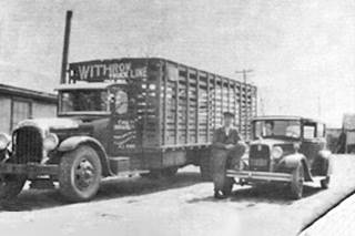
Roughly 300 feet south of E Andrew, to your left in what is now an empty field, once stood the garage and service station owned by Matthew E. Withrow; the Sherman Garage that sold Red Crown gas. Withrow also owned a "truck line." Rittenhouse mentioned this garage in 1946, and it can be seen in this aerial photo taken in 1946.
Ann Rutledge Motel (gone)
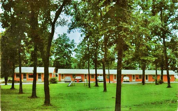
Drive south to Cabin Smoke Trail. Here, on the northwestern side of the crossroads was this motel, its postcard pictured below proclaimed "ANN RUTLEDGE MOTEL AND DINING ROOM Swimming Pool 3 Miles North of Springfield, III. on U. S. 66 11 Modern Units - Carpeted - Fully Air Conditioned. TV's - Thermostatic Controlled Heat - Tub and Shower Combinations - Spacious Playground - 24 Hour Telephone Service - Open Year 'Round."
Ann Mayes Rutledge (1813 – 1835) is said to have been the first love of Abraham Lincoln. He was heartbroken when she died of typhoid fever; he wrote about her: "I did honestly and truly love the girl and think often—often of her now..."
See this map marking its location; you can also see it in this 1964 aerial photo on the upper left side of the crossroads.
Historic Route 66 by Carpenter Park (1922-1936)
Listed in the National Register of Historic Places
Turn right along Cabin Smoke Trail. To your left, on the south side of the road is Carpenter Park. And just 600 ft (200 m) west of the four-lane alignment you will spot the original roadbed of Route 66 (1926-36). Below is a view looking north along the old alignment.
On the south side of Cabin Smoke Trail is the longer intact segment, that begins here and ends at the abutment of the Old Iron Bridge on the Sangamon River. It is barely 1⁄4 mile long.
Route 66 by Carpenter Park (1922-1936) in Sherman, Illinois
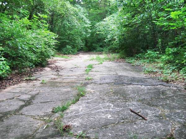
No cars have driven along it since 1936. It is a two-lane road that is 16-feet wide. Built four years before the creation of Route 66 it was included in its alignment as it was paved.
It is a cement and gravel roadway with 4-foot gravel shoulders and four inch curbs.
It was replaced by a wider and straighter alignment to the east in 1936. The bridge across Sangamon River has been removed only its concrete abutments survive.
Read all about the alignments of Route 66 in Sherman in the following report:
The park is named after William Carpenter who built a saw and grist mill on the Sangamon river close to the modern US66 bridge. It was built by William and his son-in-law Adolphus Wood in 1845. It had a rock dam to power the water wheel. It closed in 1870 and fell apart.
Continue your Road Trip
This marks the endpoint of your journey through Sherman and its Rte 66 sights. Return to the freeway and cross the 1936 Sangamon River bridge to continue your Route 66 road trip by heading west into the next town, the state capital city, Springfield Illinois.

Sponsored Content
>> Book your Hotel in Chicago

Credits
Banner image: Hackberry General Store, Hackberry, Arizona by Perla Eichenblat
Jack DeVere Rittenhouse, (1946). A Guide Book to Highway 66.


