Driving the original course of Route 66
Index to this page
Chatham, Illinois: all about it
Trivia, Facts and Useful Information
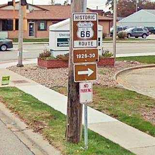
Historic US 66 signs in Chatham depot.
Elevation: 599 ft (183 m). Population 13.231 (2010). Time zone: Central (CST): UTC minus 6 hours. Summer (DST) CDT (UTC-5).
Chatham is a village located in Sangamon county. Southwest of Springfield.
The History of Chatham
People have been living in what nowadays is the state of Illinois for over 11,000 years, since the last Ice Age ended. Later, when the first European explorers (French, coming from Canada) reached the area, they encountered the Illinoisian Indians. This took place in the 1600s.
The territory was ceded by France to England after the Seven Year War in 1763, and after the American Independence it became a Territory of the U.S.A, it was admitted into the union as the state of Illinois in 1818.
The first settlers reached what is now Chatham (pronounced "Chat-uhm") in 1816 it became a corn farming area. Shortly after (1821), Sangamon County was established. It was named after the Sangamon River, which runs through it. The name Sangamon may be an Indian word of Pottawatomie origin (Sain-guee-mon = "where there is plenty to eat") or name given by the French explorers (St. Gamo, a French saint).
It was laid out in 1836 by Luther Ramson the post office opened in 1840 but was named "Lick Creek" it changed to Chatham in 1841. It incorporated as a village in 1874.
The name Chatham
It was named after the Chatham Presbyterian Church organized in 1835 by the Revs. Dewey Whitney and T. A. Spilman. It was named after the Chatham Presbyterian Church in Pittsylvania, Virginia.
Chatham is a place-name surname for residents of Cheetham, Lancashire, England meaning in Gaelic "Ced" (forest) and Anglosaxon "Ham" (village): Village by the forest.
The railroad reached Chatham in 1852 (read more below: Chatham Depot).
Route 66 was aligned through the cityin 1926 following State Highway SBI 4. However it was short lived because in 1930 it made straighter and shorter and realigned three miles further east through Glenarm, bypassing Chatham.

Chatham, its Hotels and Motels
Lodging & accommodation in Chatham; sponsored content. Find a room in neighboring Springfield, just a few miles to the north:
> > Book your hotel nearby, in Springfield
More Accommodation near Chatham on Route 66
Below you will find a list of some of the towns along Route 66 east and west of this town; click on any of the links to find your accommodation in these towns (shown from east to west):
Along Route 66 in IL
- Hotels in Illinois
- Route 66 Starting point ▸ Chicago
- Lockport
- Willowbrook
- Bolingbrook
- Plainfield
- Romeoville
- Joliet
- Wilmington
- Dwight
- Pontiac
- Chenoa
- Normal
- Bloomington
- Atlanta
- Lincoln
- Springfield
- Raymond
- Litchfield
- Staunton
- Williamson
- Hamel
- Edwardsville
- Collinsville
- Troy
- Glen Carbon
- Pontoon Beach
- Granite City
- East St. Louis
West in Missouri
- Hotels in Missouri
- Florissant MO
- Bridgeton MO
- St. Louis MO
- Kirkwood MO
>> Check out the RV campgrounds in Springfield, Lichtfield, and also in Raymond
Chatham's weather
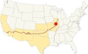
Location of Chatham on U.S. Hwy. 66, Illinois
Chatham has a "humid continental" climate with wet and hot summers (which are quite long) and short but very cold winters -with plenty of snow and bitter wind.
The average temperature is 52.4 °F (11.3°C). The average winter temperatures (Jan) are: low 21°F (-6°C) and high 35°F (1.7°C). The summer averages (Jul) are: high 86°F (30°C), and low: 68°F (20°C).
In Chatham snow may fall for over four months with an average 22 inches (56 cm) of snowfall yearly. Rainfall average is around 35.2 in. (893 mm) per year.
Tornado risk
The countryside around Chatham is hit by some 7 tornados per year. Tornado Risk: learn more about the Tornado Risk on US 66.
Map of Route 66 through Chatham in Illinois

1929 roadmap south of Springfield. Source
Click on Map to Enlarge
This highway was paved between 1923 and 1926, and that same year, 1926 when U.S. Highway 66 was created, it was aligned along the new IL-4 roadbed. Initally Route 66 and State Bond Issue (SBI) 4 overlapped until the signs of the old state higway were finally replaced by the U.S. 66 shields in 1927.
1926-1930 US 66
From the start, the Illinois Division of Highways headed by Thomas Sheets had sought a straighter highway south of Springfield, and Sheets wrote an article in the state's 1924-24 Blue Book proposing "Route No. 126.—Beginning at Springfield and extending in a southerly direction to Litchfield, affording Springfield, Divernon, Waggoner, Litchfield and the intervening communities reasonable connections with each other." As soon as Route 66 was aligned along IL-4, plans were drawn to realign it along IL-126. The 1929 roadmap (click image for full sized map) shows that work began in 1928 and by 1929 The old IL-4 state highway was marked also as "T 66" ("temporary 66") while the construction work along former state highway IL-126 continued and part of the new US 66 alignment had already been built and paved along it: in the south to Litchfield and Raymond, and in the north to Glenarm.
But let's focus on the original Route 66, and follow its alignment soutwards from downtown Springfield.
The 1926 US66 alignment out of Springfield towards Chatham
Leaving Springfield
The first alignment is marked with an with an Orange line in our customized zoomable map of Route 66 in Springfield (also in this map with directions).
As you can see it has many sharp 90° turns as it zig-zags its way across Southwestern Springfield.
Old Chatam Road Bridge (Lick Creek)
Two alignments at Woodside Rd.
When Route 66 reached Woodside Road, it curved towards the SW to cross Lick Creek and head towards Chatham (below is one of these two alignments, it is the original highway forking from Woodside Rd.)
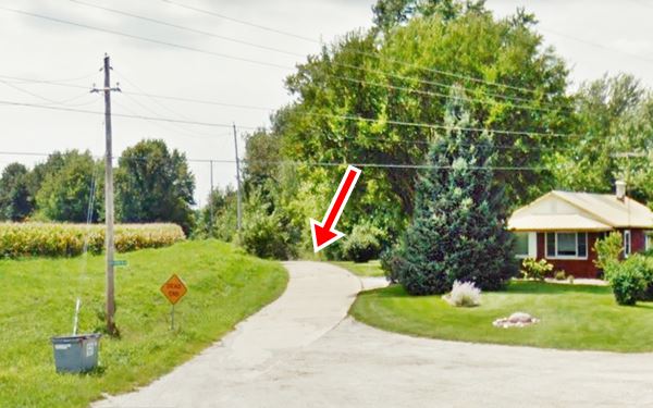
The second alignment is further east, and more or less parallel to the original one.This newer roadbed was cut off from Woodside Rd. when the new IL-4 highway was built in 1975 along Veteran's Parkway. There is a surviving segment that can be driven (see map) and a the gap of the missing segment is marked with a black line in our custom map. Below are two USGS maps showing this spot:

1924 USGS map of Lick Creek , Chatham, Il

1961 USGS map of Lick Creek , Chatham, Il
Lick Creek Bridge
Built in 1919 with a brick deck, it is also known as the Old Chatham Road Bridge or Schuster Bridge:
Route 66 at Lick Creek Bridge in Chatham, Illinois
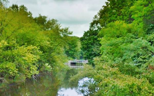
On the south side of the river, the road was abandoned. It headed to what it now Veteran's Pkwy with a NE to SW course.
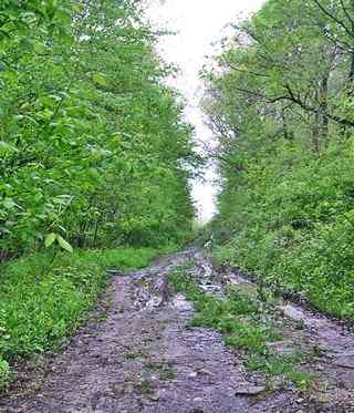
Abandoned US 66 south of Lick Creek bridge, Chatham, Il. Source
Across Chatham
To continue your trip return to Woodside turn left and head west. Turn left again to head south along Veterans Parkway into Chatham (3 mi)
The highway went along Main Street to cross Chatham turned right along West Walnut to turn again, left, southwards along Church St.
The curved section of modern IL-4 between W. Spruce and S. Church wasn't built until the late 1930s.
The Route 66 alignment in Chatham
Visit our pages with old maps and plenty of information about US 66's alignments.
- Route 66 Hamel IL to St. Louis MO (Next)
- Springfield to Staunton IL (1926-30 US66 near Chatham)
- Springfield to Hamel IL (1930-77 US66 to the east of Chatham)
- Route 66 Pontiac to Springfield IL (Previous)
Original 1926-1930 alignment Chatham to Red Brick Road
The 4.6 mile trip from Chatham to the Historic Brick Road just north of Auburn is shown in this Map with Directions.
> Read more about Brick paved sections of Route 66.
Chatham: classic US 66 Sights
Landmarks and Attractions
Drive south from Springfield into Chatham following the directions given above (Map of US 66 in Chatham). On the north side of town is the Old bridge described further up.
It is said that the bridge is the habitat of an endangered snake, the Kirtland's Snake:
Kirtland's Snake
This area is a natural preserve, and is also the habitat of an endangered snake, the Kirtland's Snake (Clonophis kirtlandii), an endangered North American species of nonvenomous snake with a geographic range that spans Illinois, Indiana, Ohio, southern Michigan, western Pennsylvania and north Kentucky. It likes to live close to water.
Retrace your steps to Woodside, head west and turn south (left) along Veterans Pkwy into Chatham. Along the highway you will spot a mansion from the mid 1800s:
Caldwell Farmstead
Listed in the National Register of Historic Places
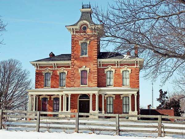
Ahead, to your right, 1.2 miles south of the turn on Woodside Rd you will see a historic mansion. This magnificent building is almost 150 years old. It is also known as the Caldwell Mansion, Thomas House, and Payne Thomas House.
The Caldwell Mansion was built in 1876 in a style popular at that time: Italianate Villa. It is a two-story red-brick building with a three story tower topped with a cupola. The building has thin windows, steep pitched roof and a veranda-style front porch. Roman columns made in white stone support the porch.
Benjamin F. Caldwell (1848-1924) had it built as his home -he lived here with his mother. It had gas lighting, steam heating and running water. Mr. Caldwell was a Springfield banker and politician.
Site of former Phillips 66 Gull wing station
Continue your journey southwards into Chatham. Almost all of the gas stations along IL-4 dating back to the 1930s to 90s have gone. An example is a Gull Wing Phillips 66 service station that stood on the NW corner of West Washington and Main (shown in this Aerial photo taken in 1981. Now a fast food restaurant stands on the spot (Learn more about Phillips 66 Gull Wing stations on Route 66).
Downtown Chatham has several buildings from the early 1900s:
Old Store (A.J's Corner)
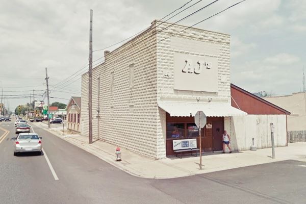
To your left, on the NE corner of E Mulberry St. and Old Route 66. This building appears in the Sanborn Fire insurance map of Chatham published in 1917. It shows it was a confectionery, its blue coloring in the map tells us it was built in stone. Over the years it served different purposes: Whitney's Ice Cream Parlor before the 1920s, a restaurant (CW's) during the 1930s. It was a tavern before becoming the current pub (A. J.'s corner).
Order of the Odd Fellows (IOOF) and Caldwell Bank building
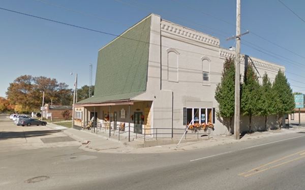
To your right, on the NW corner of Route 66 and W Mulberry St. is a very ugly building: "Caldwell Building". Its original brick facade has been modified with a faux shingle vertical roof covering the top story facing Mulberry.
It was built in 1868 to serve as the lodge (Hall) of the local chapter of the Independent Order of Odd Fellows (IOOF) (Odd Fellows for short) is a secret charity society without any political or sectarian orientation. It was founded by Thomas Wildey in Baltimore, USA in 1819 (check their website).
It also housed the Bank of Chatham until Ben Caldwell (owner of the Farmstead) opened his Caldwell State Bank on the first floor in 1896. It also apperars (in red = bricks) in the Sanborn map of 1917.
The post office, the local newspaper, and other businesses had offices here. Caldwell's bank folded during the Depression in 1931.
On the same block, just west of the bank building is an old garage that surely served those driving along Route 66 in the 1920s.
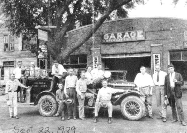
Cary's Garage
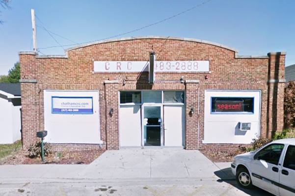
The brick building was built in 1919 by Ralph Butler, who owned the shop. Everett Cary (1898-1969) worked with the new owner, Charles Stevens. Carey bought the garge in 1923 and eventually added a Chevrolet dealership to his business. In 1955 he sold it to John Schroeder. The garage had gas pumps across the street.
Now it is the Children's Recreation Center of Chatham. Below is a set of "Then and Now" pictures, the one from 1929 is contemporary of Route 66 in Chatham.
Turn back head easst along E. Mulberry St., and when you reach State St. and the railroad tracks, turn right. To your left is the old depot and Museum:
Chatham Railroad Museum
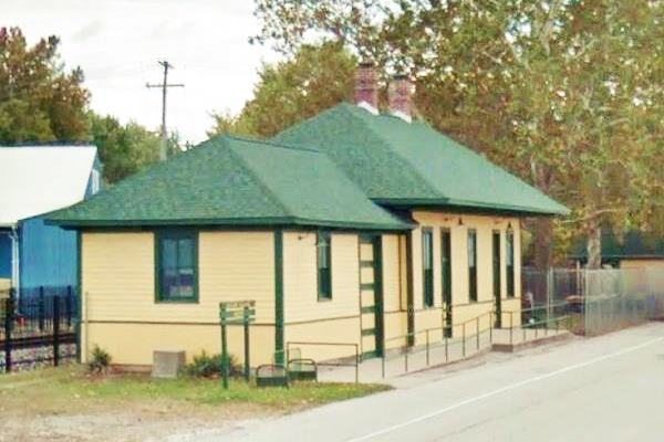
100 N State St, Chatham. The original depot burned down in 1902 and was immediately replaced by the current one. It is now the local museum with displays of the region's railroad history.
The Alton and Sangamon Railroad reached Chatham in 1852, and changed names many times (Chicago and Mississippi, Chicago, Alton and Mississippi, Chicago and Alton, Alton Railroad) before becoming the Gulf, Mobile and Ohio RR.
The station closed in 1972 and is now owned by the Village of Chatham, it was restored in 1991 becoming a museum.
Chatham Railroad Museum (1902) in Chatham, Illinois
Below is a vintage picture of the old depot:

Vintage picture Chatham depot. Source

Aerial view of the gas station (1981). Source
Click image for full size picture
Icebox Gas Station
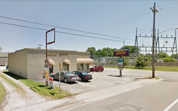
This is a 1940s-50s icebox style gas station: block-shaped building with a corner office facing both Route 66 and West Chestnut St. and two service bays facing Route 66.
The building is still standing. Windows have replaced the garage doors. No signs remain of the pumps. Click on the 1981 thumbnail of an aerial photo (above) to enlarge it. Below is the current view, it has been repurposed as a store.
Corvair Museum
"Modern" attraction
The Corvair Museum is located on the original 1935-77 Route 66 between Springfield and Glenarm (2.2 miles north of Glenarm) and 4.5 miles east of Chatham at 10041 Palm Rd., near the Double J RV Campground. It has a lage collection of Chevrolet Corvair models, from regular ones to race cars. More information at their www.corvair.org. This is a map with directions from Chatham.
Continue your Road Trip along Route 66:
This part of your Route 66 Road Trip along the 1926-30 Route 66 in Chatham ends here, head south along the highway to visit Auburn.

Sponsored Content
>> Book your Hotel in Chicago

Credits
Banner image: Hackberry General Store, Hackberry, Arizona by Perla Eichenblat
Caldwell Mansion NPS Historic place registration form.
Jack DeVere Rittenhouse, (1946). A Guide Book to Highway 66

