Route 66 Road Trip in Nilwood:
Index to this page
All about Nilwood
Trivia, Facts and Useful Information
Elevation: 668 ft (204 m). Population 188 (2020).
Time zone: Central (CST): UTC minus 6 hours. Summer (DST) CDT (UTC-5).
Nilwood is located in Macoupin county IL, south of Springfield on the 1926-30 course of Route 66
The History of Nilwood
The first inhabitants of what is now Illinois, arrived when the ice sheets retreated some 11,000 years ago, at the end of the last Ice Age.
These Paleoindians were the ancestors of the modern Kickapoo, Illinois and Miami natives that were the historic natives encountered by the first European explorers in the mid 1600s.
France claimed the region as part of "New France" (now Canada) but lost it to Britain during the Seven Year War (1763). The independence of America (1776) saw the land change hands again; it became a territory of the U.S. when the American government purchased Louisiana from France in 1803.
The first settlers arrived in the mid 1810s and early 1820s. Illinois gained statehood in 1818.
John Woods was the first pioneer in this area; he arrived from Virginia in 1817. Macoupin County was established in 1829 and was named after Macoupin Creek.
That same year, John A. Harris became the first settler in Nilwood Township, in "Harris Point". Street opened a general merchandise store in Nilwood in 1831. Farmers grew corn as their main crop and Pitman built a gristmill here in 1838.
The Chicago and Altonr Railroad reached the area in 1852 and the village was platted by Samuel Mayo and Philander Bayley who owned the land, and the townsite was surveyed by F. H. Chapman in 1855. The post office opened the following year and the village incorporated in 1867.
The name Nilwood
The name is strange and its origin does not appear in the County histories published in the 1870s- Apparently it came from the engine drivers of the steam locomotives. Wood was used as fuel for the engine's boilers and as there were no trees in Nilwood they named it "Nil" "Wood" (no wood). Later coal replaced wood as the locomotives' fuel.
In 1926 Route 66 was aligned through Nilwood, using the paved alignment of state highway #4. In 1930 it was made shorter with a new alignment further east (present Histroic Route 66 from Springfield to Staunton through Litchfield).

Hotels and Motels close to Nilwood
Lodging & accommodation in Nilwood; sponsored content. Find a room in neighboring Springfield, just a few miles to the north:
> > Book your hotel nearby, in Staunton or Springfield
More Accommodation near Nilwood on Route 66
Below you will find a list of some of the towns along Route 66 east and west of this town; click on any of the links to find your accommodation in these towns (shown from east to west):
Along Route 66 in IL
- Hotels in Illinois
- Route 66 Starting point ▸ Chicago
- Lockport
- Willowbrook
- Bolingbrook
- Plainfield
- Romeoville
- Joliet
- Wilmington
- Dwight
- Pontiac
- Chenoa
- Normal
- Bloomington
- Atlanta
- Lincoln
- Springfield
- Raymond
- Litchfield
- Staunton
- Williamson
- Hamel
- Edwardsville
- Collinsville
- Troy
- Glen Carbon
- Pontoon Beach
- Granite City
- East St. Louis
West in Missouri
- Hotels in Missouri
- Florissant MO
- Bridgeton MO
- St. Louis MO
- Kirkwood MO
>> Check out the RV campgrounds in Springfield and Litchfield.
Nilwood's weather
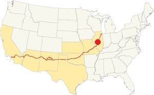
Location of Nilwood on U.S. Hwy. 66, Illinois
Nilwood has a "humid continental" climate with wet and hot summers (which are quite long) and short but very cold winters -with plenty of snow and bitter wind.
The average temperature is 52.4 °F (11.3°C). The average winter temperatures (Jan) are: low 21°F (-6°C) and high 35°F (1.7°C). The summer averages (Jul) are: high 86°F (30°C), and low: 68°F (20°C).
In Nilwood snow may fall for over four months with an average 22 inches (56 cm) of snowfall yearly. Rainfall averages some 35.2 in. (893 mm) yearly.
Tornado risk
The countryside near Nilwood is hit by some 7 tornados per year. Tornado Risk: learn more about the Tornado Risk on US 66.
Map of the 1926-30 Route 66 through Nilwood
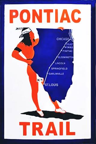
The Pontiac Trail symbol shield. A. Whittall
Historic background: Pontiac Trail
The predecessor of Route 66 was the "Pontiac Trail". The use of automobiles grew in during the early 1900s and this led to a public demand for better roads, suitable for cars.
Dirt trails used by horse-drawn carts with deep ruts, which became muddy traps during the rainy periods were unsuitable for cars.
A private association was formed in 1915 to promote the Pontiac Trail which would be built, and become a "solid surface road" linking Chicago with St. Louis. It was named for the famous chief of the Ottawa Indians.
The President of the State Highway Commission mentioned it in 1915 as part of the new legislation supporting state aid for highways (1)
The B.F. Goodrich tire company marked its milage posts with its custom shield sign (see image).
In 1918 the state government floated bond, creating the State Bond Issue (SBI) Route 4, which roughly coincided with the old Pontiac Trail.
This state Route 4 was completely paved by 1926 and US 66 -created that same year- ran along IL-4 alignment.
1926-1930 US 66
This first alignment of Route 66 south of Springfield had a winding course following the former county lanes and lot demarcation trails. It had many sharp 90° curves. This made it unsafe and also longer. The highway ran between Staunton and Springfield through Nilwood.
The pink line in our custom map shows how it zig-zagged its way across the farmland crossing the railroad three times! Also see this map with directions.
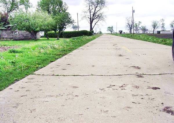
Old Historic Route 66 running through corn fields between Girard and Nilwood
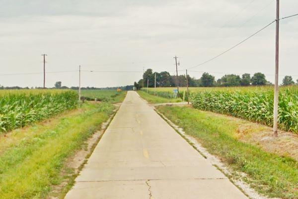
It has survived the wear and tear for 100 years and although it has cracks, it still has its original concrete paving plus the concrete box culverts.
The Route 66 alignment in Nilwood
Visit our pages with old maps and plenty of information about US 66's alignments.
- Route 66 Hamel IL to St. Louis MO (Next)
- Springfield to Staunton IL (1926-30 US66 near Nilwood)
- Springfield to Hamel IL (1930-77 US66 to the east of Nilwood)
- Route 66 Pontiac to Springfield IL (Previous)

Nilwood: classic US 66 Sights
Landmarks and Attractions
Drive into Nilwood, coming from Girard along the Historic Route 66 segment listed in the National Register of Historic Places.
Route 66, Girard to Nilwood (1919-1931)
Listed in the National Register of Historic Places
This was a period of transition from cart, horse and mule to truck and cars. The old dirt track was replaced by a state of the art highway (by early 1920s standards): it was a concrete highway that had two eight-foot wide lanes and gravel shoulders 7 feet wide. The Portland concrete slab was 6 inches thick.
The original Illinois Route 4 in this area was paved between 1920 and 1922, it followed the former county lanes and lot demarcation trails and therefore had many sharp 90° curves.
This made it unsafe and also longer.
The pink line in our custom map shows how it zig-zagged its way across the farmland crossing the railroad three times! Also see this map with directions.
It has some sharp turns and runs along a narrow concrete roadbed. Just before it reaches Nilwood is the railroad underpass:
Old Historic Route 66 running under a railroad north of Nilwood
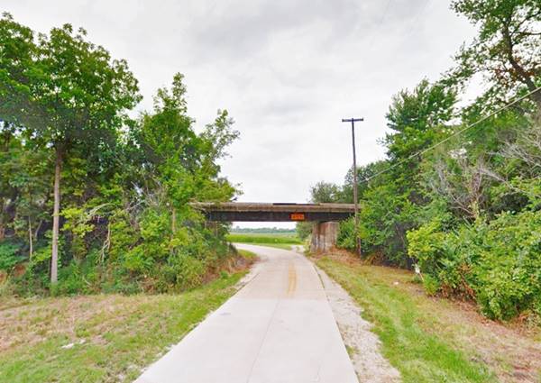
Notice the curve after the underpass: a sharp 90° changes the course from east-west to north-south. There are two more sharp turns before the highway reaches Nilwood.
Nilwood Elementary School (Gone)
It finally runs into the town along Morean St. here, on the NW corner of Morean and Pine St. once stood the local school. It was built in 1927, the year after Route 66 was created. As the population dwindled there were less children so it closed in 1970, fell into disrepair and was razed in 2013. Below is a sequence showing its decay:
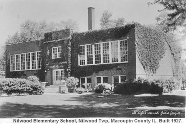
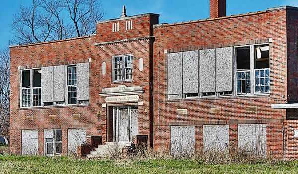
The school in 2007 before it was torn down:
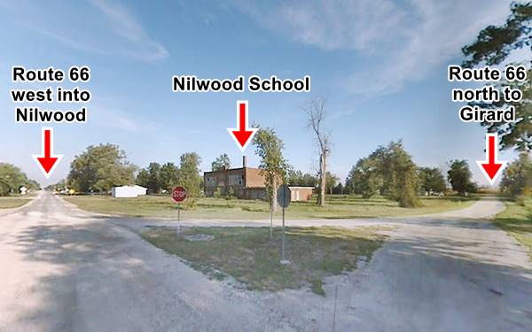
The highway crosses the "downtown", nothing remains of the old Route 66, no gas stations or motels or restaurants. Some red brick buildings face the street, with empty lots between them. The old Post Office in a former bank building stands next to the Village Hall, both on the south side of the street.
On the west side of town the 1926-30 alignment meets modern Stat Highway 4 coming from Girard. Here is a motorcycle club.
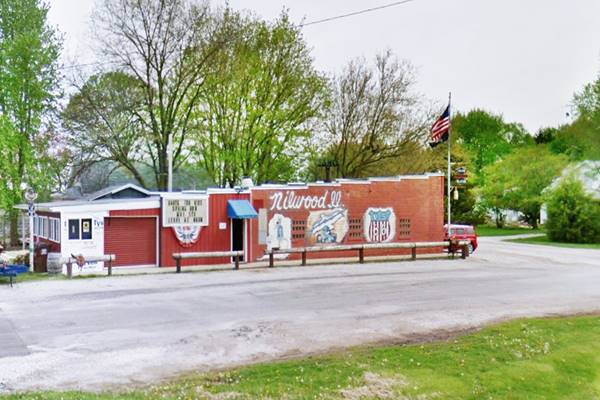
Iron Sleds Motorcycle Club
To your right, at 12 Morean St, on the NE side of the highway junction. It has a wacky mural along the wall facing IL-4.
Leaving Nilwood
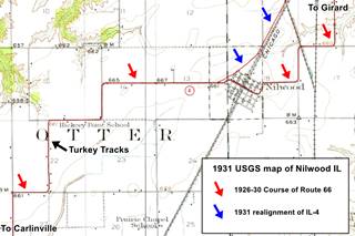
Now turn left and drive west along IL-4, for a while it follows the original Route 66 alignment. It was straightened out in the 1930s to make it shorter and safer: compare the 1926 course (2.8 miles and 5 sharp curves) with the mid 1930s alignment (2.2 miles and no sharp curves).
The map shows (blue arrows) the road north of Nilwood, towards Girard in 1931 and with red arrows, the "stair-step dogleg" towards Carlinville. Our custom map marks the 1926 alignment west of Nilwood all the way to Carlinville with a green line.
Turkey Tracks

Turkey Tracks sign, Nilwood, Il. Source
Wacky Route 66 attractions
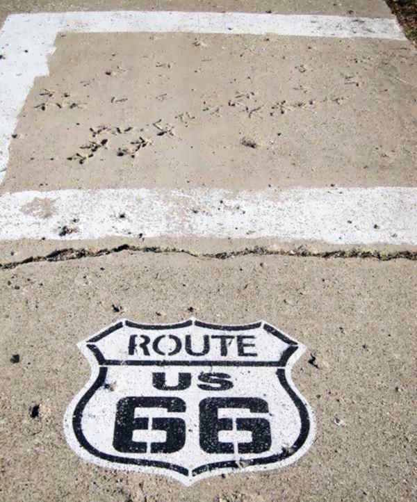
At Donaldson Rd. (Old Route 66) Nilwood. This is a map marking where the tracks are located.
You will see the tracks on the left (eastern side of the road), there is a sign marking the spot (image) and a white square on the road surface to mark the spot. You can't miss it!
Below is a photo of the "turkey tracks", imprinted in the wet cement by a turkey (or group of turkeys) that walked across the roadway when the highway was built back in the early 1920s.
When were the turkey trakcks made?
These tracks predate Route 66 (created in 1926) because they were made when Illinois Route 4 was paved in concrete around 1919 to 1921 so These track prints are over one hundred years old.
We know that it was already paved by 1921 because a contemporary article tells us that "To Carlinville the pavement is all laid with the exception of a short stretch at Thayer... from Carlinville to St. Louis the concrete is all laid..." (3).
Wild turkeys or domestic ones?
The only wild turkey found in Illinois is the Eastern Wild Turkey Meleagris gallopavo silvestris, it is one of the six subspecies of turkey found in the US. But they were overhunted and wiped out in Illinois by 1910, and were reintroduced between 1959 and 1967 from Missouri.
This means that there were no wild turkeys in Nilwood Illinois in the 1920s because they had been exterminated a decade earlier.
The culprit then must have been domestic turkeys from a nearby farm. Below are two images of the tracks:
A View of the Turkey tracks on US 66 concrete in Nilwood, Illinois
When concrete is poured, the mixture of water, sand, gravel and cement form a paste that stays wet for a relatively short period of time. Ambient temperature, humidity, and the composition of the mixture define how long it will remain wet. Maybe a print could be preserved if it was made within the first two to four hours. A bird would need wetter cement to leave a print. A heavier animal could do so later as the concrete would yield under its weight.
Barn with 13-star flag painted on it
Americana: American culture along Route 66
Continue along the old Route 66 and after 2.6 miles, on the north side of its junction with 24500N Rd. (map with directions from the Turkey tracks).
On the west side of the highway (right) you can see this painted barn with the "Betsy Ross" flag painted on its eastern face, it is pictured below:
The Betsy Ross Flag
The Betsy Ross flag was one of the first U.S. flags designed. It is attributed to Betsy Ross based on a story (most likely apocriphal) pubished in 1870 by her grandson William Canby.
According to Canby, Besty modified the design given to her by a committee (which included George Washington) and used five-pointed stars instead of six-pointed ones.
Barn with 13-star flag painted on it in Nilwood, Illinois
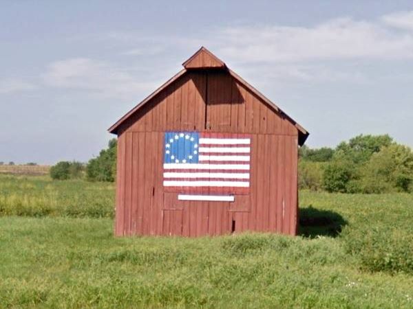
The 13-star flag painting on the barn is a great example of Americana: a barn in a midwestern field with the first American Flag: it has the 13 stripes that the present flag has (one for each of the original colonies) and also 13 stars (for the same reason).
Continue your Road Trip along Route 66:
This leg of your Route 66 Road Trip along the 1926-30 alignment through Nilwood ends here. Drive south towards Carlinville to continue your adventure.

Sponsored Content
>> Book your Hotel in Chicago

Credits
Banner image: Hackberry General Store, Hackberry, Arizona by Perla Eichenblat
Nilwood History


