Route 66 Road Trip in Carlinville:
Index to this page
- About Carlinville
- Weather
- Hotels in Carlinville
- Map of US 66 in Carlinville
- What to see and do in Carlinville
Carlinville, Illinois: all about it
Trivia, Facts and Useful Information
Elevation: 619 ft (189 m) . Population 5,479 (2024).
Time zone: Central (CST): UTC minus 6 hours. Summer (DST) CDT (UTC-5).
The city of Carlinville is Macoupin County's seat and is located in south-central Illinois on the 1926 to 1930 course of U.S. highway 66.
The History of Carlinville

Thomas Carlin
People have been living in what nowadays is the state of Illinois for over 11,000 years, since the last Ice Age ended. Later, when the first European explorers (French, coming from Canada) reached the area, they encountered the Illinoisian Indians. This took place in the 1600s.
The territory was ceded by France to England after the Seven Year War in 1763, and after the American Independence it became a Territory of the U.S.A, it was admitted into the union as the state of Illinois in 1818.
O.W. Hall settled here in 1817. Macoupin County was established in 1829 and was named after Macoupin Creek (the word is a Miami-Illinois term for the American lotus Nelumbo lutea).
The name Carlinville
Named for Thomas Carlin, (1789-1852), the 7th Governor of Illinois (1838-42). When he was a member of the state legislature he pushed for the creation of Macoupin County.
Carlin is common in Ireland and Scotland, the English form of the Gaelic Ó Cairealláin, (the descendant of Caireallan).
The town of Carlinville was founded at the same time (1828). Blackburn College, affiliated with the Presbyterian Church (U.S.A.), was established in 1837.
Route 66 was aligned through the city in 1926 and remained so until 1930 when it was shortened and realigned 12 miles to the east through Litchfield, bypassing Carlinville.

Hotels and Motels in Carlinville
Lodging & accommodation in Carlinville; sponsored content. Find a room in neighboring Springfield, just a few miles to the north:
> > Book your hotel nearby, in Springfield
More Accommodation near Carlinville on Route 66
Below you will find a list of some of the towns along Route 66 east and west of this town; click on any of the links to find your accommodation in these towns (shown from east to west):
Along Route 66 in IL
- Hotels in Illinois
- Route 66 Starting point ▸ Chicago
- Lockport
- Willowbrook
- Bolingbrook
- Plainfield
- Romeoville
- Joliet
- Wilmington
- Dwight
- Pontiac
- Chenoa
- Normal
- Bloomington
- Atlanta
- Lincoln
- Springfield
- Raymond
- Litchfield
- Staunton
- Williamson
- Hamel
- Edwardsville
- Collinsville
- Troy
- Glen Carbon
- Pontoon Beach
- Granite City
- East St. Louis
West in Missouri
- Hotels in Missouri
- Florissant MO
- Bridgeton MO
- St. Louis MO
- Kirkwood MO
>> Check out the RV campgrounds in Springfield and Litchfield.
The weather in Carlinville
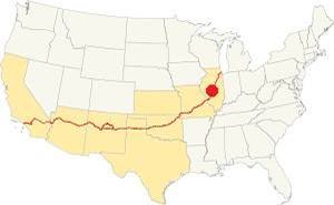
Location of Carlinville on U.S. Hwy. 66, Illinois
Carlinville has a "humid continental" climate with wet and hot summers (which are quite long) and short but very cold winters -with plenty of snow and bitter wind.
The average temperature is 52.4 °F (11.3°C). The average winter temperatures (Jan) are: low 21°F (-6°C) and high 35°F (1.7°C). The summer averages (Jul) are: high 86°F (30°C), and low: 68°F (20°C).
In Carlinville snow may fall for over four months with an average 22 inches (56 cm) of snowfall yearly. Rainfall averages some 35.2 in. (893 mm) yearly.
Tornado risk
The countryside near Carlinville is hit by some 7 tornados per year. Tornado Risk: learn more about the Tornado Risk on US 66.
Map of the 1926-30 Route 66 through Carlinville
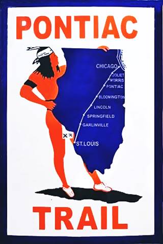
The Pontiac Trail symbol shield. A. Whittall
Historic background: Pontiac Trail
A private association was formed in 1915 to promote better roads, and one of them was the "Pontiac Trail", a projected "solid surface road" that would link St. Louis with Chicago.
The association named it after the well known Ottawa Indian chief. They secured the support of the B.F. Goodrich tire company to mark its mile posts and they even designed its own shield (image).
The state of Illinois' government took over the responsibility for better highways and issued a bond in 1918 that created the State Bond Issue (SBI) Highway No. 4 which was more or less aligned along the Pontiac Trail.
This highway was paved between 1923 and 1926, and that same year, 1926 when U.S. Highway 66 was created, it was aligned along the new IL-4 roadbed.
1926-1930 US 66
This first alignment of Route 66 south of Springfield had a winding course following the former county lanes and lot demarcation trails. It had many sharp 90° curves. This made it unsafe and also long.
Route 66 after 1930
Seeking a straighter alignment the Illinois Division of Highways led by Thomas Sheets moved Route 66 eastwards through Mt. Olive and Litchfield and Divernon along Stae Highway 126.
The 1930's alignment branched off from the older one in Staunton in the south, and reunited with it further north, in Springfield. It bypassed Carlinville.
It is a 12-mile drive between both towns, see this map from Nilwood to Carlinville with the 1926 US 66 course.
The original highway had a sharp turn at Harvest Rd. where Gore School once stood. It was bypassd and smoothed after 1956 because it still appeared in an aerial photo taken in 1956.
Ahead on the north side of Carlinville it took a right along Shad Rd. and a left along N. Broad St.
This was replaced by the current alignment in 1931. The underpass on the later alignment avoided the grade crossing.
The highway went south along N Broad St. and reached the town's main square, where it crossed IL-108. The streets around the main public square are still paved with red bricks.
Route 66 left the square with a west-to-east course along E Main St., and turned south along S. Center St. Here there are some realignments and missing segments. This is a map with directions across Carlinville showing the driveable road. Our custom map shows the same alignment and missing sections with a red line.
Missing segment between E 1st St. and Jacobs Rd.
The higway ran further west, crossed the current alignment and then ran east of it, crossed Briar Creek and passed current Jacobs Rd before merging with the current alignment.
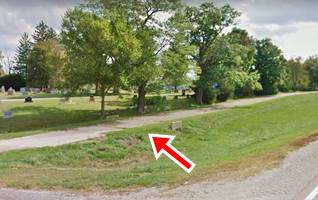
The modern alignment runs to the left of the old road shown in the photo below:
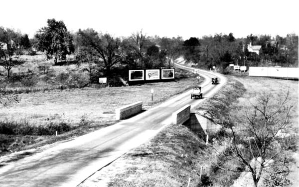
This alignment survived until recently, it can be seen in this aerial photo from 1956. Notice that Jacobs Rd. did not exist at that time.
See pin marker next to the red line in our custom map.
1920s Original Road Surface (Carlinville Cemetery)
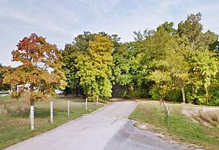
Continue south along old 66 - modern IL-4 and when you reach Country Club Ln. Carlinville Cemetery begins, to your left, on the eastsern side of the highway. The original highway roadbed curved to the east and ran along the edge of the cemetery. You can still see the narrow roadbed of this original road (pictured below).
See this 1956 aerial photo showing the highway running along the now dead-end in the local cemetery. The southern part of this segment is shown in this satellite view, and with a marker in our custom map (by the red line).
Macoupin Creek segment
After the cemetery, the later alignment runs with a NW-SE course, but the original highway curved east heading towards the now gone Macoupin Creek bridge (only the abutments remain), then it curved south and it meets the current IL-4 alignment (pictured). See marker by the red line in our map and also this aerial photo (1956).
Southwards Into Gillespie
Drive towards the next town along the highway: Gillespie. Head south from the Macoupin Creek segment, the highway curves to take a north-south alignment and at the curve is another abandoned segment.
See it in this 1956 aerial view, and in our custom map marked with a purple line it was widened to its current position in the 1960s.
The Route 66 alignment in Carlinville
Visit our pages with old maps and plenty of information about US 66's alignments.
- Route 66 Hamel IL to St. Louis MO (Next)
- Springfield to Staunton IL (1926-30 US66 near Carlinville)
- Springfield to Hamel IL (1930-77 US66 to the east of Carlinville)
- Route 66 Pontiac to Springfield IL (Previous)

Carlinville: classic US 66 Sights
Landmarks and Attractions
Reach Carlinville driving along Historic U.S. 66 from Nilwood; you will enter the city from the north turning righ along Shad Rd and then left along N. Broad St. On the north side of the tracks, just before the old grade crossing is a former garage:
Old 1920s garage
On the NW corner of N Broad and Blackburn St. to your right is an old red-brick building on a corner, with white decorations around the windows. It is currently a body-shop, but its appearance shows it was a garage.
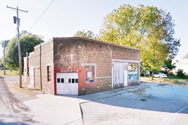
The grade crossing ahead was replaced with an underpass on the 1930s State Hwy 4 that was built after Route 66 had been moved east through Litchfield.
Before heading along Route 66 into downtown Carlinville, take a short detour -1.3 mile round trip- (map with directions) to visit some sights on the north side of town:
Carlinville Plaza Neon Signs
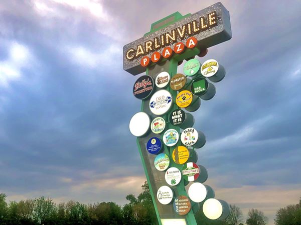
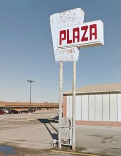
the original shopping mall opened here on March 2, 1977. Its neon sign is still standing in the parking lot. But the newer one is a real eye-catcher; it was designed by Springfield-based Ace Sign Co., using a vintage style and modern technology. It is a 40-foot-tall sign with 44 individual circles lit with LEDs.
From the mall, head west, then south to visit the Sears Catalog homes:
Sears Catalog homes
Turn left along Wilson St., and right on University St., then right along Rice St. From here westwards is the Sears Addition district. It runs from N. High to University St. -including transversal streets- along Rice St.
It is Largest collection of Sears Catalog homes in the whole world.
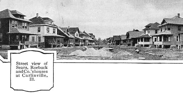
Sears, Roebuck & Co. began selling their mail order catalog homes in 1909, they came in many sizes and models, they were "kit homes" with all the parts and pieces cut to size. They were assembled on site.
The company sold over 70,000 homes between 1909 and 1940. There is another Sears kit house on Route 66, the Hogue House in Chelsea Oklahoma, built in 1912 and listed in the National Register of Historic Places (the first house of its kind in Oklahoma and east of the Mississippi River).
In Carlinville, they were built by the Standard Oil Company for the company's coal mine workers. in 1918 the oil company bought 192 kits and ended up building 156 homes in town, of which 152 are still standing.
They were built in a new district, known as "Standard Addition" on the northeastern side of Carlinville.
The picture above was published in the 1921 Sears Modern Homes catalog (check a Sears catalog from 1912).
Sears Catalog homes nowadays.
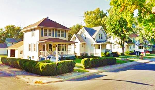
The Standard Addition Neighborhood Association (SANA) formed in 2014, and has plans to restore the area.
Return to Route 66 (N Broad St.) and turn left along it to drive into the downtown area of Carlinville.
Carlinville Mural
On the north facade of Advanced Eye Care, to your left at 615 N Broad S. It has the letters "CARLINSVILLE" decorated with Abe Lincoln, a Rotary Club shield and a Route 66 shield, plus some local buildings.

Carlinville Mural. Source. Click for street view
The Route 66 Wayside Exhibit
To your right, on the NW corner of Broad St. and W. Nicholas St.
The exhibit has two panels with plenty of information on Carlinville and its attractions.
Carlinville's Main Square
Red Brick Paving
As you enter the town's main public square, notice its Red Brick Paving. Paving with bricks was a common practice in the early 20th century because it was cheap, tough and didn't require special machinery as it could be hand-laid.
> Read more about Brick paved sections of Route 66.
Look to your left on the "East Side of the Square", there, on its northeastern corner is an hotel from the 1870s:
Loomis House (St. George Hotel)
At 118 East Side Square, Carlinville.
Thaddeus Loomis was wealthy a local land owner who in 1861 was elected as county judge. He worked from the courthouse built in 1830 but by 1865 Loomis considered that it was too small for his needs, so he commissioned a new one appointing Elijah E. Meyers as architect and threw into the project the new county jail.
Loomis was involved in the Macoupin County's "Million Dollar Courthouse" scandal back in 1869.
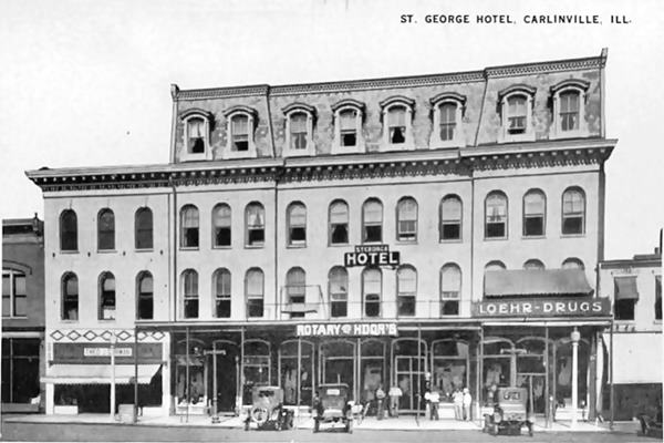
Loomis had this hotel designed for him by E. E. Meyers on the town's main square and called it "Loomis House"; it opened in 1870 as a hotel with 50 rooms and it was built in the same limestone that was used in the County Courthouse.
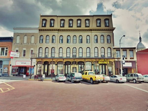
Later Loomis lost it as he foreclosed on the mortgage, and it became the "Saint George Hotel". Below is a "Then and Now" sequence of the building that saw the 1926-30 Route 66 traffic drive past it.
Loomis House (St. George Hotel) 1920 postcard in Carlinville, Illinois
Loomis House and brick paved street at Carlinville's main square
Drive round the square, when you reach the middle of the western side of the square, turn right along West Main Street (also paved in red bricks) to visit a Classic Movie Theater:
Marvel Theatre
On the second block, to your right, at 228 W. Main Street, on the NE corner of Main and N Plum St. It opened in 1920 and the Paul family owned it. After burning down in 1926 it reopened in 1928 and kept screening movies until 2014. It reopened recently.
Its current classic marquee is from the 1960s.
Old Cottage style Phillips 66
While you are on the western side of Carlinville, drive along W Main. Two blocks ahead, to your left on the SW corner of S. Locust and W Main is a Cottage Style Phillips 66 gas station. The building has a single service bay (pictured above). You can see it in this 1967 aerial photo on the lower right side, with its Phillips 66 sign and pumps.
Diane Drive-In
Keep driving west along Main (IL-108) for 1.8 miles (see this Map with Directions) and visit a classic Drive-In at 1950 N and Colt Rd, to your right.
The drive-in theater opened in 1952 and belonged to the same family that owned the Marvel Theatre. It could fit 300 cars and remained open until 1981. It is still there, slowly decaying.
Turn around and retrace your steps to the city's Main Square, turn right and drive around the square.
On its eastern side, where East Main heads out of town, is the original Ariston Cafe building:
Original Ariston Cafe
A Greek immigrant, Pete Adam opened his first cafe here in Carlinville on the Main square in 1924. Two years later Route 66 was aligned right beside his business. But he soon learned that it would be realigned through neighboring Litchfield, he followed it and relocated his cafe there in 1929.
The Ariston Cafe in Litchfield is Listed in the National Register of Historic Places and Inducted into the Route 66 Hall of Fame.
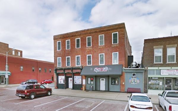
The name "Ariston" comes from Greek "αριστος" (aristos) and it means "the best". Below is a "Then and Now" set of pictures of the original Ariston Café site:
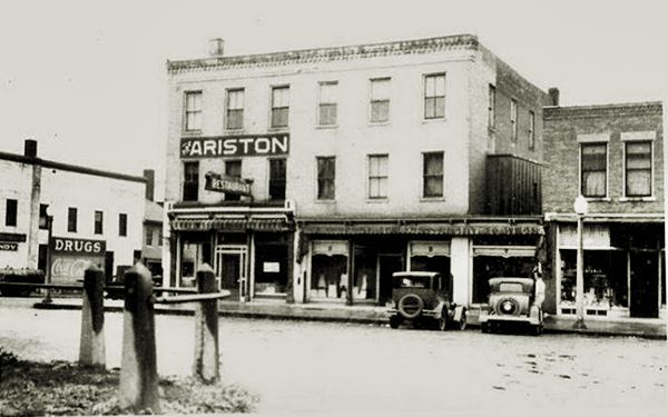
The building was built back in 1854, and is the second oldest one on the Square and the first three story building in town. It is still standing:
Drive eastwards along E Main (original Route 66) and just ahead is the famous Courthouse:
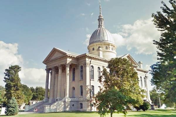
Macoupin County Courthouse
To your right, at 201 E Main St, Carlinville
The Macoupin County Courthouse is known as the "Million Dollar Courthouse" (it actually cost over $ 1.3 Million in 1870 dollars, which is roughy equivalent to $24 million today).
The project promoted by Judge Loomis was budgeted in 1865 at $50,000. A bond was issued and a levy was established to gather the necessary funds. But as time passed the costs rose and by 1869 the project had swallowed almost $ 450,000, and the building was not yet finished -lacking its roof and dome.
Corruption charges were brought against Judge Loomis and the County Clerk and also partner in Loomis' hotel, George Holliday.
The building was completed in 1870 at a cost of $1,342.000.00. A committee was created to investigate the charges and both Loomis and Holliday resigned. But Loomis was later cleared and Holliday vanished from Carlinville without a trace.
The tremendous debt caused by the Corthouse building was repayed over the next 40 years: the final bonds were paid off in 1904.
In 1870, when it opened it was the largest courthouse in the country and it is still in use.
Macoupin County Courthouse in Carlinville, Illinois
Macoupin County Jail
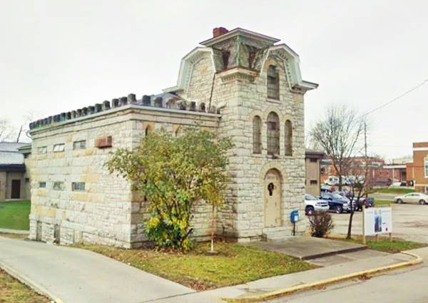
One block south, across the street from the County's Courthouse is the old County Jail at 215 S East St, Carlinville
This castle-like county jail pictured below was designed in Gothic Revival style by E. E. Mayers (who had also designed the courthouse and Loomis' Hotel) in 1867 and completed two years later.
It looks like a castle from the Middle Ages and is known as the "Cannonball Jail" because it was built using embedded cannon balls in the stone walls.
It was built to hold 17 inmates and remained in use until 1988 when it closed. It is closed to the public but there are plans to renovate it and reopen it.
Macoupin County Jail in Carlinville, Illinois
Sleeping Inn motel
Route 66 turned south along S Center Rd. and then took a southwestern course from E 1st St (State Hwy 108). Here on the south side of the road stood the Sleeping Inn Motel. You can see the L-Shaped building in this 1956 aerial photo and this 2015 street view.
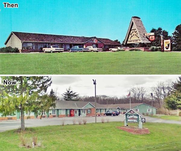
Carlin-Villa Motel
The highway forks to the south along IL-4. Ahead is the Carlin-Villa Motel, from the early 1970s (it does not appear in the 1956 aerial picture), to your right. Below is a then and now sequence:
It is followed (0.4 mi south) by the Original Road Surface, a narrow strip of concrete at the Cemetery, to your left. It was built in the 1920s.
Just beyond the cemetery, to your left is the Macoupin Creek Segment, closed to traffic but accessible on foot.
Continue your Road Trip along Route 66:
This leg of your Route 66 Road Trip along the 1926-30 alignment through Carlinville ends here. Continue your trip by visiting Gillespie, further south along Old 66.

Sponsored Content
>> Book your Hotel in Chicago

Credits
Banner image: Hackberry General Store, Hackberry, Arizona by Perla Eichenblat


