Driving the "Red Brick Road"
Index to this page
Auburn, Illinois full details
Trivia, Useful info & Facts
Elevation: 628 ft (191 m). Population 4,410 (2024).
Time zone: Central (CST): UTC minus 6 hours. Summer (DST) CDT (UTC-5).
Auburn is a town located in Sangamon county, SW from the state capital city of Springfield, in central Illinois.
The History of Auburn
The first inhabitants of what is now Illinois, arrived when the ice sheets retreated some 11,000 years ago, at the end of the last Ice Age. These Paleoindians were the ancestors of the modern Kickapoo, Illinois and Miami natives that were the historic natives encountered by the first European explorers in the mid 1600s.
France claimed the region as part of "New France" (now Canada) but lost it to Britain during the Seven Year War (1763). The independence of America (1776) saw the land change hands again; it became a territory of the U.S.
The first settlers arrived in the mid 1810s and early 1820s, around the time that Illinois gained statehood (1818).
In 1821, Sangamon County was established. It was named after the Sangamon River, which runs through it. the word Sangamon may be a Pottawatomie native word (Sain-guee-mon = "where there is plenty to eat") or a name given by the French explorers (St. Gamo: Eighth century Benedictine monk. Abbot at Noyon, France; he expanded the monastic movement and was a patron of the arts).
It was founded in 1835 one mile north of its present location by Thomas Eastman and sons. The post office opened in 1838 as Sugar Creek but changed a few months later to Auburn.
When the Alton and Sangamon Railroad was built in 1853, the town relocated to its present location by the station then named Wineman, which had been founded by Philip Wineman. This led Asa Eastman son of Thomas to buy Wineman and rename it Auburn.
The name Auburn
Thomas Eastman's daughter Hannah named it for their former hometown Auburn in Androscoggin Maine. Which in turn was namedi after the fictional English village of "Auburn" mentioned in the 1770 poem "The Deserted Village" by Oliver Goldsmith (1728-1774), a critique to the Industrial Revolution. Although it comes from Latin "albus" (white) it morphed to "brown" because 16th and 17th centuries the color was often written abrune or abroun.
Route 66 was aligned through the city following the frist State Highway, SBI 4, in 1926, but it was short lived as in 1930 it was shortened and made straighter, realigned to the east through Litchfield, bypassing Auburn.
Getting to Auburn
Reach Auburn driving along State Highway 4, south of Chatham and Springfield. IL-104 links it to I-55 (Exit 82) and US 66, which are 6 mi. to the east.

Auburn, its Hotels and Motels
Lodging & accommodation in Auburn; sponsored content. Find a room in neighboring Springfield, just a few miles to the north:
> > Book your hotel nearby, in Staunton or Springfield
More Accommodation near Auburn on Route 66
Below you will find a list of some of the towns along Route 66 east and west of this town; click on any of the links to find your accommodation in these towns (shown from east to west):
Along Route 66 in IL
- Hotels in Illinois
- Route 66 Starting point ▸ Chicago
- Lockport
- Willowbrook
- Bolingbrook
- Plainfield
- Romeoville
- Joliet
- Wilmington
- Dwight
- Pontiac
- Chenoa
- Normal
- Bloomington
- Atlanta
- Lincoln
- Springfield
- Raymond
- Litchfield
- Staunton
- Williamson
- Hamel
- Edwardsville
- Collinsville
- Troy
- Glen Carbon
- Pontoon Beach
- Granite City
- East St. Louis
West in Missouri
- Hotels in Missouri
- Florissant MO
- Bridgeton MO
- St. Louis MO
- Kirkwood MO
>> Check out the RV campgrounds in Springfield and Glenarm.
Auburn's weather
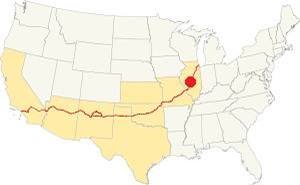
Location of Auburn on U.S. Hwy. 66, Illinois
Auburn's climate is a "humid continental type", its summers are humid, long and hot. Its winters are short, very cold, with a lot of snow and quite windy.
Its average yearly temperature is around 52.4 °F (11.3°C). The winter averages (Jan) are: low 21°F (-6°C) and high 35°F (1.7°C). The average summer (Jul) high is 86°F (30°C), and a low is 68°F (20°C).
Snow falls during more than 4 months with an average snowfall of 22 inches (56 cm) yearly. Precipitation is 35.3 in. (895 mm) per year.
Tornado risk
The are around Auburn may get around 7 tornado strikes each year.
Tornado Risk: learn more about the Tornado Risk on US 66.
Map of Route 66 (1926-30) in Auburn IL
Historic background: Pontiac Trail
The predecessor of Route 66 was the "Pontiac Trail". The use of automobiles grew in during the early 1900s and this led to a public demand for better roads, suitable for cars.
Dirt trails used by carts with deep ruts, which became muddy traps during the rainy periods were not suitable.
A private association was formed in 1915 to promote the Pontiac Trail which became a "solid surface road" that linked Chicago with St. Louis. It was named for the famous Ottawa Indians chief. The B.F. Goodrich tire company marked its milage posts with its custom shield sign (see image).
SBI-4 (State Bond Issue Highway 4
The state government took over and issued a bond in 1918 which created the State Bond Issue highway 4 (or SBI-4) which mostly followed the original Pontiac Trail.
This highway was paved between 1923 and 1926, and that same year, 1926 when U.S. Highway 66 was created, it was aligned along the new IL-4 roadbed.
1926-1930 US 66
This first alignment of Route 66 south of Springfield had a winding course following the former county lanes and lot demarcation trails. It had many sharp 90° curves. This made it unsafe and also longer. The highway ran between Staunton and Springfield and went through Auburn.
Chatham to Auburn
The 4.6 mile trip from Chatham to the Historic Brick Road just north of Auburn is shown in this Map with Directions.
The first part is marked with a violet line in our custom map runs straight, almost parallel to the old railroad tracks to the left (east) it has a soft curve westwards into Alpha Rd. Where the 1926 alignment differs from the current one:
it used to run west along Alpha Rd. for 1000 ft. and then turn sharply south with a 90° curve along a now removed road segment. You can see the missing segments here in our custom map with the black lines at Alpha Rd.
An aerial photo from 1956 shows the missing roadbed.
South of this point (pale blue line in our custom map) the highway curves, but as it reaches Hambusch and Snell Roads there are some remnants of an abandoned stretch of highway to your right.
An abandoned concrete section 1926 US66
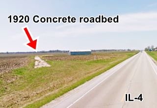
It is 1,280 feet-long with a straight section on the north, and a curve towards the west onto Hambusch Rd.; this part is cracked and lies abandoned in a field (navy blue line in our map). The remaining section along Hambusch Rd. is driveable. (Green line in our custom map).
it was built in Portland Concrete in 1921 and had two eight-foot-wide lanes, narrow by our standards but common in the 1920s. This section is not part of the "Historic Place" that comprises the Brick Road further east. It just lies, forgotten, in a field.
It was indeed part of the 1920 Route 4 and then the 1926-30 US 66. The later 1930s straighter alignment of IL-4 still in use bypassed it. But it remained in use for some time and survived until the mid 1990s (1946 aerial photo see left side).
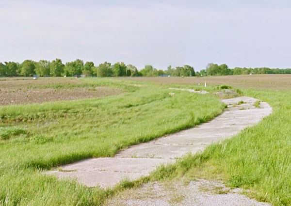
Ahead Hambusch Rd. meets the later Route 66 and continues westwards as Snell Rd. Just ahead is the The historic Red brick section of Route 66 described in detail further down.
> Read more about Brick paved sections of Route 66.
The highway continues south into Auburn but in the 1920s the town had a different configuration: The tracks of the Illinois Traction ran around the town, on its northern side along the south side of what now are Interurban St. and the East-West portion of Lincoln St. Then it curved south along the eastern side of what is now Redbud Lane.
So Route 66 followed Lincoln St. on its north to south portion and then turned west just south of modern IL-4 along the east-west section of Lincoln St. then it followed the NE-SW course of modern IL, but instead of curving south again as it does now, it continued westwards along a now eliminated extension of W. North St. then it turned sharply south along Panther Creek Rd. tp continue south on IL-4 all the way to Panther Rd. You can see this mapped with a gray line in our custom map. This 1946 aerial photo shows this alignment.
1926 USGS map of Auburn IL, Route 66 is the red line onthe right side. Dashed red line marks current IL-4
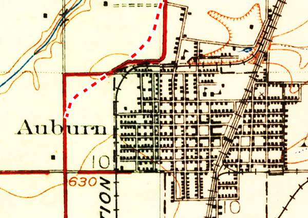
The Route 66 alignment in Auburn
Visit our pages with old maps and plenty of information about US 66's alignments.
- Route 66 Hamel IL to St. Louis MO (Next)
- Springfield to Staunton IL (1926-30 US66 near Auburn)
- Springfield to Hamel IL (1930-77 US66 to the east of Auburn)
- Route 66 Pontiac to Springfield IL (Previous)
Auburn: classic US 66 Sights
Landmarks and Attractions
Driving southwards from Chatham you will reach the famous highway section paved with red bricks. But first another landmark on the north side of Auburn:
Becky's Barn
At the eastern tip of the Red Brick Road, on the north side of the highway at 5029 Snell Rd, Auburn
This antique store sits next to the original 1930s brick road. Beck Hargett, co-owner, passed away in 2015. Its worth a stop.
The Historic Brick Road (Route 66), notice the concrete curb. Auburn, Illinois

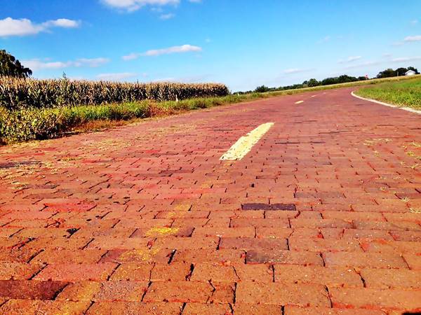
The historic Red brick section of Route 66
Listed in the National Register of Historic Places
See this map with directions along the brick segment.
Illinois state highway 4 ran south from Springfield to Hamel via Chatham and Auburn. It had originally been paved with Portland concrete in 1921. The roadway became US 66 in 1926. Four years later Route 66 was realigned further east via Litchfield and Mt. Olive, removing it from the old IL-4 alignment.
One of the reasons for its realignment was to remove the sharp ninety-degree turns of the old alignment and give it a straighter and safer course.
Red brick Route 66, Auburn Illinois
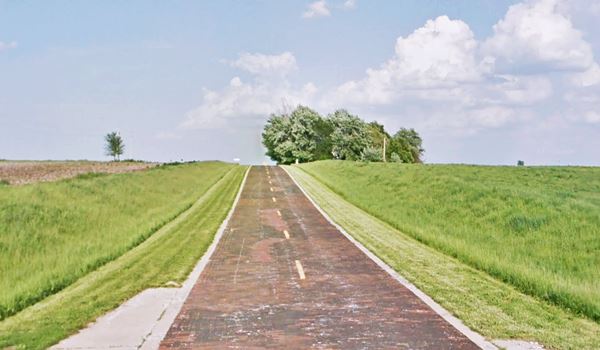
In 1932, during the Great Depression, state hwy 4 was improved. The roadway was widened and many of the sharp 90° curves were eliminated. The Auburn segment was improved and its western part was resurfaced with bricks: the segment that ran along Snell and Curran Roads. The sharp curve at their junction was also softened to a wide arch (9) (10)
The image below shows a detail from the 1924 USGS map of Snell Road north of Auburn and the solid red line marks what in those days was State Highway 4; notice the sharp curves to the right and left (east and west).
The northern part was straightened (red dashed line) bypassing the eastern 90°curve at Hambuch Rd. The old segment here was not upkept and still lies in the fields, cracked concrete, overgrown with weeds (street view of the old concrete section).
The new straight alignment then turned right onto Snell Rd. which was paved with bricks, a soft curve was added at Curran Rd., and this road was also surfaced with bricks.
The current alignment of IL-4 south of Snell Rd. marked with a dashed blue line, with a diagonal course from right Snell to Curran Rds. was not paved until the 1960s; it does not appear in any aerial photograph of this spot (see this 1956 aerial picture as an example) until 1971.
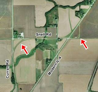
In the 1956 aerial photo you can see the original 1920s sharp curve at Snell Rd. and Curran Rd. (upper left side of image) and the red-brick wider curve built in 1932.

USGS map from 1924, Auburn, Il
The image above shows a curent view of the same spot. The ninety-degree curve on the right (east) is the original 1920s concrete-paved segment between modern IL-4 and Hambuch Rd (red arrow) replaced in 1932. The red arrow to the left is the red brick road's wide curve.
Paving roads with bricks
The Brick Paved Route 66 in Illinois
Dirt or gravel roads in the countryside and the cities were problematic even during the horse drawn cart age: They were uneven, the wheels created ruts that filled with water forming puddles when it rained. Mud slowed down traffic for days until it finally dried.
Stone cobbles were expensive to shape and transport because they were not always available locally. The same can be said about gravel.
Virgil Gates and Mordecai Levi were granted a patent (No. 285,746) in 1883 for their method of building brick pavement roads. Bricks were easy to make, light and provided a good road surface. They became popular in the late 1800s and early 1900s.
Road Construction with bricks
> Read more about Brick paved sections of Route 66.
Initially they were laid on the soil with a sand cushion below and the joints filled with sand. This was inadequate because water passed in between the bricks through the sand joints and loosened the sand bed below.
The solution was to build a concrete foundation, lay a sand cushion on it, place the bricks close together and fill the spaces with a bituminous cement.
Glazed bricks were chosen because they were very durable, also known as vitrified bricks they were impervious to water and corrosion.
Red brick paving at Panther Creek, Auburn Illinois
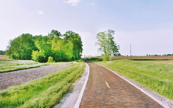
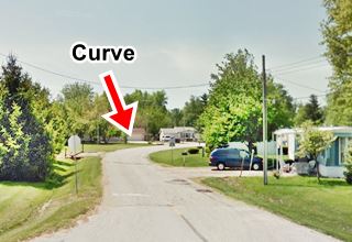
Drive south into Auburn. No old gas stations, diners or motels remain from the 1926 Route 66, however you can follow the first alignment (map with directions) as it curves along Lincoln St. Below is a view of the sharp curve that changed its course from north-south to east-west:
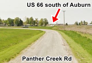
The image above looks south along Panther Creek Rd. it continued straight (now there is a gap in its course caused by the highway being realigned along its present course) southwards you can see how Route 66 continues straight, aligned with Panther Creek Rd.
On the south side of Auburn at the crossroads of IL-4 and IL-104, there have been gas stations since at least 1946 as you can see in this aerial photo taken that year. Where Casey's is now located there was a Deep Rock station in the mid 1960s (aerial picture from 1966).
Continue your Road Trip along Route 66:
This part of your Road Trip along the 1926-30 Route 66 in Auburn ends here, head south along the highway to visit Thayer.
From here, at Casey's it is a 5.8 mile drive eastwards to the 1930-77 Route 66 (see map) between Divernon and Glenarm.

Sponsored Content
>> Book your Hotel in Chicago

Credits
Banner image: Hackberry General Store, Hackberry, Arizona by Perla Eichenblat


