Small Village on U.S. 66
Index to this page
Glenarm, Illinois: all about it
Trivia, Facts and Useful Information
Elevation: 597 ft (182 m). Population 200 (2010).
Time zone: Central (CST): UTC minus 6 hours. Summer (DST) CDT (UTC-5).
Glenarm is an unincorporated community set in Sangamon County, Illinois. The tiny village is located on two Route 66 alignments: the 1930 to 1935 and the 1935-77.
Glenarm's History
The first inhabitants of this area arrived around 12,000 years ago at the end of the last Ice Age. More recently, in the 1600s, when the first French explorers reached Illinois, it was inhabited by Native Americans.
The first white settlers arrived around 1800, and shortly after (1821) Sangamon County was created. Abraham Lincoln represented Sangamon County in the Illinois state Legislature.
The county was named after the Sangamon River, which runs through it; it is probably a Pottawatomie name -they were a local Indian tribe; "Sain-guee-mon" = "where there is plenty to eat". Anothre version is that it was the name of a French saint ("St. Gamo").
In 1879 the Jacksonville Southeastern Railway Company was organized after buying the railroad from Jacksonville to Virden from another company. Glenarm was a depot on this railroad. Glenarm's post office opened in 1886.
The Name:Glenarm
According to Edward Callary in his "Place Names of Illinois" the village's name is of "unknown origin". It probably comes from Glen'Arm' a bathing resort in Antrim, Northern Island because there were many Irish settlers in this area.
The Pronunciation guide for Illinois place names of 1957 (1) says it should be pronounced as follows: "Glenarm (Sangamon) GLEN-ahrm."
Route 66 has run past Glenarm since 1930.

Glenarm, its Hotels and Motels
Lodging & accommodation in Glenarm; sponsored content. Find a room in neighboring Springfield, just a few miles to the north:
> > Book your hotel nearby, in Springfield
More Accommodation near Glenarm on Route 66
Below you will find a list of some of the towns along Route 66 east and west of this town; click on any of the links to find your accommodation in these towns (shown from east to west):
Along Route 66 in IL
- Hotels in Illinois
- Route 66 Starting point ▸ Chicago
- Lockport
- Willowbrook
- Bolingbrook
- Plainfield
- Romeoville
- Joliet
- Wilmington
- Dwight
- Pontiac
- Chenoa
- Normal
- Bloomington
- Atlanta
- Lincoln
- Springfield
- Raymond
- Litchfield
- Staunton
- Williamson
- Hamel
- Edwardsville
- Collinsville
- Troy
- Glen Carbon
- Pontoon Beach
- Granite City
- East St. Louis
West in Missouri
- Hotels in Missouri
- Florissant MO
- Bridgeton MO
- St. Louis MO
- Kirkwood MO
>> Check out the RV campgrounds in Springfield, Lichtfield, and also in Raymond
Glenarm's weather
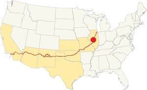
Location of Glenarm on U.S. Hwy. 66, Illinois
Summers in Glenarm are humid, long and hot. Its winters are short, very cold and quite windy.
The winter averages (Jan) are: low 21°F (-6°C) and high 35°F (1.7°C). The average summer (Jul) high is 86°F (30°C), and a low is 68°F (20°C).
Snow falls during more than 4 months with an average snowfall of 22 inches (56 cm) yearly. Precipitation is 37.5 in. (952 mm) per year.
Tornado risk
Sangamon county, where Glenarm is located, is struck by 7 tornados each year. Tornado Risk: learn all about the Tornado Risk on US 66.
Map of Route 66 through Glenarm in Illinois
Route 66's original 1930-35 Alignment to Glenarm
The alignment to Glenarm followed Cotton Hill Road, and it is marked with a green line in our custom map. It begins on the eastern side of the freeway northwest of Toronto, and then curves to the south towards Sugar creek. It passes under the railroad tracks and then is cut off by Springfield lake: the northern section is now submerged under the waters of man-made Lake Springfield created between 1931 and 1935.
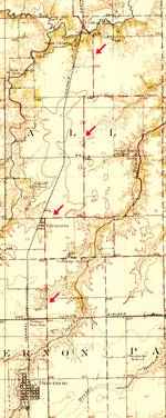
The Mother Road followed state highway 126 from Cotton Hill to Glenarm (map with directions. The course is marked with red arrows in the map (click on the thumbnail map for a full sized veiw) IL-126 was an existing secondary highway that ran between the state capital and Litchfield.
The roadway resurfaces on the south shore of Lake Springfield and runs with a general southern direction with several sharp 90° turns as it heads west into Glenarm.
The thumbnail map is a USGS map published in 1924 and shows the roadway used by the 1930-35 alignment of US 66 from Springfield to Glenarm.
As it reaches Glenarm, the highway is cut by I-55 (no overpass links it to Glenarm here- it is further south), but when Route 66 became a 4-lane divided highway in 1950s, prior to the Interstate system, there was a junction at this point and in this aerial picture from 1946 you can see the junction at Glenarm. Here it took wide curve into a southbound course into Divernon, Farmersville and Waggoner.
1935 Realignment
The completion of the construction of Spaulding Dam across Sugar Creek cut the old road and a new and straighter alignment replaced the old one.
This later 1935-77 course from the Marina to Glenarm is now overlaid by the freeway, but its west frontage Rd and Palm Rd follow the course of the original '66.
Looking west along the 1930-35 Route 66 in Glenarm, Illinois. I-55 runs from left to right in the background.
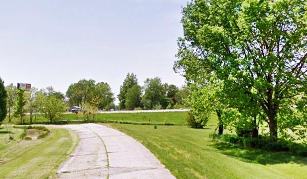
The Route 66 alignment in Glenarm
Visit our pages with old maps and plenty of information about US 66's alignments.
- Route 66 Hamel IL to St. Louis MO (Next)
- Springfield to Staunton IL (1926-30 US66 to the west of Glenarm)
- Springfield to Hamel IL (1930-77 US66 near Glenarm)
- Route 66 Pontiac to Springfield IL (Previous)
Glenarm: classic US 66 Sights
Landmarks and Attractions
Historic Context: The Village back in 1946
Jack D. Rittenhouse drove past Glenarm in 1946 and in his classic "Guidebook of Route 66" he has an entry for it as "Glen Arm" (Yes, he uses two separate words):
A dozen homes... with a few gas stations, stores, cafe, Atchison's garage Rittenhouse (1946)
None of these buildings have made it to our days, or if they have they have changed beyond recognition:
Railroad Overpass
Driving south along the W Frontage Rd. (Palm Road) from Springfield, is a new attraction:
Corvair Museum
"Modern" attraction
The Corvair Museum is located on the original 1935-77 Route 66 between Springfield and Glenarm (2.2 miles north of Glenarm) and 4.5 miles east of Chatham at 10041 Palm Rd., near the Double J RV Campground. It has a lage collection of Chevrolet Corvair models, from regular ones to race cars. More information at their www.corvair.org. This is a map with directions from Glenarm.
Head south, the highway crosses the railroad using an overpass. The first viaduct built here around 1935 was upgraded in 1955 with the four-lane US66. This bridge in turn was replaced in 2011.
Mirror on a Bridge
The 1935 overpass had a mirror placed on the bridge so that those driving up the steep approach ramp could see those coming against them, hidden by the "hill" of the bridge.
This "trafficscope" was patented by Ralph M. Cooley (U.S. Patent No 2,162,160). He described his invention as an " improvement in a highway vision device, of a type designed to pro vide a clear view of the highway to be travelled by
a car, regardless of the curve or change in elevation of the highway. I have found that a great number of accidents which occur on highways are due to one car passing another on a blind hill or while travelling around a curve."
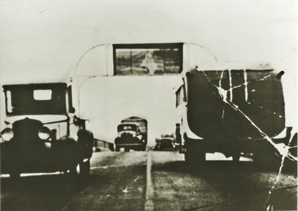
Below is a schematic from the patent:
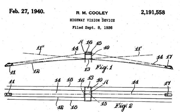
Unfortunately it didn't work as expected because it distracted the drivers and promoted reckless driving. By the way, legislation in 1926 and later did not allow overtaking on hills or curves unless there was an unobstructe view within a distance of 500 feet (2).
Into Glenarm
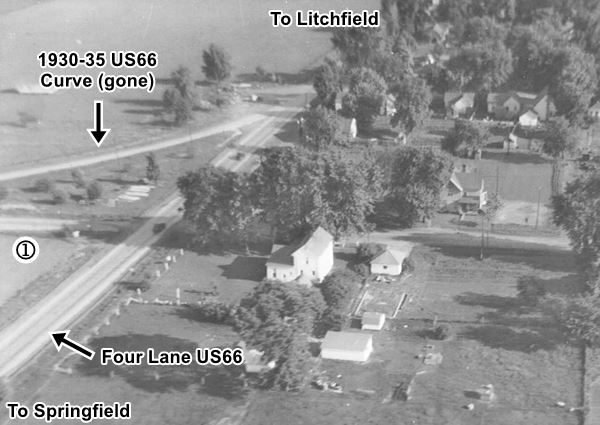
Looking SE across Glenarm 1950s view Source
Click image for full size picture
On the south side of the overpass is the junction with the first alignment of Route 66. The original road had a sharp 90° turn towards the south when it reached Glenarm, marked with (1) in the thumbnail image (click on it for a full sized photo). Later this curve was softened and became an "S", reaching Glenarm at Judd St. as you can see in these aerial photos taken in 1946 (a fork) and 1956 (an "S"). This roadbed was later removed and a new one built in 1971 when the freeway was built along the old 4-lane 66 as you can see in this map.
According to a very old resident, Rosa Atchison-Bryan the town "had 2 grocery stores, 2 motels, 2 filling stations, 1 insurance company, a tavern and a church..."
Murphy's Standard Station
It had "Gas - Groceries - Coins Coin Books and Holders." Originally Charley Arnold's home, Martin Murphy added a garage to its western side and it became a gas station and convenience store. It became Paula's - Glenarm Pub. There were rooms to rent located behind Murphy's
Atchison Station
Dillard Atchison's Shell station was located facing east, next to Judd St., its pumps were very close to the original Route 66 (now the Frontage Rd.) the building has gone. It had a gabled roof as you can see in the picture below from the 1940s:
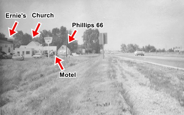
It had a brick outhouse in the back, one side for women, the other for men. Atchison's house was next to the station and faced Judd St.
When the highway was widened Dillard moved the garage to the south side of Gleanarm but in the mid 1950s leased it to Ernie Darling, it became Ernie's garage.
South side of Glenarm

1956 aerial photo South Glenarm. Source
Click image for full size picture
Further south, also along the western side of the highway were the motel, Methodist Church, old post office, and more gas stations.
The thumbnail image is a 1956 aerial view (Springfield and the north is top, Litchfield and south is bottom). Click on the thumbnail to enlarge it. Notice the four lane alignment of Route 66 on the right side of the image. The right lanes are now the freeway's southbound lanes. The left lanes are the current frontage road. The modern I-55 northbound lanes would be located furhter right, in the field on the right side of the picture.
Methodist Church (gone)
On the south side of Robb Street, was the United Methodist Church in Glenarm. This church was built as the Glenarm M.E. Church in 1869.
It was torn down in 2019, you can see it in these two street views: 2016 (standing) and 2019 (gone).
It appears on the upper left side of the 1956 aerial photo.

1947 picture Phillips 66, Glenarm. Source
Phillips 66 Station (gone)
The picture shows the Phillips 66 in Glenarm, with its two gas pumps on the right. It was taken in 1947. This building is very similar to the building that can be seen in the image below taken in 1970. It has a similar gable roof, and southern wall with two windows in it.
The photo below was taken at Route 66 and Rhodes Ave. on the south side of Glenarm in July 1970. It looks north. Work on I-55 was just starting and the buildings next to Route 66:
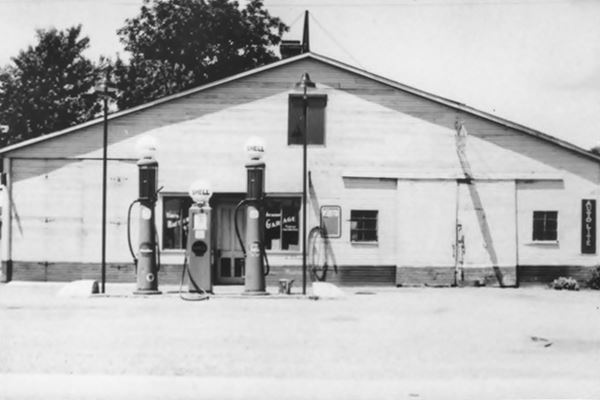
The same spot in 2013, when the Church was still standing:
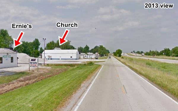
Ernie's Garage & Sinclair Station
The building is still standing, on Rhodes Ave., now it is "Ace Floors" but in those days it was a Sinclair gas station operated by Ernie Darling; he also offered 24 hour tow service.
Motel
Where the Ball Township building is located once stood the "motel" that was ran by the Powers family. The "old" post office was also located here.
This concludes your city tour of Glenarm, but it has two historic attractions not too far from the highway: a round barn and a covered bridg:
Side trip to visit the Round Barn and Covered Bridge
See this map with directions roughly 7.5 miles round trip (20' drive time).
Sugar Creek Covered Bridge
listed on the National Register of Historic Places
The Sugar Creek Covered Bridge which is also known as the "Hedley" or "Glenarm" bridge is one of the 5 remaining covered bridges from the 1800s in Illinois. It was built in 1880.
Sugar Creek Covered Bridge in Glenarm, Illinois
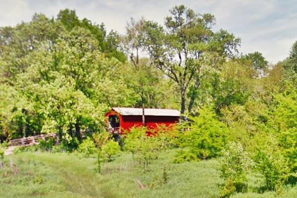
It spans 60 feet across Sugar Creek and was restored in 1965. The historical society of Sangamon County created the "Pioneer Park" next to the old bridge named so after the first settler here, Robert Pullian who arrived in 1817. It is only 2 miles northwest of Glenarm.

Glenarm's Round barn. Source
Round Barn
Glenarm's round barn was built by George Bale in 1913 it is located southwest of Glenarm on private property. Request permissioon to visit it. The trees obstruct the view from the road.
One of the Round Barns on Route 66. There is another Round barn nearby next to I-55 as you head towards Divernon, your next stop on your road trip.
This part of your Route 66 Road Trip in Glenarm ends here, head south along the 1930-77 course of Route 66 to visit Divernon.

Sponsored Content
>> Book your Hotel in Chicago

Credits
Banner image: Hackberry General Store, Hackberry, Arizona by Perla Eichenblat
Memories of Glenarm, Illinois Facebook group
Dale Travis Barns and Covered Bridges
Jack DeVere Rittenhouse, (1946). A Guide Book to Highway 66


