Wacky, Kitschy and Weird sights on Route 66
Index to this page
- About Livingston
- Weather
- Hotels in Livingston
- Map of US 66 in Livingston
- What to see and do in Livingston
About Livingston, Illinois
Facts, Trivia and useful information
Elevation: 620 ft (189 m). Population 889 (2020).
Time zone: Central (CST): UTC minus 6 hours. Summer (DST) CDT (UTC-5).
Livingston is a village in the northeastern section of Madison County, in southwestern Illinois on the 1940-77 Route 66 alignment.
History of Livingston
People have lived in what nowadays is the state of Illinois for over 11,000 years, since the last Ice Age ended. Learn more about the early history of Madison County, following the link.
The first settlers were Mary Jane (1836-1897) and John Livingston (1830-1898) who owned a 297-acre farm. When his parents died, coal was found on their land, and their children led by their son David platted a town on the property in 1905. Its economy was based on the local coal mines despite being in a farming area.
The Name:Livingston
It was named for David Livingston (1873-1927), a member of the family that owned the land where the town was platted.
It is a Saxon name that combines a person's name withhis abode:a man named Leving or Living plus the word "tun" (place, farm), resulting in "Lvigings-tun" or "Livingston."
It was the village where the workers of the New Staunton Coal Co. lived. The company opened in 1904 and closed for good in 1964. At that time the population was 1,445 and since then it has almost halved.
Route 66 was aligned through the town in 1940.

Hotels and Motels: Livingston, Illinois
Find your lodging & accommodation close to Livingston (sponsored content)
> > Book your hotel in neighboring Staunton
More Accommodation near Livingston on Route 66
Below you will find a list of some of the towns along Route 66 east and west of this town; click on any of the links to find your accommodation in these towns (shown from east to west):
Along Route 66 in IL
- Hotels in Illinois
- Route 66 Starting point ▸ Chicago
- Lockport
- Willowbrook
- Bolingbrook
- Plainfield
- Romeoville
- Joliet
- Wilmington
- Dwight
- Pontiac
- Chenoa
- Normal
- Bloomington
- Atlanta
- Lincoln
- Springfield
- Raymond
- Litchfield
- Staunton
- Williamson
- Hamel
- Edwardsville
- Collinsville
- Troy
- Glen Carbon
- Pontoon Beach
- Granite City
- East St. Louis
West in Missouri
- Hotels in Missouri
- Florissant MO
- Bridgeton MO
- St. Louis MO
- Kirkwood MO
>> Check out the RV campground nearby in Douglas
The weather in Livingston
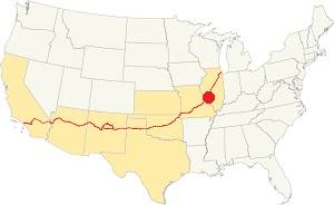
Location of Livingston on U.S. Hwy. 66, Illinois
The Seasons in Livingston: summers are long, warm, and humid; winters are short, freezing, and windy. Temperatures may vary on average between 21°F (-6°C) to 86°F (30°C).
July has an average high of 86°F (30°C), and a low of 68°F (20°C). During winter the average low is 21°F (-6°C) in Jan. and the averag high is a cool 35°F (1.7°C).
Livingston's snowy period lasts for about 4.3 months, with an average snowfall of 22 inch (56 cm) yearly. Rainfall averages 37.5 in. per year (952 mm)
Tornado risk
Livingston may be hit on average by 7 tornados every year.
Tornado Risk: read all about Tornado Risk on Route 66.
Map of Route 66 in Livingston, Illinois
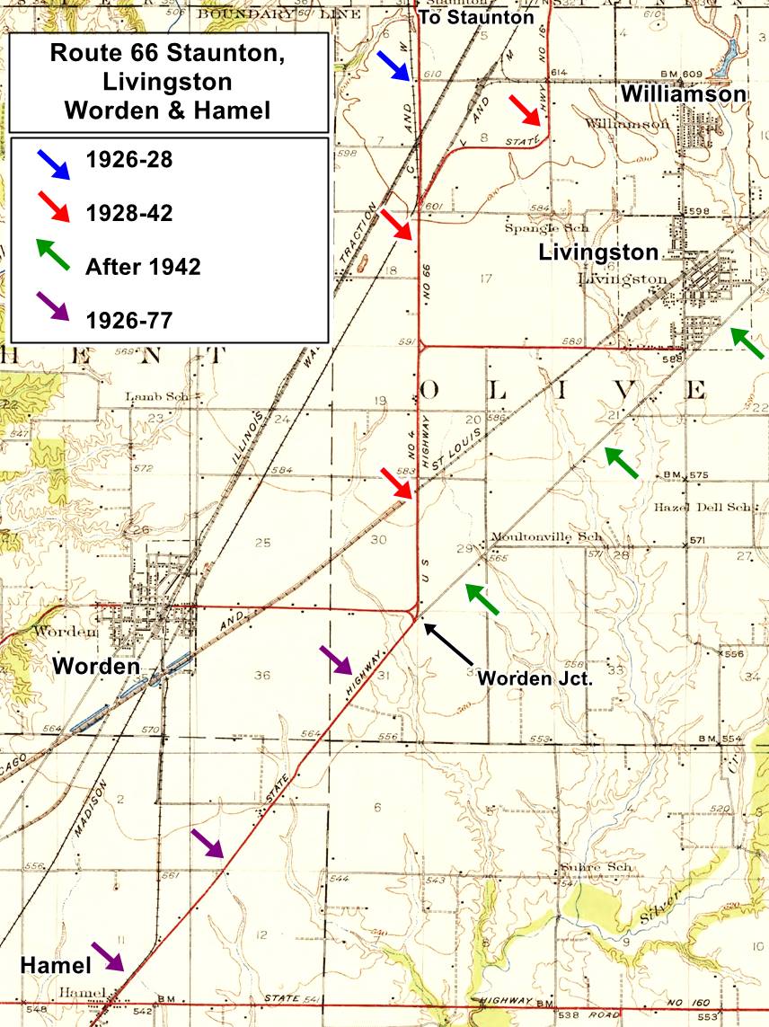
This is the map with directions from the southern part of Mt Olive through Livingston to Worden's Wye.
The first alignment (1926-30) ran to the west of Livingston, through Staunton to Worden's Wye. In 1930 it was moved to the north of Livingston, from Staunton to Mt. Olive. In the 1930s a straighter alignment was surveyed, via Livingston, and a new highay built from Worden's Wye to Mt. Olive along the South side of Livingston. In 1955 it was upgraded to a four-lane highway.
The two maps furher up show how Route 66 was realigned through Livingston bypassing Staunton. The other map shows more details. It is based on a 1932 USGS map. click on the thumbnail to enlrge it.
North of Worden Wye the map shows the original alignment south of Staunton (blue arrow), the 1928-42 Route 66 (red arrows) and the course that Route 66 followed after 1942 via Livingston (green arrows). West of Worden Jct, to Hamel, the violet arrows mark the course of Route 66 from 1926 to 1977.
The Route 66 alignment in Livingston
Visit our pages with old maps and plenty of information about US 66's alignments.
- Route 66 Hamel IL to St. Louis MO (Next)
- Springfield to Staunton IL (1926-30 US66 near Livingston)
- Springfield to Hamel IL (1930-77 US66 east of Livingston)
- Route 66 Pontiac to Springfield IL (Previous)
Route 66 Sights in Livingston
Landmarks and Places to See in the village
In his 1946 classic guidebook to US Highway 66, Jack Rittenhouse described it as follows:
US 66 barely touches the eastern edge of LIVINGSTON (Pop. 1,115). Gas station on highway Rittenhouse (1946)
He mentions the junction four miles west that leads to STAUNTON; (Which is IL-4) here there was gas, cafes and a few cabins (Worden's Wye - we describe it in our page on Staunton). Rittenhouse pointed out that two miles east of Livingston you could see, half a mile to the west, the "workings of the Mount Olive and Stanton Coal Co.".
Drive into the town along the Freeway or, following the West Frontage Rd. south of Exit 41. There are some gaps in the original alignment caused by the construction of I-55 in the late 1960s and you can see them in our custom map marked with blue, black and green lines on the north and eastern side of Livingston.
At Exit 37, on the SE corner of Nichols and Henry streets is the former Amoco that Richard Meyer opened in 1976 after the new freeway cut off the access to his Standard Station on the south side of Livingston. In 1990 he sold it to his sons Steve and Richard A. it became a BP and now it is a Shell gas station.
Meyer's County Inn and Motel
A true entrepreneur, Meyer partnered with H. Jack Frandsen and opened a new 19-room motel and cafe. He bought out Frandsen. The motel is still open
Drive west along the Frontage Rd. which in front of the motel has a Historic 1940-77 US 66 sign (pictured).
Site of Kendon Motel
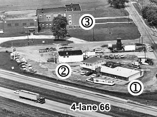
Marked with a (1) in the picture (click to see full size view) The gable roof building to your left on the SW corner of the Frontage Rd. and Veteran's Memorial Dr (902) has a history dating back over 80 years.
The first building on this site was Scheibe's Cafe, ran by Ann Sheibe of Edwardsville. It opened on the new 1940 alignment. It was bought by Elmer "Beb" SAndrin in the 1950s and changed its name to Sandrin Cafe. The students fromthe High School across Livingston Ave. gathered here after basketball games.
Then it was the Fud Cafe under Shirley and Adolph Hebenstreit. Finally it was purchased by Kenney and Don Ackerman who named it "Kendon" (blending their first names), it grew into a motel and a restaurant with a nice triangular neon sign; it promoted itself as "One stop for Modern Accommodation and Delicious Food."
It burned down and a new building replaced it, first as Joe's Auto Repair (2004) now as After Life Custom Cycles.
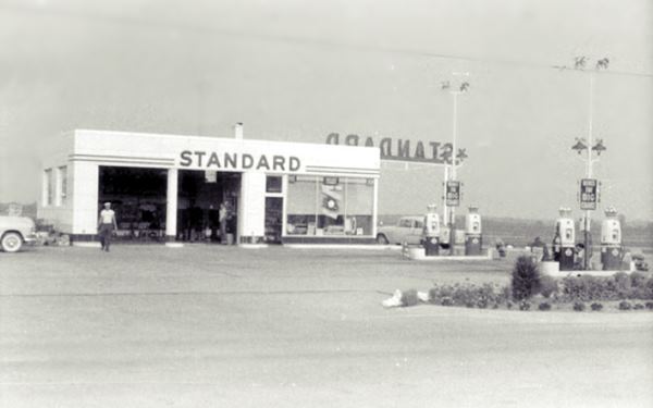
Bowles and Meyer Standard Station
It is (2) in the aerial photo, facing the High School (3). Richard Meyer and Robert "Doc" Bowles opened it in 1956 on the new four-lane 66. They ran it until 1975 when the original four lane divided highway was replaced by the modern freeway. The freeway's limited access design eliminated the grade crossing at Livingston Ave. and replaced it with the exit 1 ⁄ 4 mile further east, cut off from its customers the place closed. Meyer opened a new gas station at the exit, a BP station that is still there, a Shell, at Nichols and Henry by the County Inn Motel.
Four Lane 66
If you look at the aerial photo carefully you will see that there is no Frontage Road, only two westbound lanes running past the gas station and Kendon's Motel, plus two eastbound lanes separated by a median grass strip.
This was a 1950s type of "superhighway" it had divided sets of lanes, but it also had grade crossings. One of them was next to the high school (see it in this Aerial Photo from 1968).
These crossings were dangerous so the interstate system was built with grade separations such as overpasses or underpasses at limited access and exit points.
Pink Elephant Antique Mall
Across the street, at 908 Veterans Memorial Drive. Facing the former gas station on Livingston Ave.
Americana, Wacky sights and Route Kitsch
This antique shop offers a wide assortment of vintage collectibles, memorabilia and antiques, but is best known for its gigantic fibeglass statues.
Below is a panoramic view of the old High School building, and its outdoor attractions:
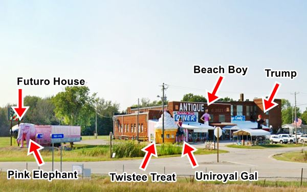
High School Building
The first high school opened in Livingston in 1917. The first building was built one year later and the current red-brick building was completed in 1927. The gymnasium with an Art Deco-style was completed in 1949.
Funding and budget issues became critical in the 1980s and finally the town voted to dissolve the local school district and annex it to Staunton's in 2005.
The building has a second life now, as an antique mall. The word "Gymnasium" can be seen over its entrance facing Livingston Ave.
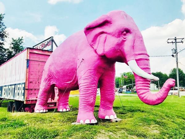
The Pink Elephant

Fiberglass elephant in FAST Corp's brochure. Source
On the eastern tip of the property, facing the freeway. It is one of the many fiberglass animal statues -including gray elephants- on the propery. This one is an oversized statue (though smaller-than-life-sized) Indian or Asian elephant, painted bubblegum pink.
It was produced by a company based in Sparta, Wisconsin, called Sculptured Advertising in the 1970s. They are now known as FAST Corp. and specialize in fiberglass statues. Their website's product catalog displays the twelve-foot-tall (4 m) elephant as its model #7045. The wrinkles on trunk and legs as well as ear shape are identical to those of the pink elephant.
This is the "statue" of the Pink Elephant at the Antique Mall in Livingston, Illinois
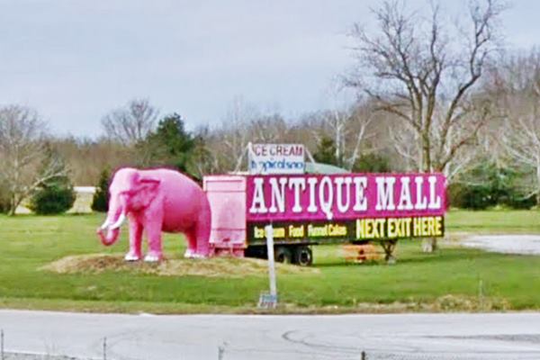
Why is it pink?
Circus owner P.T. Barnum brought a "white elephant" to America in 1884 but it wasn't white, it was pink and it caused dismay among the audience. The media wrote about it, placing the term "pink elephant" in the public mind.
Jack London wrote about the hallucinations of a alcoholics in his novel "John Barleycorn" published in 1913 as follows: "the man... who sees, in the extremity of his ecstasy, blue
mice and pink elephants..." (read the full text).
Pink elephants became the euphemism for the drunk hallucinations provoked by delirius tremens. Disney's character Dumbo is portrayed in the 1941 movie in a drunk scene, seeing pink elephants.
Another US66 Pink Elephant: the one in Fenton MO
There is another Pink elephant in Fenton MO very close to Route 66 as it approaches St. Louis.
The UFO: a Futuro House
On the left side of the elephant is a lentil-shaped object looks like a flying saucer (UFO, or as they are now called: UAP - unidentified aerial phenomena), actually it was designed in 1968 by Finnish architect Matti Suuronen as a portable ski cabin, compact and easy to heat.

Futuro House blueprint. Source

Futuro House "UFO" in Livingston IL by Route 66. Source
It was built with fiberglass to make it light and strong. It only had sixteen components so it was easy to transport and assemble, ideal for rocky mountain terrain. It was 26' diameter (8 m) and 13' high (4 m). Around 100 of them were sold and over half of them have survived. The concept failed due to raising costs of plastics in the early 1970s, public resistance to its futuristic design and limited field of use. The one at Livingston, was originally painted green. The structure has been restored as you can see in the image above by Chris Robleski
Twistee Treat Diner
Head towards the main building, on its eastern tip is the Twistee Treat Diner that started with the old fibreglass cone, and then added a seating area annexed to the main red-brick building flanked by the Uniroyal Gal and the Beach Boy.
Large sculptures at Twistee Treat diner
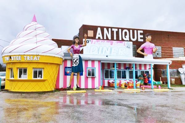
Giant ice cream cone
Robbert "Skip" Skinner opened his first Twistee Treat in Fort Myers, Florida, in 1982 and expanded it into a chain with scores of locations. It went bankrupt in 1990 and the name and rights to the brand reverted to the franchisees. Nowadays the brand has been revived by a company based in Orlando (their website).
The giant fiberglass ice cream cone with a soft ice cream topped with a cherry was the creation of Skinner. It is 28 ft. tall (9.2 m) and 20 ft. wide (6.1 m). They were made in
Uniroyal Gal
Uniroyal began in 1892 as the United States Rubber Company, it adopted the name Uniroyal Inc. in 1961 and in 1990 was acquired by Michelin. In the late 1960s it launched "Miss Uniroyal", an 18 foot-tall fiberglass statue that held up a Uniroyal tire in her upraised left hand and a bikini, later toned down to a less provocative skirt and blouse.
The public knew them as the "Uniroyal Gal". She was produced by The International Fiberglass Co, of Venice, California. Hundreds of these 250 pound sculptures were produced before the advertising campaign ended around 1970.
As no copyright had been registered, International Fiberglass kept on producing them as "Miss America". The typical 1960s Jackie Kennedy styled flipped bob haircut gives the Uniroyal Gal a vintage look.
This "gal" has a Route 66 shield on her apron and also has superhuman measurements (108-72-108); if she had the height of an average American woman (5' 4") she'd measure 32 - 21.3 - 32.

Uniroyal Gal. Livingston IL. Source

Beach Boy. Livingston IL. Source
Beach Boy
To the right of the Uniroyal gal, this "Beach Boy" also appears on the catalog of FAST Corp (item #8001) he is taller than his female companion, standing 26 feet tall.
He sports bathing trunks and an ice cone in his left hand. There are several versions about where he came from (neighboring Benld, or a bar in the Soulard district of St. Louis), but here he is, on Route 66.
Trump statue
The entrance is located under the word "Gymnasium" in Art deco font. On the right side of the door is a statue of former President Donald Trump with MAGA hat, dark suit, red tie and a white shirt.
Harley Davidson Muffler Man
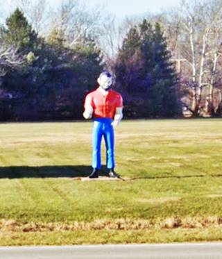
On the southern side of the property, facing Route 66 is its Harley Davidson Muffler Man, wearing a short-sleeved orange shirt with the words "Harley Davidson" written across his chest. The sides of his black boots have the Harvey Davidson shield-logo on their outer sides.
He is one of Route 66's 15 foot-tall eye-catchers from the past. It was made by International Fiberglass. This one was inside the shop in the past and wore different clothes (blue shirt, gray pants and his name was Hank.
The concrete base is dated 2010.
>> Learn more about the other giant Muffler Men on Route 66
This part of your journey ends here. Continue your Route 66 Road Trip westwards towards Worden Wye and visit Hamel.

Sponsored Content
>> Book your Hotel in Chicago

Credits
Banner image: Hackberry General Store, Hackberry, Arizona by Perla Eichenblat
Livingston Centennial
Pink Elephant mall


