Route 66 in Wildwood, Mo
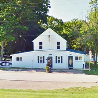
Big Chief Cabins nowadays
Index to this page

TheRoute-66.com is reader-supported. When you buy through links on our site, we may earn an affiliate commission at no additional cost to you.
About Wildwood Missouri
Facts, Trivia and useful information
Elevation: 755 ft (230 m). Population 35,517 (2010).
Time zone: Central (CST): UTC minus 6 hours. Summer (DST) CDT (UTC-5).
The town of Wildwood is located on the original 1926 - 1932 alignment of Route in western in St. Louis County, central-eastern Missouri.
History of Wildwood
Eastern Missouri has been inhabited for the last 10,000 years. In 1683, French exporers from Canada reached the area and encountered Algonquin natives who called themselves "Illiniwek" (meaning "men" in their own language); they were hunters and also grew crops of beans, corn and squash. They were named "Illinois" by the French.
This territory was named Louisiana after the French King, Louis XIV. Two frenchmen,Laclede and Chouteau founded St. Louis in 1764. In 1803 a cash strapped Napoleon, ruler of France, sold the territory to the U.S., and shortly after, settlers began arriving.
St.Louis incorporated in 1809 and in 1813 the US government established the Territory of Missouri, which became a state in 1821. In 1830s the Native Illiniois and other tribes were forcibly relocated to reservations in Oklahoma to make room for European settlers.
Shortly after, the main "State Road to Jefferson City", linking St. Louis with the state capital was built through what is now Wildwood. A stagecoach ran along it (now MO-100 and US-50 highways). Small communities sprang up around the taverns, inns and stores that serviced the stagecoaches. And that is how the communities of Grover, Pond, Fox Creek, and Hollow came to be.
Route 66 was created in 1926, along the older main highways. It passed through the area until 1932, when it was realigned to the south through Eureka and Pacific.
The City of Wildwood is far more recent, it was born after the citizens in the area united to defeat an expressway along MO-109 (The "Outerbelt", which would have damaged the environment and promoted a strong urbanization in this forested region. Then, emboldened by their success, they fought to incorporate as a city to have more strenght to defend their local interests. The western part of St. Louis county incorporated in 1995 and adopted the name "Wildwood". The name Wildowood has no relationship with US 66 during its heyday. However, four out of ten small communities that united to form the city, do have a common history with Route 66.
The Name: Wildwood
The committee seeking incorporation considered several options (Rockwood, Parkland and Green Hills) but chose "Wildwood" because it combined "Wild" from Wild Horse Creek in the north with "Wood" from the Rockwoods Range and Reservation in the south. A name that spanned the entire region.

Where to Lodge in Wildwood, Missouri
Accommodation and hotels near Wildwood
> > Book your accommodation in neighboring Eureka
More Lodging close to Wildwood along Route 66
There are several hotels in the area close to this town. Alternatively you can also find your accommodation along Route 66 in the neighboring towns and cities in Missouri. We list them below (from east to west):
On Route 66's Main alignment in MO
Eastwards
Westwards
- Hotels in Kansas
- Baxter Springs KS
- Galena KS
- Riverton KS
- Hotels in Oklahoma
- Miami OK
>> Check out the RV campground in neighboring Fenton
Weather in Wildwood
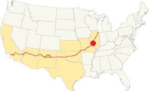
Location of Wildwood on U.S. Hwy. 66
Wildwood has four well marked seasons. It is located in the area where humid continental climate shifts towards a humid subtropical climate, so summers are hot and humid while winters are cold. It gets cold Arctic air and hot damp tropical air from the Gulf of Mexico. Spring is wet and may have extreme weather (tornados, thunderstorms and even winter storms). Fall is sunny and less humid, with mild weather.
Rainfall averages around 41 in. (1.041 mm). The most rainy months are from May through July with more than 4.1 in per month (104 mm). Snow falls from Nov. to Apr.: 17.8 in. (45 cm). Relative humidity is on average 69.7% roughly the whole year. The average winter high (Jan) is a chilly 39.9°F (4.4°C) and the winter low is on average 23.7°F (-4.6°C). The summer (Jul) average high is 89.1°F (31.7°C) and the average low is 71°F (21.7°C).
Tornado risk
The town is located in Missouri's "Tornado Alley" and St. Louis County has around 7 tornados each year.
Tornado Risk: read more about Tornado Risk along U.S. 66.
Map of Route 66 through Wildwood, Missouri
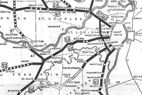
The map below shows what is now Wildwood, in the central part of the map, between Ballwin and Grays Summit, notice that it does not name any of the small communities along it. The dark black line indicates that it was paved at that time (1931). The following year it would be replaced by the new alignment running through Eureka and Pacific.
Map 1931 showing US66 into St. Louis
Follow this map with US66 alignment in Wildwood (the latest alignment).
You can also see the alignment of US 66 in this town on our Missouri Route 66 Map, it has the complete alignment across the state with all the towns along it.
The Route 66 alignment in Wildwood
Visit our pages with old maps and plenty of information about US 66's alignments.
- Gray Summit to Rolla (next)
- Route 66 St. Louis to Gray Summit (In Wildwood)
- Route 66 Hamel IL to St. Louis MO (previous)
Route 66 Sights in Wildwood
Wildwood and its Route 66 attractions
As we mentioned above, Wildwood is located the 1926 -32 alignment of US 66 and at that time was a series of separate villages in the forested hills west of St. Louis. So we will describe the Route 66 attractions and landmarks driving east to west from Grover, through Pond, Fox Creek, and Hollow.
Historic context, the classic Route 66 in Wildwood
The the WPA travel guide (The WPA or Works Projects Administration was a New Deal agency during the Great Depression) "Missouri, a guide to the "Show Me" state" published in 1941 only mentions Pond, which had 150 residents at that time. It said that it was settled in 1815 and "was named after and adjacent millpond." It recommended the nearby Dr. Edmund A. Babler Memorial State Park, for hiking and camping.
Wildwood Route 66 Tour
The classic Route 66 west of Ballwin and Ellisville ran through open countryside, it wasn't urban or suburban as it is today.
We will begin our tour where MO-100 becomes a divided highway, at Hutchinson Rd. in Elisville (which didn't exist when Route 66 ran through this are). See Map; drive west.
The Old Route 66 on Ruck Rd.
Just 0.2 mi ahead, Ruck Rd. curves to the south in a wide arch. Modern MO-100 was built later, and straighter, so the old segment has been cut off from the main alignment. It ends in a dead-end; this map shows the part that you can drive and in yellow, this map shows the missing section.
Head back to the main highway head west, at the point where Manchester Road forks to the south there is another change in the original alignments: At first it followed the course marked in blue, before Route 66 was created. Then it was straightened out and aligned along the orange line. You have reached the first of the villages along the old US 66: Grover.
Grover
Grover, the name
Named after Stephen Grover Cleveland (1837-1908), who served as the 22nd (1885-1889) and 24th (1893-1897) president of the United States (the only one to serve two non-consecutive terms as president).
The post office opened in 1889 during Cleveland's first term, and the postmaster named the village after the president.
Grover is a Germanic name that means "ditch or grave digger" (Grove = hollow - grave), in England it was also someone who lived near a grove.
Former gas station: Larry's Tavern
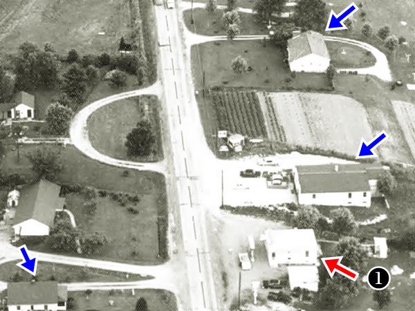
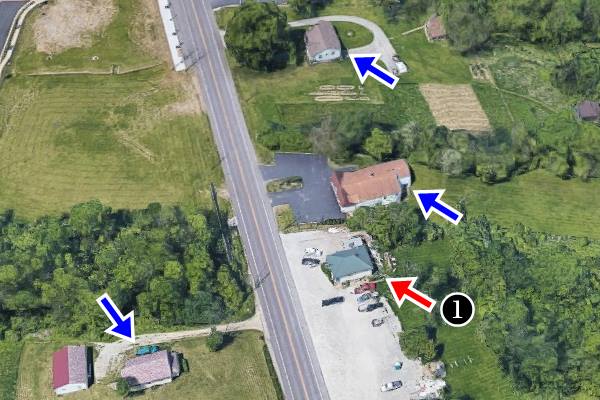
Drive 2 miles west to a surviving set of buildings from the "old days", you can see them below in a "Then and Now" view from the air. The buildings marked with the blue arrows are still there, the one marked (1) with the red arrow was a gas station, the pumps are clearly visible in the 1940s photo. Now it is a bar (Larry's Tavern at 16833 Manchester Rd). Pumps and all signs of former gas station have vanished.
Eastern Grover ca. 1940s, US 66 runs from top (west) to bottom (east)
Eastern Grover nowadays old US 66 runs across the center of the image
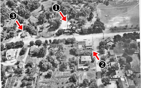
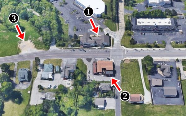
Continue west for 0.3 mi. and at Eatherton Rd. you will find some more historic Route 66 buildings; see the "Then and Now" sequence below. Further down we describe them.
Central Grover ca. 1940s, US 66 runs from left(east) to right (west)
"Downtown" Grover now. Old US 66 runs left to right across the image.
Rettker's House, 1879
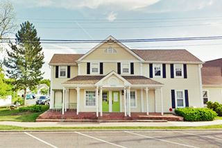
To your left -marked (1) in the air views, is a two story building at 16962 Manchester Rd. It was built by Fred Rettker in 1879. It was a general store also. In 1890 Louis Fick bought it, and it also housed the local phone company in 1911. From 1995 to 2009 it was Wildwood's City Hall.
Wetterer Smith Shop, 1865
Facing Rettker's is a long one story building, on the right side of Route 66, at 16957 Manchester Rd - NE corner, marked (2) in the aerial views. It was the local blacksmith, owned by Freidlien Wetterer, a German migrant who arrived in St. Louis in 1854. He made wagons in Ballwin and after the Civil War moved to Grover (1865), built is shop there and also acquired an 84 acre farm. The building is still standing.
The final building in the aerial pictures marked with (3) has been torn down. The lot is currently vacant. It appears to have been a gas station with a gabled canopy over the gas pumps.
Pond
Continue westwards along Route 66 for 1.8 miles, and at Pond Rd. you leave Grover and enter the small rural community of "Pond".
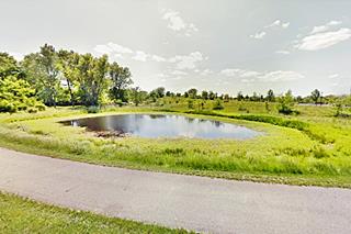
This hamlet is located on land that was originally settled by John Brockman in 1835, later Cyrus Speers owned a tavern and store here, and the place was known as Speer's Pond (the pond is just north of the village - see picture). Later Frederick Drienhofer, a German, bought the land and more Germans settled there they built the buildings that you can see in the township.
Pond Inn ca.1910
The Inn is to the left, at 17250 Manchester Rd. on the SE corner of Manchester and Pond Rd.
It is also known as Pond Hall, it was originally a Tavern (1875), by 1910 William Kesselring owned a store and bar here, and the "Kesselring's Hall and Grove" next door. It was also known as "Wayside Inn" and "Pond Inn". The building still stands today.
Pond Inn nowadays
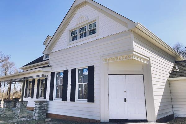
Pond Hotel - Torn down
The now vacant lot on the SW corner of Manchester and Pond Rd. facing Pond Inn was the site of the now demolished Pond Hotel.
The stagecoach service from St. Louis to Jefferson ran along Manchester road and stopped at the Pond Hotel which was built between 1840 and 1851 on the site of Brockman's store.
It became a post office in 1878 and was upgraded to a very decent hotel in 1911.
It was a popular place for cyclists and a restaurant operated here until the 1950s. Despite attempts to repurpose it in the mid 1990s, it fell into disrepair and collapsed, so it had to be torn down. A piece of American history was lost!
St. Louis Cycling Club Monument
At the western tip of the former Pond Hotel's front garden is a small stone monument (Street View), it was erected by the St. Louis Cycling Club (STLCC) founded in 1887 and the oldest consistently active cycling club in the US.
It says "POND - This stone erected by the St.Louis Cycling Club 1923 to preserve upon the highway the memory of an
ardent cyclist William M. Butler Educator, Traveler, and Nature Lover, whose associations with this spot were always congenial and Distinctive".
Kern Service Station
Wildwood Historic Registry
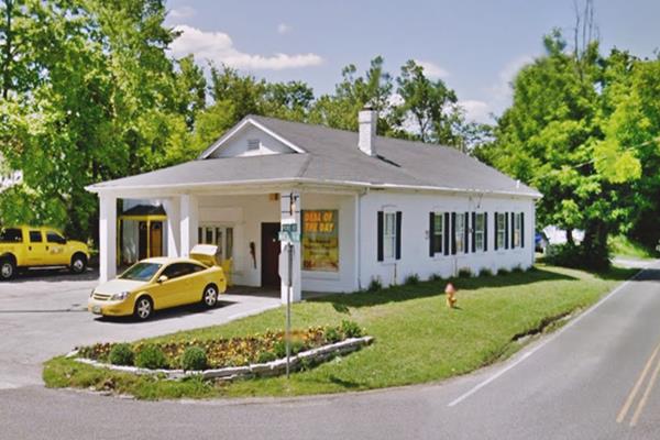
On the NW corner, at 17301 Manchester Rd and Pond Rd. Kern Service Station was built ca.1925. by John A. Kern (1870-1948). He owned a wagon shop here and was a blacksmith. He saw change coming and adapted to the automobile as his wagon and horseshoe business declined.
Nowadays it is a store, but the canopy over the now gone pumps is clearly visible.
Kern Filling Station, Pond MO as it is today
Pond Texaco Gas Station
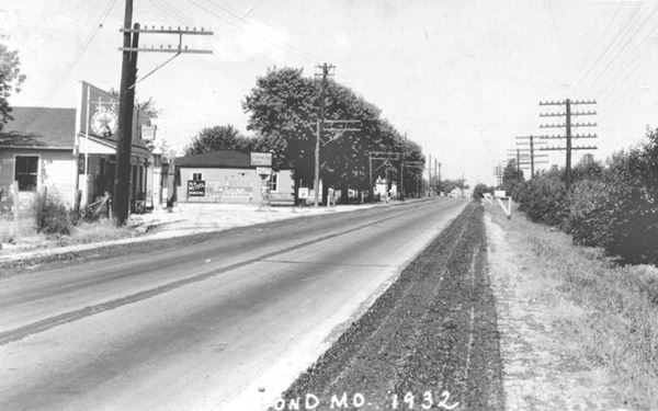
Continue west, and to your left, just 200 yards west is another old gas station (17301 Manchester Rd).
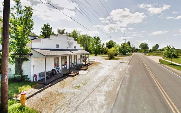
Below are two views of the old Texaco gas station, in the 1940s and now. The "Western false fron", a flat vertical facade with a square top in the 1940s, used to hide the gable roof is now "stepped", with steps as it narrows towards the top. The long and narrow porch roof is unchanged.
Gas station on Historic Route ca. 1940.
Gas station on Historic Route 66 nowadays
Big Chief Restaurant
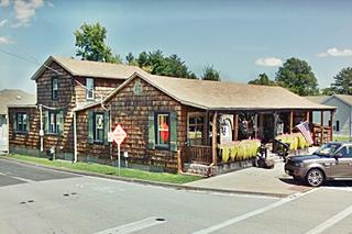
Just 0.2 miles ahead to your left (17352 Old Manchester Rd.) on the south side of the road is the historic "Big Chief Cabin Hotel", now the "Big Chief Roadhouse."
Listed in the National Register of Historic Places
Street view of the former Chief Hotel in Pond, Wildwood, Missouri
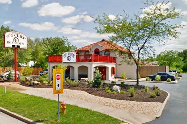
click image for Street View
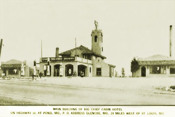
Old photo 1932 of the Big Chief Cabin Hotel, in Pond, Wildwood, Missouri

This Spanish Mission Revival styled building opened in 1928, it was built by William Clay Pierce, partner of Pierce-Pennant Oil Co.
Mr. Pierce had the vision of building integrated self-contained stopping points along Route 66 from Chicago to Los Angeles. They would include a luxurious motor-hotel, restaurant, and a full service gas station. He opened the first one in Springfield Missouri, followed by one in Rolla, and this one in Pond. By 1929 there were more in Texas and New Mexico. But the Great Depression hurt business in 1930 and Pierce sold out to Sinclair Refining Co. Hard times hit the company and it went bankrupt in 1933.
This hotel was known as the "Big Chief Hotel" or "Chief's Cabin Hotel" and the "Big Chief Dakota Grill". In 1946 it became Mike Aceto's Café 66. At one time a false steeple crowned the building, but it was removed in 1959.
It wasn't a hotel though, it was a "cabin hotel", with 62 cabins, each with its garage with hot and cold water showers. The front arched canopy served as a Sinclair and then as a Conoco gas station.
It remained popular after Route 66 was realigned because it hosted dances and was a venue for conferences. The restaurant closed in 1949. The cabins were demolished in the 1970s. But in the 1990s the Restaurant reopened and you can eat a great meal in the famous Big Chief Roadway.
Head west. After 1.1 miles the road curves towards the south and, one mile further on went through the hamlet of Fox Creek.
Fox Creek
It has a few homes and is located on the original Route 66 alignment, which here is Manchester Rd and not MO-100. The place is named after a very large fox that was shot here during its early days, when Josiah McClure from Kentucky settled the spot in 1819.
The remains of his home and the McClure cemetery are still there. The post office opened in 1851. There was a skirmish here on March 7, 1862 during the Civil War, which turned back a Confederate incursion.
At Fox Creek the highway does not follow MO-100, this is the map with the Route 66 alignment in Fox Creek.
Fox Creek Garage
This old garage and gas station is located at 18130 Manchester Rd. Henry Gaehle opened the first garage here in 1917. In 1920 his nephew, Edward Schott bought it and expanded the premises, he called it "Fox Creek Garage".
Old photo Fox Creek Garage, Wildwood, Missouri
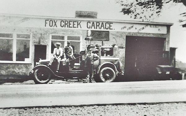
Ed Schott at first worked as a Ford dealer, then in 1927 he won a Pontiac dealership. In the 1940s he renamed it Schott's Garage. Below is a "Then and Now" of Schott's Fox Creek garage and dealership.

Schotts Garage 1970s. More images
Ahead the old Route 66 meets MO-100 again, and both head with a southwestern course. After 1.3 miles it reaches "Hollow".
Hollow
Named "Deutsch Hollow" after the German settlers and a hollow valley. First settled by Charles Paffrath in 1834 who owned a tavern on the busy highway, later a stop of the St.Louis and Jefferson City stage coach line. A post office opened in 1884 and closed in 1904.
Charley Pfaffrath opened a store and tavern which later became Hencken's Grocery Store.
Stovall's Grove roadhouse
The main attraction is Stovall's, a bar and a dance hall at 18720 Stovall Lane. "Country Music Hall since 1935" is what it states on its advertisements. George and Mollie Stovall bought the land in the 1930s and opened the tavern in 1935. The building can be seen below in 1959, and nowadays, with the two wings, one on each side. There is a statue of a stallion by its entrance.

Stovall’s 1959. Enlarge image
Old US 66 Alignment in Hollow
There is an old Dead End Alignment on Stovall Road that is only 0.2 miles long, this Map shows the part that can be driven and this Map shows the gaps in the alignment (in orange).
Head west, and 1.2 mi. ahead is another abandoned section of Route 66.
Old Dead End Alignment of Route 66: Deer Creek Rd.
Short stretch, to your left. This is the Map of 1926-32 alignment, later shifted north to straighten the highway.
Old Alignment along "Old Manchester Rd."
Just ahead, Route 66's original alignment and modern MO-100's alignment take different courses. The original US66 forks to the right and runs along Old Manchester Road and Deer Creek Rd. in a wide circle to the north and then south again, see this map. At Locust Lane it followed a now eliminated segment shown in this Locust Lane map in violet.
Later, MO-100 was straightened and the current roadbed built.
Beyond this point you leave Wildwood, and the old Route 66 continues to Gray Summit where it meets the later (1932 - 1977) Route 66 alignment, it is a 5.4 mile journey (Map with directions).
Your road trip along Route 66 in Wildwood ends here.
Old Route 66 in Wildwood
From Wildwood to Gray Summit
Route 66: created in 1926
US highway 66's original alignment from 1926 to 1932 ran through what is now Wildwood with an east-west course from St. Louis, through Kirkwood along Manchester Rd. and therefore avoided having to cross the Meramec River between St. Louis and Villa Ridge.
1933-1977 alignment Route 66
In 1932 a shorter and straighter alignment was built routing the highway along Watson Rd. This paved highway required two bridges to cross the Meramec, one at Sylvan Beach, to the west of Wildwood and another at Times This road is now partly overlaid by I-44 west Sunset Hills. West of Gray Summit, the original road was maintained from 1926 to 1977.
There were many Route 66 alignments in St. Louis itself.
Some abandoned segments
The former Route 66 was US-50 for some time, and later became Missouri highway MO-100 and it was improved over the following decades. These improvements straightened the old US 66 out and cut off some former sections of Route 66 roadbed that we have described further up.
> > See the previous segment St. Louis to Wildwood (east - 1926-32 US 66)
> > See the next segment Villa Ridge to St. Clair (west - 1926-77 US 66)
Some sponsored content
> > Book your Hotel in Lebanon

Credits
Banner image: Hackberry General Store, Hackberry, Arizona by Perla Eichenblat
The Ramsay Place Names File
Terry Schott History of a Rural Pontiac Dealership
Esley Hamilton St. Louis
County West Inventory of Historic Buildings, Phase II: Pond and Grover. 1989


