Route 66 in Maplewood, Mo
Index to this page
- About Maplewood
- Maplewood's Weather
- Hotels and accommodation
- Map of US 66
- What to see and do in Maplewood

TheRoute-66.com is reader-supported. When you buy through links on our site, we may earn an affiliate commission at no additional cost to you.
About Maplewood, Missouri
Facts, Trivia and useful information
Elevation 505 ft (154 m). Population 8,046 (2017).
History
James Sutton arrived in St. Louis in 1819, from New Jersey, he was a blacksmith. In 1826 he bought some land and built a log cabin on current Commonwealth Ave. When the "Road to Jefferson City by way of Manchester" opened through is land, he built his home and store next to it (now 7453 Manchester).
A village sprung up in the area which was named after the woods there, with many maple trees. It grew into a suburb of St. Louis, just beyond the city limits but linked to it by streetcar lines. It was a bedroom community after the 1890s, with fresh air and none of the smog of the city.
It has many early 20th Century buildings, from the days when US66 ran along its Main Street.
Getting to Maplewood
Reach Maplewood driving the historic 1926 - 1932 Route 66 now known as Missouri State Highway 100, or use Interstate I-44. I-270, US 50, US 61, I-55 and I-64 cross the area.

Hotels & Motels near Maplewood
Accommodation and hotels close to this town: just west is Kirkwood you will find plenty of motels and lodging options.
> > Book your accommodation in the area: Bridgeton, St. Louis, or Kirkwood
More Lodging near Maplewood along Route 66
There are several hotels in the area close to this town. Alternatively you can also find your accommodation along Route 66 in the neighboring towns and cities in Missouri. We list them below (from east to west):
On Route 66's Main alignment in MO
Eastwards
Westwards
- Hotels in Kansas
- Baxter Springs KS
- Galena KS
- Riverton KS
- Hotels in Oklahoma
- Miami OK
>> Check out the RV campground in Fenton
Weather in Maplewood
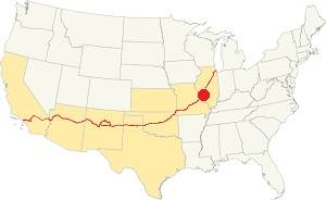
Location of Maplewood on U.S. Hwy. 66
Rainfall in Maplewood is, on average 41 in. (1.041 mm). The most rainy months are from May through July with more than 4.1 in per month (104 mm). Snow falls from Nov. to Apr.: 17.8 in. (45 cm). Relative humidity is around 70%.
Maplewood has four well marked seasons. It is located in the area where humid continental climate shifts towards a humid subtropical climate, so summers are hot and humid while winters are cold. It gets cold Arctic air and hot damp tropical air from the Gulf of Mexico. Spring is wet and may have extreme weather (tornados, thunderstorms and even winter storms). Fall is sunny and less humid, with mild weather.
The average winter high (Jan) is a chilly 39.9°F (4.4°C) and the winter low is on average 23.7°F (-4.6°C). The summer (Jul) average high is 89.1°F (31.7°C) and the average low is 71°F (21.7°C).
Tornado risk
Maplewood is inside Missouri's "Tornado Alley" and St. Louis County has around 7 tornados each year.
Tornado Risk: read more about Tornado Risk along U.S. 66.
Map of Route 66 in Maplewood Missouri
When Route 66 was established in 1926, it was aligned along Manchester Road west of St Louis (now MO-100) to Gray Summit, through Brentwood. The map below published in 1931 shows this alignment. In 1932 its alignment was moved south through Pacific, Eureka and Sunset Hills bypassing Maplewood.
Map 1931 showing the original US66 into St. Louis
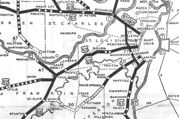
See this map showing the 1926-32 alignment of Route 66 through Maplewood, only 1.4 miles long.
The Route 66 alignment in Maplewood
Visit our pages with old maps and plenty of information about US 66's alignments.
- Gray Summit to Rolla (next)
- Route 66 St. Louis to Gray Summit (In Maplewood)
- Route 66 Hamel IL to St. Louis MO (previous)
Route 66 Sights in Maplewood
Landmarks and Places to See
Driving west from St. Louis towards Kirkwood, the first classic landmark is an ancient garage:
Ozark Trail Garage
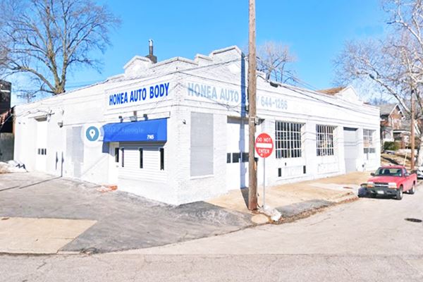
To your right, on the corner, at 7145 Manchester Rd.
The 1993 Detailed Survey of Route 66 landmarks identified this garage as the Ozark Trail Garage (SS.002), a gas station.
It was built around 1924 and it was operated by Charles Creighton as the "Ozark Trails Garage", after 1940 it served as a lumber company and a food warehouse.
It became an auto body shop in 1962.
The brick building has a two-bay service garage topped with a stepped parapet wal with saddleback coping (the bricks along the edges of the parapet). Notice the three diamonds and the horizontal bands of bricks on the walls.
Ozark Trail Garage nowadays, Maplewood MO
Drive west into the downtown area and see the old theater.
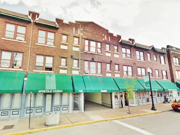
The Maplewood Theater building
To your left, on the 7100 block of Manchester Rd.
Built in 1926, the same year Route 66 was aligned through Maplewood. It could seat 1,079 spectators and was part of the Franchon & Marcon chain.
The brick building had an Art Deco style front and the building included apartments above the theater. It closed in 1967 and its auditorium demolished (now a parking lot). The lobby and entrance became a store.
Former Maplewood Theater, Maplewood MO
Head west, on the NW conren of Manchester and Sutton Blvd. is a classic drugstore.
Katz Drugstore
To your right, at 7401 Manchester Rg is the building of Katz Drugstore. It later became the "Monarch" restaurant and now is a store. The original brick building is still standing. Below is a "Then & Now" secuence of image, notice the neon cat with whiskers and neon bow tie in the postcard
Katz Drugstore in a vintage postcard, Maplewood MO
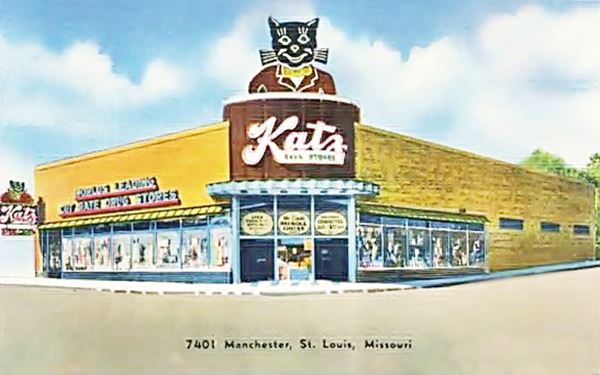
Katz began in Kansas City, as a cigar stand in the Union Station, then expanded under the ownership of Isaac and Michael Katz. The chain was acquired by Skaggs Drug Centers in 1970 and later was bought by Osco that was in turn acquired by CVS.
Former Katz Drugstore in 2021 MO
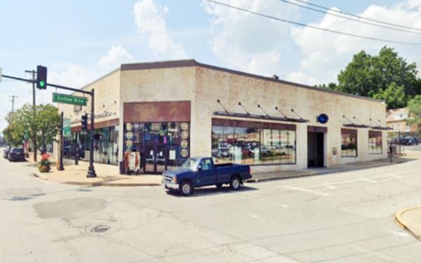
Your Route 66 Road Trip through Brentwood ends here, continue your trip by driving west into Brentwood.

Some sponsored content
> > Book your Hotel in Lebanon

Credits
Banner image: Hackberry General Store, Hackberry, Arizona by Perla Eichenblat

