Small Village with an Opera House beside U.S. 66
Index to this page
- About Farmersville
- Weather
- Hotels in Farmersville
- Map of US 66 in Farmersville
- What to see and do in Farmersville
Learn all about Farmersville, Illinois
Trivia, Useful Information & Facts
Elevation: 639 ft (195 m). Population 664 (2024).
Time zone: Central (CST): UTC minus 6 hours. Summer (DST) CDT (UTC-5).
Farmersville is a tiny village next to Route 66, in Montgomery County, Illinois.
History of Farmersville
This area was first settled some 12,000 years ago at the end of the last Ice Age. Later Illinois indians lived in the area, at the time when the first European explorers reached the area. These were French in the late 1600s.
The first pioneers reached what is now Montgomery County around 1800 and Montgomery County was created in 1821 and named for General Richard Montgomery, an American Revolutionary War hero, killed in 1775 during a failed attempt to capture Quebec, Canada.
The Bois d'Arc township was created on 970 acres of land, entered by Lewis Thomas in 1851. Farmersville was founded in this township in 1893 when the Illinois Central Railroad buitl its line through the area.
The Name:Farmersville
Named for the community of farmers who lived off the very fertile soil of the area.
Irish Days
Many Irish settled in this region, and became a strong influence in the village's character. There is a local festival, the Irish Days which takes place on the second weekend of June from Thursday to Saturday.

Farmersville, its Hotels and Motels
There is no Lodging & accommodation in Farmersville, but you can find your hotel in neighboring Litchfield. Sponsored content.
> > Book your hotel nearby in Litchfield
More Accommodation near Farmersville on Route 66
Below you will find a list of some of the towns along Route 66 east and west of this town; click on any of the links to find your accommodation in these towns (shown from east to west):
Along Route 66 in IL
- Hotels in Illinois
- Route 66 Starting point ▸ Chicago
- Lockport
- Willowbrook
- Bolingbrook
- Plainfield
- Romeoville
- Joliet
- Wilmington
- Dwight
- Pontiac
- Chenoa
- Normal
- Bloomington
- Atlanta
- Lincoln
- Springfield
- Raymond
- Litchfield
- Staunton
- Williamson
- Hamel
- Edwardsville
- Collinsville
- Troy
- Glen Carbon
- Pontoon Beach
- Granite City
- East St. Louis
West in Missouri
- Hotels in Missouri
- Florissant MO
- Bridgeton MO
- St. Louis MO
- Kirkwood MO
>> Check out the RV campgrounds in Lichtfield and also in Raymond
The weather in Farmersville
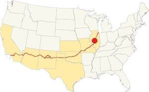
Location of Farmersville on U.S. Hwy. 66, Illinois
Summers in Farmersville are humid, warm and long while winters are short and freezing as well as windy.
The average summer (Jul) high is 87°F (30°C), and a low of 68°F (20°C). The January (winter) average low is 21°F (-6°C) and the avg. high is 36°F (1.7°C).
Snow falls during 4 months and Farmersville's average snowfall is 22 inches (56 cm) per year. The yearly rainfall is 37.4 in. (950 mm)
Tornado risk
Farmersville is in an area struck by some 7 tornados each year. Tornado Risk: learn more about the Tornado Risk on US 66.
Map of Route 66 through Farmersville, Illinois
The original 1926 to 1930 alignment of Route 66 followed State Higway No. 4 and ran to the west of Farmersville from Staunton to Springfield. The nearest town on that alignment is Girard, 7 miles west of Farmersville (map with directions).
1930-1940 US 66
In 1930 the road was moved to the east and realigned along state highway 126; it was a shorter and straighter course from Worden Wye in the south to Springfield in the north. The road now passed by Farmersville.
This is the map of Route 66 between Farmersville and Waggoner (4.7 miles along the West Frontage Road).
1930-77 Ghost segments in Farmersville
The 1930s and the later 1940 Route 66 is now under the W Frontage Road, but there are two ghost segments in Farmersville.
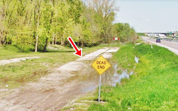
One is on the north side of Macoupin creek, the old Route 66 ran along Witt St. and headed south towards the creek. This is a dead ent as the old bridge over the creek is gone.
Take the West Frontage Road that runs parallel to the old road. It crosses the stream with a bridge dating back to 1949 and visit the south end of this ghost segment.
It is on the south side of Macoupin Creek, beside the Frontage Rd.; it has a Dead End sign:
Original roadbed of US 66 by Macoupin Creek, Farmersville, Illinois
This is the map of Route 66 in Farmersville.
The Route 66 alignment in Farmersville
Visit our pages with old maps and plenty of information about US 66's alignments.
- Route 66 Hamel IL to St. Louis MO (Next)
- Springfield to Staunton IL (1926-30 US66 to the west of Farmersville)
- Springfield to Hamel IL (1930-77 US66 near Farmersville)
- Route 66 Pontiac to Springfield IL (Previous)
Farmersville's classic US 66 Sights
Landmarks and Attractions
The Town in 1946: Historic Context
Jack de Vere Rittenhouse mentions the village in his 1946 classic (Guidebook of US 66) as follows:
US 66 barely touches the eastern edge of the town... Pop. 550; gas, cafes, Cundiff garage... Rittenhouse (1946)
He also mentioned a Gas Station one mile north of the town (now gone -Studebaker Ave.) and another four miles north of Farmersville was a junction leading to Virden : "another gas station, cafe and 8 cabins" (current Virden Ave., also gone). Both were razed when the freeway was built on the eastern side of the four-lane '66.
Coming from the north along the West Frontage Road, the original 1930 roadbed was disturbed by the interchange of Mine Ave. (IL-17) at Exit 72. On the southern side of the exchange, after crossing Main St., follow the road back towards the freeway and visit a classic motel.
Art’s Motel and Restaurant (Closed)
On W Frontage Rd. at Farmersville by Exit 72 (Map)
Illinois Route 66 Hall of Fame
Originally there was a cafe and gas station here run by the Hendrick's brothers. Art McAnarney leased it from them in 1937 and added cabins to it.
His "Art's Motel and Restaurant" was successful (below is a postcard with a 1951 postmark on it):
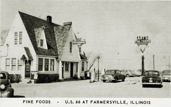
This building suffered a fire in 1952 that burned the second floor. Art rebuilt it as a one-floor building.
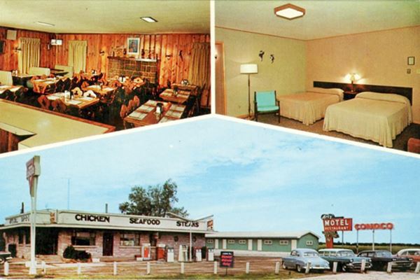
The postcard below (although it has some 1950s cars in it) reads: "One Stop Service. MOTEL - New in 1960. Ultra-modern with individually controlled Electric Heat. Free TV. RESTAURANT - Art's Fine Foods under the same management for 25 years. SERVICE STATION - Conoco Gas and Oils. On U.S. 66 - Twenty Mi. South of Springfield at Farmersville, Illinois Phone 7-2371 Elmer and Joe McAnarney Owners."
Notice the Neon sign on the right next to the Conoco sign.
Postcard of Art’s Motel and Restaurant in Farmersville, Illinois
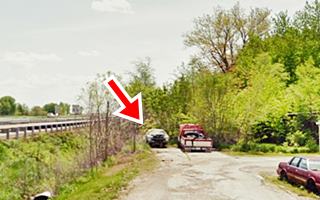
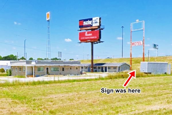
Below is the current view of the same buildings; the small "Conoco" sign is gone. The motel sign stood where the red arrow is, beneath the large signpost that at one time had a Conoco sign:
Present view of the old Art’s motel and restaurant in Farmersville, Illinois
After Art's death in 1957 his sons Elmer and Joe kept the business going, they added an "L" shaped motel with 13-rooms in 1960.
It was linked to the four-lane US 66 by Marin St - IL-17 that ran by the south side of the premises. The highway wasn't a limited access road, it had grade crossings as you can see in the image below (click on the thumnail to enlarge), an aerial photo from 1967. Notice the field behind the motel where the interchange ramps are now located. Both images are looking towards the NW:
The other image above shows the interchange, a gas station to the left, a taller Conoco sign on the right and access to I-55 cut off on Main St. The motel survived the opening on I-55 because the Exit at Farmersville was located next to it.
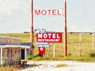
Art's Motel Neon Sign
The neon sign is a classic from the 1950s. A red main frame like an inverted "L" with the words "MOTEL" and "RESTAURANT" written in white capital letters. A bubble-shape on the upper corner with the word "Art's" in white script-like letters against a dark blue backgound and a blue box beneath the main body, also with white letters stating "COCKTAILS AIR COND".
The original neon sign's south face was restored by volunteers of the Illinois Route 66 Association in 2007 and it stood untouched beneatht the tall Conoco Sign as you can see in the late 1960s postcard. The tall sign lured the freeway traffic to their Conoco gas station.

Art's Motel sign nestled beneath the tall Conoco one
Removed and relocated in two places
In 2018 the north facing part of the sign was removed and now is being preserved by a Springfield sign company (Ace Sign Co.) Its neon has been repaired but the rusty faded metal hasn't been repainted. You can see it in the image, in their vintage-themed bar.
The southern part of the sign was taken to the Route 66 Motorheads Bar & Grill in Springfield. The place has plenty of Route 66 memorabilia and artifacts. This is a good addition to their collection, you can see it on the wall next to the staircase in the "Motordome" (red arrow in the picture).

Art's sign at Ace Signs, Springfield Source

Art's sign at the Motordome, Springfield Source
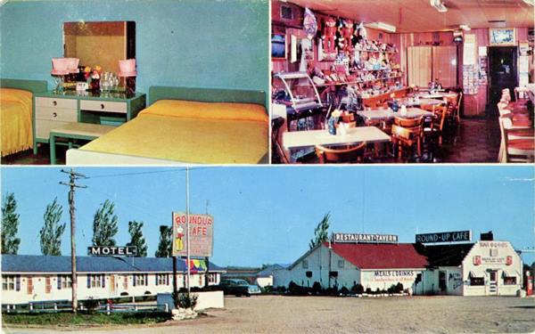
Roundup Motel (Gone)

1967 aerial photo Roundup motel. Notice the grade crossing of Main and US66
Click thumbnail image to enlarge
This motel and restaurant-tavern was located opposite Art's, on the SE corner of Main and the northbound lanes of the 4-lane Route 66. When the freeway was built, the place was torn down to make space for the new northbound lanes (the old northbound lanes became the new soutbound lanes of I-55, and its southbound lanes in turn became the west frontage road).
The McGaughey brothers operated the place that also ad a Texaco gas station and a motel that grew from 13 to 17 units. This aerial photo from 1956 shows Art's on the upper left side of Main and the 4-lane '66 and Roundup on the lower right side.
Its postcard proclaimed "Roundup Cafe and Motel 13 Modern Units - Cafe - Tap Room - Gifts - Souvenir - Complete Auto Service McGaughey Bros., Owners."
On then north side of Main, (NE corner) was a Mobil service station, that was also razed when I-55 was built, so it moved a few hundred feet east. You can see it in this street view and in a aerial photo from 1976.
The Farmersville Muffler Man
The McGaughey Brothers bought the Lauterbach Tire Man of Springfield in 1963 and brought it to their motel.
Erected in 1962, the Tire Man was a Muffler Man styled after Paul Bunyan and it was an eye-catching element for the tire business owned by Russ Lewis on State and Laurel in Springfield Illinois it held a tire in its right hand. He sold it shortly after.
The Roundup had the Muffler Man until it closed in 1978 when I-55 razed the property. But the Lauterbach giant still survives (having changed the tire for an American flag, and you can see it on Wabash street in Springfield, IL) because the Lewis family acquired it again for their shop. (1)
>> Learn more about the other giant Muffler Men on Route 66
Downtown Farmersville
A few blocks west of Route 66 are the old red-brick buildings of the commercial district. Two of them are quite intersting:
Hendrick's Chevrolet
To your right at 604 Main Street, a red brick faced building with white stone details. At one time it said "Hendrick's Chevrolet" on its facade and had a single gas pump on the sidewalk as you can see in this photo from 1983 and its street view in 2021. Now it is closed.
Opera House
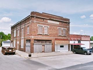
On the next street south, at 516 Elevator St. and S Cleveland (NE corner). The two story red-brick opera house was built in 1911 and had been vacant and abandoned for decades. A local entrepreneur, Cassi Rovey bought it and opened her www.shoptherootedhome.com home decoration, styling and apparel shop here and restored the old building (pictured above in its decrepit state).

Opera House is now a store, Farmersville. The Rooted Home
This marks the end of your Route 66 Road Trip through Farmersville, continue your journey by heading south along the 1930-77 alignment into neighboring Waggoner.

Sponsored Content
>> Book your Hotel in Chicago

Credits
Banner image: Hackberry General Store, Hackberry, Arizona by Perla Eichenblat
Jack DeVere Rittenhouse, (1946). A Guide Book to Highway 66


