
Site of Ariston Cafe
Index to this page
- About Litchfield
- Weather
- Hotels in Litchfield
- Map of US 66 in Litchfield
- What to see and do in Litchfield
All about Litchfield, Illinois
Trivia, Useful Information & Facts
Elevation: 693 ft (211 m). Population 6,626 (2020).
Time zone: Central (CST): UTC minus 6 hours. Summer (DST) CDT (UTC-5).
Litchfield is a town on two Route 66 alignments in Montgomery County in Illinois.
History of Litchfield
Human beings have lived in Illinois since the retreat of the glaciers at the end of th last Ice Age some 12,000 years ago.
Few European and Americans pioneers lived here in the early 1800s. At that time Kickapoo Indians lived here. They were displaced later to the west, across the Mississippi into Missouri by settlers.
Congress awarded land to the 1812 War veterans 160 acres of "Soldiers Bounty Lands" in the Territory of Illinois, some of which was in what would become Montgomery County.
The Name:Litchfield
Named after the founder of the town Electus Bachus Litchfield. The surname comes from an ancient Briton name which during the Roman conquest of Britain became known as Letocetum. It means 'gray wood'. Welsh (a Briton language) recorded it as llwyd 'gray' and coed 'wood'. Anglo English morphed it to 'Licced'and added feld 'pasture' so it means "a clearing in the forest".
Montgomery County was created in 1821 and named for General Richard Montgomery, an American Revolutionary War hero, killed in 1775 during a failed attempt to capture Quebec, Canada.

Mr. Electus Bachus Litchfield Source
In 1853, The Litchfield Town Co. was established to lure the Terre Haute, Alton, and St. Louis Railroad to come through the area. It did. And the town was named after Electus Bachus Litchfield born in New York, a member of the town consortium.
The post office which opened in 1850 and named Hardinsburg; it was changed in 1855 to Litchfield.
It incorporated in 1896. A town based on oil and farming. Route 66 was aligned through it in 1930. Its Population peaked in 1960 at 7,330.

Litchfield, its Hotels and Motels
Lodging & accommodation in Litchfield; there are many options, so you can find a room easily.
> > Book your hotel in Litchfield
More Accommodation near Litchfield on Route 66
Below you will find a list of some of the towns along Route 66 east and west of this town; click on any of the links to find your accommodation in these towns (shown from east to west):
Along Route 66 in IL
- Hotels in Illinois
- Route 66 Starting point ▸ Chicago
- Lockport
- Willowbrook
- Bolingbrook
- Plainfield
- Romeoville
- Joliet
- Wilmington
- Dwight
- Pontiac
- Chenoa
- Normal
- Bloomington
- Atlanta
- Lincoln
- Springfield
- Raymond
- Litchfield
- Staunton
- Williamson
- Hamel
- Edwardsville
- Collinsville
- Troy
- Glen Carbon
- Pontoon Beach
- Granite City
- East St. Louis
West in Missouri
- Hotels in Missouri
- Florissant MO
- Bridgeton MO
- St. Louis MO
- Kirkwood MO
>> Check out the RV campground in Litchfield
Litchfield's weather

Location of Litchfield on U.S. Hwy. 66, Illinois
Summers in Litchfield tent to be humid, warm and long while winters are short and freezing as well as windy. The average temperatures range from 21°F (-6°C) to 86°F (30°C).
The average summer (Jul) high is 86°F (30°C), and a low of 68°F (20°C). The January (winter) average low is 21°F (-6°C) and the average high is 35°F (1.7°C).
Yearly precipitation is around 37.5 inches (951 mm) and snowfall is 22 inches (56 cm)
Tornado risk
Litchfield is in an county that is hit by about 7 tornados per year.
Tornado Risk: learn about the Tornado Risk on US 66.
Route 66 map in Litchfield
The original Route 66 ran 8 miles west of Litchfield along what is now State Hwy. 4. In 1930 it was realigned along the highway that linked Litchfield with Springfield (IL-126), following a straighter and shourter course. In the 1940s it was upgraded to a four-lane divided highway roadway and finally decertified in 1977.
We describe the highway south of Springfield to Litchfield from 1930 to 1977 in a special page with full details, maps and pictures. Here we will follow it through the city, from north to south.

At Washinton Rd. looking north at old Route 66 SB lanes. Litchfield Il. Click for street view
South of N 14th Ave (see picture) the old westbound lanes of the 4-lane '66 are visible as you approach Washington Rd.
Overhead Bridge and "S", gone
Beyond the fork, the 1950s and 1930-40 alignments fork: the 1930 Route 66 took a turn and ran south for 0.4 miles (Map with directions) and then took a wide "S" course to cross the tracks using an "overhead" bridge.
The black and white aerial view below looks from the NE to the SW and you can see the original course along Washington Rd., at the site of the Overhead Cafe are some buildings, on the western side of the highway. Beyond, further west was the 4-lane 1950s alignment, and on the eastern side, the "S" of the 1930 Route 66 crossing the railroad (See the purple line in our custom map).
The "S" alignment and the bridge across the tracks was removed in 1990. The Southbound lanes of the 1950s alignment were erased in the early 2000s; only the former NB lanes survive as "Historic Route 66" ( shown with a yellow line in our custom map.)
Adapted from an image by Vintageaerial.com

See this Same view nowadays (3D Satellite image).
Below is a map with the curved 1940-40 Route 66 in red and the later 4-lane US66 (dashed line). The other image is a satellite view with the trace of the old overpass marked with red arrows.

USGS 1944 map of Route 66 on the north side of Litchfield

Satellite view old alignment, Litchfield, Il. Click to see view
Route 66 in Litchfield

Route 66's 1930-40 and later alignments in Litchfield, Il. USGS 1944 map
Click image for full size map
1930-40 Alignment
The original alignment ran north to south across Litchfield along what is now known as "Old Route 66", see the pale blue line in our custom map and also this map with directions.
1940-55 Route 66
Listed in the National Register of Historic Places
The heavy traffic along Route 66 during World War II required a better, stronger and wider roadbed, so a new 24-foot wide and 10 inch thick, two-lane road in concrete was built in 1943 just to the west of the existing highway (the 1930 US 66); it ran along what is now Columbian Blvd.
The original highway carried the northbound traffic, and the new road became the southbound lanes.
The thumbnail map image shows a detail from the 1944 USGS map of Route 66 in Litchfield (click on it to see a full sized version). The alignment in bright red on the right is what we call the 1930-40 Route 66 or "Old Route 66" however it appears incomplete! There are several "missing" sections where the road does not appear on the map. We have marked them with a dashed red line. The map correctly marked the new alignment (deep red line) to the left.
The project called for a completely new four-lane road to be built, replacing the original Route 66, but it had to wait until the end of the war to be completed with four lanes along Columbian Blvd. (1956 aerial photo)
On the south side of Litchfield, the northbound lanes merge into the former southbound ones becoming a simple two-lane highway. The former northbound lanes are closed to traffic, old slabs of concrete with weeds growing through the cracks. The old abandoned northbound lanes run all the way to Mt Olive next to the lanes that are still open to traffic (See the green line in our custom map).

The Route 66 alignment in Litchfield
Visit our pages with old maps and plenty of information about US 66's alignments.
- Route 66 Hamel IL to St. Louis MO (Next)
- Springfield to Staunton IL (1926-30 US66 to the west of Litchfield)
- Springfield to Hamel IL (1930-77 US66 near Litchfield)
- Route 66 Pontiac to Springfield IL (Previous)
Litchfield: its classic Route 66 Sights
Attractions & Landmarks
Historic context: Litchfield in 1946
In his 1946 classic "A Guide Book to Highway 66", Jack D. Rittenhouse drove along US 66 from Chicago to Los Angeles. And in it he described Litchfield as follows:
gas; cafes; a few tourist cabins; garages: Hittmeier Bros. and Oldsmobile; hotel...This is an old mining town, and was also the locale of early oil production Rittenhouse (1946)
Your Road Trip across Litchfield
Site of Varner Brothers Motel
Drive southwards along the original 1930-40 Route 66, from N 15th Ave. Here Shirley and Ellis Varner purchased famland and built the "Varner Brothers Motel" themselves, in 1950, 3 miles north of Litchfield on the west side of the four-lane 66. It was torn down when I-55 was built over it (location map). They added a cafe ("The Subway") and a Standard Service Station. Nothing remains. See them in this 1967 aerial photo, looking west.
Continue south, at the fork of both alignments at Washington Rd. once stood a Phillips 66 and a Cafe (1967 aerial photo). Take the left branch (1930-40 US66), ahead is the "S" at the "Overhead":
Overhead Cafe
"The Overhead" began in 1948, it was owned by Charles Aikman and Trauman Felts. It got its name because it was just north of the overhead bridge across the Chicago, Burlington, and Quincy railroad. They moved an old downtown grocery store to the spot and served their specialty, "Chicken in the Basket". These were very popular: they sold 8,000 each year. They also sold gasoline.
The old alignment, and the overpass are gone, and another building stands on the site, below is a "Then and Now" sequence:

Head for the southern tip of the "S" (map with directions), and turn south along Old Route 66. The first surviving "classic" from the golden days is the old drive in theater that is still alive and kicking!
Sky View Drive In Theatre

Skyview neon sign at night. Source
To your left, at 1500 North Historic Route 66. You can learn all about it at its website www.litchfieldskyview.com
It opened on June 15, 1950. Don't miss its classic neon sign, and right next to it is a Scenic Byway "Wayside Exhibit" that tells you about the history of this Route 66 classic.
Neon sign of the Sky View Drive In Theatre in Litchfield, Illinois
Skinny's Cafe
Ahead, to your right at 1117 N Old Route 66 "South of the Overhead" as its postcard says, was a classic cafe, opened in 1935 by Arthur Large and his wife. They moved to this location in 1939 after a fire burned their original cafe. It was a truck stop and offered meals 24 ⁄ 7. It closed for good in 1958 and nowadays is a mobile home dealer. Arthur was a corpulent chubby man and Skinny was his nickname.


Yates Motor Sales

Yates in a 1950 advertisement. Source
Ahead, after crossing W Ferdon St., to your left you will spot a long single floor, flat roofed building with many service bays and a central office. It was an auto dealership.
Its advertisement from 1950 (pictured) gives its phone as #3, and that it dealt with Oldsmobile, Cadillac and GM trucks.
It opened in 1937 as E. R. Baker's garage for autos and farm equipment.
Kelley Dirbin bought it in 1940 and William A. Yates acquired the business in 1949 selling GM vehicle brands, Allis Chalmers Farm Machinery and fram implements.

Head south. The parking lot to your right with used Fords at the Victory Lane dealership is the site of the Saratoga Club that opened in 1946 (gone).
Site of 66 Hotel Court

Neon sign 66 Hotel Court c.1990s Litchfield IL
Ahead, to your right was the "66 Hotel court". It stood with its six cabins on the west side of the highway at 621 N Old Route 66 until around year 2000. Razed; now it is the Baywash car wash.
The image shows its now gone neon sign. The Hardees next to it has also gone. You can spot Ariston Cafe in the image.
Route 66 and State Hwy. 16
The next street is the main crossroads, Route 66 and State Highway 16. Below is a photograph from the late 1930s of this important intersection.
Looking towards the NW. Springfield is left, Mt. Olive is right.

Click image to enlarge
The picture above shows the 1930 Route 66 running left to right in front of Ariston Café the newer 1940s US66 alignment hadn't been built at that time (now it runs only 150 ft behind the Café as you can see in this view showing the same spot nowadays).
The curve to the right is IL-16 heading into downtown Litchfield. Route 66 heads towards Springfield (upper left corner).
The image also shows some buildings that have gone and others that have survived: "Kickn 66 Liquor & More" (lower right, with the curved roof), facing it, a long gable roof buildings with two cross gables: Blue Danube Cafe; it burned down long ago and now the "Station 3" Bar stands there. Between Ariston and "Kickn 66" was a Texaco gas station that now houses Jubes Bakery. The current Welcome Center didn't exist at that time. It was built in 2012 in those days it was Shuling's gas station. Let's look into each of these landmarks:
Ariston Café
Listed in the National Register of Historic Places. Inducted into the Route 66 Hall of Fame.
To your right, at 413 North Historic Route 66. Its story began when Pete Adam opened his original Ariston Café in Carlinville Illinois, in 1924. Two years later the original Route 66 was aligned through the town. Business bloomed.
When Pete heard that the highway would be realigned to the east, he followed it and relocated his cafe to Litchfield in 1929. US 66 moved its course in 1930, right in front of his shop.
In 1935 he moved across the street to the present building. He ran it until his death in 1966 and his son Nick took over then and ran it for almost 50 years.
Adam had migrated to America from Greece, and he chose the name "Ariston" that comes from Greek "αριστος" (aristos) and it means "the best" for his cafe; it is used in the word aristocrat.
Ariston Café 1930s, notice the two gas pumps. US66 Litchfield

Same spot now, notice that the gas pumps have gone, and an annex was added on the north side of the building:
Ariston Café nowadays.


Ariston Cafe's entrance facing the 1940-77 US 66. Click for st. view
The cafe and the Adam family were inducted into the Route 66 Hall of Fame and the building designated a Historic place.
Notice its glazed terracota brickwork, the facade that resembles the "El Alamo" and its original neon signs (Budweiser and Ariston Cafe).
When the 1940 US66 was realigned behind the property, as Pete couldn't turn the building around, he added attractive signage and a new entrance to the former rear part of the cafe.
Below is a "Then and Now" sequence of images; it is probably the oldest restaurant on Route 66 that is still open and serving meals.
Jubelt’s Bakery
To the left of Ariston, at 303 North Historic Route 66. The site now
A family run business since 1922 when Paul, Fred, and Albert Jubelt bought a bakery in Mt. Olive. They moved to Litchfield in 1952 in downtown Litchfield.
A Texaco gas station stood here in the Route 66 days, it was torn down and became a "Burger Chef". The Jubelt's purchased the property in 1982 and moved to Route 66. Stop and taste their pastries, cinnamon rolls and donuts!
Litchfield Museum and Route 66 Welcome Center

Vic Suhling neon sign, Litchfield, Il. Click for street view
Modern Icon on Route 66
At 334 North Historic Route 66, facing Jubelt's. This Museum opened in 2013 on the site of Vic Suhling's gas station. The building is new yet it was built with a streamline moderne retro-style.
It stil preserves the restored Vic Suhling Neon Sign (see image) and also houses a collection highlighting Litchfield and its deep bonds with Route 66.
Free admission, learn more at their www.litchfieldmuseum.org.
Vic Suhling "More for Less" neon sign
Vic Suhling rented the property from the Modlins, he finally purchased it in 1961. His gas station had the classic "Vic Suhling - Gas for Less" neon sign. He closed the business in 1968, when it became Paul Stewart's Deep Rock station until 1973. The buildings were torn down in 1990.

Blue Danube (Gone)

Blue Danube cafe (gone) Source
To the left, south of the Museum, where Station 3 is, was the "Blue Danube", with its gas pumps and crossed gable roof, its matchbooks said it was "A fine place to eat - Route 66 at 16 south." Later Ken Lounge was located here.
Across from the Blue Danube is a tavern and gaming place for over 21s. The building has been on Route 66 since the 1930s, but we haven't been able to find out what sort of business operated here. Back at the crossroads there were several gas stations, including a Standard Oil station and Harlow's Shell Service Station: Mr. Harlow opened his first station in 1945 and then moved to new Highway 66 in 1952. On the four-lane 66, where the Walgreens is now located, once stood the Best Western Garden's Motel, Restaurant and Lounge. The place burned down.
Drive south along the 1930-40 Route 66, after the railroad grade crossing, at 318 S. Old Route 66 to your left, is Staceys' Route 66 cafe (owned by Stacey White). Head south. At W Tyler Ave. look right, the block is where the Belvidere motel, cafe and gas stations are located.
Belvidere Motel, Cafe, and Gas stations
To your right, on the frontage road of the old 4-lane sixtysix, on the SE corner of W Tyler Ave and E Columbian Ave is an icebox styled gas station from the 1950s.

Belvidere Motel
Listed in the National Register of Historic Places
Drive south along the old Frontage road, you will see a long gable roof building built with plain clapboard. These were the first rooms of the Belvidere motel complex, you can see them (and the other buildings on the property) in this 1956 aerial photo. It was the era where roadside cabins were becoming motels, with integrated units. Route 66 passed along the opposite side of the property, these units were in the rear. After 1940 the new highway was realigned here, behind the motel.

Turn left along Eilerman Ave. you can see the second set of units facing it. When you reach the corner you will see the original buildings, at 817 South Old Route 66.
Belvidere Cafe and Original Gas station
Albina and her husband Vincenzo Cerolla owned the property until they passed away. They first built a small one-room gas station and expanded it. By 1936 they owned a brick gas station and a brick cafe facing Route 66. The café had a samll dance floor and juke box. It became a popular stop. Both buildings are still standing. Below is a "Then and Now" sequence:
Old Shell cottage style with sign and gas pump (left), Cafe (right).

Same spot now, the pumps and Shell signs are gone, and the cafe is a bit faded and old:

In the mid 1930s they also had four motel rooms, each with its garage. Their daughter Edith and her husband Lester "Curyl" Kranch continued with the business after Vincenzo and Albina passed away, they expanded the motel and ran it until I-55 bypassed them in the 1970s.
Belvidere is an Italian word (more commonly written with an "e": Belvedere)Belvedere (arquitectura) meaning "Bel" = "Beautiful" and "Vedere" = "View" and is usually applied to a building that commands a fine view.
Below is a viewo of the motel when it had a nice neon sign and was in better shape:
Vintage postcard of the Belvidere Café and Motel (notice the neon sign)

The final attractions in Litchfield
Ruts Corner Tourist Camp
To your right, on the SW corner of Old 66 and Eilerman is the site of Ruts Corner Tourist Camp. Russell "Ruts" Brawley built his Tourist Camp with several cabins on his property facing Route 66. It also had a cafe that was destroyed by a fire in 1936. Rebuilt, it seated 150 guests. A filling station on the corner completed the complex. The cafe later became part of the adjacent Annex Motel (more on this further down). None of the original buildings remain. The image below shows where the cafe was:

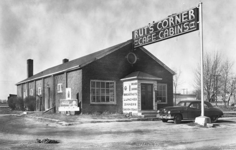
Next door is the old Annex Motel and Service Station, facing both old and new Route 66 alignments.
The Annex Motel and Cafe
The Centennial Yearbook (1953) of Litchfield tells us that "The Annex, formerly known as Rut's Corner, was purchased from William Bahr who had operated the business from 1947 to 1951. It was remodeled and opened in May, 1951, by Joseph Roseman and Estell R. Felts with Eugene A. Kozuk as manager. In April, 1952, Eugene A. Kozuk purchased the Felts interest and the Roseman-Kozuk partnership has continued since then."
It began as a ten unit motel expanded to 15 in 1953, and the restaurant sat 125 guests.
At 1200 Old Route 66 South, to your right. Below is a vintage postcard from the late 1950s that announces "THE ANNEX MOTEL - CAFE On the Airport Beacon Litchfield, Illinois Phone 127 Thirty-two Air-Conditioned Units. Free T.V. Some Units. On Rt. 66. Only 52 miles North of St. Louis and 45 miles South of Springfield, Illinois. Excellent Food at Annex Cafe 6 A.M. to 12 P.M. Automobile Servicing at Annex Standard Station. Reasonable Rates and Real Convenience. 'We only LOOK Expensive'
The Annex Motel and Cafe vintage postcard in Litchfield, Illinois

Its postcard also says that it had expanded further, to 32 air conditioned units and "Free TV some units".
Below is the current view, the buildings haven't changed but the low wall has gone. However, the foundation blocks of the lamp posts are still there (red arrows).
The Annex Motel and Cafe nowadays in Litchfield, Illinois

On its northern side was the Annex filling station that originally was a Phillips 66, then became a Texaco station ran by Willis Sturgeon and Thomas Telfer. Finally it became a Standard station. The cafe as you can see in the images below, was the original Ruts Corner Cafe:
Two views of the northern side of the complex: Cafe and gas station:

Continue south for 1.5 miles and you will reach the junction of both 1930-40 and 1904-77 alingments.
The highway from here to Mt. Olive is Listed in the National Register of Historic Places, read about it in our Springfield to Hamel IL alignment (1930-77 US66).
Your Route 66 Road Trip across Litchfield ends here. Head south along the 1930-77 alignment into neighboring Mr.Olive to continue your journey.
For those interested in nature, check the local park and prairie in our next section.

Signs where both alignments meet south Litchfield, Il. Click for street view

Route 66 prairie area north of Litchfield, Il. Click for street view
Outdoors, National and State Parks
Lake Lou Yaeger Park
The lake covers 1,400 acres and there is a 300-acre park on its shores with picnic and camping areas. Hike, fish or watch birds. Enjoy the outdoors here.
Just 4.8 mi. from town, see this map with directions.
Route 66 Prairie and Monarch butterflies
The Route 66 Prairie is a patch of the Illinois prairie that is the habitat of Monarch butterflies (Danaus plexippus). The prairie is located along the east Frontage road of I-55 between exits 52 and 60 and is part of the Route 66 Monarch Flyway. Visit the illinoismonarchproject.org website for more details. This is the map marking the spot with the sign (pictured above) at Litchfield's Route 66 prairie.

Sponsored Content
>> Book your Hotel in Chicago
Credits
Banner image: Hackberry General Store, Hackberry, Arizona by Perla Eichenblat
NPS National Register of Historic Places Belvidere
Litchfield Centennial (1953)
Jack DeVere Rittenhouse, (1946). A Guide Book to Highway 66