A Historic section of Route 66
Index to this page
- About Mt. Olive
- Weather
- Hotels in Mt. Olive
- Map of US 66 in Mt. Olive
- What to see and do in Mt. Olive
About Mt. Olive, Illinois
Facts, Trivia and useful information
Elevation: 685 ft (209 m). Population 1,867 (2020).
Time zone: Central (CST): UTC minus 6 hours. Summer (DST) CDT (UTC-5).
Mt. Olive is a city located in Macoupin County, south-central Illinois, on Route 66's 1930-1977 alignments
History of Mt. Olive
People have been living in what nowadays is the state of Illinois for over 11,000 years, since the last Ice Age ended. Later, when the first European explorers (French, coming from Canada) reached the area, they encountered the Illinoisian Indians. This took place in the 1600s.
The Illinoisians were displaced by the arrival of European settlers. The first one to homestead here was John Woods, from Virginia in 1817.
Macoupin County was established in 1829 and was named after Macoupin Creek (the word is a Miami-Illinois term for the American lotus: Nelumbo lutea).
John C. Nieman a Prussian, migrated to the U.S. in 1839 and settled in Macoupin County in 1841. Initially he worked as a farmhand for three years and saved $250 with which he bought his own farm.
He opened a store to make some more income in 1859, and the place became known as "Nieman's Settlement" and it became the seed of a small hamlet. He was its first postmaster. The town was platted in 1863 by George Farrar. The town incorporated in 1874.
The Name:Mt. Olive
Nieman named it "Oelberg" in German, or "Olive mountain", translated as Mount Olive, after the Biblical Mount of Olives in Jerusalem, Israel. The Lutheran congregation built the church in 1860 and dedicated it as Mt. Olive Zion Church.
When the railway reached the area they built Drummond Station, but later changed it to Mount Olive.
Coal was found on his property and he partnered in the Mount Olive Coal Co. in 1874 which by 1879 employed almost 150 miners. This impacted positively on the economy. His mine was located north of town where nowadays the 1930-40 and the 1940-1977 US 66 highways fork.

Hotels and Motels: Mt. Olive, Illinois
Find your lodging & accommodation close to Mt. Olive (sponsored content)
> > Book your hotel in neighboring Staunton
More Accommodation near Mt. Olive on Route 66
Below you will find a list of some of the towns along Route 66 east and west of this town; click on any of the links to find your accommodation in these towns (shown from east to west):
Along Route 66 in IL
- Hotels in Illinois
- Route 66 Starting point ▸ Chicago
- Lockport
- Willowbrook
- Bolingbrook
- Plainfield
- Romeoville
- Joliet
- Wilmington
- Dwight
- Pontiac
- Chenoa
- Normal
- Bloomington
- Atlanta
- Lincoln
- Springfield
- Raymond
- Litchfield
- Staunton
- Williamson
- Hamel
- Edwardsville
- Collinsville
- Troy
- Glen Carbon
- Pontoon Beach
- Granite City
- East St. Louis
West in Missouri
- Hotels in Missouri
- Florissant MO
- Bridgeton MO
- St. Louis MO
- Kirkwood MO
>> Check out the RV campground in Litchfield
The Weather in Mt. Olive
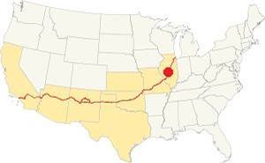
Location of Mt. Olive on U.S. Hwy. 66, Illinois
Seasons in Mt. Olive: summers are long, warm, and humid; winters are short, freezing, and windy. Temperatures may vary on average between 21°F (-6°C) to 86°F (30°C).
July has an average high of 86°F (30°C), and a low of 68°F (20°C). During winter the average low is 21°F (-6°C) in Jan. and the avg. high is a cool 35°F (1.7°C).
Mt. Olive's snowy period lasts for about 4.3 months, with an average snowfall of 22 inch (56 cm) yearly. Rainfall averages 37.5 inches per year (952 mm)
Tornado risk
Mt. Olive may be hit by some 7 tornados every year. an EF2 tornado ripped through Mount Olive in May 2013, hitting the business district
Tornado Risk: read all about Tornado Risk on Route 66.
Map of Route 66 in Mount Olive, IL
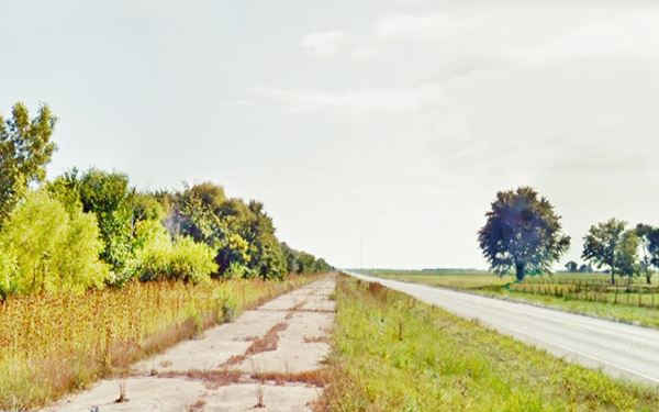
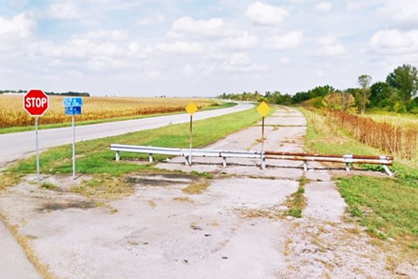
The highway from Litchfield to Mt. Olive was upgraded to a four-lane divided highway in the 1940s. It is Listed on the National Register of Historic Places. When it eaches the northern side of Mt. Olive, the original 1930 Route 66 forks off to the left, parallel to the tracks while the 1940 alignment curves around the town to bypass it as a beltline road.
1930-40 US66 in Mt. Olive
This is the map with directions across Mt. Olive.
Four Lane 1940-77 Route 66
The later highway bypassing the business district had the algnment shown in this map and its surviving NB lanes are marked with a green line in our custom map of Route 66. The older alignment is marked with a red line in the same map.
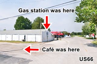
Both of them met on the south side of town where the Mill Cafe and gas station once stood.
Just 0.7 miles after the junction of alignments on the south side of Mt. Olive, both alignments split again: the original 1930-40 highway heads to the right towards Staunton while the later 1940-55 highway runs south towards Livingston along the eastern side of Williamson. The old set of lanes heading south are marked with a navy blue line in our custom map.
Route 66 across Illinois
In the state of Illinois, the Historic Route 66 has been designated as a National Scenic Byway and an All-American Road.
The Route 66 alignment in Mt. Olive
Visit our pages with old maps and plenty of information about US 66's alignments.
- Route 66 Hamel IL to St. Louis MO (Next)
- Springfield to Staunton IL (1926-30 US66 to the west of Mt. Olive)
- Springfield to Hamel IL (1930-77 US66 near Mt. Olive)
- Route 66 Pontiac to Springfield IL (Previous)
U.S. 66 Sights in Mt. Olive
Landmarks and Places to See in Town
Historic Context: Route 66 in 1946
In his book, published in 1946 (US Highway 66 Guidebook) Jack Rittenhouse tells us about his journey around the town using the 1940 Route 66 alignment:
At the fork of 1940s and 1930s Route 66 he mentions a "Gas station" followed one mile west by a picnic area and the access to the Miners cemetery and "Mother" Jones monument.
...garage;gas;small hotel). A small mining and farming town... Rittenhouse (1946)
On the south side of town he mentions the 1930s road as "a side road off (Right) at a tangent... at this intersection is the 66 Tourist Camp with cabins, gas, etc."
Fork of two alignments
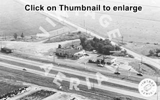
On the north side of Mt. Olive the 1930-40 US 66 forks off to the left and the 1940-77 curves to the right. This one had four lanes. At the fork, as yo can see in this 1956 aerial photo, was a gas station at the spot mentioned by Rittenhous where Max Mullins Salvage is now located.
The original highway winded its way through the town, bypassing its commercial district by taking two curves along its northern and western fringes. As it approaches West Main St. some original garages and cafes appear.
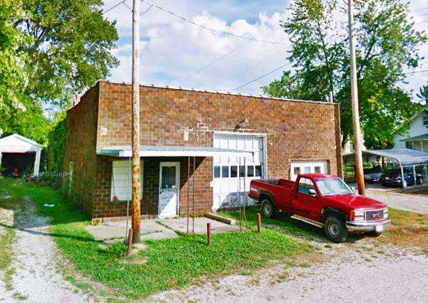
Old Garage
The red brick building to your left at 610 Old Rte. 66. It has a multi-pane service bay and a smaller second garage entrance to the right. The office is on the left side of the property with a flat canopy that seems to have replaced a gabled one.
Scherer's Café
Ahead, to your right, on the southwestern corner of W Main and Route 66 is a former cafe that opened in 1932.
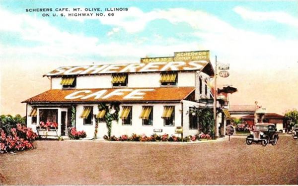
The postcard looks north along Route 66 towards W Main. You can see a gas station behind the café, on the corner. The old cafe building was torn down in the 1960s. The gas station was replaced (1940s?) by the current one.
It advertised as "Open Day & Night - "Good Coffee" U.S.- Highway 66 Phone 349 - MT.OLIVE, ILL."
Apparently a robbery was foiled by a waitress here in 1934, when she fired a gun into the face of a robber. This aerial photo taken in 1956, shows the current building and to the south, the original one, now gone.
On the next block is the best known Route 66 landmark and attraction in Mt. Olive, Soulsby's filling station.
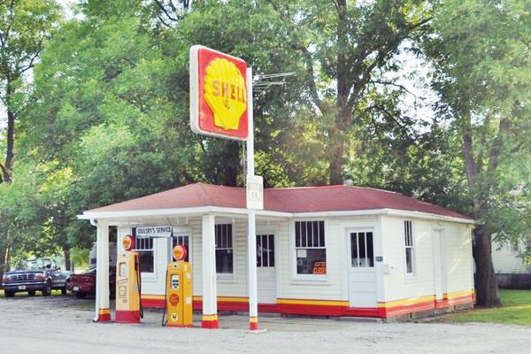
Soulsby’s Service Station
Listed on the National Register of Historic Places
One block south of Scherer's Café to your right, at 201 S. Route 66 on the SW corner with West 1st St.
History of the station
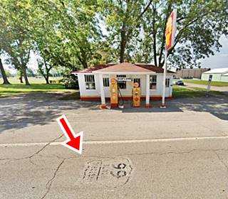
Henry Soulsby and his son Russell built the Shell gas station in 1926. At that time it was located on state higway 126 because U.S. 66 ran five miles west of Mt. Olive, aliong its 1926-30 alignment via Benld and Staunton.
Henry, like his father, an Irish immigrant had worked as a coal miner, but aftger an incapacitating accident he invested all his savings in his gas station. His bet paid off when the Mother Road was realigned in 1930 right in front of their business. They expanded their humble gas station at that time.
Russell ran the place with his sister Ola after the death of their father. They closed it in 1991.
The property has been rescued and preserved by a local non-profit organization.
Soulsby’s Service Station in Mt. Olive, Illinois
Below is a close up of the pumps:
Soulsby’s Service Station in Mt. Olive, Illinois
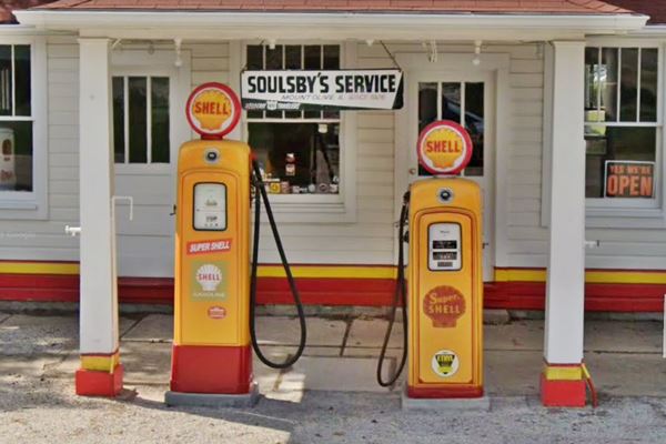
Both pumps seem to be Martin & Schwartz Model No. 80 gas pumps from the 1950s. One is taller than the other because of the height of the base. They both have the glass globe with the brand and the glass bezel that displayed the flowing gasoline.
Trivia: oil ramp
Don't miss the steel ramp to the south of the building, which was used for oil changes and repairs. A tree grows through it now! It is ancient.
Route 66 Shield
Wearing away due to the abrasion of the tires of the vehicles driving along Route 66, you can still make out a US 66 shield stencilled on the roadway in front of the old gas station.
>> Read more about the Shields painted on Route 66
Former Gas Station
On the NW corner of Route 66 and W 3rd. at 339 S Rte 66 it is an old station dating back to the 1960s. You can still see the concrete island but it has no gas pumps. The old building has been very modified building, and you can see its 3 door service garage.
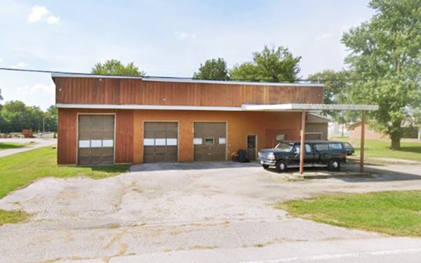
There are no more '66 sights south of this point along the 1930-40 US66, so take a small detour to visit the "Cemetery" mentioned by Rittenhouse and also downtown Mt. Olive.
Coal Town History
Mary Harris "Mother" Jones
Mary Harris Jones was an Irish-born American (1837-1930) who worked her way up from humble origins, working as dressmaker and a teacher to become an organized labor activist and representative.
Cofounder of the Industrial Workers of the World, she worked with the Knights of Labor and the United Mine Workers union.
She organized miners against exploitation and was feared by the Mine industry tycoons.
Mary Jones is buried in the Union Miners Cemetery in Mount Olive, next to the miners who died in the 1898 "Battle of Virden", who she called "her boys".
The monument that crowns her tomb was built with pink Minnesota granite and has two bronze miners flanking it. It was dedicated on October 11, 1936, now celebrated in Mt. Olive as "Mother Jones's Day."
Battle of Virden
This "battle" was actually a bloody shootout that took place in October 1898 between security guards and striking miners. It was an explosive mixture of labor union strife and racial violence (the strike breakers were African Americans). Four guards and seven miners died during the incident that took place at the Chicago-Virden Coal Co. (Virden is on the 1926-30 US 66 alignment to the NW of Mt. Olive).
"Mother" Jones Monument and Union Miners Cemetery
700 North Lake Street. See this Map with directions from Soulsby Station.
Listed on the National Register of Historic Places
As the miners killed during the Virden Mine Riot were denied burial in cemeteries of this part of Illinois, the local miner union bought a plot of land to bury them there (1899). The cemetery became the Union Miner's Cemetery and expanded. Mary Harris Jones requested to be buried here.
Rittenhouse described the cemetery as follows:
Intersection with a graveled road Left, leading to MOUNT OLIVE. A few roadside tables at this intersections. A few hundred yards off (Left) on this graveled road is the MOUNT OLIVE UNION MINERS CEMETERY, where the members of the coal unions bury their dead. Here is a monument over the grave of "Mother" Jones a famous woman leader of the miners who died in 1930 at the age of 100. Rittenhouse (1946)
Detour into downtown Mt. Olive
Head back to Main Street and turn east into the town, it has plenty of red-brick buildings from the early 1900s in good shape. For those interested in local history, you can visit the museum:
Friends of Mother Jones Museum
215 A East Main Street. Dedicated to transmit the story and efforts of "Mother" Jones; more information at their official website.
Continue your sightseeing trip
Drive west along Main to meet the 1940-77 Route 66, the "four lane 66" that is one mile west of Scherer's Café. At the crossroads is a Motel from the 1960s and an old cafe to your right, on the NE corner.
Old Motel, Big Boy, and Route 138 Cafe
The cafe dates back to the 1950s because it appears in the 1956 aerial photograph of this crossroads. Behind it, on its eastern side was the old "Sunset Drive-In" that opened in 1951. It was owned by L. Odorizzi. It closed in 1977. The concrete foundations of the screen can be seen behind the cafe building.
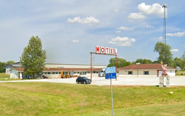
The thumnail aerial photo above, taken in 1981 shows the L-shaped "Budget 10 motel" now closed, and a small Texaco with its sign in the central courtyard. To the right is the Cafe, unchanged. Notice the four-lane Route 66 to the left. Below is the current view of the property. The vacant motel is in the background. The Texaco station is gone and its sign has been modifed to read "MOTEL", and surprisingly, there is a Frisch's Big Boy restaurant statue on top of a concrete block pedestal.
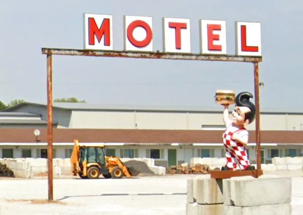
Another view, now showing the motel and cafe buildings:
Vintage Motel and Cafe in Mt. Olive, Illinois
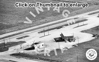
1981 Thumbnail of Crossroads Restaurant and Amoco. Mt. Olive, Il. Click image for full sized picture
Crossroads Restaurant and Amoco
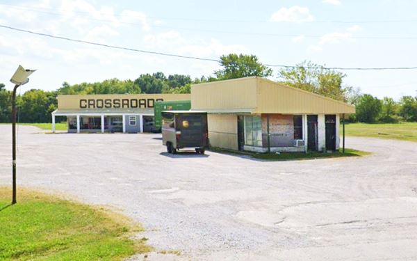
Opposite the motel complex, on the SW corner of the crossroads is the Crossroads Restaurant and a former Amoco gas station. You can see both buildings in the image below, an aerial photograph from 1989; click on the thumbnail image to enlarge it.
The old Conoco's corner office can be seen on the NE tip of the building and the entrance to the restrooms, facing State Hwy. 138. The service bays faced Route 66. It does not appear in the 1956 aerial photo of the area, so it was surely built in the early 1960s.
Mill Cafe and Gas Station site
Drive south along the 1940-77 Route 66 and you can see, to your left, some segments of the former eastbound lanes of the 4-lane "superhighway". Two miles south of the crossroads the 1930-40 Route 66 alignment coming from Soulsby's Shell Station meets the four-lane '66. Below is a view of the junction. The arrows mark the Historic four-lane Route 66 alignment (1940-77) and the 1930-1940 alignment forking off to the right into Mt Olive. The original northbound lanes are blocked off and can't be driven. The red circle marks the two official road signs of both alignments. Look for these brown signs on your journey, you won't get lost.
Fork of both US 66 alignments on the south side of Mt. Olive, Illinois
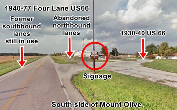
The Mill stood where the buildings in the image (behind the red circle) are now located. This is where Rittenhouse mentioned a "tourist camp" with cabins and gas, it has now vanished.
The thumbnail image is an aerial photograph taken in 1967 (click on it to enlarge it). It looks towards the NE, you can see the four-lane alignment in the foreground, and the 1930-40 US66 forking off behind the cafe (left) and Shell station (right). The buildings were torn down. Nothing remains. Its matchbooks promoted it as "The Mills Cafe Dine & Dance - Beer Wine Liquor - MT. OLIVE JCT. - The Best Eats on Route 66." This matchbook calls it Mills with an "S", however a 1966 court opinion states that "The Mill Cafe" was owned in 1965 by Joseph Makula and John J. (Chippy) Ciprianom. Chippy's wife Mary worked at the family restaurant
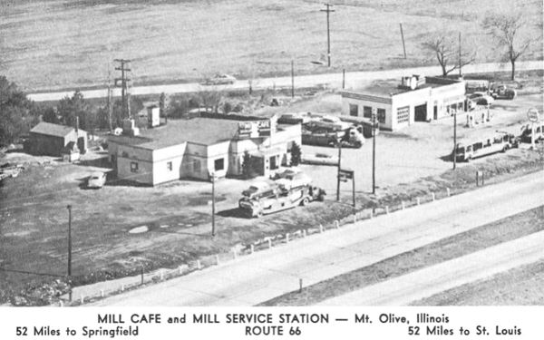
The image above looks to the SE, old Route 66 runs behind the premises, the 1940-77 highway runs from Mt. Olive (left) to Staunton - Livingston (right).
The highway continues straight southwards, with some sections of the old 4-lane eastbound lanes cracked and overgrown with weeds to your left. After 0.7 miles there is a fork, the two alignments of Route 66 split and your Road Trip through Mount Olive ends here. You have two options:
- Continue your Route 66 Road Trip westwards along the 1930-40 US66 towards Staunton
- Head south along the 1940-77 course of Route 66 into Livingston.
Both meet further south at Worden's Wye, just east of Hamel.

Sponsored Content
>> Book your Hotel in Chicago

Credits
Banner image: Hackberry General Store, Hackberry, Arizona by Perla Eichenblat


