"Proud Past, Promising Future"
Index to this page
About Eureka Missouri
Facts, Trivia and useful information
Elevation: 456 ft (139 m). Population 13,533 (2024).
Time zone: Central (CST): UTC minus 6 hours. Summer (DST) CDT (UTC-5).
Eureka is a city located on the western edge of St. Louis County, on the 1932-1977 alignment of Route 66 in the central-eastern Missouri.
History of Eureka
Eastern Missouri has been inhabited since the end of the last Ice Age some ten thousand years ago. More recently, its Native American inhabitants were members of an Algonquin nation known who called themselves "Illiniwek" which meant "men" in their language. They were hunter-gatherers who also grew crops of squash, corn and beans
Explorers from the French Canadian colony reached the area in 1683 and claimed it for France, naming it after their king Louis XIV (Louisiana). They called the natives using a deformed form of their name: "Illinois". Later during the Seven Year War, France lost the territory to Spain, and the Spanish explored the area and set up some settlements.
What would become the city St. Louis was settled in 1764 by Laclede and Chouteau, followed by Carondelet in 1767, Florissiant (then St. Ferdinand) in 1785. Then, in 1800 Napoleon recovered the territory from Spain but needing cash for his war against Britain, sold it in 1803 to the U.S. In the new territory, St.Louis incorporated as a municipality in 1809. The Territory of Missouri was established in 1812, and it achieved statehood in 1821. St. Louis became a city the following year.
During the 1830s, the Illinois people were forcibly relocated together with all the other Natives that had in the past lived east of the Mississippi, to reservations in what is now Oklahoma. This opened the way to white settlers in the region.
A Missouri Pacific Railroad camp set up there in 1853 was, of course named Eureka and in 1858 the town was platted. The post office opened in 1860 and was named Eureka.
The Name: Eureka
While surveying the terrain for the Missouri Pacific Railroad, an engineer found the narrow valley next to the Meramec River and was delighted because it avoided a lot of earth moving to grade the tracks. He is said to have cried out "Eureka!", which comes from a story about Archiemedes who while bathing in the Greek colony of Syracuse in Sicily found the way to determine if the king's crown was made of pure gold or had been adulterated with cheaper silver. He sprang out of his bath and ran naked down the street crying out "Eureka!" (from "heureka" = "I've found it). He did, he'd discovered the density of materials and the incompresibility of water.
The town was a small farming community next to the Meramec River and when a new paved alignment for Route 66 was built through it in 1932, it provided some services to travelers using it. Eureka incorporated as a city in 1954.

Accommodation: Where to Lodge in Eureka, Missouri
> > Book your accommodation in town: Eureka
More Lodging near Eureka along Route 66
There are several hotels in the area close to this town. Alternatively you can also find your accommodation along Route 66 in the neighboring towns and cities in Missouri. We list them below (from east to west):
On Route 66's Main alignment in MO
Eastwards
Westwards
- Hotels in Kansas
- Baxter Springs KS
- Galena KS
- Riverton KS
- Hotels in Oklahoma
- Miami OK
>> Check out the nearby RV campground in neighboring Pacific
Weather in Eureka
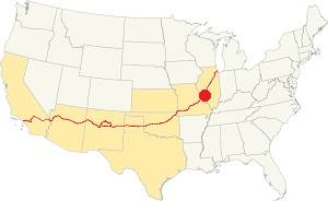
Location of Eureka on U.S. Hwy. 66
Eureka has four well marked seasons. It is located in the area where humid continental climate shifts towards a humid subtropical climate, so summers are hot and humid while winters are cold. It gets cold Arctic air and hot damp tropical air from the Gulf of Mexico. Spring is wet and may have extreme weather (tornados, thunderstorms and even winter storms). Fall is sunny and less humid, with mild weather.
The average high in winter (Jan) is a cool 39.9°F (4.4°C) while the average low is a chilly 23.7°F (-4.6°C). The summer (Jul) average high is 89.1°F (31.7°C) and the average low is 71°F (21.7°C). Rain is on average 41 in. (1.041 mm) with the rainiest months being May through July with over 4.1 in monthly (104 mm). Snow falls between Nov. and Apr., with a total snowfall of 17.8 in. (45 cm). Relative humidity averages 69.7% and is fairly stable year round.
Tornado risk
Eureka is located in Missouri's "Tornado Alley" and St. Louis County is struck by some 7 tornados every year. Tornado Risk: read more about Tornado Risk along Route66.
Map of Route 66 in Eureka
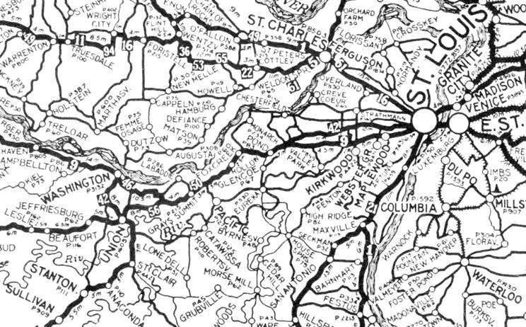
1924 Auto Trails Map. Source.
Click image to enlarge
The first alignment (1926 to 1932) of Route 66 went along the "State Road to Jefferson City" and didn't go through Pacific.
The thumbnail map (click on it to enlarge) shows the "Auto Trails" in this region in 1924. These trails were roads that cars could drive along relatively safely in the days when mud, pot holes and river fords complicated driving. See Pacific on a secondary highway in the middle of the map.
The map below, published in 1931, shows Pacific when Route 66 went through Grays Summit.
Map 1931 showing US66 into St. Louis
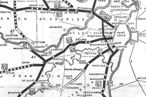

1933 Map of Route 66 from Villa Ridge to St. Louis. click for full size map
Death Lane
The highway was realigned through Eureka into St. Louis in 1932 (see image, click for large size map) but by the early 1940s Route 66 was congested and the heavy traffic made it unsafe.
Rittenhouse mentions in 1946: "From here (Gray Summit) into St. Louis, US 66 has three or more lanes." The third lane although designated in one direction, was known as the "death lane" due to the head-on crashes caused by those who didn't follow the rules. It was upgraded to a new four-lane divided dual carriageway highway which replaced the old US 66 in the mid 1950s.
Map of US66 into Eureka
Route 66 has a small segment that can be driven on the eastern side of the Meramec River. Route 66 west of this point into Eureka was torn up when the freeway was built over the old alignment. It resurfaces on the north side of the freeway at Exit 264 as E Fifth St. and runs west all the way to the next exit (261) as shown in this map Eureka-Allenton, where it headed to what is now the south side of I-44 in Allenton, it is now cut off by the freeway, but resurfaces in Allenton.
The Route 66 alignment in Eureka
Visit our pages with old maps and plenty of information about US 66's alignments.
- Gray Summit to Rolla (next)
- Route 66 St. Louis to Gray Summit (In Eureka)
- Route 66 Hamel IL to St. Louis MO (previous)
Route 66 Sights in Eureka
Landmarks and Places to See
Eureka and its Route 66 attractions
The WPA travel guide "Missouri, a guide to the "Show Me" state" published in 1941 tells the story about the origin of its odd name, and of the nearby "Camp Wyman", 3 mi. away for underprivileged children and mothers, established in 1897.
Wyman Center
The St. Louis Children's Industrial Farm, was established in 1898 to give children from the low class slums of St. Louis tenement a chance to experience rural life. The Farm became Camp Wyman (now part of Wyman Center) one the oldest camps in the US
Jack DeVere Rittenhouse in his "A Guide Book to Highway 66" published in 1946, also mentioned it; after Sylvan Beach, the only place he mentions east of Eureka and that from there, westwards into Eureka the higway "... is a pretty, semi-rural route, well paved".
EUREKA. Pop. 663; alt. 465'; gas. A small community established before the Civil War Rittenhouse (1946)
Rittenhouse does not mention cabins, hotels, motels, or other local attractions.
Route 66 on the Meramec River
You can only reach Eureka by using the Interstate. It bypasses the razed town of Times Beach (Route 66 State Park) and then overlaps on the original US66 roadbed, after crossing the two railroads that meet in Pacific ( former Missouri Pacific and the Missouri San Francisco lines), leave I-44 at Exit 264 and reach MO-109. The original alingment has been destroyed by the interchange. East of it, along E 5th St., the North Service Road, next to Byerly RV was a now gone Route 66 Cafe and Cabins site:
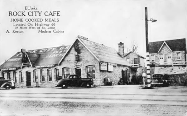
Rock City Café (Gone)
The place was "19 miles west of St. Louis" and offered steam heated "modern cabins", hot and cold showers and home cooked meals. It was built by A "Deek" Keeton between the two railroad lines. Next to it, on its eastern flank was Ed LaMar's Ozark Cafe, tavern and filling station. As both businesses had similar stone buildings, the complex became known as "Rock City". By the mid 1950s when the four lane alignment was built, it had gone out of business: this 1958 aerial photo shows the spot, linked to the highway (it wasn't at that time a limited access freeway) but vacant, the buildings gone.
Turn left and follow E 5th St. there were several buildings on the original alignment at the intersection with Central Ave. The buildings along the old Route 66 on the south side of the original roadway were razed when first four-lane alignment was built in the 1950s. Among them was the "White Squirrel Tavern", opposite Gerwe's Cafe.
This highway was later replaced by a much wider roadbed for I-44 (1968)- Only some buildings survived on the north side of the highway and can be seen in the following "Then & now" sequence:
Vintage 1956 photo of Central Ave. and Route 66 overpass in Eureka, Missouri
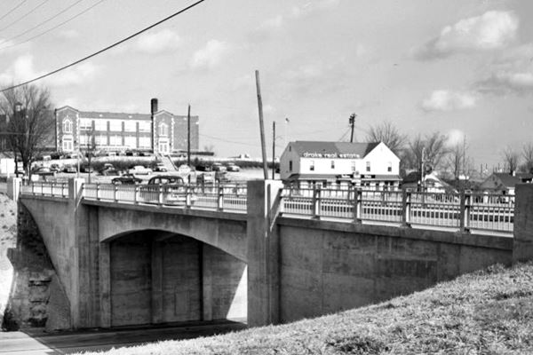
1956 photo above and the current view below are very similar:
Central Ave. and Route 66 overpass, nowadays in Eureka, Missouri
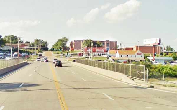
The two-story red-brick Tudor Castle-style building in the central part of the pictures is still there, it is the Rockwood School District Admin Annex building, let's look at the other surviving landmarks:
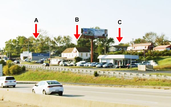
Gulf Station
On the NW corner of the intersection, at 1 W 5th St., was until recently the local branch of Sullivan Bank. It used to be a Gulf Service Station, it is marked with an "A" in the "Then and Now" Sequence below.
Drake Real Estate
On the NE corner, is Drake's real estate office marked with "B" in the images. It is the two story gabled roof building on the right side of the overpass. It used to be an ice cream parlor. It faced the original Route 66 alignment and also the exit ramp of the 4-lane 66 of the 1950s. This ramp was later eliminated.
Sinclair Station
The building (see "C" in the images below) has survived, but was modified. It was a gable roof Sinclair filling station.
Route 66 and Central Ave. 1956
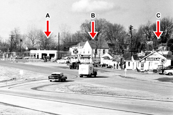
Route 66 and Central Ave. Nowadays
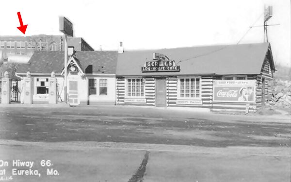
Gerwe's Log House Cafe (Gone)
The log house cafe and gas station is pictured below, the red arrow marks the Rockwood School District Annex Bldg., this is the street view of the spot. The place was torn down long ago.
This Aerial photo taken in 1958 shows the overpass of Central Ave. and Route 66.
Phillips 1960s Gull-wing gas Station
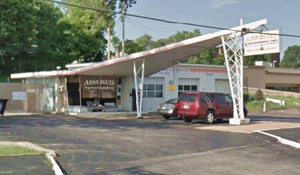
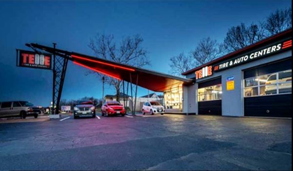
Just ahead, on the service road, at 19 W 5th St, past the overpass is an old gull-wing station. Phillips Petroleum Co. standardized their gas stations across the country in the 1960s, adopting a modern look the "gull-wing" (or bat-wing) canopy held up at the narrow tip by a pole designed to look like an oil derrick. Atop the pole was their revolving sign. This is one of those stations.
Now it is Telle Tire (a tire shop), but it has kept the main office with its canted plate glass windows, the garage, and canopy intact.
1960s Phillips gull wing gas station, Eureka, Route 66, Missouri
1960s Phillips gull wing gas station, Eureka, Route 66, Missouri
>> Learn more about the Phillips66 Gull wing stations on Route 66.
Former Phil's Bar-B-Cue Quonset hut
On the next block, to your right is another building, a former Restaurant known as Phil's Bar-B-Cue, at 114 West 5th St. The building with a semi-cylindrical shape like a large sized quonset hut, was a restaurant which has closed recently. It had been open as Phil's since 1985 when. It was described by Maura Johnson and John F. Bradbury in the 1993 "Architectural ⁄ Historical Inventory Survey - Route 66 in Missouri" and identified as a classic diner.
Quonset huts were prefabricted semicircular structures with corrugated sheet steel walls and roof; they were first built by the US Navy in Quonset Rhode Island in 1941 during WWII. Below is a view from 1956 (red arrow marks the hut), and nowadays.

Quonset hut in 1956 (arrow). Source
Drive west, towards Allenton, nothing remains on the original alignment, but you can spot the remains of an old gas station on the south side of the freeway.
Hubert's Site
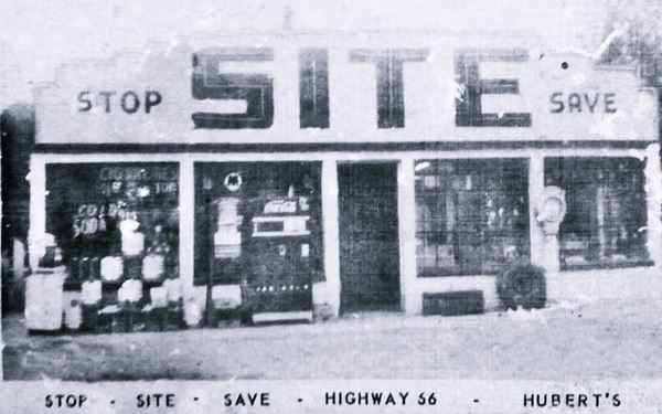
With the words "Stop - Save" on its facade, Hubert's was a gas station on the south side of the four-lane Route 66, between its eastbound lanes and the railroad. When the freeway was built, it was torn down. Its concrete foundations can still be seen in the bushes on the shoulder of the freeway opposite 1415 W 5th Street (as you can see in the street view). This is an aerial photo taken in 1958, and below is a vintage picture of the spot:
This leg of your Route 66 road trip ends here, you can drive west by Allenton to continue your itinerary.

Other Eureka sights and attractions
There are some local attractions which are not related to Route 66, but can be of interest to some travelers:
Black Madonna Shrine
100 St. Joseph Hill Road, 7.6 mi. to the south, Map with Directions. Open Year Round, admission is free (full details at their website). The Black Madonna (Virgin Mary Shrine and Grotto) was built in 1938 by a Polish priest of the Franciscan order, Brother Bronislaus Luszcz as a replica of the original shrine in Poland. It is dedicated to the "Black Madonna of Czestochowa".
Hidden Valley Ski Resort
17409 Hidden Vallley Dr. 3.2 mi. north, Map with Directions. Yes! a ski resort in the hills just next to Eureka. Check out their website.
Endangered Wolf Center
6750 Tyson Valley Rd. Exit 269, 6.9 mi. to the N.E. Map with Directions. For over 40 years conducting a captive breeding program to preserve and protect Mexican wolves, red wolves and other wild canid species and reintroducing them into the wild. More information at endangeredwolfcenter.org.
Six Flags Amusement Park
4900 Six Flags Road, 3.7 mi. to the N.W. Map with Directions.This is the St. Louis Six Flags, open April to Oct., check their website.
Some sponsored content
> > Book your Hotel in Lebanon

Credits
Banner image: Hackberry General Store, Hackberry, Arizona by Perla Eichenblat
Architectural - Historic Survey of Route 66 in Missouri and Detailed Survey, Maura Johnson. 1993
Jack DeVere Rittenhouse, (1946). A Guide Book to Highway 66


