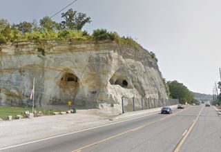
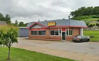
Route 66 by the sandstone bluffs
Index to this page
About Pacific Missouri
Facts, Trivia and useful information
Elevation: 466 ft (142 m). Population 7,438 (2025).
Time zone: Central (CST): UTC minus 6 hours. Summer (DST) CDT (UTC-5).
Pacific is a town located on the northwestern tip of Franklin County, on the 1932-1977 alignment of Route 66 in central-eastern Missouri.
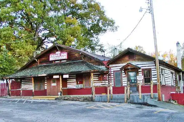
Historic Red Cedar Inn
History of Pacific
For a general history of Franklin County area visit our St. Clair History page.
First settled in 1820. A covered bridge was built over the Meramec River in 1838, south of where the present town of Pacific is located; it was destroyed by a flood in 1895.
Pacific was platted in 1852 and named "Franklin" after the county, but there already was a town with that name in Howard County, so it changed to Pacific when it incorporated in 1859. The first post office opened in 1854. In 1864, during the Civil War, Confederate troops led by Gen. Price fought here and lost against Union forces and had to retreat.
The Name: Pacific
After the Missouri-Pacific Railroad, or MoPac, which was one of the first railroads in the United States west of the Mississippi River. It laid its first tracks in 1851 and reached Kansas City in 1865. Its original goal was to reach the Pacific Ocean, hence its name.
The town thrived on silica mining, and it was also a main stop on both the "Frisco" railroad (towards Springfield) and the MoPac.
The new alignment for Route 66 was built through Pacific, and in 1933, the paved highway linked it with St. Louis in the East and Villa Ridge in the West. Route 50 was realigned on the original 1926-32 alignment of Route 66. And many cafes, motels, and gas stations opened in town to cater to the travelers.

Your Hotel in Pacific, Missouri
There are plenty of accommodation options and motels in Pacific.
> > Book your Hotel in Pacific
More Lodging near Pacific along Route 66
There are several hotels in the area close to this town. Alternatively, you can also find your accommodation along Route 66 in the neighboring towns and cities in Missouri. We list them below (from east to west):
On Route 66's Main alignment in MO
Eastwards
Westwards
- Hotels in Kansas
- Baxter Springs KS
- Galena KS
- Riverton KS
- Hotels in Oklahoma
- Miami OK
>> Check out the RV campground in Pacific
Weather in Pacific

Location of Pacific on U.S. Hwy. 66
Pacific has well-defined seasons, because it combines wet continental and humid subtropical climates. The winter (Jan), the average high is around 39°F (4°C) and the average low is a freezing 21.8°F (-5.7°C). The summer (Jul) average high is 88°F (31°C) with an average low of 68°F (20°C). Rainfall averages 43 in. (1.092 mm) yearly, concentrated over 90 days each year. There are about 205 sunny days per year. Snowfall is around 12.8 in. (32.5 cm) falling from Dec. to Mar.
Tornado risk
Pacific is located in Missouri's "Tornado Alley" and Franklin County is struck by some 7 tornadoes every year. Tornado Risk: read more about Tornado Risk along Route66.
Map of Route 66 in Pacific
>> Custom map with the alignments of US66 in Pacific.
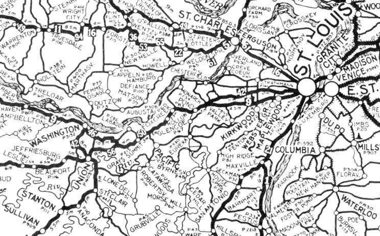
1924 Auto Trails Map. Source.
Click image to enlarge
The first alignment (1926 to 1932) of Route 66 went along the "State Road to Jefferson City" and didn't go through Pacific. The thumbnail map (click on it to enlarge) shows the "Auto Trails" in this region in 1924. These trails were roads that cars could drive along relatively safely in the days when mud, pot holes, and river fords complicated driving. See Pacific on a secondary highway in the middle of the map.
The map below, published in 1931, one year before US 66's realignment through Pacific (it ran through Grays Summit until 1932).
Map from 1931 with U.S. 66 into St. Louis
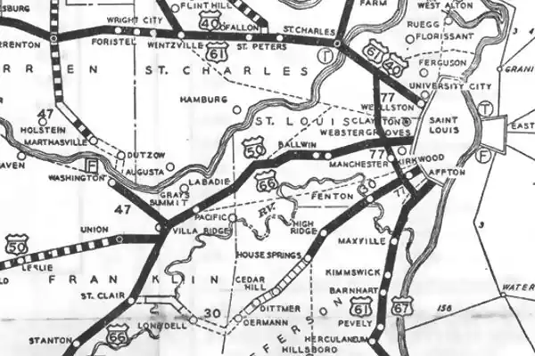

1933 Map of Route 66 from Villa Ridge to St. Louis. click image to enlarge map
The highway was realigned through Pacific, Eureka, into St. Louis in 1932 (see image, click it to enlarg the map), but by the early 1940s the highway was congested and the heavy traffic made it unsafe, so it was widened during WWII. Rittenhouse mentions it in 1946: "From here (Gray Summit) into St. Louis, US 66 has three or more lanes." It was upgraded to a new four-lane divided dual carriageway highway which replaced the old US 66 in the mid 1950s.
The Route 66 alignment in Pacific
Visit our pages with old maps and plenty of information about US 66's alignments, described in detail.
- Gray Summit to Rolla (next)
- Route 66 St. Louis to Gray Summit (In Pacific)
- Route 66 Hamel IL to St. Louis MO (previous)
Route 66 Sights in Pacific
Landmarks, Stops, and Places to See
Historic context, the classic Route 66 in Pacific
The WPA travel guide "Missouri, a guide to the "Show Me" state" published in 1941 mentions the origin of its name, and the importance of silica mining to the
local economy.
Jack DeVere Rittenhouse in his "A Guide Book to Highway 66" published in 1946 also mentioned it:
Pacific... gas; garage; stores.) At the eastern edge of town is the Pioneer Silica Products Co. mine, typical of the mines here which produce silica for glassware Rittenhouse (1946)
He also wrote that one mile east of Pacific, Rittenhouse mentions "Historical Marker beside the highway" marking the point where the Confederate Army reached in 1864, at the foot of "a very high bluff with a SCENIC OVERLOOK at its summit... parking space at the foot of bluff." The marker has been relocated to Blackburn Park.
Your Route 66 Road Trip through Pacific
Begin your tour on the eastern side of Pacific along Old Route 66, which is now BL-44. The first landmark is 1.3 miles west of I-44's Exit 261 in Allenton. To your right, on the north side of the highway, a classic 1940s motel:
Al-Pac Motel
At 18652 Historic Rte 66, Pacific. Location map.
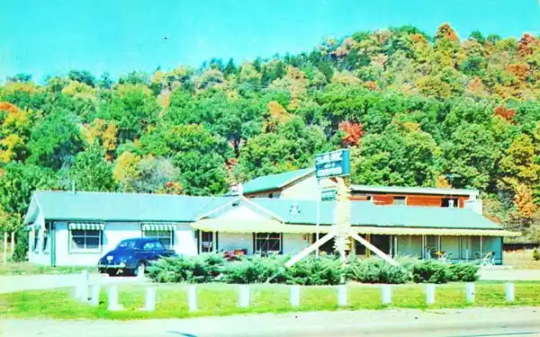
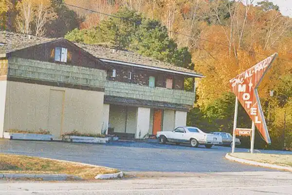
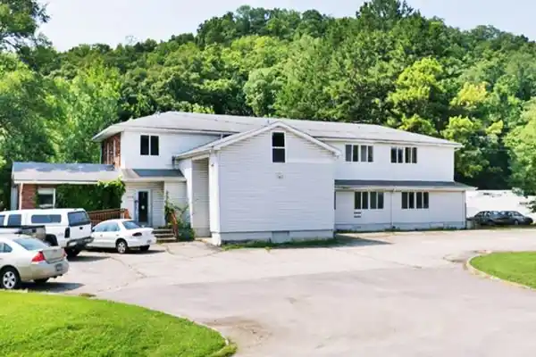
Dating back to 1942, the motel's main building has changed: the gable roof section in the front has gone, but the two-story wing in the back has survived. It advertised itself as "The Alpac home of Good food on Highway 66 3 miles east of Pacific, MO - Jean and Fred Miller". In the 1950s, it acquired an attractive arrow-shaped
sign with white letters on a red background, but now it's gone. Below are some images from the 1940s, 70s and nowadays; the same forward facing cross gable two-story structure appears in all three images.
Al-Pac Motel in the 1940s
Former Gas Station
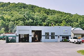
Just 0.15 mi. west, to your right, is a concrete block building with two service bays on the north side of the road. It looks like a former garage and service station (see image). It can be seen in this 1958 aerial photo. Also, notice in the aerial picture, the arc-shaped set of cabins to the east of the gas station, now gone, has been replaced by the yard of a contracting company.
Campbell's Service Route 66 Museum
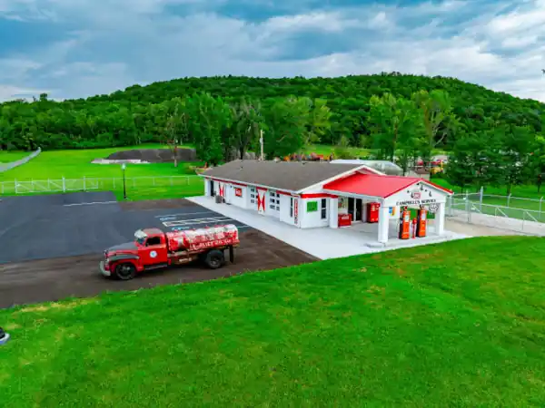
Just 1,000 ft (300 m) west is a new attraction, it is a reimagined service station from the 1950s, built on what was formerly a Baptist Church. It houses a collection of Route 66 memorabilia owned by Larry West that were originally owned by Duane Campbell. (18625 Historic Route 66). Visits are by appointment only. Visit their website.
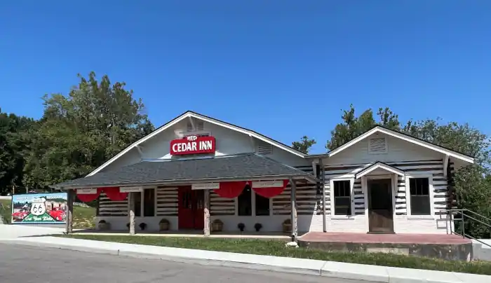
Head west; the highway will curve, becoming E Osage St. as it meets the Meramec River. Here, to your right, in Eastern Pacific, on the north side of the road, is the Historic Red Cedar.
Red Cedar Inn
The site hosts the original inn repurposed as a museum and visitor center, a Route 66 shield, and a mural.
Centennial Route 66 Shield

Route 66 100th anniversary shield, Pacific
This is a great spot for a photograph, the 12-foot-tall shield is a new landmark that was erected to celebrate the 100th anniversary of The Mother Road next year. Learn more about the Route 66 Centennial (1926-2026).
Red Cedar Inn and Visitor Center
Listed in the National Register of Historic Places
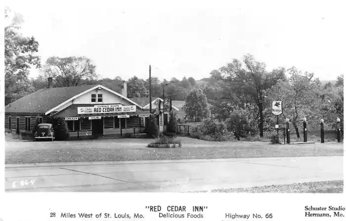
At 1047 East Osage St. It was owned and operated by two brothers, James and "Bill" Smith. They had been bootleggers, selling their own moonshine liquor, and they
opened the Red Cedar Inn just when Prohibition ended in 1933. It served plenty of booze.
They added a restaurant in 1935. And also sold Mobil Gas.
It is Pictured above at the top of this page, and below are some more views of it.
Dutch Wehrle from Eureka built it with peeled cedar posts from the Smith's farm in Villa Ridge, with wide white chinking between them the idea was to create an
atmosphere of Missouri pioneer days. The bricks were made in Pacific.
James Smith Jr. and his wife, and then his son (grandson of the original owner) ran it until 1972, when it closed until 1987, but closed again in 2005, permanently. The city purchased it in 2022 and it reopened in 2024 as a museum and visitor center.
Jensen Point
Ahead, right, 360 feet away from the inn is the parking lot for those who want to walk up to Jensen Point Overlook on the sandstone bluff.
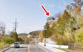
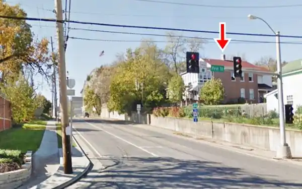
This Scenic Overlook is a small limestone building with a hipped pyramidal roof. It sits on the top of a bluff overlooking Route 66 and Pacific (red arrow in the image). It can be reached by two paths coming from the paved parking lot next to the highway at the base of the hill. Stone steps lead to it. It closed in 1991 and was acquired by the city of Pacific in 2014, restored and reopened to the public in 2016. Built in 1939 by the Civilian Conservation Corps it was part of the Henry Shaw Gardenway, a beautification project of the National Park Service and the Missouri State Highway Commission; the only remnants of the Gardenway are this overlook, and the Allenton Bus Shelter, now in Gray Summit. This overlook was dedicated to Lars Peter Jenen (1867-1941), the first president of the Henry Shaw Gardenway Association and manager of the Shaw Arboretum.
Sandstone Bluffs in Pacific Missouri
Ahead, the road runs next to the bluffs and the river with a winding course, passes the mine and mineral silos of the "US Silica Co"
Sand Mountain is the most prominent feature of the local topography. The front of the cliff was sheared away by the Missouri Highway Department in the early 1920s and widened in 1932 to make space for Route 66.
They consist of St. Peter sandstone capped by Joachim dolomite. This is ancient sand (455 to 459 million years old) formed in the shallow water of a Paleozoic sea. The cliffs have been tunnelled with mines (unsafe! Don't enter them) to obtain sand (silica) used for manufacturing glass. Mining continues on the northeast side of town (U.S. Silica Company started mining here in 1924) in an open-pit mine, which yields 98.8% whole grain silica sand used in flat glass, glass containers, and
in many other industrial uses.
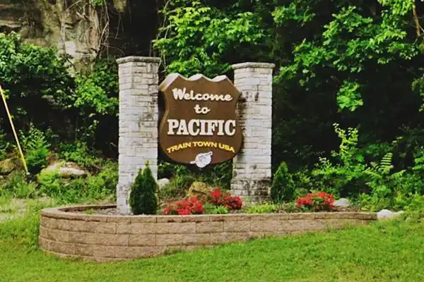
Ahead is the "Welcome" sign to Pacific, "Train Town USA".
Beacon Court Motel
Route 66 Roadside Attraction
Head west past the mine. To your right is a classic motel site. It opened in 1946 as "Beacon Court" and closed in 1980. It was demolished, and only the sign survives. Now it is a car wash. It boasted "16 Modern, Inviting, Tastefully Decorated Cottages... Automatic Hot Water Heat, FREE Television... Restaurant next Door."
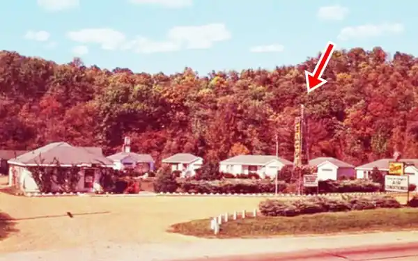
Beacon Motel Neon Sign
The eye-catching neon sign (red arrow in postcard above) was built on an old windmill tower obtained from a farm. It had a flashing light ("beacon") on its top and a vertical layout with yellow letters on a blue background with its name. It was restored in 2018 and now stands at the car wash & pet wash.
Lit Beacon Neon sign, Route 66. Source
1940s Gas Station
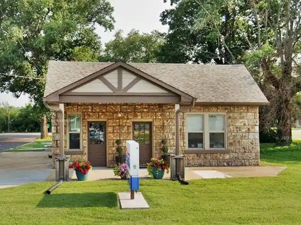
The town starts here, head straight for 0.3 mi., and to your left is an Old service station on the SW corner of Neosho St. and E. Osage St. This is a stone building with a gabled roof and a canopy projecting over the area where the pumps once stood.
There is a single service bay in the box-shaped addition behind it, facing Neosho St. It seems to date back to the 1940s and was listed by the 1993 Missouri Route 66 Survey. Now it is an insurance broker's office.
Former DJ's Cafe - Monroe Diner
Route 66 Roadside Attraction
Continue west for 0.1 mi. and on your right is a Classic Diner at 409 E Osage. It has had many names over the years. It began after World War II as a false-front permastone facing surplus Quonset hut housing the Miller's (Betty and Jerry) laundromat store.
Quonset huts were prefabricated semicircular structures with corrugated sheet steel walls and roof; they were first built by the US Navy in Quonset, Rhode Island, in 1941 during WWII.
In the early 1960s it was Norbert Funke's photography studio. Then it was DJ's Cafe, named after its owners Delisa and Joyce (1993), which served as Monroe Diner and after 2013, as Dawn and Joseph Vinson's Down South Café now it is Chef Amelia's Graze Catering.

Graze catering, US66 Pacific MO. Source
Another Gas station
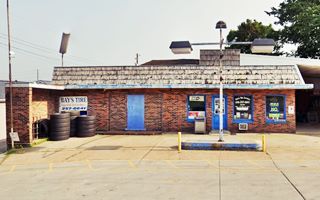
Don't miss the gas station to your left at 116 E Osage, now it is Bay's Tire Service. It has a red-brick facade and a walled-in service bay to the left. The old gas pump island is there, without its pumps.
Bluffs and Route 66 in Western Pacific
Continue your trip, and after 0.4 mi. the bluffs approach the road to your right. The original highway from Pacific to Gray Summit crossed the railroad in Pacific and ran south of it, with a westerly course, crossing Brush Creek (W Congress St.) When the new Route 66 alignment was defined, it was built in the narrow strip between the existing homes and the bluffs. The images show the same spot, and the same house (red arrow) over the years, with Route 66 running in front of it, at the foot of the cliff.
Before Route 66 was built here, it was a short gravel-surfaced street.
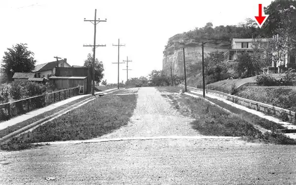
The paved Route 66 in the mid 1930s
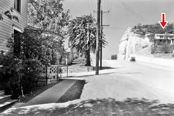
Historic Route 66 nowadays, same spot a shown in the previous pictures
Blackburn Park
Historic Marker
Just ahead, the highway runs along the foot of the bluff, and you can stop and visit the park right on the top of the bluff: take a right on N 2nd St. and drive behind it (Map with directions). Free admission and parking. Open year-round. It has a Civil War Replica Cannon and a good view of the town from the top of the bluff, as well as "The Battle of Pacific - Missouri's Civil War" marker (mentioned by Rittenhouse) next to the cannon.
Return to Route 66, at the foot of the bluff is a small park, Adam's Garden. Below is the Park with the cave in the bluff face, seen in the 1950s and now.

Bluff at Blackburn Park c.1950s. Source
Cave Cafe and Filling Station
Across the highway, facing Adam's Garden, at 304 W. Osage. This old Route 66 café was named after the caves dug into the bluffs to extract silica, and it faces a large cave. It was built c.1928 by Jim Dailey; and it was owned by Ralph Martin from 1943 onwards. The Ozark Rock building had a two-bay service area and garage on the left, four pumps of Gulf gasoline in front of it, and the office and cafe to the right.
Later, it became Dittmer Motor, Landmark Motor Company, and Cave Station. There was a motel next door, which has gone.

Vintage postcard, Cave Cafe in Pacific, MO. Source
Former Amoco
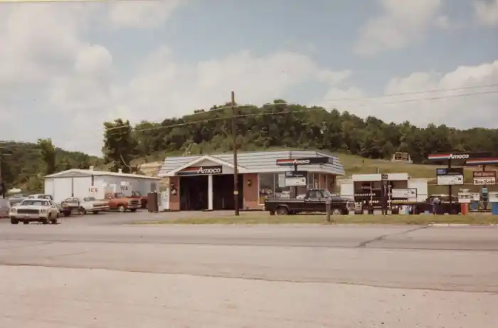
The small restaurant at 1709 W Osage (New China) is what remains of an Amoco Gas station. The picture below shows it in 1983. The original office is still standing.
Long Gone spots ❌
West of this point, nothing remains of the old Route 66 buildings in Pacific, but we will mention some of them below.
Ok Motel
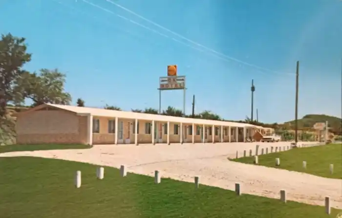
Just ahead, where the Mobil station is now located, was the OK Motel built around 1961 and torn down in the early 1990s. It was operated by Mr. and Mrs. Walter Crook, offering "New - Modern Pleasant Rooms - TV - Air Conditioned - Electric Heated." Here, in 1981, Michael Snyder, a high school student, stabbed the 63-year-old motel owner, Mittie Morris, to death.
Brouster Cabins
On the SW corner of Lamar Parkway and W. Osage was Benjamin Brouster's tourist cabins, gas station, and farm produce stall.
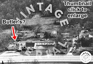
Butler's Cafe? and motel. Source
Butlers Cafe (?) and Motel (unnamed)
Almost reaching Gray Summit, to your left at 2960 W Ossage (now Mid Coast Performance). The building on the left (see red arrow thumbnail) looks like the also-razed Buttler Cafe and Station. It can be seen in this aerial photograph. The motel was long, narrow, and parallel to the highway.
This leg of your Route 66 road trip ends here, drive west into Gray Summit to keep on enjoying the Mother Road!

Sponsored Content
>> Book your Hotel in Pacific


Credits
Banner image: Hackberry General Store, Hackberry, Arizona by Perla Eichenblat
Architectural - Historic Survey of Route 66 in Missouri and Detailed Survey, Maura Johnson. 1993
Jack DeVere Rittenhouse, (1946). A Guide Book to Highway 66

