Fenton: Home of the Pink Elephant
Index to this page
About Fenton Missouri
Facts, Trivia and useful information
Elevation: 433 ft (132 m). Population 4,022 (2010).
Time zone: Central (CST): UTC minus 6 hours. Summer (DST) CDT (UTC-5).
Fenton is a city whose northernmost fringes touch old Route 66. It is located in St. Louis County, on the western side of the Meramec River in the central-eastern Missouri. Here is the first of three bridges that carry Route 66 across the Meramec river, the other two are further west, in Times Beach and Villa Ridge.
History of Fenton
Eastern Missouri has been inhabited for the last thousand years and Native Americans built two conical earth mounds here, the "Fenton Mounds" ca. AD 1050 - 1400, now gone (leveled for a Wal-Mart Supercenter in 2001) which are associated with those found in nearby Cahokia Mounds State Historic Park in Illinois. They were related to the historical Indians who were members of an Algonquin nation known who called themselves "Illiniwek" which meant "men" in their language; a group of hunter-gatherers who grew crops of corn and squash.
French explorers from Canada arrived in 1683 and named it after their king Louis XIV: "Louisiana", they also deformed the Indian's name to "Illinois". France lost the territory to Spain in the mid 1700s. The city of St. Louis was settled in 1764 by Laclede and Chouteau; and the first settlers in what would become Fenton arrived in the 1770s. Napoleon recovered Louisiana from Spain in 1800 but sold it to the U.S. in 1803 as he needed the cash to wage war against England.
St.Louis incorporated as a municipality in 1809 and the Territory of Missouri was established in 1812 and William Lindsay Long, who had migrated from England to the U.S. founded Fenton in 1818; he chose a spot on the western side of the Meramec River southwest of St. Louis. The State of Missouri joined the Union in 1821.
The Name: Fenton
Long is said to have named the town after his mother's supposed noble ancestor, the Earl of Fenton or, according to another version after his Welsh grandmother, Elizabeth Fenton Bennett. The surname "Fenton" comes from the Old English words "Fenne" = "marsh" and "Tun" = "fenced enclosure".
During the 1830s, the Illinois people and the other natives in Missouri were forcibly relocated to reservations in what is now Oklahoma. This opened the way to more white settlers in the region. Fenton's post office opened in 1833 as did the ferry across the Meramec River and replaced in 1854 by a covered toll bridge. It incorporated in 1874 and again in 1948.
It was a small farming community until the mid-1950s. Linked by MO-141 to Route 66 in the north and I-55 in the southeast. Missouri Hwy 30 linked it with Affton and downtown St. Louis in the east and with St. Clair on Route 66 in the west. It hardly had any association with Classic Route 66.
Chrysler chose the town for a large plant, that opened in 1959. This led to a growth in population as laborers flocked to the area. A second plant was built in the 1960s to manufacture light and medium sized trucks. The crisis of 2008 led to the closure of both plants in 2008 and 2009 respectively.

Lodging in Fenton, Missouri
Find your accommodation in town:
> > Book your hotel room in Fenton
More Lodging near Fenton along Route 66
There are several hotels in the area close to this town. Alternatively you can also find your accommodation along Route 66 in the neighboring towns and cities in Missouri. We list them below (from east to west):
On Route 66's Main alignment in MO
Eastwards
Westwards
- Hotels in Kansas
- Baxter Springs KS
- Galena KS
- Riverton KS
- Hotels in Oklahoma
- Miami OK
>> Check out the RV campground in Fenton
Weather in Fenton
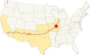
Location of Fenton on U.S. Hwy. 66
Fenton has four well marked seasons. It is located in the area where humid continental climate shifts towards a humid subtropical climate, so summers are hot and humid while winters are cold. It gets cold Arctic air and hot damp tropical air from the Gulf of Mexico. Spring is wet and may have extreme weather (tornados, thunderstorms and even winter storms). Fall is sunny and less humid, with mild weather.
The average high in winter (Jan) is a cool 39.9°F (4.4°C) while the average low is a chilly 23.7°F (-4.6°C). The summer (Jul) average high is 89.1°F (31.7°C) and the average low is 71°F (21.7°C).
Rain is on average 41 in. (1.041 mm) with the rainiest months being May through July with over 4.1 in monthly (104 mm). Snow falls between Nov. and Apr., with a total snowfall of 17.8 in. (45 cm). Relative humidity ranges averages 69.7% and is fairly stable year round.
Tornado risk
Fenton is located in Missouri's "Tornado Alley" and St. Louis County is struck by some 7 tornados every year.
Tornado Risk: read more about Tornado Risk along Route66.
Map of Route 66 in Fenton Missouri
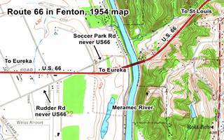
The original alignment through Manchester and Wildwood to Gray Summit was replaced in 1932 with a shorter and straighter one, it crossed the Meramec river twice, once here, in Fenton, and again in Times Beach.
The bridge was built at Sylvan Beach, but its was eliminated when I-44 and I-279 were built through this area.
We have seen a webpage indicating that Route 66 from 1933 to 1954 adopted a course along what now is Soccer Park Rd. west of the Meramec river, crossing to what now is the south side of I-44, and continuing with a SW course along Rudder Rd., and then heading west along Horan Dr. until meeting I-44 again at present Exit 272. But a careful analysis of USGS Maps of 1940 and 1954 (Kirkwood 1:24,000) disprove it. See image -click for large size map. It is clear that the old 1932 Route 66 roadbed ran along what now are the westbound lanes of I-44.
West of the Meramec, Route 66 was removed when I-44's roadbed was built over it. Nothing remains of the original road until you reach Times Beach. It is a 9.2 mile drive from the Meramec River in Fenton to Times Beach. This is Map with Directions, the whole of the 1933-1950s US 66 is buried beneath I-44 except for the final part, when you turn off the freeway at Exit 266, which is the original road.
1950s: Four Lane Freeway
By the early 1940s Route 66 was becoming congested and the heavy traffic made it unsafe. The war truck traffic made it even worse. But it was gradually improved: Rittenhouse mentions in 1946 that "From here (Gray Summit) into St. Louis, US 66 has three or more lanes.".
We have seen a webpage indicating that Route 66 from 1933 to 1954 adopted a course along what now is Soccer Park Rd. west of the Meramec river, crossing to what now is the south side of I-44, continuing with a SW course along Rudder Rd., and then heading west along Horan Dr. until meeting I-44 again at present Exit 272. But a careful analysis of USGS Maps of 1940 and 1954 (Kirkwood 1:24,000) disprove it. The old road ran along the north side of present westbound I-44's lanes.
The state petitioned in 1962 to have the Interstate renamed as I-66 instead of I-44, but this was denied by the AASHTO because the number "66" had already been used elsewhere. The old four lane US-66 ⁄ I-44 Freeway was improved again in Missouri after 1965, and the old US 66 was upgraded to Interstate standards.
The Route 66 alignment in Fenton
Visit our pages with old maps and plenty of information about US 66's alignments.
- Gray Summit to Rolla (next)
- Route 66 St. Louis to Gray Summit (In Fenton)
- Route 66 Hamel IL to St. Louis MO (previous)
Route 66 Sights in Fenton
Historic context, the classic Route 66 in Fenton
Fenton is not mentioned in the WPA travel guide "Missouri, a guide to the "Show Me" state" published in 1941 and Jack DeVere Rittenhouse in his classic "A Guide Book to Highway 66" published in 1946 does not mention it either. There was little relationship between Route 66 and Fenton in those days, as US 66 grazed the northern tip of the city, which at that time did not even comprise the area where Route 66 was located. It was a rural area with a few gas stations and inns.
In the 1962 USGS map (click on it to enlarge)you can see where the town of Fenton is lcoated (red arrow). There were three airfields in the flat terrain next to the Meramec River: Weiss, Sylvan Beach, and Meramec Airfields. Route 66 east of the Meramec River has "4-lanes" (red arrow) and the whole area is open countryside with no urban or suburban sprawl along the highway.
Route 66 road trip in Fenton, a city tour
Begin this leg of your on the western side of the Meramec River, exit I-44 at Exit 274 see this Map with directions. Here, on the top of the hill is the site of a classic motel.
Site of Hill-Top Motel
The motel is to your right, its poscard announced that it had "Ranch style construction, new and modern, large rooms. Comfortable beds". It had a curved layout and catered to travelers and those visiting the neighboring car manufacturing site. See it in this aerial photo taken in 1968. It was torn down.

Hill top Motel c.1970. Source.
Chrysler Plant
Chrysler's plant opened on July 1, 1959. It started producing Valiants, Dodge Darts and Plymouths. The cars were shipped by rail to dealerships across the nation. In the early 1960s St. Louis wes the second largest producer of cars in America. A truck manufacturing site opened next to it in 1966. The automobile plant remained in operation until 2008, the truck plant closed in 2009. The place was torn down. This is the map showing the site.
Former BP Service Station
870 S Hwy Dr, Fenton
Now converted into a pawn shop, the Missouri Gold Buyers, it was a 1950s BP gas station. It is a gabled building flat-roofed canopy with the pumps gone. It has an office and a two-service-bay garage. It sold BP gas until the late 2000s. It is, nonetheless a well preserved example of a gas station type built during the early 1950's and BP used this home-like style across the US (see this station in Fair Haven, VT as an example).
You can see it in this 1968 aerial photo.
1950s BP gas station on Route 66 in Fenton, Missouri
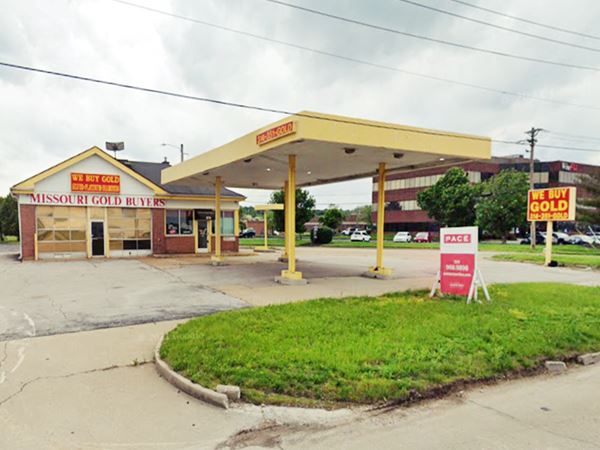
Drive east along the south service road andat 650 S. Hwy Drive, to your right is the site of another Route 66 motel:
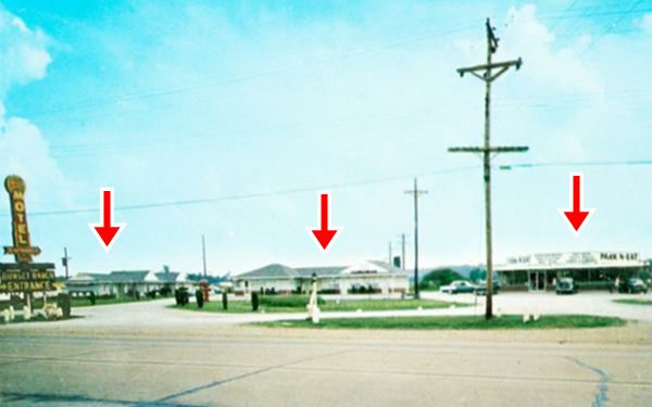
Sunset Ranch Site
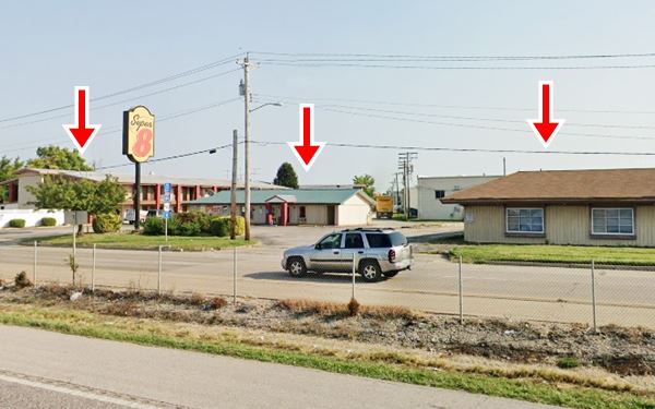
Sunset Ranch Motel which opened in 1952 has been greatly modified and altered, the red arrows in the "then and now" sequence below show the buildings and the modifications. It had "... soft water and electric heating, the Park n' Eat restaurant -also gone- was next to it.
There were several motels along this part of Route 66, serving not only the highway travelers but also those using the nearby Weiss Airport, but all have gone, including the airport. A Super Motel 8 stands on the former Ranch site.
Side trip to the Pink Elephant
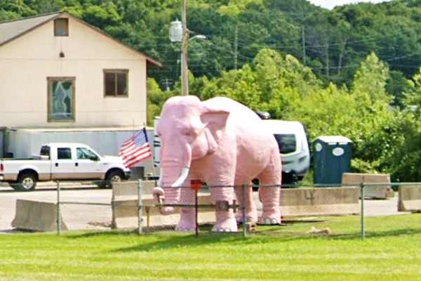
Pink Elephant
Americana & Wacky attractions
The elephant is located 10 miles south of the old Sunset Ranch motel, at 2599 MO-141, Fenton. See this map with directions.
It is pictured at the top of this page and also in the thumbnail image.
It is a great example of "Americana" and wacky attractions, a large statue of a Pink Elephant. This life-sized elehant is what remains of a former mini-golf: the Pink Elephant Batting Cage & Mini Golf. It is now part of a gas station on MO-141.
Return to Route 66 for one final sight in Fenton. See this map with directions.
Former Gulf Gas Station
At 165 N Outer Rd. in Valley Park, on the north side of the freeway at its exchange with MO-141. This is a 1940-50s former Gulf gas station with some typical design features used by Gulf at that time: a single-door entrance with a transom on the angled corner on the left side of the building. Banding running around the top of the building, just above windows and doors, and a Streamlined (Moderne) style. Now it is a junkyard selling scrap metal.
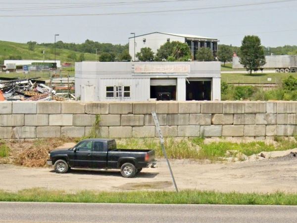
This is the end of your Route 66 road trip in Fenton ends here, drive west towards Times Beach (Route 66 State Park) and Eureka to continue your journey.

Some sponsored content
> > Book your Hotel in Lebanon

Source
Banner image: Hackberry General Store, Hackberry, Arizona by Perla Eichenblat
Jack DeVere Rittenhouse, (1946). A Guide Book to Highway 66


