
Arizona & Route 66
Index to this page
About Arizona
Facts, Trivia and useful information
Area: 113,990 sq. mi. (295.234 km2). Population: 7,453,517 (2023 est.).
Width: 310 mi. (500 km). Length 400 mi. (645 km)
Time zone (along U.S. 66 alignment): Mountain: UTC minus 7 hours. No Summer (DST) in most of the state (Navajo Nation has DST: UTC -6).

State Facts
Name: Arizona
The Spanish conquerors took the Native American words "ali sonak" (O'odham language) which meant: "small spring" and used them to name the region around a mine at Planchas de Plata; it later expanded to the whole region.
- Nickname: "The Grand Canyon State".
- Motto: "Ditat Deus" (God enriches)
- State Song: "The Arizona March Song"
- Capital: Phoenix
- Highest point: Humphreys Peak, 12,637 ft. (3.852 m)
- 14th most populous state in the US.
- Sixth largest state in America.
- Admitted as the 48th state of the Union on February 14, 1912
- Route 66 length in Arizona is 388 miles (624 km), the second longest after New Mexico.
Petrified Forest National Park, the only National Park on Route 66

Arizona's History

Arizona has been inhabited for over 10,000 years. The historic Native tribes were the Anasazi and Mogollon people. The Spanish explored the region in the 1540s seeking the mythical city of Cibola.
The Jesuits established missions in the late 1600s and Arizona became part of the Spanish Viceroyalty of New Spain which encompassed Mexico. It passed on to Mexico after its independence in 1821 as "Nueva (New) California".
After the American-Mexican War (1846-48), it was annexed by the U.S., and President Lincoln established the Territory of Arizona in 1862. Fifty years later it gained statehood.
Arizona's sunny and mild climate attracted a growing flow of population after WW II and it still does so.
Geography

The southern part of Arizona is the Desert Basin and Range region, but the northern part (The Colorado Plateau) is an arid upland area with many canyons and some mountain ranges.
Within this region are the Painted Desert and Petrified Forest National Park, as well as Humphreys Peak, the highest point in the state, at 12,633 ft. (3,853 m). The mountains have a beautiful pine forest coverage.
The Grand Canyon is one of Arizona's best known sites: a 1 mile (1,6 km) deep gorge carved by the Colorado River with steep walls and colorful strata of rocks. It is some 280 miles long and 4 to 18 miles wide (447 km long by 6 to 29 km wide).

Monument Valley in northeastern Arizona and the Barringer Meteor Crater are other well-known features.
Barringer Crater seen from the air.

Though Earthquake risk is low, there have been tremors in Flagstaff in the early 1900s. And one 5.6 magnitude earthquake shook Fredonia -near Utah- in 1959.
Arizona's Climate
The region through which Route 66 runs, crosses the dry and arid or semi-arid regions of the state, which have a Semiarid Steppe Climate. This northern part is cooler than the southern areas of Arizona.
The rainy season takes place during summer (when the moisture from the Pacific and Gulf of Mexico is blown across the state), causing thunderstorms. Early winter is also a rainy period.
Snow
Despite being very hot in summer, the winters are cold, and snow is frequent. At any time between November and late March, storm systems moving in from the Pacific Ocean can cause heavy snow in the high mountainous areas of central and Northern Arizona. The Grand Canyon's South rim receives 60 inches (1.3 m) of snow in winter, its North rim 144 inches (3.2 m).
Flagstaff NM, on Route 66, has an average yearly snowfall of 100.3 inches (254.76 cm) and is one of the snowiest incorporated cities in all of the United States.
Snow on Route 66, winter 2019

The area with highest rainfall is the high region around Flagstaff, becoming drier to the east and west of that town. The area with least rainfall along U.S. 66 is between Oatman and the Colorado River.
The average relative humidity is low, and the highest is found in Flagstaff: 55%.
Altitude and dryness causes large variations in temperature between day and night, even in summer.
Route 66 in Arizona

Cities
The Metropolitan area of Phoenix has a population of over 4.72 Million (2023); Tucson has over 1 Million. On route 66 is Flagstaff (Pop. 77,047)
Around 190,000 people live along Route 66's corridor through Arizona.
Culture
In Arizona you will find plenty of Native American mementos and handicrafts, especially in the Native Reservations.
Hotels: Where to Stay in Arizona
Accommodation in Arizona
The towns along Route 66 in AZ offer different lodging options. Check out some of the hotels and motels in the main towns below:
- Chambers
- Holbrook
- Twin Arrows Resort
- Winslow
- Flagstaff
- Bellemont
- Williams
- Ash Fork
- Seligman
- Grand Canyon Caverns
- Peach Springs
- Kingman hotels
- Yucca
- Sedona
- Valle
- Tusayan
Colorado River: Resorts
- Mojave City Arizona
- Havasu City Arizona
- Bullhead City Arizona
- Laughlin Nevada
You are so close to Las Vegas!
Click on Deals: Opens in new window
Grand Canyon Hotels
Click on Deals: Opens in new window
Driving an RV?
Check out our webpage: RV and Motorhome Parks & Campgrounds in Arizona.
> > Book your Hotels in Arizona
Map of Route 66 through Arizona
Interactive Route 66 map in AZ
> > Visit our Arizona Route 66 map.
It has the location of each town with a clickable icon. Click these links on the map to learn all about attracions, sights, landmarks Route 66 icons and more.
US 66 is color coded showing its different alignments over the decades.
Route 66 itinerary across Arizona
Each of thse pages has vintage maps and custom interactive maps.
Arizona has many stretches of original highway and amazing natural spots like the Grand Canyon and the Petrified Forest, Route 66's itinerary from east to west begins in Lupton and ends on the Colorado river in Topock:

Thumbnail of the 1935 Arizona highway map. Credits
Click on thumbnail map to enlarge
The Frontier Motel and Café

Towns located on Route 66 in Arizona
Click on the links below for complete information on each town and village
List of Route 66 Towns in Arizona from east to west
A list of Route 66 Attractions in Arizona
Below we list the main attractions along Route 66 in Arizona. In each category, they are listed from east to west along US 66.
Attractions listed in the National Register of Historic Places
Listed in the National Register of Historic Places

Area 66, Yucca, Arizona
Historic Querino Canyon Bridge
Little Lithodendron Wash Bridge (Sanders)
Route 66 Canyon Diablo Bridge
Historic Route 66 bridge (Winona)
Trails Arch Bridge 1916 - 1947 US 66 Bridge (Topock)
Other sites: Hotels, districts, and more
Historic Painted Desert Inn (Holbrook)
South Central Av. Commercial Historic District (Holbrook)
Bucket of Blood Saloon (Holbrook)
Historic Navajo County Courthouse & Museum (Holbrook)

Monte Vista Hotel in downtown Flagstaff. Credits
Hubbell Trading Post (Winslow)
La Posada Hotel (Winslow)
Winslow's Historic Commercial District
Flagstaff Historic Downtown District

"Zoomie" the apatosaurus. Grand Canyon Caverns. Credits
Williams Historic Downtown District and Urban Route 66
Historic Valentine School
The Kingman Comercial Historic District
The historic Durlin (Oatman) Hotel in Oatman.

Here it is! in Joseph City.
Classic Route 66 Motels
Chieftain motel (Chambers)
Holbrook Motels
Woods Inn
Hiway House Motel
Brad's Motel
Western Motel
Whiting Motel (West Holbrook)
Whiting Motel (North Holbrook)
City Center Motel
Wigwam Motel

Motel Sign, Kingman
Sun-n-Sand Motel
Sandman Motel
Desert View Motel
Moenkopi Motel
Motel Tonto
Holbrook Motel

The Corral
El Rancho Motel and Restaurant
66 Motel
Winslow Motels
Travel Lodge Motel
Navajo Lodge
Bazell Modern Court
Marble Motel

1932 Studebaker, US 66 Holbrook. A. Whittall
Flagstaff Motels
Weatherford Motel
Downtowner Motel, Motel Sierra Vista and DuBeau Motel Inn
L Motel
Lane Motel
Western Hills Motel
Motel 66

The Hi-Line Motel neon sign in in Ash Fork
Geronimo Motel
El Pueblo Motor Court
Pine Breeze Inn (Bellemont)
Maurice's Motel & Cafe (Parks)
Wagon Wheel Lodge (Parks)
Williams Motels
Fray Marcos Hotel
Grand Canyon Hotel
El Pinado Hotel
Bethel's Motel
Sun Dial Motel

Whiting Bros. Motel sign, Yucca
A. Whittall
Norris Motel
Bell Aire Motel
Westerner Motel
Thundirbird Motel
El Rancho Motel

Supai Motel neon sign. Seligman. Credits
Mt. Williams Motel
Del Sue Hotel
Hull's Motel Inn
Sutton Motel
Highlander
Gateway Court
The Clock Motel
Seligman Motels
Court Deluxe Motel
Historic Cottage Hotel
Supai Motel
Aztec Motel
Bill-Mar-Den - Stagecoach Motel

View of Main St. in Oatman, A. Whittall
Truxton Motels
Frontier Motel and Café
Barker Apartments
The Orlando Motel
Chief's Motel (Valentine)
Ranchero Motel (Antares)
Kingman Motels
Siesta Motel
El Trovatore Motel
Arcadia Lodge
Astro - Space Age Motel
Travelodge Motel
Brandin' Iron Motel
If you visit Las Vegas
Some tours and sightseeing
Sponsored

Oatman Hotel sign. A. Whittall
Hill Crest Motel
Hill Top Motel
Ranchito Motel
Pony Soldier Motel
Lido Motel
Skyline Motel
Yucca Motels
Joshua Motel & Café
Whiting Bros. Motel and Gas Station signs
Historic Districts
Holbrook - South Central Av. Commercial Historic District
Winslow's Historic Commercial District
Flagstaff Historic Downtown District
Williams Historic Downtown District
Seligman Historic Downtown District
The Kingman Comercial Historic District
Bridges

The Topock Bridge, Arizona & California
Thad Roan
Allentown with a Historic 1923 bridge. (Allentown)
Railway bridge (Canyon Diablo)
Historic Route 66 bridge (Twin Arrows)
Route 66 Bridge (Seligman)
Crozier Canyon Bridge (Valentine)
bridges across the Colorado River (Topock)
Trading Posts, Cafés, Shops, Stores, Diners....
Painted Cliffs Stores and trading posts (Lupton)
Painted Desert Trading Posts (Holbrook)


Former Stuckeys Holbrook, nowadays source, Knife City Outlet.
Plainsman Restaurant (Holbrook)
Rainbow Rock Shop with its dinosaur statues, (Holbrook)
Joe & Aggie's Cafe (Holbrook)
Howdy Hanks (Joseph City)
Ella's Frontier Trading Post (Joseph City)
Visit the Jack Rabbit Trading Post (Joseph City)
Entré Restaurant (Winslow)
Dome shaped Trading Post (Meteor city)
Toonerville Trading Post (Toonerville)
Twin Arrows Trading Post

Kingman diner. A. Whittall
Valentine Diner (Twin Arrows)
Winona Trading Post
Granny's Closet - Lumberjack diner (Flagstaff)
Parks General Store (Parks)
Snow Cap Drive-In (Seligman)
Angel & Vilma Delgadillo Gift Shop (Seligman)
Historic Seligman Sundries
Black Cat Bar (Seligman)
Historic Peach Springs Trading Post
Jade Chinese Restaurant (Kingman)
Casa Linda Café (Kingman)
Cool Springs (Kingman)
Honolulu Club (Yucca)

Standin' on a Corner in Winslow Arizona
A. Whittall
Classic Service Stations
Former Stuckey's
Old Richfield Service Station
Texaco Station
Red Cross Garage
John Osterman Shell Station
Old Texaco Service Station
Truxton Service Station
Union 76 service station
Mobile Service Station Kingman
Service Station in Kingman
Shell Service Station Kingman


Ghost Towns
Ghost Town
Canyon Diablo ghost town
Ghost Town (Toonerville and Twin Arrows
Chloride, a mining ghost town (near Kingman)
Santa Claus (near Kingman)
Goldroad, Mining Ghost town
Other Landmarks and Route 66 Kitsch

Dinosaurs at the Rock Shop in Holbrook
Cars animated movie location (Lupton)
Replica of Fort Courage (Houck)
Dinosaur statue and US66 shield
Standing on a Corner (Winslow)
Leupp Village
Internment camp for Japanese Americans during World War II (Leupp)
World's longest map of Route 66 (Meteor City)
Site of Rimmy Jim's Trading Post -gone- (Meteor Crater)
Meteor Crater Observatory ruins
Barringer Meteor Crater
Canyon Diablo gorge (Two Guns)
Apache Death Cave (Two Guns)
Twin Arrows Navajo Casino Resort

Twin Arrows, Route 66, Arizona
Grand Canyon Caverns (Peach Springs)
The Cowgill's signpost (Truxton)
Crozier Canyon (Valentine)
Valentine Post Office (Valentine)
Hackberry General Store (The Northside Grocery at Hackberry)
Giganticus Headicus (Antares)
Grand Canyon Skywalk (near Kingman)
Area 66 UFO museum and sphere (Yucca)
Truck on a Pole (Yucca)
Sitgreaves Pass (Oatman)
Gunfights and wild Burros (Oatman)

Frontier Motel, Truxton
Route 66 Historic and Scenic Byways
original 1926 alignment from Allentown to Sanders
Historic Urban Route 66 in Williams
Historic Segments of Route 66 in Parks
Historic Segment Ash Forks - Kingman
Main Street Seligman
The Historic Route 66 Back Country Byway Kingman to Topock.
Museums, Scientific and Native American Sites
Lowell Observatory (Flagstaff)
Museum of Northern Arizona (Flagstaff)
Dean Eldrege Museum (Museum club) (Flagstaff)
Keyhole Sink Rock Art (Williams)
Parks and Outdoors
Petrified Forest National Park (Holbrook)
Little Painted Desert (Winona)
Grand Falls on the Little Colorado River (Winona)
Coconino National Forest (Flagstaff)
Ruins of Elden Pueblo (Flagstaff)
Red Rocks State Park (Flagstaff)
Wupatki National Monument (Flagstaff)
Sunset Crater National Monument (Flagstaff)
Monument Valley (NE Arizona)
Grand Canyon National Park (from Williams or Flagstaff).
Diamond Creek (Peach Springs)
Lake Havasu State Park (near Yucca)
Route 66 itinerary across Arizona
A detailed description of the alignment of U.S. 66 through Arizona, from East to West, with the main towns, attractions and sights.
Arizona
Current mileage: 396 mi.
Route 66 crosses the state of Arizona from Lupton on the New Mexico state line to Topock on the Colorado River next to California. The old alignment runs mostly parallel to I-40, except for a long intact stretch between Seligman and Flagstaff.
Arizona Route 66 Trivia
Williams was the last point on the whole of US 66 to be bypassed by an Interstate.
See our Lupton to Winslow webpage full details, description and maps.
From the New Mexico state Line, mile zero, go west along Grant Road until Exit 359, where you should cross to the South Frontage Rd. of I-40 and head west (0.5 mi.) Pass by Lupton. Just west of Exit 351, (8.5 mi.) at the fork go left along Allentown Rd. Also visit Allentown, and then right along Apache County Road 7240 - the 1920s alignment of Route 66. At Houck is the historic Querino Canyon Bridge (Exit 348).
When you reach US 191 by Sanders (21 miles), go right and cross I-40 (Exit 339) to the North Frontage Road. Head west. At Chambers (28 miles) you will have to go south and access I-40 at Exit 333, head west.
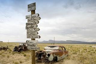
Abandoned Cars,US66. Carol Highsmith
Leave I-40 at Exit 330 and cross to the south Frontage Road (32 mi.). The paving ends (38 miles) but you can cross under I-40, to its north side. Here, to the south of I-40 is Navajo. Keep along the North Frontage Rd. (Pinta Road) and enter the Petrified Forest National Park
The road ends at Park Road (50 mi.), well inside the Nat. Park. Go right to visit the Historic Site: Painted Desert Inn, or take a left and pass the Painted Desert Visitor Center reaching I-40 at Exit 311, head West along I-40, (51 miles).
At Exit 303, you can stay on I-40 until reaching Holbrook, or test your luck on the old 1920s dirt surfaced US. 66: at Painted Desert Indian Center, (59 mi.) take the south Frontage Rd. west. It becomes Goodwater Rd., Coyote Rd., and crosses to the north of I-40. Take a left (65 miles) along Pima St. in Sun Valley, in the outskirts of Holbrook.
Holbrook
Get onto I-40 at Exit 294 (68 miles) and take exit 289 onto I-40 Bus. Loop (73 mi.) into Holbrook, it crosses I-40 and enters the town.
Take a right along US 180 (W. Hopi Drive through town) and see the Wigwam Village Motel #6 (Historic Site) on your left. It is one of the two surviving Wigwam Motels on US 66.
Get onto I-40 West at Exit 285 (78 mi.). The old US 66 alternates as the south and north frontage. Exit I-40 at 277 (86 miles) and head into Joseph City along hwy 40B, the Main St. was U.S. 66. (87 mi.). Return to I-40 at exit 274, go west.
Leave I-40 at Exit 264 (98 miles), follow Hubbard Rd. (on the north side of the Interstate, west) it will merge with I-40 at Exit 257 (105 mi.), cross to the south side and enter Winslow along I-40 Bus. Loop (E 3rd St.).
Winslow

Route 66 the Main Street, Seligman
A. Whittall
Follow US 66 through the center of the town, and turn left on N. Kinsley Ave. one block, to 2nd St., to the site of "Standing on the Corner", (109 miles). Don't miss the La Posada Historic District.
See our Winslow to Winona webpage with full details.
At Exit 252, (112 mi.) get back onto I-40 west. The N. Frontage Rd. is the old US 66, a dirt road in this part. You will drive past Leupp Corner and MeteorCity.
If you enjoy dirt roads, take Exit 233 (130 miles) south and head south towards Barringer Crater (Meteor Crater), which is 6 mi south of I-40. At the southern tip of the RV Camp is Route 66 with a NW - SE direction, go right. Enjoy the old road. Stop at Two Guns at Exit 230 and get back onto I-40 west. At Exit 219 is Twin Arrows (145 mi.).
You will see US 66 (Now AZ-394 on the right side, inaccessible from I-40 unless you drive back eastwards along it at the following exit: get off at Exit 211 (154 miles) here you can go east. Head north into Winona along AZ-394 Townsend - Winona Rd. See the Historic Walnut Canyon Bridge.
Suddenly after all that desert, pine trees appear and so do the hills.
Flagstaff and Winona are both mentioned in the song Route Sixty-six (Get your kicks...).
Visit our Winona to Williams webpage for this section's description.
Keep straight until meeting US 89, at Flagstaff (164 mi.) and take a left towards the town.
Flagstaff
US 180 will join from the left with I-40 Bus. Loop. And you will pass by the historic Railway Station (172 miles) in Downtown Flagstaff (Railroad Addition Historic District and Boundary Increase). Use I-40 Bus. Loop to leave town.
Just north of town is Humphrey's Peak (12,633 ft. - 3.853 m), the highest point in Arizona, and site of the Arizona Snowbowl ski center.
Get onto I-40 at Exit 191 west (178 mi.). At the next Exit at Riordan, (190) is the Arizona Divide with 7,335 ft. (2.237m) the highest point of the road in Arizona.
You can reach Williams along I-40 or follow the old Route 66 from Bellemont (visit the Pine Breezes Inn first): Take Exit 185 north along Hughes Ave. and a left onto Old Hwy 66. (184 miles) - Branningan Park Rd. Leave Exit 178 behind, pass by Parks, (192 miles) head west and pass Exit 171 (198 mi.) and keep along Deer Farm Rd. until Exit 167 (203 mi.) and go to the south side of I-40 and follow AZ-51A west to Bearizona Park on US 66, (210 miles) turn left towards Williams.
Williams

US 66, Main Street in Williams
A. Whittall
Pass through the center of Williams (212 mi.) along its Historic Commercial District and Urban Route 66. See its Motels and the Railway Station with its steam engines is an interesting sight. The trains go up to the Grand Canyon.
Visit our Williams to Kingman webpage for a complete description of this leg.
Get back onto I-40 west at Exit 161, keep west until Ash Fork Exit 145, into Ash Fork. Go right (229 miles) along Lewis Ave. and Return to I-40 at Exit 144.
At Exit 139 (236 mi.) leave I-40 for the longest stretch of intact road surface of US 66 in the U.S., Arizona Historic Route 66, it has been placed on the National Register of Historic Places. Head west towards Seligman.
Seligman
Drive through the historic town along Chino St. (254 miles) and head west. But first stop at Delgadillos Historic Route 66 visitor Center. Delgadillo promoted the AZ Route 66 Association. The Central District is a Historic Site.
The road passes by the Grand Canyon Caverns (279 mi.), and reaches Peach Springs (291 miles).

DeSoto's Beauty and Barber Shop Ash Fork
Peach Springs
This is Indian territory, it is part of the Hualapai Indian Reservation; visit the Peach Springs Trading Post. Keep west and reach Truxton (288 mi.) -with the Frontier Motel and Cafe, pass through Valentine (309 miles) with its Schoolhouse at Truxton Canyon Trading School (Historic Site).
Hackberry
The town Hackberry is tiny and off the road, but the Hackberry General Store, on the right (314 mi.) is worth stopping at. It was a general store and now is a gift -curio shop.
At 320 mi. the road turns to the SW at Antares (see the Giganticus Headicus) and runs straight into Kingman where US 66 becomes E. Andy Devine Ave, and enters the town, crossing I-40 (337 miles).
Kingman
The town's Commercial District is a Historical site.
The Avenue goes by the town, passes the Historic Powerhouse (341 mi.), and turns to the south becomes the south Frontage Rd. of I-40 and at Exit 44, crosses to the west (north) of I-40. Take a right along AZ-10, Oatman Road and head SW. (346 miles).
See our Kingman to Topock webpage for full details of this section.
The road reaches the Black Mountains (359 mi.) and crosses them in a very snaking course, with sharp curves, left and right zig-zagging up and down. Sitgreaves Pass (3,652 ft.), is the summit. The worst part is over, when the road turns south again (368 miles), and runs along the western flank of the mountains.
Kingman is mentioned in the song Route Sixty-six (Get your kicks...).

Truck on a Pole, Yucca AZ
Yucca
If you head along I-40 towards Topock, following the 1952-1977 alignment of US66, you will reach Yucca, in the desert. The original 1926-52 highway crossed the Black Mountains and went through Oatman.
Oatman
US 66 reaches Oatman (370 miles), an old mining town. Visit the Historic Durlin Hotel, Oatman.
Leave the town and then the mountains (380 mi.), to face the desert again, the "Wild Springs wilderness", reaching Topock (390 mi.).
Topock
The road passes Topock "bay" of Goose Lake and reaching Exit 1 of I-40 at 395 mi. Head west.
I-40 crosses the Colorado River; to the south is the Old Trails Bridge, Topock (Historic Site), cross the New Bridge, and leave Arizona to entering California. Mileage to this point (396 miles).
Some sponsored content
>> Book your Hotel in Kingman
Credits
Banner image: Hackberry General Store, Hackberry, California by Perla Eichenblat