

About California

Route 66 Motel Sign in Pasadena, California of the Hiway Host Motel
Facts, Trivia and useful information
Area: 163,696 sq. mi. (423.970 km2). Population: 38,802,500 (2014 est.).
Width: 250 mi. (400 km). Length 770 mi. (1.240 km)
Time zone
(along U.S. 66 alignment): Pacific (PST): UTC minus 8 hours. Summer (DST) PDT (UTC-7).
- Nickname: "The Golden State"
- Motto: "Eureka"
- Capital: Sacramento
- Highest point: Mount Whitney 15,505 ft. (4.421 m)
- Most populous state in America.
- Third largest state in the U.S., after Alaska and Texas.
- Admitted as the 31st state of the Union on September 9, 1850
- Route 66 length in California is 333 miles (536 km).
The "End of the Trail" sign on Santa Monica Pier

Name: California
Chivalry novels were popular in Spain during the 1400s and 1500s. One of them mentioned a mythical island located on the western coast of the Indies, named California after its Queen, Calafia.
The book ("Las Sergas de Espladian"), "The Adventures of Espladian" was written in 1510 by Garci Rodríguez de Montalvo.
By the way, Patagonia in Argentina also derived its name from a character of a chivalry novel (Patagón).
Strangely enough, California appeared on a map drawn by Michiel Coljn, of Amsterdam, as an island for the first time in 1622.
History of California
Human beings have been living in California for at least 10,000 years. It had over 70 different Native American groups during the historical period.
The Spanish sailed along its coasts in 1542 and incorporated it to the Spanish Viceroyalty of New Spain (current Mexico). In 1769 Spanish missionaries established towns around their missions, which would later develop into modern cities like Los Angeles (which in Spanish means: "The Angels") and San Diego ("St. James").
Route 66 in California

Mexico retained California after its independence from Spain in 1821, but a growing inflow of American settlers, miners and trappers would create unrest and revolts during the 1830s and 40s. The 1846 rebellion led to the creation of the California Republic and after the Mexican American War (1848), the area was ceded to the U.S.
It joined the Union in 1850 as a slave-free state. The transcontinental railroad linked it to the rest of the nation in 1869.

California, its Geography
The northern two thirds of the state are cut by the California Central Valley running parallel to the coast and bound on the west by coastal mountains and on the east by, from north to south, the Cascade Range, the sierra Nevada (Spanish for "Snowed Mountains") and the Tehachapi Mountains.
The southern third of the state (crossed by Route 66) is a relatively flat 1000 - 2000 ft. high arid area (The Mojave Desert), bound on the east by the Colorado River, and on the west by the Sierra Madre, San Rafael, San Gabriel, San Bernardino and San Jacinto Mountains.
To the north lies the depression of Death Valley and to the south another depression with the salt water Salton Sea Lake in the Colorado Desert.
California has a relatively high Earthquake risk: the The San Andreas Fault passes through Cajon Pass next to U.S. 66's alignment between San Bernardino and Victorville.
California's Climate
Its size and relief give it many different climate zones. US 66 crosses its Southern part, which has a Mediterranean Climate, cooler and less extreme along the Pacific coast, more continental and extreme further inland.
The coastal mountains block humidity from reaching the interior and create the deserts east of them: with hot summers and cold winters.
Death Valley has the record of highest temperature in the world (134°F - 57°C). Rainfall is limited in the Mojave Desert. July temperatures can range from the 105 to 75°F (40 - 24°C) in summer to 60 - 40°F (15 to 4°C).
The Mexican Monsoon or "Southwest Monsoon" funnels moisture from the Ocean (The Pacific and also the Gulf of Mexico) into the desert region of the Southwest causing strong thunderstorms with intense downpour over the mountains.
Tornadoes are extremely unlikely in this area.
Thunderstorm looming over the Mojave


Beverly Hills Plaque on Sunset Blvd. Traveljunction
Cities
Los Angeles (Pop. 3,884,307) and San Diego (Pop. 1,355,896) are the largest cities. Greater Los Angeles Area is the second-largest urban area in the U.S. with 18 Million residents in 2011. Eight of the top 50 cities in the US are located in California.
Around 2.15 Million people live along Route 66's corridor through California.
Culture
Californian Culture is a blend of Western US and Hispanic influences. It is often evoked as a land of freedom, a paradise along the Pacific coast, a high-tech, young society. The land of Hollywood, Disneyland and open-minded San Francisco.
Los Angeles is best known for its movie industry and the wealth and riches in Beverly Hills.
Where to Stay in California
Accommodation in California
The towns along Route 66 offer different lodging options. Check out the hotels and motels in the main towns.
Towns listed from East to West
Hotels & Motels
- Needles motels
- Barstow
- Helendale lodging
- Victorville
- Hesperia
- Cajon Junction
- San Bernardino
- Rialto
- Fontana
- Rancho Cucamonga
- Pomona hotels
- San Dimas
- Glendora
- Azusa accommodation
- Duarte
- Monrovia
- Arcadia
- Pasadena motels
- Hollywood
- Los Angeles
- Luxury Hotels in West Hollywood
- Beverly Hills
- Santa Monica
Near Needles...
- 26 miles. Laughlin Nevada Resorts
- 20 miles. Bullhead City Arizona
- 15 miles. Mojave City
>> Book your Hotel in California
Check out RV and Motorhome Parks & Campgrounds in California.
Map of Route 66 through California
Interactive Route 66 map in CA
See our California Route 66 map, with the location of each town, and links on the map that give full details on attracions, sights, Route 66 icons and more.
Towns located on Route 66 in California
From East to West
Click on the links below for complete information on each town and village
List of Route 66 Towns in California from East to West:
East
Choose the town for full details...
California
Alphabetical list of Towns

This photo of the Cucamonga Service Station (1915). Courtesy of TripAdvisor

A list of California's Attractions

Route 66 Motel in Needles, California. Renjishino
Cafes and Restaurants
Wayside Cafe (Essex)
Roy's Motel and Café (Amboy)
Old Ludlow Cafe (Ludlow)
Ludlow Cafe (Ludlow)
Bagdad Cafe (Newberry Springs)
Poes Café (Newberry Springs) Gone
Kelley's Restaurant Sign (Daggett)
The Iron Hog Saloon (Oro Grande)
Emma Jean's Café and Truck Stop (Victorville)
Summit Cafe (Cajon Pass)
Bono's Restaurant and Deli (Fontana)
The Magic Lamp (Rancho Cucamonga)
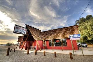
Bagdad Cafe, Newberry Springs, California, Vicente Villamón
Sycamore Inn (Rancho Cucamonga)
Tugboat Annie's (Claremore)
Mr. D's Diner (La Verne)
La Paloma Restaurant (La Verne)
Pinnacle Peak Steakhouse (San Dimas)
Golden Spur (Glendora)
The Hat Pastrami (Glendora)
Denny's Windmill Restaurant (Arcadia)
Gus's Barbecue (South Pasadena)
Ruins and Ghost Towns
Summit Cafe, Filling Station and cabins (Summit)
Bagdad (Bagdad)
Siberia (Siberia)
Calico Ghost Town (Daggett)
Singular McDonald's
First ever McDonald's (San Bernardino)
McDonald's "Golden Arches" building (Upland)
McDonald's "Golden Arches" building (La Verne)
Monrovia's McDonald's (Monrovia)
Route 66 Motels
Needles
Route 66 Motel
Palms Motel (Old Trails Inn)
Imperial Motor Inn
Desert Inn Motel

Roy's Motel and Café in Amboy Photographersnature
Chambless Camp (Chambless)
Roy's Motel and Café (Amboy)
Post Office and Motel (Ludlow)
Henning Motel (Newberry Springs)
Stone Hotel (Daggett)
Barstow
Cactus Motel
Town and Country Motel
Travelodge
Sands Motel
Sage Motel
Skyview Motel
La Siesta Motel
Casa del Desierto Harvey House
Desert Inn
Hillcrest Motel
Imperial 400 Motel
Casa Loma Motel
The Torches Motel
El Rancho Motel
Site of the Beacon Tavern

Two old trucks at the Service Station in Ludlow, Darin Marshall
Lenwood Radio Auto Camp (Lenwood)
The Dunes Motel (Lenwood)
Sage Brush Inn (Helendale)
Green Tree Inn (Victorville)
Green Spot Motel (Victorville)
New Corral Motel (Victorville)
More Classic Motels....
San Bernardino
Oasis Motel
Travelodge Motel
Sands Motel
Wigwam Motel
Cajon Motel
El Rey Motel (Rialto)
Rex Motel (Rialto)
Fiesta Motel (Rialto)

Detail of "History of Medicine Murals", Duarte, CA, photo: Gray Brechin
Red Chief Motel (Rancho Cucamonga)
New Kansan Motel (Rancho Cucamonga)
Stardust Motel (Pomona)
20th Century Motel (Glendora)
Palm Tropics Motel (Glendora)
Stardust Motel (Azusa)
Colonial Inn (Azusa)
El Rancho Motel (Duarte)
Aztec Hotel Historic Site (Monrovia)
The Leven Oaks Hotel (Monrovia)
Oak Park Motel (Monrovia)
Frontier Motel (Arcadia)
Flamingo Motel (Arcadia)
Hotel Shirley (Sierra Madre)
Pasadena
Pasada Motel
Vagabond Inn (former Imperial 400 Motel)
Astro Motel (Now Knights Inn)
La Casa Inn (Now Swiss Lodge)
Los Angeles
Lincoln Park Motel
The Motel de Ville
The Starlite Motor Hotel
The Paradise Motel
Hollywood La Brea Hotel
Former Temple View Travelodge
Casa Lu-An Motel
Eagle Rock Travelodge
Albert's Motel
Rose Bowl Motel
Pueblo Motel & Dining Room
Service Stations and Garages

The Giant Orange fruit stand at Bono's, Fontana CA
Wheelers Flying A Service Station (Needles)
Old Trails Inn gas station (Needles)
Service Stations (Needles)
Carty's Camp Shell station (Needles)
Roadrunner's Retreat (Chambless)
Wayside Cafe (Essex)
Richfield Service Station (Ludlow)
Old Filling Station (Ludlow)
Whiting Brothers (Dry Creek) Service Station (Newberry Springs)
Mugwumps Service Station (Daggett)
Barstow Garage (Barstow)
Old Service Station (Lenwood)
Polly Gas Station Sign (Helendale)
Watson's Richfield Station (Helendale)
Mohawk Service Station (Oro Grande)
Wilshire Service Station (San Bernardino)
Cucamonga Service Station (Rancho Cucamonga)
Vintage Gas Station (Pomona)
Art Deco US Gas service station (Glendora)
vintage service station (Azusa)
Flying A Service Station (Monrovia)
Monrovia Gas Station (Monrovia)
Antique Service Station (Monrovia)
"Shed" style gas station (Los Angeles)
Union 76 Service Station (Beverly Hills)

Wigwam Motel Route 66 San Bernardino.Marcin Wichary
Museums
Western America Railroad Museum (Barstow)
Route 66 Mother Road Museum (Barstow)
Mojave River Valley Museum (Barstow)
Desert Discovery Center (Barstow)
California Route 66 Museum (Victorville)
La Brea Tar Pits (Los Angeles)
Miscellaneous Sights: Oddities, Kitsch, Americana and interesting sights
Borax Wagon (Needles)
Mystic Maze (Needles)
Tom's Certified Welding & Machine Shop (Barstow)
Bottle Tree Ranch (Helendale)
Giant Orange (Fontana)
Oldest Winery in California (1839) (Rancho Cucamonga)
Giant Cup of Coffee (Upland)
GuinessRecord breaking Wisteria vine (Sierra Madre)
Fair Oaks Pharmacy and Soda Fountain (South Pasadena)
location for the "Halloween" Movie (South Pasadena)
Chinatown (Los Angeles)
Chicken Boy - giant statue (Los Angeles)
Sunset Strip (West Hollywood)
Rodeo Drive (Beverly Hills)
End of the Trail sign (Santa Monica)
Neon Signs
Taco King neon sign (Upland)
Vintage neon sign at Coates (Pomona)
Liquor Store Sign (Azusa)
Rod's Grill Neon Sign (Arcadia)
Fish-shaped neon sign at Camerons (Pasadena)
Bekins Storage Co. Roof Sign (Pasadena)
Cindy's Diner Sign (Los Angeles)
Hollywood Sign (Los Angeles)
Natural Landmarks
Amboy Crater (Amboy)
Pisgah Crater (Newberry Springs)
The San Andreas Fault (Cajon Pass)
Arrowhead (San Bernardino)
Movie Theatres and Drive In Theatres
Skyline Drive In movie theatre (Barstow)
Barlen Drive In Movie Theater (Lenwood)
Art Deco theater (Fontana)
Grove Theater (Upland)
Historic Pomona Fox Theater (Pomona)
Foothill Drive-In Theater (Azusa)
Rialto Theatre (South Pasadena)
Hollywood's Chinese Theatre (Los Angeles)
Route 66 itinerary across California
Detailed description of the alignment of U.S. 66 through California, from East to West:
California
Route 66 in California
Current mileage: 333 mi.
Route 66 crosses California from the Colorado River to the Pacific coast, from Needles to Santa Monica through the Mojave Desert and Los Angeles.
Full description of Route 66 across California from Santa Monica to Needles with its sights, attractions and landmarks. "Get your kicks" in sunny California.
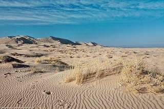
Kelso Dunes in Mohave Preserve California, "Mike" Michael L. Baird
We will start in the middle of the bridge on I-40, over the Colorado River, (mile zero), at the Arizona state line.
The original Route 66 Bridge is the steel arch bridge just south of I-40. It is a Historic Bridge, and it appears in the movie "Grapes of Wrath".
You are entering the driest part of the trip, the Mojave Desert region, which was the toughest on both drivers and vehicles in the old-days. Keep on I-40, which turns north, towards Needles.
Leave I-40 at Exit 148, (6 mi.) turn west and then north along Five Mile Road, and then north along U.S. 95, pass under I-40 (at Exit 144) and enter Needles.
Needles
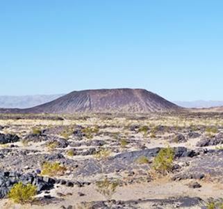
Amboy Crater, Amboy, California.
Visit the Historic El Garces and its Classic Motels. Go through the town (13 miles) and follow Broadway St. (US 66), follow it, and take a left at Needles Highway, pass under I-40 and keep north, the road (River Road) crosses I-40 again (Exit 141 - 16 mi.), follow the fork to the left along the National Trails Highway and return to I-40 at Exit 139 (18 miles).
Goffs
At Exit 133, (24 mi.) go north along U.S. 95 towards Goffs, then (30 miles) take a left along Highway 66. The road goes by Goffs (45 mi.) and curves to the Southwest.
Route 66 reaches I-40 at Fenner by Exit 107 (55 mi.). Keep South as the road goes on to meet the National Trails Highway with the post-1931 alignment south of I-40, heading with a Southwest course into Essex (visit the Wayside Cafe).
Road Closures
Updated Dec. 12, 2019
Since 2017 Route 66 has been closed west of Essex, all the way to Chambless. The road east of Essex to I-40's Exit 115 (Mountain Springs) is also closed. There is complete information, with maps at the San Bernardino County Road Closed web page).
Apparently Essex Rd. from Essex to I-40's exit 100 is open, so you can go along it, take I-40 westbound and then reach Chambless or Amboy and retake Route 66 by driving Kelbaker Rd. from Exit 78.
There is no expected reopening date for these sections.
Back to the itinerary (remember the road closures mentioned above): After Essex comes Danby and then Chambless (see the old Store, Cabins and Store there), finally reaching Amboy (94 miles) after crossing the desert with mountains to the north and south.
Amboy
See the vintage Roy's Motel and Café. The dark cinder cone of Amboy Crater is to the south of Route 66 next to the small town. The road skirts its lava field and turns Northwest passing by the ghost towns of Bagdad The driest spot in the USA and Siberia and reaching I-40 at Exit 50 at Ludlow (122 miles).
Ludlow
At Ludlow, pass under the Interstate and take a left along the north frontage road (National Trails Highway) towards the west.
Route 66 crosses to the south side of I-40, then crosses the railroad, and keeps westwards along the south side of I-40. West of the access to Exit 23 it passes by Bagdad Cafe, and reaches Newberry Springs, where it crosses I-40 at Exit 18 (154 mi.).
Follow the road along the north side of I-40 passing through Dagget (166 miles). When you reach Nebo St. you must take a left to return to I-40 (168 mi.) because although US 66 keep on straight, it enters a Marine Base.
Access I-40 via Exit 5 and just after the Base exit again (Exit 2 - 171 miles), pass under I-40 and take East Main St. towards the West, along the south side of I-40, entering Barstow (173 mi.).
Barstow
Both Barstow and San Bernardino are named in the song Route Sixty-six (Get your kicks...).
At Exit 1, follow Main St. to the north of I-40, cross I-15 and keep west. Visit the Harvey House Railroad Depot, a Historic Place with its two Museums.

The Torches Motel, Barstow, California. Highsmith, Carol M
The road arches round Barstow, crosses CA hwy 58 and takes a Southwesterly course.
Route 66 (National Trails Highway) will pass through small towns of Lenwood (179 miles), Hodge, Helendale (197 mi.), with its Polly Gas sign and Oro Grande (site of the Iron Hog biker stop) (205 miles).
It becomes North D St. and passes under I-15 at Exit 153, entering Victorville (210 mi.).
Victorville
Take a right onto Seventh St. southwards and at Exit 150 join I-15 southwards.
I-15 and the old alignment of Route 66 take a sharp curve towards the south through San Bernardino National Forest. You can take Exit 129 (234 miles) and follow Cajon Boulevard, on the west side of I-15. At Exit 124, Kenwood Ave. enter I-15 and keep to the left, along I-215 towards San Bernardino. After the interchange of I-15 with I-215 keep right and exit again, onto Cajon Blvd. (242 mi.) which will take you into San Bernardino.
San Bernardino
The Post-1930s alignment followed Kendall St. and then south along North E. St. until W. 5th St. where it turned west again.
Landmarks
It was on N. E St. where McDonald's opened their first Hamburger store. Don't miss the Wigwam Village #7, a Historic Site and one of the two surviving Wigwam hotels along U.S. 66.
Cajon Blvd. turns into Mount Vernon Ave. take it south until W. 5th St. and take a right (252 miles) . At Lytle Wash Creek it becomes Foothill Blvd. (CA 66).
The road goes through Rialto, Fontana (259 mi.) and Rancho Cucamonga (268 miles) with a westerly direction.
It keeps on west through a chain of towns: Upland, Claremont (275 mi.) , and then takes a NW course at La Verne, crossing CA 210 and going through San Dimas and Glendora (284 miles).
After Azusa it becomes Huntington Dr. through Irwindale, Duarte and Monrovia (with its historical Aztec Hotel), crosses I-210 (Exit 33 - 294 mi.) and keeps on westwards through Arcadia ( there is another town with the same name in Oklahoma) until it becomes Colorado Blvd., on the south of Sierra Madre, through Lamanda Park and into Pasadena (302 mi.).
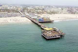
Aerial view of Santa Monica Pier, Santa Monica. Highsmith, Carol M
Pasadena
There are several sites in Pasadena that are listed in the National Register of Historic Places: Foothill Boulevard Milestone, Howard Motor Company Building, Colorado Street Bridge, Bekins Storage Co. and the Rialto Theatre (which is in South Pasadena on an older alignment of Route 66); there are several US 66 alignments from Pasadena into Los Angeles: the original 1926 one that ended in downtown Los Angeles, later 1930-40s variants through Northeast Los Angeles, and the late 1940s ⁄ 50s road which we describe below:
Route 66 into Los Angeles
See all the Route 66 alignments in L.A.
In downtown Pasadena turn left onto Arroyo Parkway southwards which becomes CA 110 and in South Pasadena turns west as Arroyo Seco Parkway (which is a Historical Place). It passes on the north side of Montecito Heights, and right in front of the Dodger Stadium and take Exit onto US 101 N, (right - 311 miles), this is the Hollywood Freeway.
At Exit 7, leave US 101 towards Santa Monica Blvd. (315 miles) and take a left along Santa Monica Blvd. (CA 2) Here you will meet the 1930s and 40s alignment again.
Hollywood
The Boulevard takes you through the heart of Hollywood and West Hollywood famous for its Sunset Strip, and then it takes a southwesterly direction through Beverly Hills and passes under I-405 (325 mi.).
Santa Monica
Terminus
Original US 66 ended in downtown Los Angeles (1926) it was later moved to the Pacific Coast Highway (then US 101 Alternate) which is current SR 1, in Santa Monica, California.
It heads towards the sea, through Santa Monica. Where it used to end, on Lincoln and Olympic Blvd. in the 30's and 40's.
But don't turn left on Lincoln Blvd. Keep straight ahead to its western terminus, on Ocean Avenue, 0.3 miles north of the Santa Monica Pier. End of Route 66. (333 miles).
There is plaque at Ocean Ave. and Santa Monica Blvd. that dedicates US 66 as the Will Rogers Highway.
Accommodation Search box:

Some sponsored content:
>> Book your Hotel in Rolla

Credits
Banner image: Hackberry General Store, Hackberry, Arizona by Perla Eichenblat.